BALANCE. Kick-off Meeting, Copenhagen, Denmark. 31st of August - 1st of September 2005
|
|
|
- Donna Roberts
- 5 years ago
- Views:
Transcription
1 BALANCE Baltic Sea Management - Nature Conservation and Sustainable Development of the Ecosystem through Spatial Planning Kick-off Meeting, Copenhagen, Denmark 31st of August - 1st of September 2005 Johnny Reker The Danish Forest and Nature Agency (Balance@sns.dk)
 Concepts Data & metadatabase Baltic")
2 INTRODUCTION Bubbling reef in the northern part of Kattegat. Photo: Dan Kaasby Setting the scene The BSR INTERREG IIIB programme The BALANCE aim Project structure (WP1-5) Concepts Data & metadatabase Baltic marine landscapes Holistic habitat mapping MPA analysis & blue corridors Baltic Sea zone planning

3 SETTING THE SCENE BSR INTERREG IIIB region. The BALANCE project area includes The Baltic Sea, Kattegat & Skagerrak Conditions has been met 19 partners + 7 consultants 10 countries incl. Norway & U.S.A but excl. Russia Budget Є4,3 mio. + Є0,4 mio. in non-eligible funding Runs 2½ year from 1/ Covers the entire Baltic Sea Largest project funded by the BSR INTERREG IIIB Programme
4 BSR INTERREG IIIB Measure 2.3 Enhancing good management of cultural and natural heritage, valuable landscapes and natural resources Objectives: Using and strengthening the main assets of natural and cultural heritage in the interest of the entire Baltic Sea Region. Protecting and develop a continuum of natural landscapes as important elements in a BSR ecological network and green corridors. Promoting an efficient use and wise management of the BSR natural resources without endangering a necessary transformation of the economy of respective areas, strengthening sustainable forestry and energy production.
5 BSR INTERREG IIIB Measure 2.3 Expected impacts of the measure: Developing spatial planning as a forceful tool for sustainable use of limited resources Identifying green corridors and valuable natural areas for inclusion in the NATURA 2000 network Fostering an increased public awareness of limited resources Integrated strategies for and sustainable management of valuable cultural landscapes and rural development
6 Aim: BALANCE AIM Development of an informed management template for the Baltic Sea focused on marine spatial planning and cross-sectoral & transnational co-operation. Actions: 1 Identify & collation of available BS marine data (physical, biological, socio-economic), meta-database 2 Development of BS marine landscape & habitat maps 3 Assessment of the Baltic MPA network & development of the blue corridors concept 4 Stakeholder communication strategy & dissemination of results 5 Development of Baltic marine zoning plans in 2 pilot areas
7 PROJECT STRUCTURE W P 1 D a t a m a n a g e m e n t W P 2 H a b i t a t s W P 3 N A T U R A M W P 4 a n a g e m e n t t e m p l a t e W P 5 D is s e m in a t io n D a ta c o l l a ti o n M a r i n e l a n d s c a p e s " B l u e c o r r i d o r s " B S s p a ti a l p l a n n i n g D r a f t z o n in g p la n s b a s e d o n h a b it a t m a p s B A L A N C E w e b s i te M e t a - d a ta b a s e H a b i ta t m a p s E c o l o g i c a l c o h e r e n t N A T U R A n e tw o r k M a n a g e m e n t e f f i c i e n c y s c i e n ti f i c p a p e r s N e w s p a p e r s e t c. P r o to c o l s & s ta n d a r d s P r e d i c ti v e m o d e l s S ta k e h o l d e r i n v o l v e m e n t F i e l d te s ts & P i l o t a r e a s

 Stakeholder / socio-economic data: Fisheries, shipping, cultural heritage, leisure")
8 DATA Sea floor and trawl lines, Fiskeriverket Data collation & metadatabase Metadata: Who, where, why, when, how - survey, how - mapping Scientific data: Physical (bathymetry, geology etc.) Biological (infauna, fish etc.) Added value (sensitivity etc.) Stakeholder / socio-economic data: Fisheries, shipping, cultural heritage, leisure activities etc.
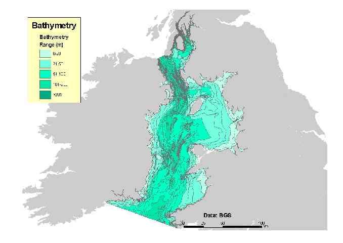
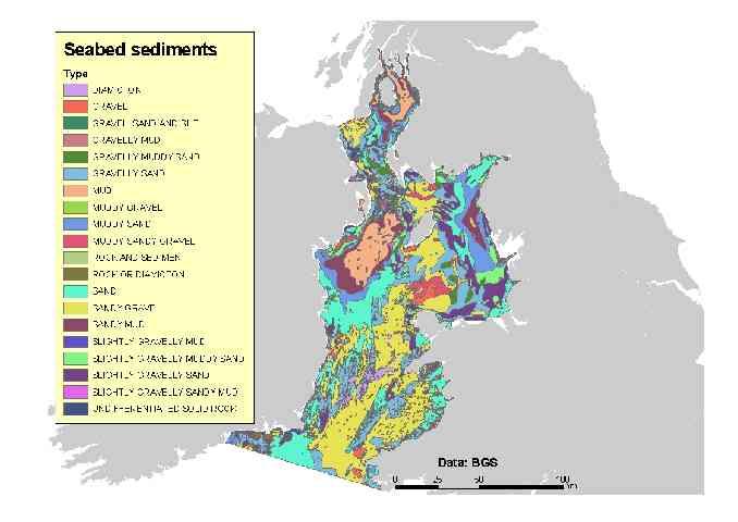
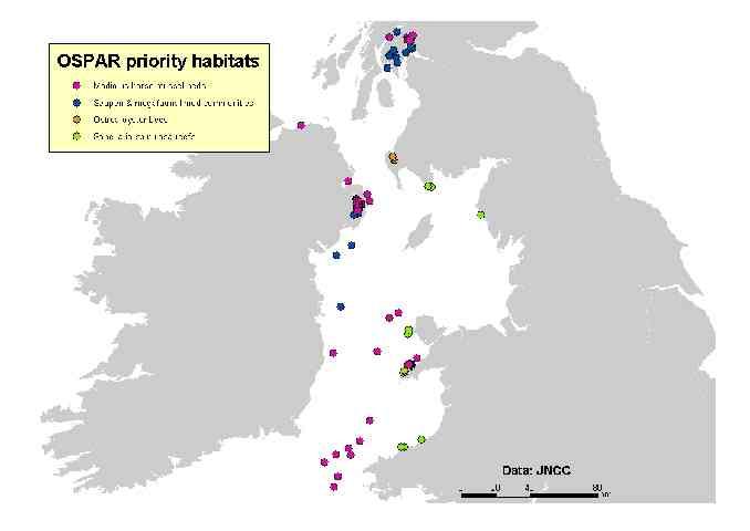
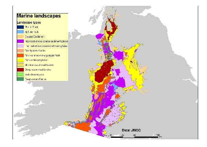
9 UK MARINE LANDSCAPES

10 BALTIC MARINE LANDSCAPES? Soft sediments and MPA s in Danish waters. Source: GEUS & SNS
 The")
")
")

 Gulf")
11 PILOT AREAS 1) The Northern Kattegat 3) Åbo- Åland -Stockholm 2) The Bornholm Deep & Pomeranian Bay 4) Gulf of Riga & Lithuanian Coast


12 MARINE HABITATS Benthic habitats Essential fish habitats Pelagic habitats
, The Royal Danish")


13 DATA SETS IN PILOT AREA 1 Multibeam coverage (red), The Royal Danish Administration of Navigation & Hydrography Multibeam on the Swedish west coast & trawl effort. Fiskeriverket Stations with data on infauna on sand and soft sediment, NERI.
14 MPA ANALYSIS Broad scale assessment: 1) Continuum of marine landscapes (representativity) 2) Coherence between marine landscapes Detailed assessment: Soft sediments and MPA s in Danish waters. Source: GEUS & SNS 1) Continuum of habitats 2) Coherence between habitats
 Fish migration from spawning areas to feeding grounds (Cod, Pike etc.")

15 BLUE CORRIDORS Infauna larval dispersal by dominating currents to vulnerable areas (distance, time of spawning etc.) Fish migration from spawning areas to feeding grounds (Cod, Pike etc.) Fucus serratus spore dispersal need hard bottom stepping stones Crab migration increased by vegetative corridors e.g. Zostera marina beds Needed for an ecological coherent Natura 2000 & MPA network
16 PLANING THE BALTIC SEA Broad-area integrated management based on zoning of a large area is more effective than management of small isolated areas, because: Ecologically - it recognises temporal/spatial scales at which the ecosystem operates. Practically - it is easier to manage, it buffer and dilutes impacts of activities in adjacent areas to e.g. MPAs. Socially - help to resolve and separating conflicting uses thus ensuring all reasonable uses can occur with minimum conflict. Economically - integration within a larger area will have lower costs per spatial area than a series of small separate MPAs. Modified from Day et al. 2003
17 Natural Heritage & Living Resource Identification through habitat mapping Intertidal mudflat Coastal Lagoon Reef Sandbank Zostera beds & fish spawning area Off shore reef Cod Habitat Off shore sandbank Soft sediment Seabird & Seal colonies Reef
18 Activity Identification & Monitoring Port Saltmarsh & Mudflat (SPA, Ramsar, etc.) Marina & Fishing Harbour Amenity Beaches & Bathing Waters Jetski & Windsurfing Possible Wind farm Shipping Route Offshore fisheries Sailing Sand and Gravel Extraction Seabird colony (SPA) Special Area of Conservation (SAC) Modified from R. Hill, MSUO
19 Potential stakeholder conflicts? Grounding & Collision Amenity Loss Stakeholder Conflict Collision Economic Loss Habitat Damage Wildlife Disturbance Sustainable development? Grounding Modified from R. Hill, MSUO

20 Zone planning based on natural heritage, living resources and stakeholder interests Spatial & temporal plannin Relocation Rerouting Integrated informed management Off shore sandbank Combined NATURA 2000 & fisheries management? Biodiversity Hotspot
21 BALTIC ZONE PLANING Data review, collation and access (WP1). Classification & habitat mapping (WP2). Review of existing MPAs (WP3). Identification of potential new networks that achive the ecological and socio-economic objective of sustainable development (WP3). Selection of an optimal network that maximise beneficial and minimise detrimental impacts considering social, economic & management implications (WP3&4). Draft zoning plan - prepare, and release for public comments, a draft inshore and off shore zoning plan (WP3&4). Final zoning implemented (life after BALANCE). Modified from Day et al. 2003

22 THANK YOU FOR YOUR ATTENTION! For futher information