DUBUQUE COUNTY SMART PLAN Watershed Management
|
|
|
- Tyler Warren
- 5 years ago
- Views:
Transcription

1 Introduction Dubuque County Watersheds are in a state of constant change. Land use changes, Agricultural farming practices, and urban development has produced habitat alteration and a drastic increase in the rate and volume of stormwater inputs. Understanding the importance of land use planning, the impacts of infiltration based practices, and developing site specific boundaries of non-point source pollution within a watershed will lead to improvements in our local watersheds. One of the goals of this plan is to work towards repairing the damage done to in-stream habitat and reduce the rate and volume of stormwater flow using infiltration based practices. Understanding Stormwater The Hydrologic Cycle The hydrologic cycle, illustrated in Figure 3-1, is the movement of water from the atmosphere to the earth s surface. Water moves through one or more components of the cycle including evaporation, transpiration, runoff, precipitation, infiltration, percolation and its eventual return to the atmosphere. In an undeveloped area, with natural ground cover such as forest or meadow, a significant portion of precipitation infiltrates into the soil. This water is filtered and cooled as it travels underground. Some infiltrated water is subsequently discharged into rivers and streams as baseflow. Baseflow provides a steady contribution of high quality water to lakes, streams and rivers. Other infiltrated water descends deeper underground to the water table and recharges aquifers. Groundwater recharge replenishes the supply of underground water that can be extracted for domestic use and irrigation. Another portion of precipitation is returned to the atmosphere through a combination of evaporation and plant transpiration called evapotranspiration. Where there is natural ground cover, all of these processes together serve to minimize the percentage of precipitation that becomes runoff, the water that flows over that land surface into streams and other surface water bodies. Figure 3-1: The Hydrologic Cycle Adapted from: The Physical Environment: An Introduction to Physical Geography Urbanization dramatically affects the hydrologic cycle by altering the relative percentage of precipitation that contributes to groundwater, evapotranspiration, and runoff relative to the natural 1
2 ground cover. Specifically, urbanization increases runoff by decreasing the amount of water that infiltrates into the ground and is taken up and transpired by plants. This is because water cannot infiltrate into, and plants cannot grow on, impervious surfaces such as pavement and rooftops. Figure 3-2 illustrates how watershed imperviousness affects the magnitude of each of the hydrologic cycle components. Increased stormwater runoff not only decreases baseflow and groundwater recharge, but also increases the amount of water that runs off the surface, picking up and carrying pollutants to lakes, streams, rivers and wetlands. The increased surface runoff increases flooding frequency and severity while the increased input of pollutants degrades water quality and aquatic habitat. Figure 3-2: Impact of Impervious Area on the Hydrologic Cycle Fluxes Adapted from: Prince Georges County Department of Environmental Resources Programs and Planning Division, Low-impact Development Design Strategies: An Integrated Design Approach. Department of Environmental Resources, Prince Georges County, Maryland. Establishing countywide standards for the quantity and quality of water that runs off land under construction in urban and rural areas, including farms will play a crucial role in protecting our watersheds in Dubuque County. Providing flexibility in meeting those standards, and recognizing the unique characteristics of each project site, will be equal as important. 2
3 Construction site erosion and uncontrolled stormwater runoff from land disturbing and land development activities have significant adverse effects upon regional water resources including the health, safety, property and general welfare of the community, diminishing the public enjoyment and use of natural resources. Effective erosion control, sediment and stormwater management depends on proper planning, design, timely installation and continued maintenance of erosion control and stormwater management practices. Specifically, soil erosion and stormwater runoff can: Carry sediment, nutrients, pathogens, organic matter, heavy metals, toxins and other pollutants to regional lakes, streams and wetlands; Diminish the capacity of water resources to support recreational and water supply uses and a natural diversity of plant and animal life; Clog existing storm drainage systems, increasing maintenance problems and costs; Cause bank and channel erosion; Increase downstream flooding; Reduce groundwater recharge, which may diminish stream base flows and lower water levels in regional lakes, ponds and wetlands; Contaminate drinking water supplies; Increase risk of property damage and personal injury, and; Cause damage to agricultural fields and crops Good stormwater management does not begin with site disturbance and construction. Decisions about lot layout, building density, location of public rights-of-way, protection of sensitive areas, and preservation of open space all have an impact on the quality and quantity of stormwater runoff. When using site-planning techniques to control stormwater, designers should keep local zoning, land division and building codes in mind. Many communities have adopted site design or land division criteria to serve a variety of land use goals that may or may not directly relate to stormwater runoff. Examples include: Preserving neighborhood or rural character Protecting specific natural or scenic resources Promoting smooth traffic flow Allowing for future land division Ensuring adequate pedestrian, bicycle or emergency vehicle access Usually, such goals complement or reinforce good design for stormwater control. However, in some cases, such as choosing between grid-pattern or cul-de-sac street layouts, the designer may need to strike a balance between competing land use goals. For example, in a community seeking to promote traditional neighborhood design, engineered stormwater basins may be preferable to a curvilinear street layout. Many techniques can be employed during the site planning and design stage of development to reduce the volume of runoff, thus reducing the need for structural practices to store and treat stormwater. Design and location of stable outlets for site runoff is also important to consider at this time, to avoid causing problems for downstream neighbors. Consider implementing the following techniques (which 3
4 are listed in order of priority) and manage runoff as close to the source as possible to minimize the volume of stormwater runoff. A. Identify and Avoid Sensitive Areas Local variations in topography, soil types, vegetation and hydrology can have a significant influence on the nature and amount of stormwater runoff. The first step in site planning for stormwater management should be identification and mapping of areas that: Contain features that could be adversely impacted by stormwater runoff (such as wetlands, floodplains, lakes, streams, and shallow fractured bedrock); In their natural state, contribute to infiltration, soil and water retention, groundwater recharge or temperature control (such as highly pervious soils, native grasslands, woodlands or hydric soils); Provide natural drainage ways for surface water runoff (such as intermittent or perennial streams, natural or artificial drainage ways); or Could be a source of sedimentation, channelized flow or erosion if disturbed (such as steep slopes or easily eroded soils). Contain cultural resources, which are protected by federal law. Cultural resources can be found at: Development should be designed and construction operations planned to avoid disturbing these areas wherever possible. Federal, state or local regulations protect some natural features, such as wetlands or navigable waterways. Changes in volume and direction of stormwater flow resulting from development or other stormwater practices should be carefully designed and controlled to avoid secondary impacts to natural areas. For example, increased runoff volume can erode streambeds and banks or damage natural wetlands without careful consideration early in the planning process. Working around sensitive areas should be incorporated as part of the preliminary design, which not only avoids these areas but also highlights them as natural amenities that add value to the development. These sensitive areas complement the functions and values provided by the countywide network of open space corridors. B. Minimize Impervious Surfaces Impervious surfaces are the primary source of runoff in both small and large storm events. Hence, the single most effective means of reducing runoff volume is by minimizing the site s impervious surface area. 1. Preserve and Reproduce Pre-Development Hydrologic Conditions Utilize natural drainage flow paths. Dubuque County strongly recommends the use of grass waterways, vegetated drainage channels and/or water quality swales along street right-ofways or back lots to channel runoff without abrupt changes in the direction of flow. Restore soil permeability. Use practices such as deep tilling, chisel plowing and incorporating organic matter into the upper soil layer to restore soil infiltration capacity on heavily disturbed sites. When soil is compacted, its capacity to infiltrate water is greatly diminished. On heavily disturbed sites where practices are used to restore soil permeability, the county may waive the requirement to lower the soil permeability class rating in hydrologic calculations (see 3.2.B, Chapter 3, below). 4
5 Minimize directly connected impervious area. Any impervious surface that drains into a catch basin, area drain, or other conveyance structure is a directly connected impervious area (DCIA). Impervious surfaces also increase the runoff rate (reducing the runoff time of concentration) and runoff volume, which may cause higher peak flows downstream, and increase flood and erosion potential. To minimize directly connected impervious areas, downspouts and driveways should be directed to pervious areas, where feasible. This promotes infiltration and reduces the velocity of runoff water. Other strategies for minimizing connected impervious area include directing sheet flow through vegetated areas and locating impervious areas so they drain to vegetated buffers or other pervious areas. Use bioretention and other practices to increase infiltration. Bioretention basins are engineered practices that use natural processes, including microbial soil processes, infiltration, and evapotranspiration to improve stormwater quality. Rain gardens, often very attractive, are one type of practice commonly designed for residential lots to soak up rainwater from roofs, driveways, and lawns. Include green infrastructures. Developed areas may provide self-treatment of runoff via the use of green infrastructures if properly designed and drained. Green infrastructures may consist of conserved natural spaces, large landscaped areas (including parks and lawns), grass/vegetated swales, and turf block paving areas. The infiltration and bio-treatment inherent to such areas may provide the treatment control necessary. These areas therefore act as their own BMP, and no additional BMPs to treat runoff should be required. 2. Site and Lot Vegetation Predevelopment vegetation. Maintain as much predevelopment vegetation as possible. Vegetation prevents erosion and absorbs water and, therefore, reduces runoff volume. Swales. Use shallow grassed roadside swales, boulevards and sunken parking lot islands with check dams instead of curb and gutter storm drain systems to handle runoff, wherever possible. Natural buffers and drainage ways. Maintain natural buffers between development sites and water bodies. Buffers slow runoff, remove sediment and enhance infiltration. Natural depressions and channels should be maintained to slow, store, and infiltrate water. 3. Streets and Roads Road length. Minimize subdivision roadway length by using a roadway layout with the least pavement length suitable for the site s topography and other planning goals. Road width. Work within local zoning requirements and planned unit development provisions to minimize road width by narrowing road sections and/or reducing on-street parking. On-street parking may be restricted to one side of the street or eliminated altogether. Pavement and right of-way width must still meet minimum standards described in local land division and zoning ordinances, and should allow for safe vehicular travel and emergency vehicle access. Design road patterns to match landforms. In rolling terrain, for example, local streets should branch from collector streets and end in short loops or cul-de-sacs, where consistent with other local ordinances and land use goals. Some local ordinances and plans seek to create traditional grid patterns or limit the use of cul-de-sacs to address traffic, neighborhood character or other design objectives. 5
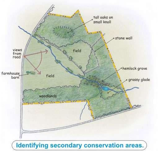
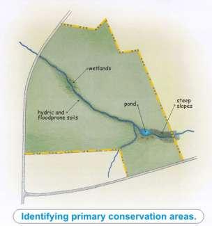
6 4. Lot Layout Rooftops. Reduce the impervious rooftop area by minimizing the building footprint of houses or utilizing green roof technology. Use vertical space rather than horizontal house layouts. Sod or vegetative green roofs rather than conventional roofing materials. Driveways. Where permitted under local driveway, zoning or land division ordinances, reduce impervious driveway area by using shared driveways, limiting driveway width, using pervious pavement, and using reduced building setbacks. Parking lots. For commercial sites, reduce overall impervious area by providing compact car spaces, eliminating excessive or unnecessary spaces, utilizing shared parking, minimizing stall dimensions, incorporating efficient parking lands, and using pervious materials in spillover parking areas. C. Low-Impact Development (LID) and Conservation Subdivision Design Many of the practices and techniques discussed above are commonly referred to as low-impact design or conservation subdivision design. Both low impact designs and conservation subdivisions have common goals; however, they have different strategies in obtaining that goal. Low Impact Development is a site design strategy with a goal of maintaining predevelopment hydrologic conditions by managing runoff at the source using uniformly distributed stormwater management facilities. Instead of conveying and treating stormwater in large facilities located at the bottom of drainage areas, LID addresses stormwater through small, cost-effective landscape features located at the lot level. The low-impact analysis and design approach focuses on the following hydrologic analysis and design components: i. Runoff curve number (RCN): Minimizing change in post-development hydrology by reducing impervious areas and preserving more trees and meadows to reduce the storage requirements to maintain the pre-development runoff volume. ii. Time of concentration (Tc): Maintaining the pre-development Tc in order to minimize the increase of the peak runoff rate after development by lengthening flow paths and reducing the length of the runoff conveyance systems. iii. Infiltration: Manage water quality volume through infiltration. iv. Retention: Providing permanent pool storage for volume and peak control, as well as water quality control, to maintain the same storage volume as the pre-development condition. v. Detention: Providing additional storage above permanent pool levels, if required, to maintain the same peak runoff rate and/or prevent flooding for storm recurrence intervals 5-10 years. Conservation subdivision designs are characterized by common open space and clustered compact lots. The purpose of a conservation subdivision is to protect sensitive and valuable open space, habitat and other environmental resources while allowing for the maximum number of residences under current community zoning and subdivision regulations. Figure 1-1 and 1-2 compares a conventional subdivision layout with a subdivision incorporating conservation design practices. 6

7 Figure 1-1: Conservation Design Subdivision Layout 7


8 Source: Figure 1-2: Comparing Conventional and Conservation Subdivisions. Source: Ordinance for a Conservation Subdivision, UWEX, Brian Ohm. During plan review, LID and conservation subdivision design and other practices may need to be evaluated to ensure that the land division meets or exceeds subdivision ordinance requirements or planned-unit development (PUD) approval procedures. 8
9 Cost Considerations Incorporating LID. Often times, critics of conservation design and LID practices raise concern over the high costs of incorporating LID into subdivisions. What may seem like a simple question, can often be very difficult to analyze and has several dimensions, making it more of a complex topic. It is important to analyze the word costs by several dimensions: planning, design, capital costs, short-term vs. long-term maintenance, land values, transportation surfaces, and environmental impacts. Table 1-3 (below) is offered to help planners, engineers, regulators, and developers compare the costs and benefits of LID with a more conventional land development approach. Qualitative Cost Comparison How LID Practices Compare with Conventional Practices LID Practice Design Construction Long-Term Increased Land Decreased Costs Costs Maintenance Values Environmental Costs Better Site Design Better Local Roads Bioretention/Rain Gardens Infiltration/Permeable Pavements (1) (1) Stormwater Planters Vegetated Swales Vegetated Buffers Cisterns/Rain Barrels (1) Green Roofs (1) Key : Impact - LID practice compares favorably with conventional approach (e.g., costs less) - LID practice compares unfavorably with conventional approach (e.g., costs more) - Too close to determine, site conditions or other factors may affect cost (1) - Costs may be too close to call, or even favorable when all costs such as heating, cooling, roof replacement, irrigation, or additional downstream detention are considered. Source: Massachusetts State, Smart Growth/Smart Energy Toolkit 9
10 D. Watershed-Wide Planning for Stormwater Management The Dubuque County Manual, while focusing on plans and practices to meet the erosion control and stormwater needs of particular sites, encourages watershed-wide planning. Ideally, stormwater management should be conducted as part of a watershed plan. In watershed-wide planning, communities can work together across municipal boundaries to identify potential locations for regional stormwater treatment facilities, and coordinate on-site basins and outlets to reduce the effect of combined peak discharges after storm events. They can also collectively identify areas where stormwater treatment facilities should not be located, e.g. in hydric or alluvial soils, and target areas where they are preferred, e.g. deep sandy soil. Such a collaborative approach may result in significant cost savings from economies of scale and shared responsibility. E. Regional Stormwater Management Using individual, onsite structural stormwater management facilities for each development is the typical approach for downstream flood control. The developer finances the design and construction of these management facilities, and is initially responsible for all operation and maintenance. A potential alternative approach is for a community to install strategically-located regional stormwater management facilities in a sub-watershed rather than require onsite management facilities. Regional stormwater management facilities are designed to manage stormwater runoff from multiple projects and/or properties through a local jurisdiction-sponsored program, where the individual properties may assist in the financing of the facility, and the requirement for onsite management facilities is either eliminated or reduced. Table 1-3 lists some advantages and disadvantages of regional facilities as compared to individual on-site facilities. Table 1-3: Advantages and Disadvantages of Regional Stormwater Management Facilities Advantages Reduced construction costs Reduced operation and maintenance costs Ability to serve as a recreational and aesthetic amenity for a community Ability to maximize the intent of the proposed project. (The area set aside for stormwater management facilities is minimized) Higher assurance of maintenance Mitigates existing developments with insufficient stormwater management facilities while also providing for future development Disadvantages Determining an effective location can be difficult Initial capital costs can be high Substantial planning, financing and permitting are required. The local government may need to establish a stormwater utility or alternative program to fund and implement stormwater control. If a community decides to implement a regional stormwater control, it must ensure that the conveyances between the individual upstream developments and the regional facility can handle the 10
11 design peak flows and volumes without causing adverse impact or property damage. Full build-out conditions in the regional facility drainage area should be used in the analysis. In addition, unless the system consists of completely man-made conveyances (i.e. storm drains, pipes, concrete channels, etc.); onsite structural management facilities for water quality and downstream channel protection will be required for all developments within the facility s drainage area. Federal water quality provisions do not allow the degradation of water bodies from untreated stormwater discharges, and it is U.S. EPA policy to not allow regional stormwater management facilities that would degrade stream quality between the upstream development and the regional facility. Without onsite water quality and channel protection, regional management facilities do not protect smaller streams upstream from the facility from degradation and stream bank erosion. Upstream inundation from a regional facility impoundment can eliminate floodplains, wetlands, and other habitat. Further, without adequate channel protection, aquatic habitats and water quality in the channel network upstream of a regional facility may be degraded by stream bank erosion if they are not protected from bank-full flows and high velocities. Based on these concerns, both the EPA and the U.S. Army Corps of Engineers have expressed opposition to in-stream regional stormwater control facilities. In-stream facilities should be avoided if possible, and will likely be permitted on a case-by-case basis only. F. Dubuque County Erosion Control and Stormwater Ordinance In March of 2010, the Dubuque County Board of Supervisors passed a County wide Erosion Control and Stormwater Management Ordinance. In addition to the Ordinance, Dubuque County worked with a local engineering firm to complete a Stormwater Management Manual. This manual can be found online at or by visiting the Dubuque County engineering or zoning office. The manual does an excellent of detailing applicability, performance standards, and management practices that can be used in both pre-construction and postconstruction practices. 11