WATER POWER ACT & ENVIRONMENT ACT LICENCES 2013 ANNUAL WATER LEVELS REPORT FOR WUSKWATIM GENERATING STATION
|
|
|
- Willa Tate
- 5 years ago
- Views:
Transcription
1 Hydraulic Operations Department, Manitoba Hydro On behalf of: Wuskwatim Power Limited Partnership WATER POWER ACT & ENVIRONMENT ACT LICENCES 2013 ANNUAL WATER LEVELS REPORT FOR WUSKWATIM GENERATING STATION Originally Signed by M.J. Duenas Originally Signed by M.J. Duenas PREPARED BY: L 12.0 REVIEWED BY: Originally Signed by B.W. Giesbrecht IMPORTANT THIS MATERIAL IS THE EXCLUSIVE PROPERTY OF MANITOBA HYDRO AND ALL RIGHTS ARE RESERVED ANY RELEASE, REPRODUCTION OR OTHER USE THEREOF WITHOUT THE EXPRESS WRITTEN CONSENT OF MANITOBA HYDRO, IS STRICTLY PROHIBITED APPROVED BY: DATE: REPORT NO GIESBRECHT Originally Signed by W.V. Penner W.V. PENNE PS&O DISTRIBUTION. R MATTHEWS (MANITOBA CONSERVATION & WATER STEWARDSHIP) B. WEBB (MANITOBA CONSERVATION & WATER STEWARDSHIP) J.A. KREML (GENERATION NORTH) E.A. NEVILLE (ABORIGINAL RELATIONS) RECORDS MANAGEMENT CORPORATE LIBRARY
2
3 Wuskwatim Generating Station Water Power Act & Environment Act Licences Annual Report EXECUTIVE SUMMARY During the 2013 reporting period from January 1 to December 31, Wuskwatim Generating Station (GS) licence constraints were met 99.93% of the time. Manitoba Hydro operates the Wuskwatim GS on behalf of Wuskwatim Power Limited Partnership in accordance with the Water Power Act and Environment Act licences issued by the Province of Manitoba. These licences constrain the water level on Wuskwatim Lake, and the rate of change in water level on Birch Tree Lake. Environment Act Licence No for Wuskwatim GS requires an annual water level report for each calendar year. This report addresses all water level constraints imposed by both the Water Power Act and Environment Act licences. The report contains information on data collection, validation, and reporting, as well as a summary of licence compliance violations during the year. Manitoba Hydro obtained all necessary water level data from the hydrometric databases to prepare this report. Data were processed to analyze water conditions at licence specific locations during the 2013 reporting period. Licence limit violations were identified by evaluating water levels against licence limits. The monthly reports recorded six licence limit violations during 2013 using raw gauge data. However, using final data reveals that only five of these events are confirmed. The sixth event was the result of incorrect gauge data. Two events exceeded the maximum mean daily water level on Wuskwatim Lake and three events exceeded the maximum mean daily water level variation on Birch Tree Lake. The reasons for the occurrence of these events were explained in Section 5.3 and in Appendix I. In summary, water levels deviated outside the licence limits 0.07% of the time as follows. Date Location Constraint Variable April 3, 2013 Wuskwatim Lake Max Elevation Mean Daily Water Level September 16-18, 2013 Wuskwatim Lake Max Elevation Mean Daily Water Level February 7, 2013 Birch Tree Lake Water Level Variation July 4, 2013 Birch Tree Lake Water Level Variation October 13, 2013 Birch Tree Lake Water Level Variation Mean Daily Water Level Mean Daily Water Level Mean Daily Water Level Hydraulic Operations Department i Report No. PS&O 14/03 Power Sales & Operations Division May 27, 2014
4
5 Wuskwatim Generating Station Water Power Act & Environment Act Licences Annual Report TABLE OF CONTENTS 1.0 INTRODUCTION Background Objective Outline WUSKWATIM GENERATING STATION Project Location Project Description DATA COLLECTION Water Level Gauges Data Transmission and Storage WATER POWER ACT & ENVIRONMENT ACT DATA REPORTING Monitoring & Reporting Process Data Sources Compliance Compliance Reporting SUMMARY OF FINDINGS Data Analysis Licence Violations Licence Violations Explanation MAJOR SYSTEM UPGRADES/CHANGES CONCLUSIONS & CLOSURE APPENDICES APPENDIX I Correspondence with Manitoba Conservation and Water Stewardship regarding licence limit violations and incident compliance report. APPENDIX II Wuskwatim Generating Station Licence Implementation Guide for Water Levels, Prepared for Manitoba Water Stewardship by Hydraulic Operations Department, On behalf of Wuskwatim Power Limited Partnership, July 2007, Report No. PS&O 07/03. Hydraulic Operations Department ii Report No. PS&O 14/03 Power Sales & Operations Division May 27, 2014
6
7 1.0 INTRODUCTION 1.1 Background Wuskwatim Power Limited Partnership (WPLP) is a legal entity involving Nisichawayasihk Cree Nation (NCN) and Manitoba Hydro, which developed and now owns the Wuskwatim Generating Station (GS). Manitoba Hydro operates the station as part of the Manitoba power grid on behalf of WPLP. WPLP received licences under the Water Power Act and the Environment Act for the development of the Wuskwatim GS. The Interim Water Power Act licence stipulates a maximum and minimum allowable water level on Wuskwatim Lake. The Environment Act Licence No stipulates a maximum and minimum water level on Wuskwatim Lake, a maximum daily change in water level on Birch Tree Lake, as well as monthly and annual reporting requirements. This report fulfills the annual reporting requirement of Environment Act Licence No Manitoba Hydro, in collaboration with Manitoba Conservation and Water Stewardship, prepared the Wuskwatim GS Licence Implementation Guide for Water Levels to establish and document the water regime terms specified by the Wuskwatim licences. The Licence Implementation Guide forms the basis for content of this report, is included as Appendix II, and provides the following details: o calculation methodology to be used for determining critical levels, o protocol for reporting to meet licence requirements, and o manner in which compliance will be defined and assessed. 1.2 Objective The objective of this report is to report on Wuskwatim GS licence compliance by summarizing the Water Power Act and Environment Act licence requirements and providing the relevant water level data for the 2013 reporting period. In the case of any licence violation, this report provides the reason for the violation, actions taken to prevent such an event from occurring in the future, and proof of regulator notification. 1.3 Outline Section 1.0 contains the introduction to the report, including background information on licence and reporting requirements, objective and outline of the report. Following the introduction is section 2.0, which provides the Wuskwatim GS project location and description. Section 3.0 summarizes the water level data collection process including data transfer, storage and validation. Section 4.0 includes information about data sources, definition of compliance, and compliance reporting. Section 5.0 describes the data analysis used to prepare this report, includes a summary table of deviations from licence constraints during the 2013 calendar year, and provides reasons for any licence deviations. Section 6.0 summarizes major system upgrades Hydraulic Operations Department 1 Report No. PS&O 14/03 Power Sales & Operations Division May 27, 2014
8 or changes during the 2013 calendar year, and finally Section 7.0 provides conclusions and closure to the report. Appendix I provides copies of relevant correspondence with Manitoba Conservation and Water Stewardship related to licence violations and the compliance report issued during the 2013 reporting period. Appendix II contains a copy of the Licence Implementation Guide, which contains all required background information related to the definitions of compliance and compliance reporting. The enclosed CD contains final water level data for Wuskwatim Lake and Birch Tree Lake used in the preparation of this report. Hydraulic Operations Department 2 Report No. PS&O 14/03 Power Sales & Operations Division May 27, 2014
9 2.0 WUSKWATIM GENERATING STATION 2.1 Project Location The Wuskwatim Generating Station is located on the Burntwood River, in the Nelson House Resource Management Area, approximately 56 km southwest of Thompson, 35 km southeast of Nelson House, or approximately 830 km north by road from Winnipeg. The geographical location of the station is shown in Figure 1. A photograph of the station is shown in Figure 2. A general arrangement of the site is shown in Figure Project Description The Wuskwatim Generating Station consists of a 3-unit powerhouse with a nameplate capacity of 209 MW, gravity dams and embankment structures, and a 3- bay spillway with heated gates. Tables 1 and 2 summarize the operating parameters and construction specifications of the Wuskwatim Generating Station. Table 1: Construction Specifications and Operating Parameters of the Wuskwatim Generating Station Construction Period 2006 to 2012 Licensed Capacity 210 MW 2013 Generation 1,488 million kw-h Waterfall Drop (head) 21.4 m Maximum Licence Forebay Elevation m Minimum Licence Forebay Elevation m Table 2: Principal Structures for the Wuskwatim Generating Station Number of Units 3 Length 75 m Powerhouse Discharge Capacity (at full gate) 1,100 m 3 /s Power Production MW/unit TOTAL = 209 MW Number of Bays 3 Spillway Total Length 43.0 m Discharge Capacity (Wuskwatim m) 2,310 m 3 /s Dams Material Impervious fill and granular fill Crest Elevation m The reservoir at Wuskwatim Generating Station has a total area of km 2 and a fetch length of approximately 1.88 km. There is a 0.1 m drop between the reservoir level on Wuskwatim Lake and the forebay level of the station. The reservoir normal Hydraulic Operations Department 3 Report No. PS&O 14/03 Power Sales & Operations Division May 27, 2014
10 maximum water level is m while the forebay normal maximum water level is m. The incremental flooded area due to the project is 0.37 sq. km allowing the majority of the reservoir and forebay to be contained by natural river banks and minimizing the need for dykes. As the only generating station on the Burntwood River, Wuskwatim s inflow is largely dependent on the Churchill River Diversion, as controlled by the Notigi Control Structure. The generating station operates in a daily cycling mode within the allowed 0.25 m water level range on Wuskwatim Lake. The operators and maintenance personnel of the Wuskwatim Generating Station are located on site. Support and technical services are also located in the nearby city of Thompson. Hydraulic Operations Department 4 Report No. PS&O 14/03 Power Sales & Operations Division May 27, 2014
11 3.0 DATA COLLECTION 3.1 Water Level Gauges Hydraulic Operations staff compiled data from five remote water level gauges located on Wuskwatim Lake, and four remote water level gauges located on Birch Tree Lake to evaluate licence compliance for the 2013 reporting period. The locations of the water level gauges as well as the gauge description sheets are contained in the Licence Implementation Guide appendices. Manitoba Hydro uses the recorded water level data to measure compliance with the licence conditions as they apply to hourly and mean daily water levels (with wind and wave effects eliminated) on Wuskwatim Lake, and daily average water level changes on Birch Tree Lake. 3.2 Data Transmission and Storage Manitoba Hydro remote gauges on Wuskwatim and Birch Tree Lakes, use pressure transducers and data loggers to send water level data to satellites operated by the National Oceanic and Atmospheric Administration (NOAA). NOAA sends the signal to DOMSAT, a domestic communications satellite operated by NOAA. Manitoba Hydro servers retrieve the data from DOMSAT using a data collection system (DCS) Toolkit. The DCS Toolkit is auto-collection software that sends the data to the hydrometric database operated by Hydraulic Operations. The hydrometric database is accessible to all internal departments within Manitoba Hydro. Water level data from remote locations is collected and published according to the procedures and Quality Control Assurance processes established by Water Survey of Canada. Real-time data is available but it is not recognized as official. Final data, or published data is generated through several levels of reviews to verify compliance with applicable standards and includes recognition of the impact of other related environmental and contextual factors. Figure 4 shows the data transmission and storage process for remote gauge water level data used in the preparation of this report. Hydraulic Operations Department 5 Report No. PS&O 14/03 Power Sales & Operations Division May 27, 2014
12 4.0 WATER POWER ACT AND ENVIRONMENT ACT DATA REPORTING 4.1 Monitoring & Reporting Process As required by Clause 33 of Environment Act Licence No. 2699, an annual water level report for each calendar year, must be provided to Manitoba Conservation and Water Stewardship. This report uses final data only from the required water level gauges based on three levels of internal review. The annual report also contains any compliance reports issued in the 2013 reporting period. Due to the quality assurance processing time, this report is issued by June 1 of the following year. 4.2 Data Sources The water level data used in preparing this report was obtained from the Manitoba Hydro hydrometric database which contains water level data of various time steps including real-time (5-minute interval), hourly, daily average and mean daily (with wind and wave effects eliminated) data. Hourly water level and flow data from Wuskwatim can be used in determining the operational impact of the project on Birch Tree Lake in case the Birch Tree Lake daily change in water level exceeds the licence limit. 4.3 Compliance Section 4.2 of the Wuskwatim Interim Water Power Act licence states that: The Licensee shall not raise the headwaters of its development above an elevation of metres ASL as measured on Wuskwatim Lake, except as ordered by the Minister under Clause 72(b) of the Water Power Regulation or as fixed by the Minister under Clause 72(c) of the Water Power Regulation. Clause 30(a) of Environment Act Licence No states that the Licensee shall operate the Development within the following parameters: Maintain the mean daily water level on Wuskwatim Lake (wind and wave effects eliminated) between meters and meters Above Sea Level (ASL), as determined by measurements from a minimum of three water level monitoring stations on Wuskwatim Lake. Clause 30(b) of Environment Act Licence No states that the Licensee shall operate the Development within the following parameters: Maintain mean daily water levels on Birch Tree Lake such that the daily water level variations shall be less than 0.10 meters and 0.15 meters in open water and winter conditions (wind and wave effects eliminated) respectively. Any exceptions to these fluctuations shall be reported within one week to Manitoba Water Stewardship. Hydraulic Operations Department 6 Report No. PS&O 14/03 Power Sales & Operations Division May 27, 2014
13 4.4 Compliance Reporting Compliance for Wuskwatim GS has been defined, and agreed upon with Manitoba Conservation and Water Stewardship using the maximum and minimum water level limits stated by the Water Power Act and Environment Act licences. More precisely the Wuskwatim Lake water level shall be in compliance with the upper limit defined by both licences if: 1. The Wuskwatim Mean Daily Water Level (with wind and wave effects eliminated) does not exceed meters, and 2. The Wuskwatim Hourly Water Level does not exceed meters more than two times for two consecutive hours each time in any 24 hour period. Furthermore, the Wuskwatim Lake water level is in compliance with the lower limit defined by both licences if: 1. The Wuskwatim Mean Daily Water Level (with wind and wave effects eliminated) does not recede below meters, and 2. The Wuskwatim Hourly Water Level does not recede below meters more than two times for two consecutive hours each time in any 24 hour period. For the purpose of licence compliance at Birch Tree Lake, open water will refer to the period from May 1 to October 31 and winter will refer to the period from November 1 to April 30. The Birch Tree Lake Daily Change in water level is in compliance when: 1. The Birch Tree Lake Daily Change is below these seasonal limits, or 2. The Birch Tree Lake Daily Change is above these seasonal limits but the change attributable to Wuskwatim Generating Station is below these seasonal limits. In the event that the Wuskwatim Lake or Birch Tree Lake water levels are not in compliance with the licence limits as described above, notification will be made to Manitoba Conservation and Water Stewardship within one week of the incident. A follow up compliance report on causes contributing to the event and changes to operations, if any will also be provided. WPLP publishes monthly and annual compliance reports on its web site at Hydraulic Operations Department 7 Report No. PS&O 14/03 Power Sales & Operations Division May 27, 2014
14 5.0 SUMMARY OF FINDINGS 5.1 Data Analysis Water level data was analyzed to prepare charts outlining water conditions at Wuskwatim Lake and Birch Tree Lake during the 2013 reporting period. All readings were evaluated against licence limits to identify violations based on the definition of licence compliance given in Section 4.4. Wuskwatim Lake Hourly Water Level, Wuskwatim Lake Mean Daily Water Level, and Birch Tree Lake Daily Water Level Change is shown in Figure 5, 6, and 7 respectively, for the 2013 reporting period. 5.2 Licence Violations During the 2013 reporting period, there were 7 (out of a possible 9490) recorded instances of water levels outside of the licence limits. The maximum number of possible instances was calculated as the sum of instances pertaining to each licence constraint and was based on the station operating from January 1 to December 31. Each licence constraint yields the following number of possible instances: Maximum/Minimum Mean Daily Water Level on Wuskwatim Lake 365 days of possible instances, Maximum/Minimum Hourly Water Level on Wuskwatim Lake 365 days * 24 hours = 8760 possible instances, and Maximum Daily Water Level Change on Birch Tree Lake 365 days. Table 3 shows a breakdown of licence limit violations for Wuskwatim Lake and Birch Tree Lake for the 2013 reporting period. The Hydraulic Operations Department investigated the licence violations to determine the reasons for their occurrence. Copies of correspondence notifying Manitoba Conservation and Water Stewardship of these events are included in Appendix I of this report. Hydraulic Operations Department 8 Report No. PS&O 14/03 Power Sales & Operations Division May 27, 2014
15 Table 3: Wuskwatim Generating Station, Water Power Act and Environment Act Licences: Summary of Events for the reporting period of 2013 Date Location Constraint Variable April 3, 2013 Wuskwatim Lake Max Elevation Mean Daily Water Level September 16-18, 2013 Wuskwatim Lake Max Elevation Mean Daily Water Level February 7, 2013 Birch Tree Lake Water Level Variation July 4, 2013 Birch Tree Lake Water Level Variation October 13, 2013 Birch Tree Lake Water Level Variation Mean Daily Water Level Mean Daily Water Level Mean Daily Water Level 5.3 Licence Violations Explanation The Wuskwatim mean daily water level (with wind and wave effects eliminated) exceeded the upper licence limit of m on April 3 and September 16-18, The Birch Tree Lake mean daily water level variation exceeded the seasonal licence limit on February 7, July 4 and October 13, A June 16 Birch Tree Lake exceedance reported to MCWS appears to be a result of Gauge 05TG707 being in error because of a water level sensor failure. The invalid data were removed from Gauge 05TG707 and from the Birch Tree Lake mean daily water level variation calculation. With the data corrected, the mean daily water level variation on June 16 decreased below the 0.1 m licence limit. Details of the licence violations above are further explained in Appendix I. Hydraulic Operations Department 9 Report No. PS&O 14/03 Power Sales & Operations Division May 27, 2014
16 6.0 MAJOR SYSTEM UPGRADES/CHANGES Maintenance and construction activities that occurred during the 2013 calendar year include: Units 1,2 and hour warranty inspections were completed. Spillway hoist gears for gates 1, 2 and 3 were re-aligned. Remote controlled security gate at Wuskwatim road near PR 391 was installed. 7.0 CONCLUSIONS & CLOSURE During the January 1 to December 31, 2013 reporting period, there were five events when water levels deviated from the Water Power Act and Environment Act licence limits. Water levels were in compliance with the licences 99.93% of the time. Manitoba Hydro continues to operate the Wuskwatim Generating Station in accordance with the Interim Licence under the Water Power Act for the development of water power at the Wuskwatim Site on the Burntwood River and Environment Act Licence No Hydraulic Operations Department 10 Report No. PS&O 14/03 Power Sales & Operations Division May 27, 2014
17 DRAWN BY ASK YEAR PROJECT 2014 MANITOBA HYDRO HYDRAULIC OPERATIONS DEPARTMENT WUSKWATIM GENERATING STATION LOCATION MAP ANNUAL WATER LEVEL REPORT FIGURE 1
18

19 North Dyke FLOW DRAWN BY ASK YEAR PROJECT 2014 MANITOBA HYDRO HYDRAULIC OPERATIONS DEPARTMENT WUSKWATIM GENERATING STATION PHOTOGRAPH OF GENERATING STATION ANNUAL WATER LEVEL REPORT FIGURE 2
20
21 DRAWN BY ASK YEAR PROJECT 2014 MANITOBA HYDRO HYDRAULIC OPERATIONS DEPARTMENT WUSKWATIM GENERATING STATION GENERAL ARRANGEMENT ANNUAL WATER LEVEL REPORT FIGURE 3
22


23 MANITOBA HYDRO HYDRAULIC OPERATIONS DEPARTMENT HYDROLOGIC DATA ACQUISITION AND MANAGEMENT SYSTEM REMOTE DATA PROCESS MAP Satellite DOMSAT NOAA Manitoba Hydro DOMSAT Server Remote Gauge Publication HyDams DCS Toolkit HyTime Operations YEAR PROJECT 2014 ANNUAL WATER LEVEL REPORT FIGURE 4
24
25 MANITOBA HYDRO HYDRAULIC OPERATIONS DEPT. WUSKWATIM GENERATING STATION Wuskwatim Generating Station - Wuskwatim Lake Hourly Water Levels Compliance Report for Wuskwatim Lake Inidividual Gauges Hourly Water Levels [m] Upper Limit [ m] Lower Limit [ m] 05TF006 05TF771 05TF772 05TF Jan Feb Mar Apr May Jun Jul Aug Sep Oct Nov Dec Wuskwatim Lake Hourly Water Level [m] Upper Limit [ m] Lower Limit [ m] Wuskwatim Hourly Water Level Jan Feb Mar Apr May Jun Jul Aug Sep Oct Nov Dec DRAWN BY MJD YEAR 2014 WUSKWATIM LAKE HOURLY WL (2013) PROJECT ANNUAL WATER LEVEL REPORT FIGURE 5
26
27 Wuskwatim Generating Station - Wuskwatim Lake Mean Daily Water Level Compliance Report for Wuskwatim Lake Mean Daily Water Level [m] Upper Limit [ m] Lower Limit [ m] Wuskwatim Lake Daily Mean Water Level Jan Feb Mar Apr May Jun Jul Aug Sep Oct Nov Dec Note: Wuskwatim Lake Mean Daily Water Level is calculated using Wuskwatim Lake gauges 05TF006, 05TF771, 05TF772, 05TF774, & 05TF775. Gauge 05TF772 data were not included in the calculation from Dec 1 to 31, 2013 due to staging. MANITOBA HYDRO HYDRAULIC OPERATIONS DEPT. WUSKWATIM GENERATING STATION DRAWN BY MJD YEAR 2014 WUSKWATIM LAKE MEAN DAILY WL (2013) PROJECT ANNUAL WATER LEVEL REPORT FIGURE 6
28
29 Wuskwatim Generating Station - Birchtree Lake Daily Water Level Change Compliance Report for Birchtree Lake Daily Water Level Change [m] Birchtree Lake Daily Average Water Daily Water Level Change (Absolute) Daily Water Level Change Limit Daily Average Water Level 0.00 Jan Feb Mar Apr May Jun Jul Aug Sep Oct Nov Dec Note: The Birchtree Lake Daily Water Level Change is calculated using Birchtree Lake gauges 05TG701, 05TG707, 05TG746, & 05TG747 The daily water level change limit is equal to 0.1 m in open water conditions (May 1 to October 31) and 0.15 m in winter conditions DRAWN BY MJD YEAR 2014 MANITOBA HYDRO HYDRAULIC OPERATIONS DEPT. WUSKWATIM GENERATING STATION BIRCHTREE LAKE DAILY WL CHANGE (2013) PROJECT ANNUAL WATER LEVEL REPORT FIGURE 7
30
31 APPENDIX I CORRESPONDANCE WITH MANITOBA CONSERVATION AND WATER STEWARDSHIP REGARDING LICENCE LIMIT VIOLATIONS
32
33 P.O. Box 815 Stn Main Winnipeg Manitoba Canada R3C 2P4 Telephone / N o de téléphone : (204) Fax / N o de télécopieur : (204) wvpenner@hydro.mb.ca Our file: _00 Mr. R. Matthews, P.Geo. Manager, Water Use Licensing Manitoba Conservation and Water Stewardship Box Saulteaux Crescent Winnipeg, MB R3J 3W3 Dear Mr. Matthews: Re: WUSKWATIM GENERATING STATION WATER POWER & ENVIRONMENTAL ACT LICENCES DAILY AVERAGE LAKE LEVEL ABOVE LICENCE LIMIT The following is an explanation of the event that caused the level of Wuskwatim Lake to rise above the licence limit specified in Article 4 of the Wuskwatim Water Power Act Licence and clause 30 of the Environmental Act Licence No for 1 day. There was a forced outage of Wuskwatim Unit #3 on April 1, 2013 at 7:27am due to a governor oil leak. The forebay was near the maximum when the unit was forced out of service which increased the forebay level. Spill was introduced within a half hour to keep the forebay level below the upper licence limit. However, the forebay alarm was set too high to maintain Wuskwatim Lake below metres during constant discharge operations. The Wuskwatim Lake mean daily water level (with wind and wave effects eliminated) exceeded the upper licence limit of metres by 0.02 metre on April 3 (Figure 1). Wuskwatim hourly water levels remained within the licence compliance limits (Figure 2) during this period. Based on this incident, the operating procedures at Wuskwatim have been revised to lower the forebay alarm limit when operating at sustained high forebay elevations to prevent circumstances like this from occurring again. If you have any questions about this matter, please call me at (204) Yours truly, Original signed by: Wesley Penner W.V. Penner, P.Eng. Manager Hydraulic Operations Department MJD/ljm/ _00.docx
34
35 Mr. R. Matthews, P.Geo Page 2
36
37 P.O. Box 815 Stn Main Winnipeg Manitoba Canada R3C 2P4 Telephone / N o de téléphone : (204) Fax / N o de télécopieur : (204) wvpenner@hydro.mb.ca Our file: _00 Mr. R. Matthews, P. Geo. Manager, Water Use Licensing Manitoba Conservation and Water Stewardship Box Saulteaux Crescent Winnipeg, MB R3J 3W3 Dear Mr. Matthews: WUSKWATIM GENERATING STATION WATER POWER AND ENVIRONMENTAL ACT LICENCES DAILY AVERAGE LAKE LEVEL ABOVE LICENCE LIMIT The following is an explanation of the event that caused the level of Wuskwatim Lake to rise above the licence limit specified in Article 4 of the Wuskwatim Water Power Act Licence and clause 30 of Environment Act Licence No for 3 days. There was a scheduled maintenance outage of Wuskwatim Unit #2 on September 14, 2013 and Wuskwatim Generating Station operation was changed from a cycling mode to a sustained outflow mode. Spill was initiated to compensate for the Unit #2 outage, however station operators failed to set a lower forebay alarm compatible with sustained outflow operation. After realizing this operational error, additional spill was introduced to lower the Wuskwatim Lake level below the licence limit. The Wuskwatim Lake mean daily water level (with wind and wave effects eliminated) exceeded the upper licence limit of metres from Sept 16 to 18 by a maximum of 0.03 metres on September 17 (Figure 1). Wuskwatim hourly water levels remained within the licence compliance limits (Figure 2) during this period. Manitoba Hydro recently implemented the appropriate procedures to minimize the recurrence of this type of incident. The newness of this procedure contributed to the occurrence of this event.
38 Mr. R. Matthews Page 2 If you have any questions about this matter, please call me at (204) Yours truly, Original signed by: Wesley Penner W.V. Penner, P. Eng. Manager Hydraulic Operations Department MJD/am/ _00.docx
39 Mr. R. Matthews Page 3
40
41 P.O. Box 815 Stn Main Winnipeg Manitoba Canada R3C 2P4 Telephone / N o de téléphone : (204) Fax / N o de télécopieur : (204) wvpenner@hydro.mb.ca Our file: _00 Mr. R. Matthews, P.Geo. Manager, Water Use Licensing Manitoba Conservation and Water Stewardship Box Saulteaux Crescent Winnipeg, MB R3J 3W3 Dear Mr. Matthews: Re: WUSKWATIM GENERATING STATION BIRCHTREE LAKE ENVIRONMENTAL ACT LICENCE - MEAN DAILY WATER LEVEL VARIATION ABOVE LICENCE LIMIT On February 7, 2013, the mean daily water level variation on Birchtree Lake was above the licence limit specified in clause 30 (b) of Environmental Act Licence No The Birchtree Lake daily water level change was 0.17 metres on February 7, Clause 30(b) of The Environmental Act Licence No limits mean daily water level variations on Birchtree Lake to 0.15 metres under winter conditions. The incident is being investigated by the Hydraulic Operations Department and we will advise you of the outcome. If you have any questions about this matter, please call me at (204) Yours truly, Original signed by: Brian Giesbrecht for Wesley Penner W.V. Penner, P.Eng. Manager Hydraulic Operations Department MJD/ljm/ _00.docx
42
43 P.O. Box 815 Stn Main Winnipeg Manitoba Canada R3C 2P4 Telephone / N o de téléphone : (204) Fax / N o de télécopieur : (204) wvpenner@hydro.mb.ca Our file: _00 Mr. R. Matthews, P. Geo. Manager, Water Use Licensing Manitoba Conservation and Water Stewardship Box Saulteaux Crescent Winnipeg, MB R3J 3W3 Dear Mr. Matthews: Re: WUSKWATIM GENERATING STATION BIRCHTREE LAKE ENVIRONMENTAL ACT LICENCE MEAN DAILY WATER LEVEL VARIATION ABOVE LICENCE LIMIT On February 7, 2013, the mean daily water level variation on Birchtree Lake was above the licence limit specified in The Environment Act Licence No This letter supplements our report regarding this incident. The Birchtree Lake daily water level change was 0.17 metres on February 7, Clause 30(b) of The Environment Act Licence No limits mean daily water level variations on Birchtree Lake to 0.15 metres under winter conditions. Hydraulic modeling shows that the exceedance was the direct result of an unusual operation of the Wuskwatim Generating Station caused by equipment failure. All winter, Wuskwatim G.S. operated with 3 units during onpeak hours and 2 units during offpeak hours (overnight). On Feb 5 th at 7:46 am, Wuskwatim Unit #3 failed to start. The forebay rose throughout the day until 5:00 pm when spill was initiated to maintain the forebay level within the licence limit. Spill continued until 4:00 pm on Feb 6 th when Unit #3 was returned to service. This deviation from the normal cycling pattern caused a mean daily water level variation on Birchtree Lake exceeding the licence limit (Figure 1). At this time, no corrective action is deemed necessary because the licence exceedance at Birchtree Lake was caused by equipment failure. Wuskwatim Lake mean daily and hourly water levels remained within the licence limits (Figure 2 and 3) during this period. If you have any questions about this matter, please call me at (204) Yours truly, Original signed by: Wesley Penner W.V. Penner, P.Eng. Manager Hydraulic Operations Department MJD/ljm/ _00.docx Att.
44
45 Birchtree Lake Daily Average Water Level [m] 01 Feb Feb Feb Daily Water Level Change (Absolute) Daily Water Level Change Limit Daily Average Water Level 31 Jan Feb Birchtree Lake Daily Water Level Change [m] Feb Feb Feb 13 Figure 1: Birchtree Lake Mean Daily Water Level Change
46
47 Wuskwatim Lake Mean Daily Water Level [m] Upper Limit [ m] Lower Limit [ m] Wuskwatim Lake Daily Mean Water Level Feb Feb Feb 13 Figure 2: Wuskwatim Mean Daily Water Level (with wind and wave effects eliminated)
48
49 Wuskwatim Lake Hourly Water Level [m] Upper Limit [ m] Lower Limit [ m] Wuskwatim Hourly Water Level Feb-01 Feb-08 Feb-15 Figure 3: Wuskwatim Hourly Water Levels
50
51 P.O. Box 815 Stn Main Winnipeg Manitoba Canada R3C 2P4 Telephone / N o de téléphone : (204) Fax / N o de télécopieur : (204) wvpenner@hydro.mb.ca Our file: _00 Mr. R. Matthews, P.Geo. Manager, Water Use Licensing Manitoba Conservation and Water Stewardship Box Saulteaux Crescent Winnipeg, MB R3J 3W3 Dear Mr. Matthews: Re: WUSKWATIM GENERATING STATION BIRCHTREE LAKE ENVIRONMENTAL ACT LICENCE MEAN DAILY WATER LEVEL VARIATION ABOVE LICENCE LIMIT On June 16, 2013, the mean daily water level variation on Birchtree Lake was above the licence limit specified in clause 30 (b) of Environmental Act Licence No The Birchtree Lake daily water level change was metres on June 16, 2013 (Figure 1). Clause 30(b) of The Environmental Act Licence No limits mean daily water level variations on Birchtree Lake to 0.10 metres under open water conditions. The incident is being investigated by the Hydraulic Operations Department and we will advise you of the outcome. If you have any questions about this matter, please call me at (204) Yours truly, Original signed by: Wesley Penner W.V. Penner, P.Eng. Manager Hydraulic Operations Department MJD/ljm/ _00.docx Att.
52
53 Birchtree Lake Daily Average Water Level [m] Wuskwatim Generating Station - Birchtree Lake Daily Water Level Change June 2013 (Figure 1) 01-Jun Jun Jun Jun Jun Birchtree Lake Daily Water Level Change [m] Daily Water Level Change (Absolute) Daily Water Level Change Limit Daily Average Water Level ######## Jul Jun Jun Jun Jun Jun-13 Note: The Birchtree Lake Daily Water Level Change is calculated using Birchtree Lake gauges 05TG701, 05TG707, 05TG746, & 05TG747 The daily water level change limit is equal to 0.1 m in open water conditions (May 1 to October 31) and 0.15 m in winter conditions (November 1 to April 30)
54
55 P.O. Box 815 Stn Main Winnipeg Manitoba Canada R3C 2P4 Telephone / N o de téléphone : (204) Fax / N o de télécopieur : (204) wvpenner@hydro.mb.ca Our file: _00 Mr. R. Matthews, P. Geo. Manager, Water Use Licensing Manitoba Conservation and Water Stewardship Box Saulteaux Crescent Winnipeg, MB R3J 3W3 Dear Mr. Matthews: RE: WUSKWATIM GENERATING STATION BIRCHTREE LAKE ENVIRONMENTAL ACT LICENCE MEAN DAILY WATER LEVEL VARIATION ABOVE LICENCE LIMIT On June 16, 2013, the mean daily water level variation on Birchtree Lake was above the licence limit specified in The Environment Act Licence No This letter supplements our report regarding this incident. The Birchtree Lake daily water level change was metres on June 16, Clause 30(b) of The Environment Act Licence No limits mean daily water level variations on Birchtree Lake to 0.10 metres under open water conditions. Hydraulic modeling shows that the exceedance was the direct result of the operation of the Wuskwatim Generating Station (G.S.) during a scheduled maintenance outage of Unit #1. In normal operation, Wuskwatim G.S. was running three units during onpeak hours and two units during offpeak hours (overnight). On June 15 at 5:03 am, Unit #1 was removed from service for a scheduled 8000 hour warranty and cavitation inspection. Prior to the scheduled inspection, an operating decision was made to continue to run three units through the night from June 14 to 5:03 am of June 15 to maximize the use of hydraulic resources in anticipation of the Unit #1 outage. Two unit operation without spill continued from 5:03 am until 1:00 pm when spill was initiated to prevent the Wuskwatim Lake level from exceeeding the licence limit of m. This operating pattern resulted in a deeper cycle, highlighted in Figure 3, which caused the mean daily water level variation on Birchtree Lake to exceed the licence limit (Figure 1). Wuskwatim Lake mean daily and hourly water levels remained within the licence limits (Figure 2 and 3) during this period.
56 Mr. R. Matthews, P. Geo Page 2 If you have any questions about this matter, please call me at (204) Yours truly, Original signed by: Wes Penner W.V. Penner, P. Eng. Manager Hydraulic Operations Department MJD/bwg/Birchtree LakeFollowupJune2013.docx
57 Birchtree Lake Daily Average Water Level [m] Figure 1: Wuskwatim Generating Station - Birchtree Lake Daily Water Level Change 1-Jun-13 8-Jun Jun Jun Jun Birchtree Lake Daily Water Level Change [m] Daily Water Level Change (Absolute) Daily Water Level Change Limit Daily Average Water Level ######## Jul Jun-13 8-Jun Jun Jun Jun-13 Note: The Birchtree Lake Daily Water Level Change is calculated using Birchtree Lake gauges 05TG701, 05TG707, 05TG746, & 05TG747 The daily water level change limit is equal to 0.1 m in open water conditions (May 1 to October 31) and 0.15 m in winter conditions (November 1 to April 30)
58
59 Note: Wuskwatim Lake Mean Daily Water Level is calculated using Wuskwatim Lake gauges 05TF006, 05TF771, 05TF772, 05TF774, & 05TF775 Figure 2: Wuskwatim Generating Station - Wuskwatim Lake Mean Daily Water Level Wuskwatim Lake Mean Daily Water Level [m] Upper Limit [ m] Lower Limit [ m] Wuskwatim Lake Daily Mean Water Level Jun-13 8-Jun Jun Jun Jun-13
60
61 Figure 3: Wuskwatim Generating Station - Wuskwatim Lake Hourly Water Levels Wuskwatim Lake Inidividual Gauges Hourly Water Levels [m] Upper Limit [ m] Lower Limit [ m] TF006 05TF771 05TF TF774 05TF /06/ /06/ /06/ /06/ /06/ Wuskwatim Lake Hourly Water Level [m] Wuskwatim Hourly Water Level Upper Limit [ m] Lower Limit [ m] /06/ /06/ /06/ /06/ /06/29
62
63 P.O. Box 815 Stn Main Winnipeg Manitoba Canada R3C 2P4 Telephone / N o de téléphone : (204) Fax / N o de télécopieur : (204) wvpenner@hydro.mb.ca Our file: _00 Mr. R. Matthews, P. Geo. Manager, Water Use Licensing Manitoba Conservation and Water Stewardship Box Saulteaux Crescent Winnipeg, MB R3J 3W3 Dear Mr. Matthews: RE: WUSKWATIM GENERATING STATION BIRCHTREE LAKE ENVIRONMENTAL ACT LICENCE MEAN DAILY WATER LEVEL VARIATION ABOVE LICENCE LIMIT On July 4, 2013, the mean daily water level variation on Birchtree Lake was above the licence limit specified in clause 30 (b) of Environmental Act Licence No The Birchtree Lake daily water level change was metres on July 04, 2013 (Figure 1). Clause 30(b) of The Environmental Act Licence No limits mean daily water level variations on Birchtree Lake to 0.10 metres under open water conditions. The incident is being investigated by the Hydraulic Operations Department and we will advise you of the outcome. If you have any questions about this matter, please call me at (204) Yours truly, Original signed by: Brian Giesbrecht for Wes Penner W.V. Penner, P. Eng. Manager Hydraulic Operations Department MJD/bwg/ _00.docx
64

65
66
67 P.O. Box 815 Stn Main Winnipeg Manitoba Canada R3C 2P4 Telephone / N o de téléphone : (204) Fax / N o de télécopieur : (204) wvpenner@hydro.mb.ca Our file: _00 Mr. R. Matthews, P.Geo. Manager, Water Use Licensing Manitoba Conservation and Water Stewardship Box Saulteaux Crescent Winnipeg, MB R3J 3W3 Dear Mr. Matthews: RE: WUSKWATIM GENERATING STATION BIRCHTREE LAKE ENVIRONMENTAL ACT LICENCE MEAN DAILY WATER LEVEL VARIATION ABOVE LICENCE LIMIT On July 4, 2013, the mean daily water level variation on Birchtree Lake was above the licence limit specified in The Environment Act Licence No This letter supplements our July 11, 2013 report regarding this incident. The Birchtree Lake daily water level change was metres on July 4, Clause 30(b) of The Environment Act Licence No limits mean daily water level variations on Birchtree Lake to 0.10 metres under open water conditions. Hydraulic modeling shows that the exceedance was a direct result of the operation of the Wuskwatim Generating Station (G.S.) during a change in the cycling pattern. The transition from one cycling pattern to another caused the daily water level change on Birchtree Lake to exceed the licence limit (Figure 1). Wuskwatim G.S. was running three units during onpeak hours and two units during offpeak hours (overnight). On July 4, 2013, the operating cycle was changed to three units onpeak and 1 unit offpeak in response to decreased flow on the Burntwood River. The Burntwood River flow reduction was implemented to partially offset high Nelson River flows coming from Alberta and Saskatchewan through Grand Rapids and Lake Winnipeg. Wuskwatim Lake mean daily and hourly water levels remained within the licence limits (Figure 2 and 3) during this period.
68 Mr. R. Matthews, P. Geo. Page 2 If you have any questions about this matter, please call me at (204) Yours truly, Original signed by: Brian Giesbrecht for Wes Penner W.V. Penner, P.Eng. Manager Hydraulic Operations Department MJD/bwg/ _00.docx

69 ,
70
71
72
73
74
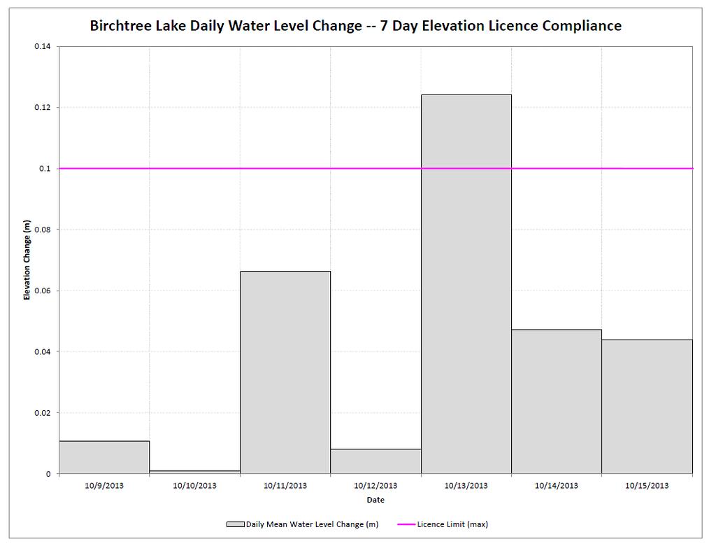
75 360 Portage Ave (16) Winnipeg Manitoba Canada R3C 0G8 Telephone / N o de téléphone : Fax / N o de télécopieur : wvpenner@hydro.mb.ca Our file: _00 Mr. R. Matthews, P. Geo. Manager, Water Use Licensing Manitoba Conservation and Water Stewardship Box Saulteaux Crescent Winnipeg, MB R3J 3W3 Dear Mr. Matthews: WUSKWATIM GENERATING STATION BIRCHTREE LAKE ENVIRONMENT ACT LICENCE MEAN DAILY WATER LEVEL VARIATION ABOVE LICENCE LIMIT On October 13, 2013, the mean daily water level variation on Birchtree Lake was above the licence limit specified in clause 30 (b) of The Environment Act Licence No The Birchtree Lake daily water level change was metres on October 13, 2013 (Figure 1). Clause 30(b) of The Environment Act Licence No limits mean daily water level variations on Birchtree Lake to 0.10 metres under open water conditions. The incident occurred one day after a significant regional rainfall event which we believe caused much of the change. Hydraulic Operations Department is investigating the incident and we will advise you of the outcome. If you have any questions about this matter, please call me at (204) Yours truly, Original signed by: Wesley Penner W.V. Penner, P.Eng. Manager Hydraulic Operations Department MJD/am/ _00.docx
76
77
78
79 360 Portage Ave (16) Winnipeg Manitoba Canada R3C 0G8 Telephone / N o de téléphone : Fax / N o de télécopieur : wvpenner@hydro.mb.ca Our file: _00 Mr. R. Matthews, P. Geo. Manager, Water Use Licensing Manitoba Conservation and Water Stewardship Box Saulteaux Crescent Winnipeg, MB R3J 3W3 Dear Mr. Matthews: WUSKWATIM GENERATING STATION ENVIRONMENT ACT LICENCE BIRCHTREE LAKE MEAN DAILY WATER LEVEL VARIATION ABOVE LICENCE LIMIT On October 13, 2013, the mean daily water level variation on Birchtree Lake was above the licence limit specified in clause 30 (b) of The Environment Act Licence No (Licence). This letter supplements our November 6, 2013 report regarding this incident. The Birchtree Lake daily water level change was metres on October 13 (Figure 1). The licence limits mean daily water level variations on Birchtree Lake to 0.10 metres under open water conditions. The incident occurred one day after a significant regional rainfall event which we believe caused much of the change. Hydraulic modeling also shows that the exceedance was partly a result of the operation of the Wuskwatim Generating Station in response to this rainfall event. Early on October 11, station outflow was reduced to increase the Wuskwatim Lake level which had steadily declined over the previous five days. A major rainfall event over the entire basin began late in the day on October 11 and continued to October 12. Three meteorological stations across the basin each recorded at least 45 mm of rainfall (Figure 2). On October 12, station outflow was increased to halt the rise of the lake level and pass the increased inflow resulting from the rainfall event. The October 11 reduction in station outflow followed by the large rainfall event and subsequent increase in station outflow on October 12 caused the daily water level change on Birchtree Lake to exceed the licence limit by m. Operations to maintain Wuskwatim Lake mean daily and hourly water levels within the licence limits (Figure 3 and 4) during this period caused the violation of the daily water level change limit on Birchtree Lake. If you have any questions about this matter, please call me at
80 Page 2 Yours truly, Original signed by: Wesley Penner W.V. Penner, P.Eng. Manager Hydraulic Operations Department MJD/bwg/ _00.docx Att.
81 Birchtree Lake Daily Average Water Level [m] Figure 1: Wuskwatim Generating Station - Birchtree Lake Daily Water Level Change 01-Oct Oct Oct Oct Oct Birchtree Lake Daily Water Level Change [m] Daily Water Level Change (Absolute) Daily Water Level Change Limit Daily Average Water Level 30-Sep Nov Oct Oct Oct Oct Oct-13 Note: The Birchtree Lake Daily Water Level Change is calculated using Birchtree Lake gauges 05TG701, 05TG707, 05TG746, & 05TG747 The daily water level change limit is equal to 0.1 m in open water conditions (May 1 to October 31) and 0.15 m in winter conditions (November 1 to April 30)
82
83 Figure 2: Precipitation Chart (3 Meteorological Stations)
84
85 Note: Wuskwatim Lake Mean Daily Water Level is calculated using Wuskwatim Lake gauges 05TF006, 05TF771, 05TF772, 05TF774, & 05TF775 Figure 3: Wuskwatim Generating Station - Wuskwatim Lake Mean Daily Water Level Wuskwatim Lake Mean Daily Water Level [m] Upper Limit [ m] Lower Limit [ m] Wuskwatim Lake Daily Mean Water Level Oct Oct Oct Oct Oct-13
86
87 Figure 4: Wuskwatim Generating Station - Wuskwatim Lake Hourly Water Levels Wuskwatim Lake Inidividual Gauges Hourly Water Levels [m] Upper Limit [ m] TF006 05TF774 Lower Limit [ m] TF771 05TF TF /10/ /10/ /10/ /10/ /10/ Wuskwatim Lake Hourly Water Level [m] Wuskwatim Hourly Water Level Upper Limit [ m] Lower Limit [ m] /10/ /10/ /10/ /10/ /10/29
88
89 APPENDIX II WUSKWATIM GENERATING STATION LICENCE IMPLEMENTATION GUIDE FOR WATER LEVELS
90
91 Wuskwatim Power Limited Partnership Wuskwatim Generating Station Licence Implementation Guide for Water Levels Prepared for: Manitoba Water Stewardship 200 Saulteaux Crescent Winnipeg, Manitoba R3J 3W3 Prepared by: Hydraulic Operations Department Manitoba Hydro 820 Taylor Avenue Winnipeg, Manitoba R3C 2P4 On behalf of: Wuskwatim Power Limited Partnership 820 Taylor Avenue Winnipeg, Manitoba R3C 2P4 July 2007 Report No. PS&O 07/03
92
93 Originally Signed by B.W. Giesbrecht Originally Signed by W.V. Penner Originally Signed by B.W. Giesbrecht Originally Signed by T.M. Miles
94
95 Foreword Wuskwatim Power Limited Partnership (WPLP) has been issued licences under the Environment Act and The Water Power Act for the development of the Wuskwatim Generating Project. The WPLP is a limited partnership of which Manitoba Ltd., a wholly owned subsidiary of Manitoba Hydro, is the general partner and Manitoba Hydro and Taskinigahp Power Corporation, wholly owned by Nisichawayasihk Cree Nation, are limited partners. The WPLP has entered in contracts with Manitoba Hydro for the management, construction and operation of the Wuskwatim generating station in accordance with the provisions of the applicable agreements as set out in the Project Development Agreement between Nisichawayasihk Cree Nation and Manitoba Hydro. Consistent with responsibilities set out in these agreements, Manitoba Hydro has prepared this report on behalf of the WPLP. Executive Summary Introduction In collaboration with Manitoba Water Stewardship, Manitoba Hydro prepared this guideline to document a common understanding of the water regime terms of the Wuskwatim licences. Environment Act Licence No and an Interim Water Power Act licence specify operating limits and reporting requirements that must be met for compliance with the licences. As such, this document sets out the mutually understood and agreed to: o calculation methodology to be used for determining critical levels, o protocol for reporting to meet licence requirements, and o manner in which compliance will be defined and assessed. Wuskwatim Lake As required by licence, data from a minimum of three water level gauges will be used to determine the Wuskwatim Lake level. A set of averaging and weighting techniques are employed to remove immediate operational effects and the effects of wind and waves. Birchtree Lake As required by licence, data from a minimum of two water level gauges will be used to calculate the daily change on Birchtree Lake. Weighting and averaging techniques are used to remove the effect of wind and waves. Compliance Compliance with the licence on Wuskwatim Lake will be measured against both hourly water levels and wind-eliminated water levels. In the event that the Birchtree Lake daily change licence constraint is exceeded, a hydraulic model of the Burntwood River will be PS&O 07/03 3
96 used to determine the change attributable to Wuskwatim operations. Compliance with the Environment Act licence will be measured against the model output. Monthly and annual reports will be issued to Manitoba Water Stewardship in accordance with the Environment Act licence. Special compliance reports will be issued as necessitated by deviations from licence conditions. Change Management Revisions to this Implementation Guide are anticipated to accommodate the change from pre-project monitoring to construction to plant operation. Proposed revisions will be discussed with Manitoba Water Stewardship from time to time. Following review and approval of revisions by Manitoba Water Stewardship, a revised copy of this Implementation Guide will be produced and distributed by Wuskwatim Power Limited Partnership. A five year window is included in the Environment Act licence to review the appropriateness of the included water level parameters. This review window recognizes that the licence parameters are based on model simulations and that measured data may differ from what was anticipated. PS&O 07/03 4
97 Table of Contents Foreword... 3 Executive Summary Introduction Definitions Datum Water Levels and Water Level Fluctuations Quality Control Benchmarks Direct water level measurements Gauge readings Quality assurance procedure for water level data Wuskwatim Lake Gauge location criteria Wuskwatim Wind-Eliminated Water Level calculation procedure Hourly averaging and weighting Three-day moving average Birchtree Lake Gauge location criteria Method to determine magnitude of project impacts on Birchtree Lake Daily Change Birchtree Lake Daily Change calculation Wuskwatim operational impact determination Meteorological impacts Non-project hydraulic impacts Compliance Wuskwatim Lake Birchtree Lake Reporting Compliance Reporting Regular Monthly Reporting Regular Annual Reporting Change Management Regular Updates Comprehensive Review Figures Appendix A Water level gauge description sheets Appendix B Water Level Gauge Weighting Factors B.1. Wuskwatim Lake Gauges B.2. Birchtree Lake Gauges PS&O 07/03 5
98
99 1. Introduction 1.1 Definitions For the purposes of this implementation guide, unless the context otherwise requires, the following terms shall have the respective meanings set out below and grammatical variations of such terms shall have corresponding meanings: ASL means above sea level; Controlling Benchmarks means: (a) Manitoba Hydro benchmark BM L20A-1 (85MH2H) for Wuskwatim Lake. This benchmark is a brass cap set in bedrock located along the south shore of Wuskwatim Lake approximately 250 metres northeast of the centre of Wuskwatim Falls. The elevation of this benchmark was established by precise spirit leveling methods from GSC benchmark 69M592 located near Taskinigup Falls. The elevation of benchmark BM L20A-1 is metres, GSC CGVD28, 1969 local adjustment (b) Birchtree Lake benchmarks were established by static GPS methods constrained on GSC benchmarks 69M587 ( metres) located just west of Birchtree Lake at Pipe Lake mine, on 69M575 ( metres) located west of Birchtree Lake along PTH #6 and on Hydro 2 located on the Burntwood River upstream of Opegano Lake. This geodetic control effectively surrounds Birchtree Lake and allows for accurate benchmarks to be established on Birchtree Lake. Birchtree Lake Gauges means the water level gauges established on Birchtree Lake for the purpose of collecting data used in calculating the Birchtree Lake Hourly Water Level; Birchtree Lake Daily Average Water Level means the arithmetic mean of all hourly water levels recorded at the Birchtree Lake Gauges for a calendar day; Birchtree Lake Daily Change means the difference in the Birchtree Lake Daily Average Water Level between one calendar day and the previous calendar day; Wuskwatim Lake Gauges means the water level gauges established on Wuskwatim Lake for the purpose of collecting data used in calculating the Wuskwatim Mean Daily Water Level (with wind and wave effects eliminated); Wuskwatim Hourly Water Level means the weighted average of available readings of water levels recorded from the top of one hour to the top of the following hour at the Wuskwatim Lake Gauges, calculated as set forth in Section 2.2; Wuskwatim Daily Average Water Level means the arithmetic mean of all Wuskwatim Hourly Water Levels for a calendar day; PS&O 07/03 6
100 Wuskwatim Mean Daily Water Level (with wind and wave effects eliminated) means a three day moving mean of the Wuskwatim Daily Average Water Level. 1.2 Datum In accordance with Clause 30(d) of Environment Act Licence No and Section 10.3 of the Wuskwatim Site, Burntwood River Interim Water Power Act licence, water level information for the operation of the Wuskwatim Project is based upon Geodetic Survey of Canada (GS of C), Canadian Government Vertical Datum (CGVD) 1928, 1971 Local Adjustment (also referred to as GS of C CGVD28, 1969 Local Adjustment). 1.3 Water Levels and Water Level Fluctuations All water levels referenced in this implementation guide are to be inferred as measured in terms of elevations ASL, GS of C CGVD Local Adjustment. All water levels and water level fluctuations referenced in this implementation guide are to be inferred as measured excluding the effects of wind and waves. 1.4 Quality Control Benchmarks Vertical control surveys have been performed to establish appropriate local benchmarks around Wuskwatim Lake and Birchtree Lake at hydrometric gauging stations. Wuskwatim Lake benchmarks were established by water level transfer from Controlling Benchmarks using spirit leveling methods and staff gauge readings. These benchmarks are accurate to ± 10mm. Vertical control on Birchtree Lake did not meet the required standards for long term water level monitoring. Therefore, elevations for the new benchmarks were established using static GPS methods from Controlling Benchmarks in the region. The Birchtree Lake benchmarks are accurate to ± 50 mm, a typical error associated with using GPS survey methods Direct water level measurements Field staff will visit the Wuskwatim Lake Gauges and the Birchtree Lake Gauges on a two month cycle as a minimum. Additional site visits will be conducted as necessary to maintain gauge performance. Direct water level measurements are taken during these visits and compared to the level indicated by the water level sensor. Direct water level measurements for lakes of this size are typically accurate to within ±5 mm with the instrument error accounting for ±0.8 mm. PS&O 07/03 7
101 1.4.3 Gauge readings Manitoba Hydro uses pressure transducers to determine water levels at its existing hydrometric gauging stations and at the Wuskwatim Lake Gauges and the Birchtree Lake Gauges. The error in the reading provided by the pressure transducer is ±0.75 mm given the scale setting that is typically used by Manitoba Hydro. The transducers are temperature corrected, however, if the temperature correction malfunctions, the reading can drift between site visits by up to 0.1 metres, although drift of this magnitude is rare. If the technician visiting the site determines that the transducer reading is more than ±5 mm different from the direct water level measured in accordance with Subsection 1.4.2, the transducer is reset to the direct water level measurement. If the transducer reading is less than ±5 mm different from the direct water level measured in accordance with Subsection 1.4.2, no change is made to the transducer setting. 1.5 Quality assurance procedure for water level data Water level data exists in three degrees of quality assurance raw, provisional and final. Raw data is real-time data that has been transmitted from the field. The only level of quality assurance is that built in to the data collection system, described in Section 1.4. This level of data is used in the daily operation of the Wuskwatim Generating Station. This level of data is also reported monthly in accordance with Subsection of this guide. Provisional data is data processed by a qualified data assurance technician who reviews the field data and corrects obvious errors. The data is compared to all available relevant data in the area to verify its accuracy. Final data has been through two levels of review by qualified technicians and a final review by a professional engineer. This data is considered publishable and has met the quality assurance standards of the National Hydrometric Program. This data will be used for annual reporting described in Subsection of this guide PS&O 07/03 8
102 2. Wuskwatim Lake 2.1 Gauge location criteria In accordance with Clause 30(a) of Environment Act Licence 2699, a minimum of three water level gauges will be used in determining the water level of Wuskwatim Lake. Six test locations for the Wuskwatim Lake Gauges, shown in Figure 1, have gauges installed temporarily for the purpose of collecting and analyzing water level data. Detailed gauge descriptions are included in Appendix A. From the six test locations, final locations will be selected for the Wuskwatim Lake Gauges. Final gauge locations will be in spots that exhibit a minimum variation in water level due to wind speed and direction. 2.2 Wuskwatim Wind-Eliminated Water Level calculation procedure Clause 30(a) of Environment Act Licence No and Section 4.2 of the Interim Water Power Act licence place limits on Wuskwatim Lake water levels. Wuskwatim Lake water levels will be influenced by Wuskwatim operations. Water levels will also be affected by local meteorological events and non-project hydraulic effects. Significant local weather impacts can result from heavy precipitation, the movement of high and low pressure cells and large wind events. Non-project hydraulic impacts may result from upstream storage and release of water caused by changing ice conditions, operation of Notigi Control Structure, rapid spring runoff. To properly evaluate the wind-eliminated water level, averaging techniques are used to remove these effects. Small, short-term weather and hydraulic events can be smoothed out using multiple gauges, gauge weighting and a daily average water level. Larger, long-term events require a longer duration averaging technique. For a lake of this size, a three-day moving mean is appropriate. In order to ensure that the Licensee s operations remain within the constraints of its licences, compliance will be measured against both the Wuskwatim Hourly Water Level and the Wuskwatim Mean Daily Water Level (with wind and wave effects eliminated) Hourly averaging and weighting The Wuskwatim Lake Gauges will be set to record spot water levels from which the hourly average water level at each gauge location will be calculated. The hourly average water levels from each of the Wuskwatim Lake Gauges will be used to determine the Wuskwatim Hourly Water Level as shown in Equation 1. The Wuskwatim Hourly Water Level is one measure of compliance with Environment Act Licence 2699 and the Interim Water Power Act licence as discussed in Section 4.1, below. HAWL [1] where = ( W G n n ) n PS&O 07/03 9
103 HAWL = Wuskwatim Hourly Water Level G n = hourly average water level for Wuskwatim Lake Gauge n W n = weighting factor for Wuskwatim Lake Gauge n and Wn = 1 n Weights are assigned in inverse proportion to the standard deviation of each Wuskwatim Lake Gauge s recorded water levels from the Wuskwatim Mean Daily Water Level (with wind and wave effects eliminated). Tables of current weighting factors are included in Appendix B. Weights will be reviewed regularly and a table of current weights will be included in each annual compliance report Three-day moving average As an intermediate step in determining the Wuskwatim Mean Daily Water Level (with wind and wave effects eliminated), the Wuskwatim Daily Average Water Level will be calculated as the arithmetic mean of the Wuskwatim Hourly Water Levels as shown in Equation 2. n HAWLi i= DAWL = 1 n [2] where DAWL = the Wuskwatim Daily Average Water Level HAWL i = the Wuskwatim Hourly Water Level for hour i n = the number of available hourly readings for that calendar day A three-day moving average as shown in Equation 3, will be applied to the Wuskwatim Daily Average Water Level data stream to produce the Wuskwatim Mean Daily Water Level (with wind and wave effects eliminated). WEWL i = DAWL + DAWL i 2 i 1 i 3 + DAWL [3] where WEWL i = Wuskwatim Mean Daily Water Level (with wind and wave effects eliminated) for day i DAWL i = Wuskwatim Daily Average Water Level for day i PS&O 07/03 10
104 3. Birchtree Lake 3.1 Gauge location criteria In accordance with Clause 30(c) of Environment Act Licence 2699, a minimum of two water level gauges will be used in determining the Birchtree Lake Daily Change for the purpose of licence compliance. In addition to Manitoba Hydro gauge 05TG701 already located on Birchtree Lake, three more test locations for the Birchtree Lake Gauges, shown in Figure 2, have gauges installed temporarily for the purpose of collecting and analyzing water level data. Detailed gauge descriptions are located in Appendix A. The final Birchtree Lake Gauges will be the ones that exhibit a minimum variation in water level due to wind speed and direction. 3.2 Method to determine magnitude of project impacts on Birchtree Lake Daily Change Clause 30(b) of Environment Act Licence No limits mean daily water level variations on Birchtree Lake to 0.10 metres under open water conditions and 0.15 metres under winter conditions. Water level changes on Birchtree Lake will be affected by Wuskwatim Generating Station operations. Water level changes are also influenced by local meteorological events and by non-project hydraulic effects. The Birchtree Lake Daily Change is calculated using the method described in which attempts to eliminate the effect of wind-driven waves. If the Birchtree Lake Daily Change exceeds the limits in Clause 30(b), hydraulic modeling will be completed to estimate the project impact and meteorological and non-project hydraulic impacts will be assessed Birchtree Lake Daily Change calculation Wind and wave effect elimination will be accomplished by calculating a weighted daily average of the water levels recorded by the Birchtree Lake Gauges as shown in Equations 4 and 5. BL = W n BG n [4] n where: BL = Birchtree Lake hourly water level W n = weighting factor for Birchtree Lake Gauge n BG n = hourly average water level for Birchtree Lake Gauge n and Wn = 1 n m BLi i= BLDA = 1 [5] m PS&O 07/03 11
105 where: BLDA = Birchtree Lake Daily Average Water Level BL i = Birchtree Lake hourly water level for hour i m = the number of available hourly readings for that calendar day Weights are assigned in inverse proportion to the standard deviation of each Birchtree Lake Gauge s recorded water levels from the Birchtree Lake Daily Average Water Level. Tables of current weighting factors are included in Appendix B. Weights will be reviewed regularly and a table of current weights will be included in each annual compliance report. The Birchtree Lake Daily Change will be calculated as the absolute difference in Birchtree Lake Daily Average Water Level between that calendar day and the previous calendar day as shown in Equation 6. BLDC [6] j = BLDAj BLDAj 1 where: BLDC j = Birchtree Lake Daily Change for calendar day j BLDAj = the Birchtree Lake Daily Average Water Level for calendar day j Wuskwatim operational impact determination As part of the preparation of the Environmental Impact Statement for the Wuskwatim Generating Station, a hydraulic model was developed for the Burntwood River from Wuskwatim Generating Station to First Rapids. In the event that the Birchtree Lake Daily Change exceeds 0.10 metres under open water conditions or 0.15 metres under winter conditions, such a model will be used to determine the magnitude of the Birchtree Lake Daily Change that is attributable to Wuskwatim Generating Station operations. Actual Wuskwatim outflows preceding such an event will be used as the input hydrograph for the model. The model output will show the impact of Wuskwatim operations on the water level changes recorded on Birchtree Lake Meteorological impacts Local weather can cause an impact on the Birchtree Lake Daily Change that is not attributable to Wuskwatim Generating Station operations. Local precipitation can result in a rapid rise of Birchtree Lake water level. The passage of pressure cells can temporarily raise or lower the lake level. Large wind events may produce an effect on water levels that cannot be removed using the weighting technique described in Subsection Local precipitation data is available from the Environment Canada weather station at Thompson Airport, the Manitoba Hydro weather station at Wuskwatim Generating Station and the Manitoba Hydro weather station at Birchtree Lake. These same weather stations provide atmospheric pressure data and wind speed and direction data. An estimate of the magnitude of the meteorological impact on the Birchtree Lake PS&O 07/03 12
106 Daily Change will be made using the model when the Birchtree Lake Daily Change exceeds the licence limit Non-project hydraulic impacts Hydraulic impacts caused by factors other than Wuskwatim Generating Station operations can impact the Birchtree Lake Daily Change. Such factors include but are not limited to varying upstream storage and release of water caused by ice conditions, varying ice conditions at Manasan Control Structure, operation of the Manasan control structure fuse plug and rapid spring runoff. An estimate of the magnitude of such an impact on the Birchtree Lake Daily Change will be made using the model when the Birchtree Lake Daily Change exceeds the licence limit. PS&O 07/03 13
107 4. Compliance 4.1 Wuskwatim Lake Clause 30(a) of Environment Act Licence No states that the Licensee shall operate the Development within the following parameters: maintain the mean daily water level on Wuskwatim Lake (wind and wave effects eliminated) between meters and meters Above Sea Level (ASL), as determined by measurements from a minimum of three water level monitoring stations on Wuskwatim Lake Section 4.2 of the Wuskwatim Interim Water Power Act licence states that: The Licensee shall not raise the headwaters of its development above an elevation of metres ASL as measured on Wuskwatim Lake, except as ordered by the Minister under Clause 72(b) of the Water Power Regulation or as fixed by the Minister under Clause 72(c) of the Water Power Regulation. The forebay level shall be in compliance with the upper limit described above if: 1. The Wuskwatim Mean Daily Water Level (with wind and wave effects eliminated) does not exceed metres, and 2. The Wuskwatim Hourly Water Level does not exceed metres more than two times for two consecutive hours each time in any 24 hour period. The forebay level shall be in compliance with the lower limit described above if: 1. The Wuskwatim Mean Daily Water Level (with wind and wave effects eliminated) does not recede below metres, and 2. The Wuskwatim Hourly Water Level does not recede below metres more than two times for two consecutive hours each time in any 24 hour period. 4.2 Birchtree Lake Clause 30(b) of Environment Act Licence No states that the Licensee shall operate the Development within the following parameters: maintain mean daily water levels on Birchtree Lake such that the daily water level variations shall be less than 0.10 meters and 0.15 meters in open water and winter conditions (wind and wave effects eliminated) respectively. Any exceptions to these fluctuations shall be reported within one week to Manitoba Water Stewardship For the purposes of licence compliance, open water will refer to the period from May 1 to October 31 and winter will refer to the period from November 1 to April 30. The Birchtree Lake Daily Change shall be deemed to be in compliance when: 1. The Birchtree Lake Daily Change is below these seasonal limits, or 2. The Birchtree Lake Daily Change is above these seasonal limits but the change attributable to Wuskwatim Generating Station is below these seasonal limits. PS&O 07/03 14
108 4.3 Reporting Compliance Reporting In the event that the Wuskwatim Generating Station forebay level is not in compliance with the licence limits as described in Section 4.1 above, notification shall be made to Manitoba Water Stewardship within one week of the incident. A follow-up report on causes contributing to the event and changes to operations, if any are needed to prevent such an event in the future, will be provided to Manitoba Water Stewardship. When the Birchtree Lake Daily Change exceeds the open water or winter limit, notification shall be made to Manitoba Water Stewardship within one week of the incident in accordance with Clause 30(b) of Environment Act Licence No A follow-up report containing the modeled Wuskwatim-based contribution to the Birchtree Lake Daily Change and a discussion of other factors affecting the Birchtree Lake Daily Change shall be provided to Manitoba Water Stewardship Regular Monthly Reporting Clause 33 of Environment Act Licence No states that: The Licensee shall report, to Manitoba Water Stewardship, on a monthly and annual basis, the water levels monitored pursuant to Clauses 30 (a) and (c) of this Licence including other relevant station and related system operating characteristics. These reports shall also be provided to the Nelson House Resource Management Board, all communities on the Manitoba Hydro Churchill River Diversion Augmented Flow Program notification list and posted on the Manitoba Hydro web site. Monthly water level reports will be provided in accordance with Clause 33 of Environment Act Licence No These reports will use raw data from the Wuskwatim Lake Gauges and the Birchtree Lake Gauges. The reports will contain the Wuskwatim Hourly Water Level and the Wuskwatim Mean Daily Water Level (with wind and wave effects eliminated) calculated in accordance with Section 2.2 and the Birchtree Lake Daily Change calculated in accordance with Subsection Regular Annual Reporting An annual water level report for each calendar year will be provided in accordance with Clause 33 of Environment Act Licence No This report will use final data from the Wuskwatim Lake Gauges and the Birchtree Lake Gauges. The report will contain the final Wuskwatim Hourly Water Level, the final Wuskwatim Mean Daily Water Level (with wind and wave effects eliminated) and the final Birchtree Lake Daily Change. The annual report will also contain any compliance reports issued in that year. Due to the quality assurance processing time, this report will be issued by June 1 of the following year. PS&O 07/03 15
109 5. Change Management 5.1 Regular Updates Revisions to this Implementation Guide are anticipated to accommodate the change from pre-project monitoring to construction to plant operation. Proposed revisions to this Implementation Guide will be reviewed with Manitoba Water Stewardship from time to time. Following review and approval of revisions by Manitoba Water Stewardship, a revised copy of this Implementation Guide will be produced and distributed by Wuskwatim Power Limited Partnership. 5.2 Comprehensive Review Clause 34 of Environment Act Licence No states that: The Licensee shall at the commencement of the operation of the Development and for a period of fiver years, unless otherwise directed by the Minister, monitor daily water level variations and the frequency and magnitude of exceedances for the purpose of confirming the appropriateness of the parameters prescribed in Clause 30 of this Licence or the need for adjustments to reflect local hydrological conditions. The limits placed on water level and water level fluctuations in Environment Act Licence No were based on hydraulic modeling results. This review period provided in Clause 34 was established to corroborate the modeling results with data collected after the generating station becomes operational. At the start of year four of Wuskwatim operation, a licence parameter review process will be initiated by Wuskwatim Power Limited Partnership in collaboration with Manitoba Water Stewardship. PS&O 07/03 16
110
111 Figures PS&O 07/03 17
112
113 Appendix A Water level gauge description sheets PS&O 07/03 19
114
115
116


117 Wuskwatim Lake Site #5 Number: 05TF771 Name: Wuskwatim Lake Site #5 DCP Id: Drainage Area (km2): Latitude: 55 o Longitude: -98 o Operator: Manitoba Hydro, Thompson Established: September 2005 Location: On the SE side of Wuskwatim Lake on a small island approx. 3.5 km S of the exit. Equipment: A Campbell Scientific CR10X data logger, firmware version 1.21, with an SDI-12 Keller pressure transducer in a Campbell Scientific fiberglass enclosure. Solar panel and an external 12 volt gel cell battery in a cooler. Datum: GSC CGVD Manitoba Hydro local adjustment Bench Marks: 05MH52 - Elevation m. A Manitoba Hydro brass cap set in bedrock near water s edge marked with a 3/8 diameter rebar. It is approx m NW of hilti bolt 5-2 and 0.65 m SE of hilti bolt Elevation m. A Manitoba Hydro brass cap set in bedrock near water s edge. Brass cap is 11.9 m W from DCP and marked with a 5/8 diameter rebar. Brass cap is 24.1 m SW of hilti bolt Elevation m. A hilti bolt drilled into bedrock near water s edge and marked with a flagged tripod 7.6 m from NE edge of the island and 0.65 m NW of BM 05MH52. Metering: Access: Helicopter and boat. Station Status: Active Additional Information: Source file to PDF: Source file last modified: Compiled By: A.L. Janier Checked By: Manitoba Hydro. All Rights Reserved. This document is prepared solely for the internal operations and requirements of Manitoba Hydro. Any copy, reproduction or derivative of this document from its original source at Manitoba Hydro cannot be assumed current, accurate or useful. For any questions regarding this document, its accuracy, or otherwise, contact Hydrometric Surveys, Hydraulic Engineering & Operations, before use.
118 Wuskwatim Lake Site #3 Number: 05TF772 Name: Wuskwatim Lake Site #3 DCP Id: Drainage Area (km2): Latitude: 55 o Longitude: -98 o Operator: Manitoba Hydro, Thompson Established: September 2005 Location: At the entrance to Wuskwatim Lake on the NW shore at the old fish plant site. Datum: GSC CGVD Manitoba Hydro local adjustment Bench Marks: 05MH73 Master - Elevation m. A Manitoba Hydro brass cap stamped 05MH73 set in bedrock near water s edge. Brass cap is 12.2 m NE from DCP and approx. 2 m SW of hilti bolt and marked with a 5/8 diameter rebar Elevation m. A hilti bolt drilled into bedrock near water s edge on the edge of the same rock outcrop as BM 05MH73 and approx. 2 m NE of BM 05MH73. Equipment: A Campbell Scientific CR10X data logger, firmware version 1.21, with an SDI-12 Keller pressure transducer in a Campbell Scientific fiberglass enclosure. Solar panel and an external 12 volt gel cell battery in a cooler. Metering: Access: Helicopter and boat. Station Status: Active Additional Information: Shef Codes: TW, HG, ZT, VB Source file to PDF: Source file last modified: Compiled By: A.L. Janier Checked By: Manitoba Hydro. All Rights Reserved. This document is prepared solely for the internal operations and requirements of Manitoba Hydro. Any copy, reproduction or derivative of this document from its original source at Manitoba Hydro cannot be assumed current, accurate or useful. For any questions regarding this document, its accuracy, or otherwise, contact Hydrometric Surveys, Hydraulic Engineering & Operations, before use.
119 Wuskwatim Lake Site #4 Number: 05TF773 Name: Wuskwatim Lake Site #4 DCP Id: Drainage Area (km2): Latitude: 55 o Longitude: -98 o Operator: Manitoba Hydro, Thompson Established: August 2005 Location: On a point of land on the W shore of Wuskwatim Lake NW of the exit. Datum: GSC CGVD Manitoba Hydro local adjustment Bench Marks: 05MH82 (4-2) Master - Elevation m. A Manitoba Hydro brass cap stamped 05MH82 set in bedrock near water s edge. Brass cap is 11.0 m SE from DCP marked with a 3/8 diameter rebar and is 0.25 m N of hilti bolt Elevation m. A hilti bolt drilled into bedrock near water s edge. Hilti bolt is 11.0 m SE from DCP and marked with a 3/8 diameter rebar 0.25 m S of BM 05MH82. Equipment: A Campbell Scientific CR10X data logger, firmware version 1.21, with an SDI-12 Keller pressure transducer in a Campbell Scientific fiberglass enclosure. Solar panel and an external 12 volt gel cell battery in a cooler. Metering: Access: Helicopter and boat. Station Status: Active Additional Information: Source file to PDF: Source file last modified: Compiled By: A.L. Janier Checked By: Manitoba Hydro. All Rights Reserved. This document is prepared solely for the internal operations and requirements of Manitoba Hydro. Any copy, reproduction or derivative of this document from its original source at Manitoba Hydro cannot be assumed current, accurate or useful. For any questions regarding this document, its accuracy, or otherwise, contact Hydrometric Surveys, Hydraulic Engineering & Operations, before use.
120 Wuskwatim Lake Site #2 Number: 05TF774 Name: Wuskwatim Lake Site #2 DCP Id: Drainage Area (km2): Latitude: 55 o Longitude: -98 o Operator: Manitoba Hydro, Thompson Established: August 2005 Location: On N shore of Wuskwatim Lake approx. 3 km E of the inlet and approx. 3.5 km N of exit. Datum: GSC CGVD Manitoba Hydro local adjustment Bench Marks: 05MH74 Master - Elevation m. A Manitoba Hydro brass cap set in bedrock near water s edge. Brass cap is 15.2 m SW from the DCP marked with a 5/8 diameter rebar and is 16 cm N of hilti bolt Elevation m. A flagged hilti bolt, drilled in to bedrock near water s edge marked with a 0.05 m diameter flagged poplar tree 15.2 m SW of the DCP and 0.16 m S of the BM 05MH74. Equipment: A Campbell Scientific CR10X data logger, firmware version 1.21, with an SDI-12 Keller pressure transducer in a Campbell Scientific fiberglass enclosure. Solar panel and an external 12 volt gel cell battery in a cooler. Metering: Access: Helicopter and boat. Station Status: Active Additional Information: Source file to PDF: Source file last modified: Compiled By: A.L. Janier Checked By: Manitoba Hydro. All Rights Reserved. This document is prepared solely for the internal operations and requirements of Manitoba Hydro. Any copy, reproduction or derivative of this document from its original source at Manitoba Hydro cannot be assumed current, accurate or useful. For any questions regarding this document, its accuracy, or otherwise, contact Hydrometric Surveys, Hydraulic Engineering & Operations, before use.

121 Wuskwatim Lake Site #1 Number: 05TF775 Name: Wuskwatim Lake Site #1 DCP Id: Drainage Area (km2): Latitude: 55 o Longitude: -98 o Operator: Manitoba Hydro, Thompson Established: August 2005 Location: On the SE shore of Wuskwatim Lake approx. 1.5 km NE of Wuskwatim Lake outlet. Datum: GSC CGVD Manitoba Hydro local adjustment Bench Marks: 05MH83 Master - Elevation m. A Manitoba Hydro brass cap set in a bedrock outcrop near water s edge marked with 3/8 diameter rebar and a flagged tripod. The brass cap is 8.2 m W of the DCP 0.2 m NE of the hilti bolt and 2 m W of an eroded bank Elevation m. A hilti anchor bolt drilled into bedrock near water s edge marked with a flagged tripod. The hilti bolt is 0.2 m SW of BM 05MH83 and 8.2 m WNW of the DCP. Equipment: A Campbell Scientific CR10X data logger, firmware version 1.21, with an SDI-12 Keller pressure transducer in a Campbell Scientific fiberglass enclosure. Solar panel and an external 12 volt gel cell battery in a cooler. Metering: Access: Helicopter and boat. Station Status: Active Additional Information: Source file to PDF: Source file last modified: Compiled By: A.L. Janier Checked By: Manitoba Hydro. All Rights Reserved. This document is prepared solely for the internal operations and requirements of Manitoba Hydro. Any copy, reproduction or derivative of this document from its original source at Manitoba Hydro cannot be assumed current, accurate or useful. For any questions regarding this document, its accuracy, or otherwise, contact Hydrometric Surveys, Hydraulic Engineering & Operations, before use.