Environmental Impact Assessment. GEO: East West Highway (Khevi Ubisa Section) Improvement Project
|
|
|
- Letitia Jackson
- 5 years ago
- Views:
Transcription
1 May 2018 Third Draft GEO: East West Highway (Khevi Ubisa Section) Improvement Project Section F2 of the Khevi Ubisa Shorapani Argveta Road (E60 Highway) Part 6 Appendices A D Prepared by JV IRD Engineering S.R.L. & Spea Engineering S.p.A for the Roads Department of the Ministry of Regional Development and Infrastructure of Georgia and for the Asian Development Bank.
2 This environmental impact assessment is a document of the borrower. The views expressed herein do not necessarily represent those of ADB's Board of Directors, Management, or staff, and may be preliminary in nature. Your attention is directed to the terms of use section on ADB s website. In preparing any country program or strategy, financing any project, or by making any designation of or reference to a particular territory or geographic area in this document, the Asian Development Bank does not intend to make any judgments as to the legal or other status of any territory or area.
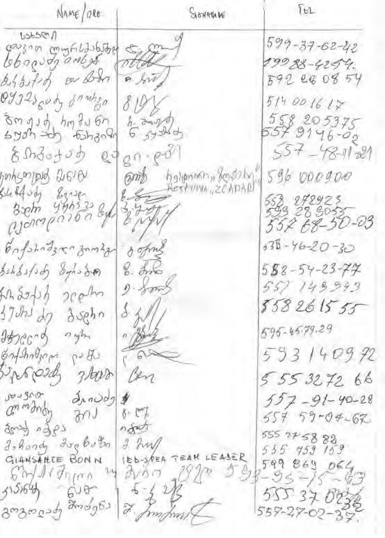
3 APPENDIX A List of Consultation Attendees, June
4 441
5 APPENDIX B Consultation Presentation, June,

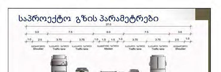
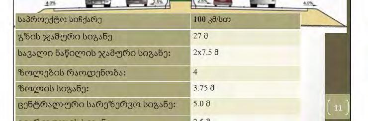
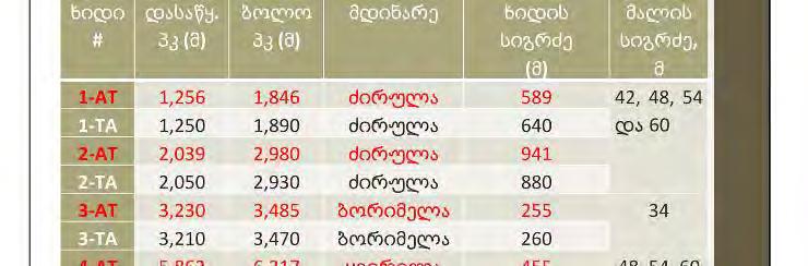
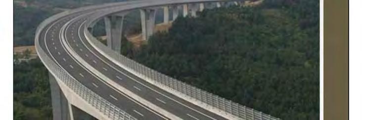
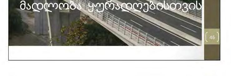
6 Environmental Impact Assessment (EIA) ROADS DEPARTMENT OF GEORGIA Road Corridor Investment Program, Tranche 3 Khevi-Ubisa-Shorapani-Argveta section ADB Loan No GEO Stakeholder Consultations 7 th June 2017 Project Overview The Project is construction of a new road requiring new tunnels, bridges and other structures in order to allow traffic capacity expansion. Construction will be undertaken in difficult topographic and geological conditions without interrupting the traffic flow. Item Description Road Length km Road Width / Number of Lanes 27m/4 lanes Design Speed 100/80 km/h Number of Bridges 77 Number of Tunnels 40 Construction Period 3 years 443


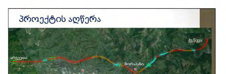
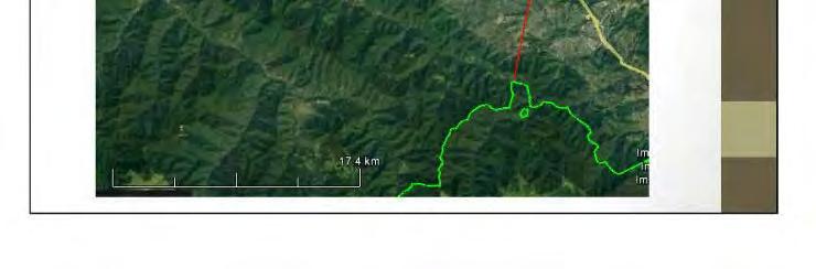
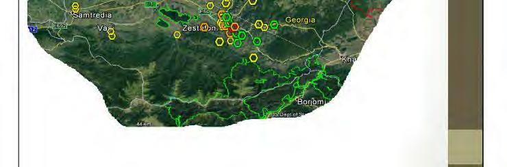
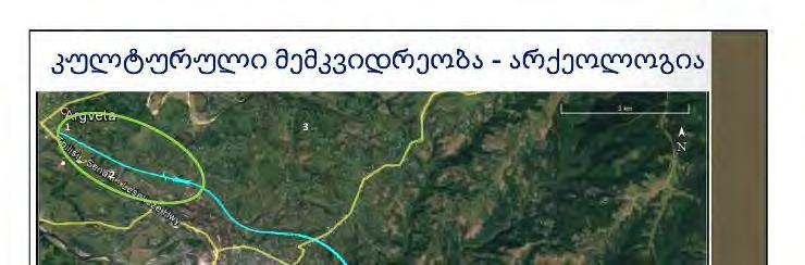
7 Project Location Khevi-Argveta section of E60 Highway starts at the 9 th km west from the existing Rikoti tunnel and ends near village Argveta. The entire section is divided in 3 Lots: F2-F3-F4 1 st Lot: F2 ( from km to km Tot Length = 15.4 km 3 rd Lot: F4 ( from km to km Tot Length = 10.4 km 444


8 2 nd Lot: F3 ( from km to km Tot Length = 10.4 km Need for the Project Transport sector development in Georgia is essential for the achievement of sustainable economic growth, alleviation of poverty and promotion of tourism. Deterioration of transport infrastructure increases the cost of doing business, deters foreign investment, hampers transit traffic growth, and leaves segments of the population out of mainstream economic activities. Georgia's geographical location is at the center of East-West (Black Sea and Caspian Sea) and North-South (between Russia and Turkey) transit routes. Trade with neighboring countries is therefore an important driver of Georgia's economy. 445


9 What is EIA? A process for predicting and assessing the potential environmental and social impacts of a proposed project, evaluating alternatives and designing appropriate mitigation, management and monitoring measures. Consultation Consultation Identify Project Aspects Identify Project Impacts Propose Mitigation Measures Monitor Mitigation Measures Need for Consultations EIA of the Project is required by both Government of Georgia and the Asian Development Bank (ADB) ADB specifically state: The borrower/client will carry out meaningful consultation with affected people and other concerned stakeholders, including civil society, and facilitate their informed participation. For environment category A projects, such consultations will include consultations at the early stage of EIA field work and when the draft EIA report is available during project preparation, and before project appraisal by ADB. 446


 6.")
10 Type of Consultations Second round review draft EIA and comment on the findings of the report First Round Initial discussions regarding the scope of the EIA and potential impacts Other EIA Activities 1. Collection of Baseline Data, including surveys of flora, fauna & rivers. 2. Instrumental monitoring of existing air quality, noise and water quality. 3. Review regulatory requirements. 4. Examine potential alternatives. 5. Assess impacts using tools such as impact matrices and models (air and noise) 6. Prepare of Environmental Mitigation and Monitoring Plans 447
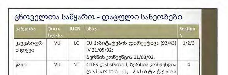
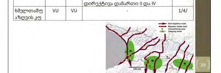
11 Potential Physical Impacts Aspect Air quality Soils Water Quality Climate Change Potential Impact Dust during construction from vehicle movement, batching plants, blasting, tunneling, etc. Vehicle and machinery emissions both during construction and operational phases of the project. Spills and leaks of hazardous liquids. Poor management of borrow pits. Soil Erosion during the operational phase. Spills and leaks of hazardous liquids into rivers. Sedimentation of water ways. Poor disposal of waste water from camp sites. Increased levels of GHGs from vehicle emissions. Impacts of climate change to the Project, e.g. flooding. Potential Biological Impacts Aspect Flora Fauna Protected Areas / Forests Potential Impact Clearance of vegetation for road widening, borrow pits, construction camps and access roads. Illegal cutting of trees. Damage to trees and vegetation during construction. Destruction of habitat for road widening, borrow pits, construction camps and access roads. Blocking migration routes. Degradation of river habitat and associated impacts to fish and other aquatic fauna. Degradation of forests for road widening, borrow pits, construction camps and access roads. 448

12 Potential Socio-economic Impacts Aspect Access Noise Traffic and Safety Waste Cultural Heritage Potential Impact Construction works impeding access to properties and shops / businesses. Elevated noise levels during both construction and operational phases of the project. Construction traffic accidents. Blasting during tunnel excavation and embankment works. Accidents to workers. Accidents involving the public at work sites. Illegal dumping of solid and liquid waste Poor management of hazardous waste leading to pollution of soil, groundwater and health impacts Road encroaching on cemeteries and sites of cultural value Your Thoughts 449

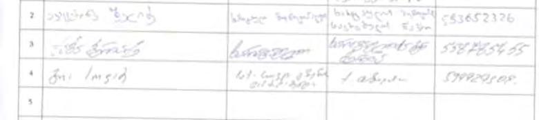
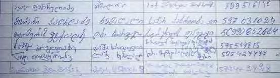
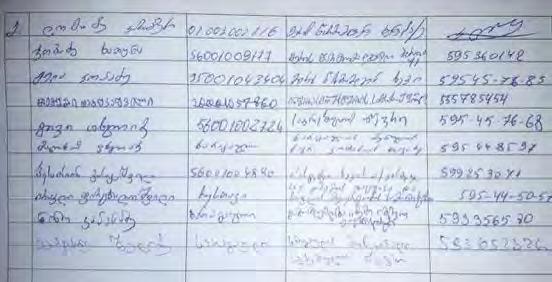
13 APPENDIX C List of Consultation Attendees, February
14 451
15 APPENDIX D Consultation Presentation, January,
16 453
!( ' \"%,&07, 7,&05&,4,.!( /,8\"(,.!( (' 7/) (\"&- /\"0 $,%(!!( 6\"%4 ',#\" - (\"70' \"4 0,.!(!#80%&!%,.\" ' \"%,&07, 7,&05&,4,.!( /,8\"(,.!( /,4,',.!( 4 \" /,&\"%.!*,.,*! 90#!(:!,.,.!( /,(\"+,.; 4!(3- (!")
17 E-60 &"'!() %"*!( +,$!--.!("-/0%"1"#!- "%' $,2 "( "+"*! &0#"3$,2!( &/,#,.* 0.!( 4,) "* - %! 1%0,5)! - 5$.6,$"-"%' $,2 "( &0#"3$,2! (F4) ' "%,&07, 7,&05&,4,.!( /,8"(,." 17!"#$"%!, 2018 /,+$,4%!( &!7"#! 1%0,5)!( ' "%,&07, 7,&05&,4,.!( /,8"(,.!( (' 7/) ("&- /"0 $,%(!!( 6"%4 ',#" - ("70' "4 0,.!(!#80%&!%,." ' "%,&07, 7,&05&,4,.!( /,8"(,.!( /,4,',.!( 4 " /,&"%.!*,.,*! 90#!(:!,.,.!( /,("+,.; 4!(3- (!"; 4 "&(6%, ("70' "4 0,.!( /,#!/$#,.!( 4 " %,30&,#4 ";!,.!( &!9,." "#' "%!/!( (".0* 00 $,%(!"/! ' "("2 $"*!(6!#,.* "
18 455
19 456
!")
!")

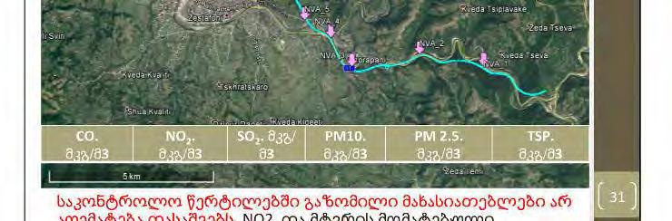
20 !#80%&";!" 1%0,5)!( /,("+,. 7 1%0,5)!( "4'!* &4,."%,0." 8 457
21 458
22 459
23 460

24 461
 - %- *! &,&3$!4 %,0.")
25 ' "%,&07, 7,&05&,4,.!( /,8"(,.!( 1%0;,(!, 7,&05&,4,.!( ("+,,.!,) "1,.!( &!+,4 $!2 17 %"( '- *!(+&0.( '7/ 1%0;,(! ' "%,&0( "%(,.- *! &4 ' 0&"%,0.!( 4 "+"(!"2,." 8!7!3- % ' "%,&07, - B",%7,, #!"4 "' 7,, 6="* 7, 7,&05&,4,.!( /,8"(,.".!0* 0'!- % ' "%,&07, - &;,#"%,- * ("8"%7,, ;+0$,* 2 " ("&="%07, 7,&05&,4,.!( /,8"(,." (0;!"* -,30#0&!3- % ' "%,&07, -4 "("5&,.", 3- * ) - %- *! &,&3$!4 %,0.!( :,' *,.!, (+$. 7,&05&,4,." - "%=08!2! 7,&05&,4,.!( /,&;!%,.!( ' 7,.!( ' "#("79$%" /,&"%.!*,.,*! 90#!(:!,.,.!( ' ") "%,.!( /,&4,',.6 #"%?,#! 7,&05&,4,.!( ' "#("79$%" ' "%,&0(4 ";$!2! &,#,@&,#)! 4 " &0#!) 0%!#'!( 4 "',' &$"
26 463
27 464
28 465
29 466
30 467

 4,.\" &0#!) 0%!#'!")
31 +&"- %! 4 9!( (""2,./! #"+"7! 29 +&"- %4 "&;"$!."%!,%! - +,/! &!"+* 0,.!2 +&"- %!(' "# 4 "(";"$"4 &!"+* 0,.! &."%!,%!( &06=0.". +&"- %!( 4 ",&!(!,.!(' "# 4 "(";"$"4 "(,$, /,(":*,.,*!" 10& (!' "#!( &6$"#,."%!,%,.!( /,5&#". ("3!2 +! 4 "7- () 4,." &0#!) 0%!#'!( ("8- :$,* 7,
32 469
33 470
34 471
 \")!; \"4 \"&!\"#!( 7,' \"$*,#\" (\"/- \"* 0\"; 4 \";- *! (\"+,0.,.!4 \"# 4 \"8!5(!%4 \"?$. 6\".*! (\"+\"* ' \"7%4 \")4 \" 2 :!%! - %2 +0$\"%!")
35 .!0&%"$"* 8,%0$#,." B".!) "),.!( ("30#(,%$";!0 9!%,.- *,." -."#! &03*, 4 "+"(!",." 1 6!2,*! #- (+!( ("+,0.!4 "# 4 "8!5(!%4 " 3"3*!( +, (2 :!%!, "+"* ' "7%4 "), %0&,*!; /,&090.!* &!6!( #"3$,2 7, "4 '!* 0.%!$,.( +,* 0$#- %"4 "5$2?"%' - *!. 4 "."*! 2 70&!,%"4 ("+,/,;$*!*! B".!) ")!; "4 "&!"#!( 7,' "$*,#" ("/- "* 0"; 4 ";- *! ("+,0.,.!4 "# 4 "8!5(!%4 "?$. 6".*! ("+"* ' "7%4 ")4 " 2 :!%! - %2 +0$"%! 3 70&!,%"4 ("+,/,;$*!*! B".!) ")!". "4 "&!"#!( 7,' "$*,#" ' "&0!+"),." ("50#*!( :0$,."(" 4 " ) =!(?,+$"/!; "% 4 "8!5(!%4 " &;,#"%!( "%;,%2! 4 ";- *! ("+,0.". &(' "$(! )!1!( B".!) ")! ' "#$!2 "%,.- *!" &4!#"%!(1!%" >"*,./! 4 "("+*,.,.!( &"+* 0.* " ";- *! ("+,0.,.!4 "# ' $+$4,." 3"3"*! (&0&6!8"%!). ' "$%;,*,.- *!"!#$"7!- %!."* "+0$"#! &;,#"%, =$"$!* 6$%!* ". 6 (!&!#4!( ="#,.!, $,#"+!, +,+!*!(."9,.!. 2 "$!(- 8"* "4 '!*,.(!=,#,.,# (":0$%"4 ; 4 ";- *! ("+,0.,.! - ("/- "* 0 4 "."*! 4 "."*! 4 "."*! &"9"*! 472
36 473
37 474

38 475
39 476
 7,() \"80#! (3& 6.0 11.0) 5$.(\"5\"%\" (3& 11.0 12.0) \"%' $,2 \" (3& 13.0 15.0) ' \"(\"($*,*,.")
40 1%0,5)!( 70#"/! &0+$,4 %!*! 4 "("+*,.- *! 1- #5),.! 5$.6,$" (3& 0) /0%"1"#! (3& ) 7,() "80#! (3& ) 5$.("5"%" (3& ) "%' $,2 " (3& ) ' "("($*,*,.! 477
41 478
42 479