Public Notice. Applicant: Texas Central Railroad, LLC Project No.: SWF Date: December 22, 2017
|
|
|
- Estella Stafford
- 5 years ago
- Views:
Transcription

1 Public Notice Applicant: Texas Central Railroad, LLC Project No.: SWF Date: December 22, 2017 The purpose of this public notice is to inform you of a proposal for work in which you might be interested. It is also to solicit your comments and information to better enable us to make a reasonable decision on factors affecting the public interest. We hope you will participate in this process. Regulatory Program Since its early history, the U.S. Army Corps of Engineers has played an important role in the development of the nation's water resources. Originally, this involved construction of harbor fortifications and coastal defenses. Later duties included the improvement of waterways to provide avenues of commerce. An important part of our mission today is the protection of the nation's waterways through the administration of the U.S. Army Corps of Engineers Regulatory Program. Section 10 The U.S. Army Corps of Engineers is directed by Congress under Section 10 of the Rivers and Harbors Act of 1899 (33 USC 403) to regulate all work or structures in or affecting the course, condition or capacity of navigable waters of the United States. The intent of this law is to protect the navigable capacity of waters important to interstate commerce. Section 404 The U.S. Army Corps of Engineers is directed by Congress under Section 404 of the Clean Water Act (33 USC 1344) to regulate the discharge of dredged and fill material into all waters of the United States, including wetlands. The intent of the law is to protect the nation's waters from the indiscriminate discharge of material capable of causing pollution and to restore and maintain their chemical, physical and biological integrity. Contact Name: Mr. Darvin Messer Phone Number: (817)
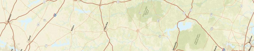
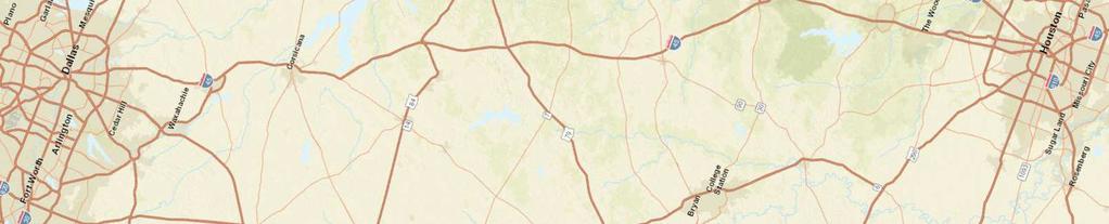
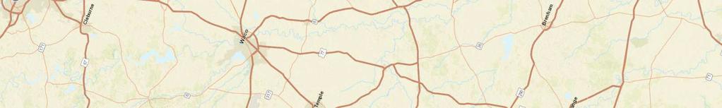
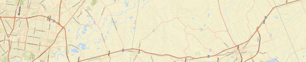
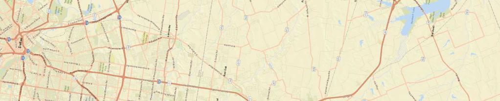
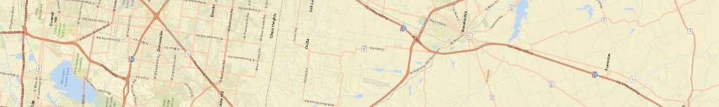
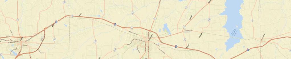
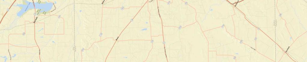
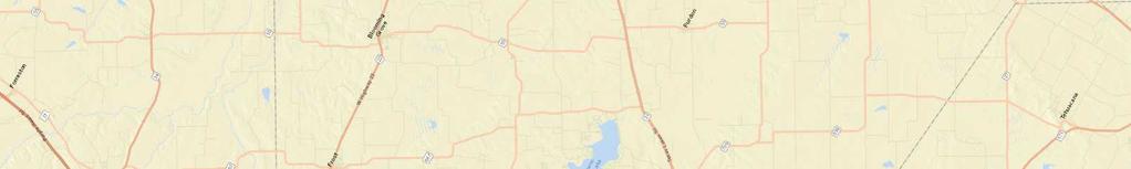
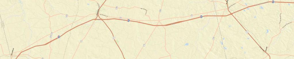
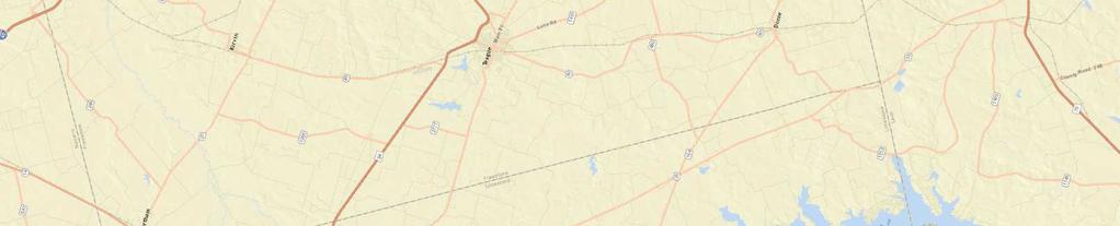
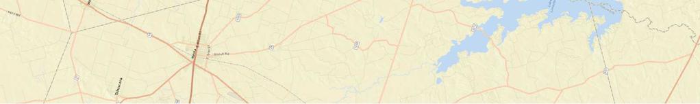
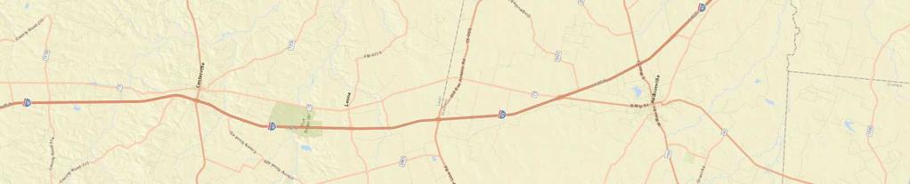
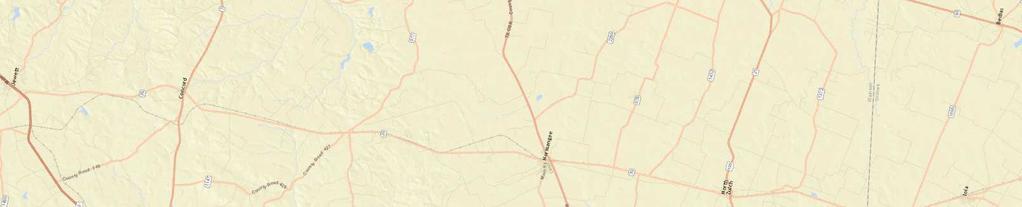
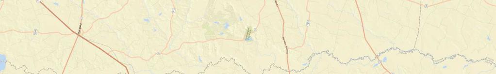
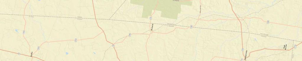
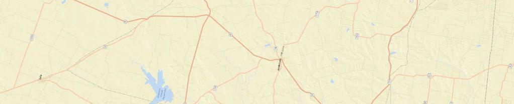
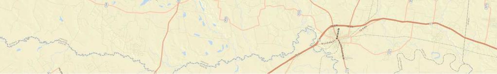
2 JOINT PUBLIC NOTICE U.S. ARMY CORPS OF ENGINEERS, FORT WORTH DISTRICT AND TEXAS COMMISSION ON ENVIRONMENTAL QUALITY SUBJECT: Application for a Department of the Army Permit under Section 404 of the Clean Water Act (CWA) and Section 10 of the Rivers and Harbors Act of 1899, and for water quality certification under Section 401 of the CWA to discharge dredged or fill material into waters of the United States and conduct activities in, or affecting, navigable waters of the United States associated with the construction of the Dallas to Houston High Speed Rail (DHHSR) Project in Dallas, Ellis, Navarro, Freestone, Limestone, Leon, Madison and Grimes counties in Texas. Project related activities proposed in Waller and Harris counties in Texas are within the USACE Galveston District and are disclosed in Public Notice SWG which can be found on their website: The Federal Railroad Administration (FRA), as lead Federal agency, is preparing an Environmental Impact Statement (EIS) for the proposed DHHSR. The Draft EIS and other project related information can be found on their website: The USACE accepted FRA s invitation to become a Cooperating Agency in the development of the EIS for the project. APPLICANT: Mr. Carlos F. Aguilar, CEO Texas Central Railroad, LLC 1409 South Lamar Street, Suite 1022 Dallas, Texas APPLICATION NUMBER: SWF DATE ISSUED: December 22, 2017 LOCATION: The proposed DHHSR alignment would be located as shown on the attached Pages 1-6 of 6 in Dallas, Ellis, Navarro, Freestone, Limestone, Leon, Madison and Grimes counties in Texas. The proposed Dallas Station would be located approximately at coordinates: Latitude North and Longitude West on the Dallas, TX, 7.5-minute USGS quadrangle map. The proposed project would extend from this northern terminus on the southeast side of Dallas a distance of approximately 240 miles to its proposed northern terminus on the northwest side of Houston. Of this overall proposed project alignment length, approximately 189 miles are within the Fort Worth District in the counties listed above and is the subject of this Public Notice. The remaining approximately 51 miles of the proposed project are located in Waller and Harris counties within the Galveston District and are disclosed in detail in their Public Notice at the website referenced above.
3 Due to the length of the proposed alignment, it is not feasible for detailed mapping to be attached to this Public Notice. The attached Pages 2-6 of 6 are key maps of the counties along the proposed alignment that provide reference map numbers for detailed plan view maps of the proposal that can be accessed at this website: Rail-Project/ The proposed project would be located in the following USGS Hydrologic Units: (Upper Trinity), (Chambers), (Richland), (Lower Trinity- Tehuacana), (Navasota), (Lower Trinity-Kickapoo), (West Fork- San Jacinto) and (Spring). OTHER AGENCY AUTHORIZATIONS: State Water Quality Certification, FRA Rule of Particular Applicability PROJECT DESCRIPTION: The applicant s stated purpose for the proposed investor-owned project is to construct and operate an efficient, reliable and safe alternative mode of transportation between the cities of Dallas and Houston, Texas, that would add transportation capacity in the corridor to meet increasing travel demands and provide an additional travel mode. The proposed investor-owned project consists of the construction of approximately 240 miles of rail line extending from Dallas County to Harris County, Texas. A single terminal station is proposed in both Dallas and Houston and a single intermediate station, the Brazos Valley Station, is proposed near Roans Prairie in Grimes County. The proposed project would consist of the construction of two parallel rail lines, related maintenance and utility facilities, and temporary staging/construction areas necessary for project logistics. These activities would be contained within a variable width right-of-way and/or easements. The proposed project route would allow travel times of approximately 90 minutes between the terminal cities with trains capable of traveling at speeds up to 205 miles per hour in a sealed corridor. The entire proposed project alignment would be designed to provide for grade separated rail and road crossings. A substantial portion of the rail line (approximately 60%) is proposed to be constructed as elevated viaduct (pier and beam) to minimize environmental, drainage and property impacts and to provide access across the alignment. The applicant identified dozens of potential alternatives for analysis utilizing a multi-level, two stage screening process that resulted in a group of end-to-end alignment alternatives that were presented to the Federal agencies and the public during respective scoping processes as part of the EIS being developed by the FRA. Subsequently, six end-to-end practicable alternatives were carried forward for further evaluation and their analysis is being reviewed by USACE to determine compliance with Section 404(b)(1) Guidelines for Specification of Disposal Sites for Dredged and Fill Material. The applicant has made further efforts to avoid and minimize impacts to waters of the U.S. (WOUS) where appropriate and practicable, including making minor shifts to the proposed alignment to avoid and/or minimize impacts to wetlands and streams (i.e.- avoiding alignment that parallels stream segments). Additionally, approximately half of the
4 proposed alignment parallels existing electric power transmission lines, roadways and/or other utility easements which minimizes impacts due to access and/or fragmentation. Following these efforts to avoid and minimize impacts to WOUS, the applicant s preferred alignment alternative for the proposed project would result in the following unavoidable impacts to WOUS: Impact duration Subtotal Aquatic Resource type Temporary Permanent Ephemeral stream 30,256 lf (3.01 ac) 48,464 lf (4.82 ac) 78,720 lf (7.83 ac) Intermittent stream 18,691 lf (5.07 ac) 22,656 lf (4.99 ac) 41,347 lf (10.06 ac) Perennial stream 5,173 lf (3.26 ac) 8,663 lf (10.98 ac) 13,836 lf (14.24 ac) STREAM TOTAL 54,120 lf (11.34 ac) 79,783 lf (20.79 ac) 133,903 lf (32.13 ac) Ponds ac ac ac Emergent wetland 9.24 ac ac ac Forested* wetland ac** ac GRAND TOTAL ac ac ac Linear feet = lf; Acres = ac; *includes scrub-shrub; **includes permanent conversion to emergent wetlands It should be noted that these quantities are further refined and differ from numbers disclosed in FRA s DEIS due to extensive efforts in field investigation and verification of jurisdictional status of aquatic resources by USACE. Detailed project plan sheets indexed on attached Pages 1-6 of 6 which include WOUS locations are accessible here: Rail-Project/ Additionally, typical design drawings of various project elements such as cut/fill, culvert, viaduct and design layout are included. The proposed project alignment crosses a segment of the Trinity River near downtown Dallas designated as a Section 10 of the Rivers and Harbors Act waterbody and is being evaluated accordingly. A copy of the complete application is also available for review at the USACE Fort Worth Regulatory Division in Room 3A37 of the Federal Building at 819 Taylor Street in Fort Worth between 8:00 A.M. and 3:30 P.M., Monday through Friday. Compensatory mitigation for aquatic resource impacts is required for single and complete crossings of WOUS that exceed 0.1 acre of wetland and/or 300 linear feet of stream. To offset unavoidable adverse impacts to waters of the U.S. at these crossings, the applicant proposes to 1) purchase in-kind credits from an approved mitigation bank for impacts to WOUS within the Upper Trinity watershed (HUC ); and 2) fulfill all remaining necessary mitigation requirements through the development of a permittee-responsible mitigation plan utilizing a watershed approach. PUBLIC INTEREST REVIEW FACTORS: This application will be reviewed in accordance with 33 CFR , the Regulatory Program of the U. S. Army Corps of Engineers (USACE),
5 and other pertinent laws, regulations, and executive orders. Our evaluation will also follow the guidelines published by the U. S. Environmental Protection Agency pursuant to Section 404 (b)(1) of the CWA. The decision whether to issue a permit will be based on an evaluation of the probable impact, including cumulative impact, of the proposed activity on the public interest. That decision will reflect the national concerns for both protection and utilization of important resources. The benefits which reasonably may be expected to accrue from the proposal must be balanced against its reasonably foreseeable detriments. All factors which may be relevant to the proposal will be considered, including its cumulative effects. Among the factors addressed are conservation, economics, aesthetics, general environmental concerns, wetlands, historic properties, fish and wildlife values, flood hazards, floodplain values, land use, navigation, shore erosion and accretion, recreation, water supply and conservation, water quality, energy needs, safety, food and fiber production, mineral needs, considerations of property ownership, and, in general, the needs and welfare of the people. The USACE is soliciting comments from the public; federal, state, and local agencies and officials; Indian Tribes; and other interested parties in order to consider and evaluate the impacts of this proposed activity. Any comments received will be considered by the USACE in determining whether to issue, issue with modifications, or conditions, or deny a permit for this proposal. To make this decision, comments are used to assess impacts on endangered species, historic properties, water quality, general environmental effects, and the other public interest factors listed above. Comments are used in the preparation of an Environmental Assessment and/or an Environmental Impact Statement pursuant to the National Environmental Policy Act. Comments are also used to determine the need for a public hearing and to determine the overall public interest of the proposed activity. STATE WATER QUALITY CERTIFICATION: This project would result in a direct impact of greater than three acres of waters of the state or 1,500 linear feet of streams (or a combination of the two is above the threshold), and as such would not fulfill Tier I criteria for the project. Therefore, Texas Commission on Environmental Quality (TCEQ) certification is required. Concurrent with USACE processing of this Department of the Army application, the TCEQ is reviewing this application under Section 401 of the Clean Water Act, and Title 30, Texas Administrative Code Section to determine if the work would comply with State water quality standards. By virtue of an agreement between the USACE and the TCEQ, this public notice is also issued for the purpose of advising all known interested persons that there is pending before the TCEQ a decision on water quality certification under such act. Any comments concerning this application may be submitted to the Texas Commission on Environmental Quality, 401 Coordinator, MSC-150, P.O. Box 13087, Austin, Texas The public comment period extends 30 days from the date of publication of this notice. A copy of the public notice with a description of the work is made available for review in the TCEQ's Austin Office. The TCEQ may conduct a public meeting to consider all comments concerning water quality if requested in writing. A request for a public meeting must contain the following information: the name, mailing address, application number, or other recognizable reference to the application; a brief description of the interest of the requestor, or of persons represented by 4
6 the requestor; and a brief description of how the application, if granted, would adversely affect such interest. ENDANGERED AND THREATENED SPECIES: The USACE has reviewed the U.S. Fish and Wildlife Service's latest published version of endangered and threatened species to determine if any may occur in the project area. The proposed project would be located in Dallas, Ellis, Navarro, Freestone, Limestone, Leon, Madison and Grimes counties where the Houston toad (Bufo houstonensis), large-fruited sand verbena (Abronia macrocarpa), Navasota ladies -tresses (Spiranthes parksii), whooping crane (Grus Americana), Least tern (Sterna antillarum), Goldencheeked warbler (Dendroica chrysoparia), piping plover (Charadrius melodus) and Red knot (Calidris canutus rufa) are known to occur or may occur as migrants. The Houston toad, largefruited sand verbena, Navasota ladies -tresses, black-capped vireo, golden-cheeked warbler, whooping crane and least tern are endangered species and the Red knot and piping plover are threatened species. The USACE is not the lead Federal agency but is evaluating information submitted by the applicant and contained in the FRA s Draft EIS to inform our determination of effects to listed species. NATIONAL REGISTER OF HISTORIC PLACES: The majority of the alignment for the proposed Dallas to Houston High Speed Rail Project has not been investigated for the presence of Historic Properties or other cultural resources. However, initial background research has resulted in the identification of numerous resources that could be eligible for inclusion in the National Register of Historic Places. The USACE has determined the jurisdictional areas have a high probability for containing unrecorded Historic Properties and are requiring the applicant conduct an investigation to identify any unrecorded Historic Properties. The applicant is proposing the development of a Programmatic Agreement for phased identification and treatment of Historic Properties and other cultural resources. The USACE is evaluating information submitted by the applicant and contained in the FRA s Draft EIS to inform our determination of effects to cultural and historic resources. FLOODPLAIN MANAGEMENT: The USACE is sending a copy of this public notice to the local floodplain administrators. In accordance with 44 CFR part 60 (Flood Plain Management Regulations Criteria for Land Management and Use), the floodplain administrators of participating communities are required to review all proposed development to determine if a floodplain development permit is required and maintain records of such review. SOLICITATION OF COMMENTS: The public notice is being distributed to all known interested persons in order to assist in developing fact upon which a decision by the USACE may be based. For accuracy and completeness of the record, all data in support of or in opposition to the proposed work should be submitted in writing setting forth sufficient detail to furnish a clear understanding of the reasons for support or opposition. PUBLIC HEARING: Prior to the close of the comment period any person may make a written request for a public hearing setting forth the particular reasons for the request. The District 5
7 Engineer will determine whether the issues raised are substantial and should be considered in his permit decision. If a public hearing is warranted, all known interested persons will be notified of the time, date, and location. CLOSE OF COMMENT PERIOD: All comments pertaining to this Public Notice must reach this office on or before February 20, 2018, which is the close of the comment period. Extensions of the comment period may be granted for valid reasons provided a written request is received by the limiting date. If no comments are received by that date, it will be considered that there are no objections. Comments and requests for additional information should be submitted to ; Regulatory Division, CESWF-DE-R; U. S. Army Corps of Engineers; Post Office Box 17300; Fort Worth, Texas You may visit the Regulatory Division in Room 3A37 of the Federal Building at 819 Taylor Street in Fort Worth between 8:00 A.M. and 3:30 P.M., Monday through Friday. Telephone inquiries should be directed to (817) Please note that names and addresses of those who submit comments in response to this public notice may be made publicly available. DISTRICT ENGINEER FORT WORTH DISTRICT CORPS OF ENGINEERS 6
8
9
10
11
12
13