Steering Committee Meeting
|
|
|
- Charles Wilkerson
- 5 years ago
- Views:
Transcription

1 Steering Committee Meeting July 7, 2011 Terry Egger and Jamie Ireland Co-Chairs
2 Meeting Objectives Welcome and Opening Remarks Terrance Egger and Jamie Ireland III Steering Committee Co-Chairs Updates since September 8, 2010 Meeting Discussion of a Recommended Preferred Alternative Preparation for July Public Meetings Next Steps to Complete Planning Phase
3 Project Updates Terri Hamilton Brown, GCP Agenda New Steering Committee Members Myron Pakush, ODOT - District 12, Director Ed Fitzgerald, Cuyahoga County Executive US EPA Brownfield Planning Grant Kim Scott, City Planning Commission Grants awarded by George Gund, Cleveland and Mather Foundations Economic Impact Study Michael Cantor, Allegro Realty Advisors
4 Agenda Transportation Planning Update Matt Wahl, HNTB Step 5 Summary of Alternatives and CSS Activities Step 6 (Current Activities) Reviewed Community Input and Conducted Additional Stakeholder Meetings Revised Typical Section Refined and Evaluated Alternatives Discuss Recommended Preferred Alternative
5 Next Steps and Project Schedule Agenda Update Travel Demand Modeling Further Refine Preferred Alternative Continue Corridor CSS/Design Planning Preparation for July Public Meetings Integrate all Planning Efforts Community / Brownfield Land Use Studies Economic Impact and Traffic Studies HNTB / ODOT Environmental Impact Study (EIS)

6 Cleveland Opportunity Corridor Brownfields Area-Wide Planning Pilot Program (COC BAWPPP) A Planning Process for Sustainable Development Update for the OC Steering Committee July 7, 2011 Presented by Kim Scott, City Planner Cleveland Planning Commission
7 Goals COC BAWPPP Educate residents and business owners about brownfields Establish a priority list of sites for assessment and remediation Outline the steps and resources needed to address remediation issues Develop a Community Supported Brownfield Area-Wide Plan

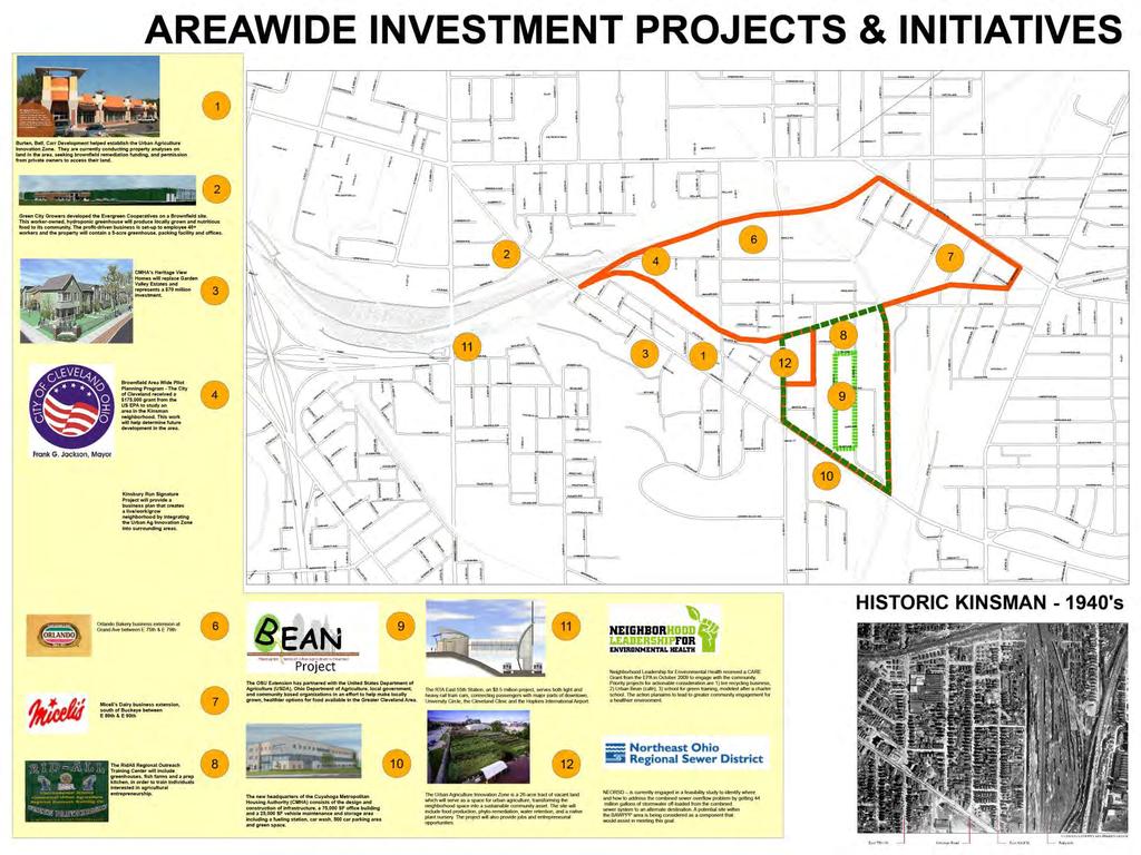
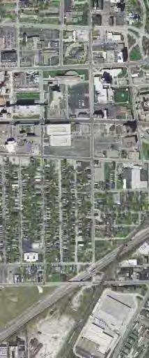
8 Map of Pilot Area
9 Project Partners Kinsman & Lower Buckeye Neighborhood Residents City of Cleveland: City Planning & Economic Development Opportunity Corridor Steering Committee / GCP City Architecture with Partners Environmental Burten, Bell, Carr Development, Inc. Buckeye Area Development Corporation CUDC, NPI & ParkWorks Environmental Health Watch Northeast Ohio Regional Sewer District Ohio State University Extension Program U.S. Environmental Protection Agency And the list is growing
10 What When Why Community Meeting - 1 BAWPPP Design Charrette #1 BAWPPP Design Charrette #2 BAWPPP Design Charrette #3 Community Meeting - 2 Advisory Committee Meeting - 2 Community Meeting - 3 Wednesday, July 20 th 6 8 pm Wednesday, August 3 rd 2 4 pm Wednesday, August 10 th 8 10 am Wednesday, August 10 th 6 8 pm Wednesday, September 21 st 6 8 pm Wednesday, October 19 th 2 3:30 pm Wednesday, November 16 th 6 8 pm To introduce BAWPPP grant to the community, receive feedback about areas of concern in the Kinsman & Lower Buckeye neighborhoods Facilitate a hands-on workshop soliciting the community s sustainable redevelopment ideas for brownfields in Development District 2 Facilitate a hands-on workshop soliciting the community s sustainable redevelopment ideas for brownfields in Development District 5 Facilitate a hands-on workshop soliciting the community s sustainable redevelopment ideas for brownfields in Development District 3 To present initial area-wide plan and receive community input and feedback To discuss outcome of Community Meeting #2 and refine ideas for Community Meeting #3 To present final area-wide plan, outline next steps for plan implementation and receive plan feedback Advisory Committee Meeting - 3 Wednesday, January 11 th 2 3:30 To discuss outcome of final area-wide plan and implementation
11


12 Allegro Realty Advisors Highest and Most Appropriate Use Model: Scope of Services: Phase I High-level Land Use Analysis Phase II Economic Impact Analysis
13 OC Project Overview Need Elements Improve system linkage Improve mobility Support planned economic development Goals and Objectives Public transportation Pedestrian and bike facilities


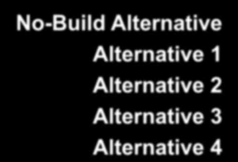
14 Steps 1-4 Steps 1-4 of ODOT PDP No-Build Alternative Alternative 1 Alternative 2 Alternative 3 Alternative 4


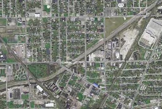
15 Step Study Area NORTH


16 Alternate A Alternate B Alternate C West Central East


17 Step 5 Context Sensitive Solutions Summary of CSS activities and feedback on priorities Roadway elements Roadside elements Community elements Vegetative elements Landform elements Corridor theme


18 Step 5 Context Sensitive Solutions Some elements will require additional funding sources Roadway Elements: Enhanced bridges Ornamental roadway lighting Ornamental railings and fencing Roadside Elements: Pedestrian amenities Ornamental pedestrian and access lighting Bike facilities


19 Step 5 Context Sensitive Solutions Community Elements: Plaza/Community areas Stormwater runoff sustainable management Some elements will require additional funding sources Vegetation Elements: Street trees Green/sustainable street program Planted roadway median


20 Step 5 Context Sensitive Solutions Landform Elements: Naturalistic approach to grading Some elements will require additional funding sources Corridor design character and Theme: Community Inspired Theme
21 Step 6 Alternatives and Recommendations
22 Step 6 Activities Revised Typical Section Community input Traffic Analysis Further developed alignments Evaluated alternates Established a Recommended Preferred Alternative

23 Step 5 Typical Section Local street 35 mph speed limit Sidewalk Multipurpose path Landscaping Lighting


24 Step 6 Typical Sections The number of lanes required may change once new traffic volumes are developed and analyzed


25 Typical Sections The number of lanes required may change once new traffic volumes are developed and analyzed


26 Alternate A WEST SECTION ALTERNATES At Grade Intersection Alternate B Grade Separated Alternate C Quadrant Roadway


27 West Section E.55 th Street to E.75 th Street At Grade Alternate A Alternate is not feasible due to geometric constraints at I-490/I-77 ramps
28 C West Section E.55 th Street to E.75 th Street Quadrant Alternate

29 Quadrant Roadway Example
 0 Commercial Business (Relocations) 4 (3) Public /Community/City Support Recommended as preferred alternative Preferred Yes Impacts listed are based on a 4-lane roadway.")
30 West Alternate Evaluation Alternate C Quadrant Roadway Potential Hazardous Material Sites Impacted 3 Historic/Parkland Impacts (Acres) 0 Residential Displacements (Units) 45 (71) to 48 (76) Church Displacements (Number) 0 Commercial Business (Relocations) 4 (3) Public /Community/City Support Recommended as preferred alternative Preferred Yes Impacts listed are based on a 4-lane roadway. The number of lanes required may change once the travel demand study is completed and new traffic volumes are developed and analyzed


31 CENTRAL SECTION ALTERNATES Alternate A Discontinuous Woodland Alternate B Continuous Woodland Alternate C Eastern Alignment
 A X X X X X X X X X X")
32 Central Section E.75 th Street to Quincy Avenue (Step 5) A X X X X X X X X X X X Ken Johnson Rec Center X X X X X X X X X
33 Central Section E.75 th Street to Quincy Avenue (Step 6) A X X X X X X X X X X Ken Johnson Rec Center X X X X X X X X X

 B X X X")

34 Central Section E.75 th Street to Quincy Avenue (Step 5) B X X X X X X X X Ken Johnson Rec Center
35 Central Section E.75 th Street to Quincy Avenue (Step 6) B X X X X X X X X Ken Johnson Rec Center
 0 0 Residential")
 12 (5) 16 (7) Public /Community/City Support Less Preferred Preferred Recommended as")

36 Central Alternates Evaluation Alternate A Discontinuous Woodland Alternate B Continuous Woodland Potential Hazardous Material Sites Impacted 7 12 Historic/Parkland Impacts (Acres) 0 0 Residential Displacements (Units) 6 (10) 11 (11) Church Displacements (Number) 1 1 Commercial Business (Relocations) 12 (5) 16 (7) Public /Community/City Support Less Preferred Preferred Recommended as preferred alternative No Yes Impacts listed are based on a 4-lane roadway. The number of lanes required may change once the travel demand study is completed and new traffic volumes are developed and analyzed


37 EAST SECTION ALTERNATES Alternate A Western Widening Alternate B Symmetric Widening Alternate C Eastern Widening RTA Street/Station Modifications
 0 Commercial Business (Relocations) 3 (3) Public /Community/City Support Recommended as preferred alternative Preferred Yes Impacts listed are based on a 4-lane roadway.")
38 East Alternate Evaluation Alternate C Eastern Widening Potential Hazardous Material Sites Impacted 3 Historic/Parkland Impacts (Acres) 1 (possible) Residential Displacements (Units) 4 (8) Church Displacements (Number) 0 Commercial Business (Relocations) 3 (3) Public /Community/City Support Recommended as preferred alternative Preferred Yes Impacts listed are based on a 4-lane roadway. The number of lanes required may change once the travel demand study is completed and new traffic volumes are developed and analyzed
39 Alternate A Alternate B Alternate C West Central East


40 Step 6 Recommended Preferred Alternative 87 8
41 Step 6 Recommended Preferred Alternative 87 8


42 Meetings #1 and #2 When: Tuesday, July 26, :00 pm to 4:00 pm and 6:00 pm to 8:00 pm Where: Calvary Hill Baptist Church 2171 E. 103 rd Street Next Steps Public Involvement Meeting #3 When: Wednesday, July 27, :00 pm to 8:00 pm Where: Elizabeth Baptist Church (former St. Hyacinth Church) 6114 Francis Avenue Meeting #4 When: Thursday, July 28, :00 pm to 8:00 pm Where: Mt. Sinai Baptist Church 7510 Woodland Avenue

43 Travel Demand Modeling Update Alternative Next Steps Environmental Process Draft Environmental Impact Statement Public Hearing Final Environmental Impact Statement Record of Decision

44 Project Schedule
45 Question & Answer
46 Thank You!