31 January 2019 VIA
|
|
|
- Frederick Miles
- 5 years ago
- Views:
Transcription
1 31 January 2019 VIA Michael Conklin Director of Environmental Affairs Town of Wilton Town Hall Annex 238 Danbury Road Wilton, Connecticut, RE: Review of the Aquarion Individual Diversion Permit Application to CT DEEP Cannondale Well Field Wilton, Connecticut Dear Mr. Conklin: In accordance with our 2 November 2018 proposal, Langan CT, Inc. (Langan), has prepared this letter documenting our review of the Aquarion Water Company s Individual Diversion Permit Application associated with the Cannondale Well Field prepared by WSP USA (WSP) in October Our review focused on permit application completeness, potential impacts to other users of groundwater in the vicinity of the Cannondale Well Field, and potential impacts to the environment, including the Norwalk River and associated wetlands, in the vicinity of the well field. We have reviewed the Permit Application in its entirety and provided below are comments and recommendations for your consideration. For ease of review and discussion, we have provided our comments and recommendations in a numerical format. The order of the comments and recommendation has no bearing on emphasis or relative significance. I. Application Completeness Langan believes that the Permit Application is deficient in certain respects, several of which are key to a proper assessment of potential impacts to other users of groundwater and to the environment. Although listed under the heading of Application Completeness several of our comments and recommendations are relevant to the other topic headings as well. 1. The Permit Application lacks a hydrologic budget for the watershed which is a fundamental and essential tool to assess both the impacts and long-term sustainability of the proposed withdrawal. Langan recommends that Aquarian include a water balance with the Permit Application to account for the average inflows and outflow of water within the watershed from which PW-1 will draw water in order to justify that the diversion is safe and viable in the long term. The water balance should, at a minimum, account for average precipitation and associated aquifer recharge (inflows) versus evapotranspiration, direct runoff, and other users of water as applicable (outflows). Without a water balance it is not possible to determine the long-range effect of the proposed diversion on water resource management or the environment.
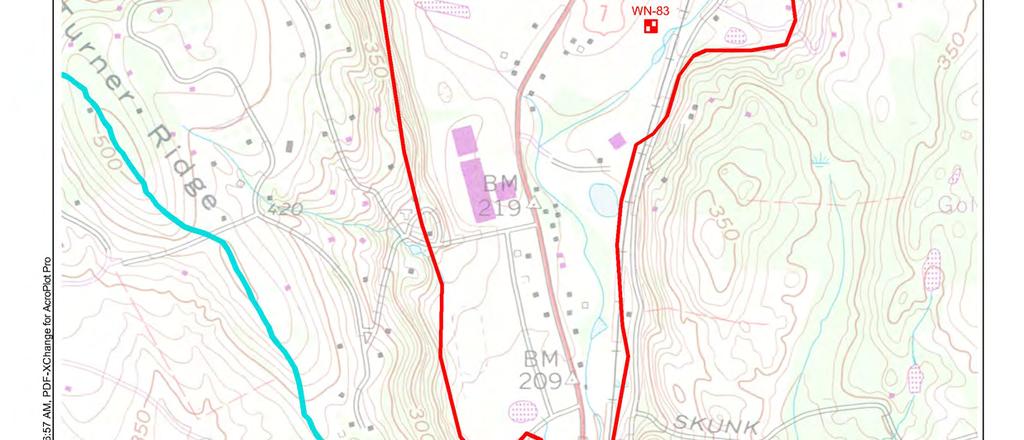
2 Review of the Aquarion Individual Diversion Permit Application to CT DEEP 31 January 2019 Cannondale Well Field Wilton, Connecticut Page 2 Langan Project No Langan recommends that Aquarion provide a detailed explanation as to how the concept presented in the Mitigation Plan (Attachment L to the Permit Application) with regard to pumping PW-1 at no greater than 10 percent of the seven day average Norwalk River flow will be implemented with real-time data collection via telemetry. As presented, the concept lacks the detail required to accurately assess the effect of the proposed diversion on the Norwalk River, including riverine habitats and water quality. 3. Langan believes that a copy of the well as-built construction detail and boring log associated with PW-1 (PW-1 is also referred to on drawings submitted with the Permit Application as WN-83 ) should be made a part of the Permit Application. 4. Throughout the Permit Application, figures depicting PW-1 or WN-83 refer to the approximate location of the production well. An accurate well location plan, prepared by a Connecticut Licensed Surveyor or Engineer, should be made a part of the Permit Application. 5. In Attachment D to the Permit Application, under Item 7 (Withdrawal and Use of Water), the following items either require completion or are unclear and warrant modification: a. maximum rate of withdrawal This section was left unanswered. A maximum withdrawal is to be provided on a gallons per minute (gpm) and cubic feet per second (cfs) basis. b. frequency of withdrawals This section denotes 24 hours per day and 365 days per year which is inconsistent with the Mitigation Plan that cites that no pumping will occur from March through June, annually, and that pumping will either be limited or reduced during periods of low flow based on the 7- day average flow of the Norwalk River. II. Potential Impacts to the Environment 6. In order to preclude, or at least minimize, potential harmful impacts to the Norwalk River, and associated wetlands and fauna, Langan recommends that Aquarion agree not to pump under low flow conditions (i.e., include a passing flow requirement in any permit). The applicant has derived a Q 7,101 value for the Norwalk River near the production well at 0.63 cfs. The applicant also states that up to 0.5 cfs will be derived from the Norwalk River via induced flow when pumping 1-million gallons per day. Therefore, if the applicant does not pump from PW-1 while flows at the Norwalk River adjacent to the well are less that 1.13 cfs (O.63 cfs cfs), there will be no impact to the river from pumping during low flow conditions that are outside the realm of natural river fluctuations. 7. The ecological baseline evaluation in the Permit Application focuses on nearby resources, but does not catalog wetlands and other natural resources in the defined well area of influence (AOI), as depicted on Figure 6 in Attachment K-1 to the Permit Application. While potential impacts will first be observed in the most proximal wetlands and surface waters to PW-1, the applicant should not assume that the nature of those impacts automatically mean there will be 1 The Q 7,10 is a commonly used low flow statistic, that is the average minimum stream flow that can be expected for seven (7) consecutive days once every ten (10) years. { DOCX Ver. 1}
3 Review of the Aquarion Individual Diversion Permit Application to CT DEEP 31 January 2019 Cannondale Well Field Wilton, Connecticut Page 3 Langan Project No no, or lesser, impacts to more distant resources. Other natural resources (e.g., wetlands and ponds) within the AOI have the potential to be impacted and should therefore be evaluated. 8. The Mitigation Plan makes no mention of the YMCA pond. Given the observed groundwater level decrease in the well near this pond from the 90 day test, we recommend adding the measurement of the water elevation in the pond as part of the monitoring steps set forth in the Mitigation Plan. 9. The Mitigation Plan does not specifically propose the production of a formal written report. Langan recommends that the Mitigation Plan be modified to require the preparation of a written annual report to CT DEEP, with a copy to the town and other stakeholders, at the end of every calendar year, at least for the initial five years of operating PW-1. The report should include all relevant data previously collected and an analysis of the data with regard to potential impacts on nearby wetlands and surface waters as well as on private wells in the AOI. The seasonality of the imposed pumping limitations should be evaluated to determine if they are acceptable or should be modified. Year-to-year variations in weather and ecological system responses should also be discussed. The annual report should set forth any additional mitigation recommendations based on this analysis. 10. Based upon comments 8 and 9, in particular, Langan recommends Aquarion revise and update the proposed Mitigation Plan to include: a. Monitoring of the YMCA pond level on a monthly basis for three years. b. Submission of an annual written report at the end of each calendar year to provide the data collected during the year (and previous years) and an evaluation (based on the data collected and observed environmental conditions of the wetlands, vernal pools and surface waters) of whether any additional seasonal modifications are needed to the rate of pumping or the period of well operation, and what, if any, additional mitigation ought to be implemented the following year. c. The vernal pool water level monitoring should be performed every month for the first three years to gather seasonality data and potential groundwater withdrawal impacts. d. Baseline surface waters outside of the AOI should be identified and monitored to provide a baseline to compare the wetlands and surface waters near the well against other regional features. III. Potential Impacts to Other Users 11. All shallow wells within the pumping zone of influence should be enumerated and possible adverse impacts from PW-1 should be evaluated as part of the Permit Application. Potential mitigation efforts or options should be discussed with the respective property owners to gain their consent prior to pumping. { DOCX Ver. 1}

 Stephen Studer (Berchem Moses PC) Ira Bloom (Berchem Moses PC) \\langan.")
4 Review of the Aquarion Individual Diversion Permit Application to CT DEEP 31 January 2019 Cannondale Well Field Wilton, Connecticut Page 4 Langan Project No We are available to meet with you to review our comments and recommendations. If you have any questions or concerns, please do not hesitate to call or me. Sincerely, Langan CT, Inc. Brian A. Blum Senior Associate BAB:DC:hc David Charette Principal Cc: Lynne Vanderslice (First Selectwoman) Stephen Studer (Berchem Moses PC) Ira Bloom (Berchem Moses PC) \\langan.com\data\par\data1\ \project Data\Correspondence\Cannondale Well Field Diversion Permit Application Review docx { DOCX Ver. 1}
5 Received 2/11/2019 To: Cannondale Well Stakeholders The following are responses to questions identified during the November 7, 2018 informational meeting regarding Aquarion s Cannondale Well Diversion Permit application and distributed on November 30th. 1. Would Aquarion consider a low flow threshold in the Norwalk River below which the mitigation plan would prohibit pumping? Aquarion will modify its proposed Mitigation Plan to include a prohibition on pumping from the Cannondale Well when flow in the Norwalk River is less than 10 percent above the theoretical 7Q10 flow at the to-be installed gage upstream of the wellfield. This prohibition is intended to prevent flow at this location from dropping below the 7Q10. The 7Q10 flow is 0.63 cfs as determined through a correlation with flow (1963 through 2017) measured at gage location No , thus, withdrawals from the Cannondale Well will be discontinued when flow at the proposed upstream gage is equal to or less than 0.69 cfs. 2. Can the need for activating the Cannondale Well be avoided with water conservation? Although conservation is a key component of Aquarion s water supply planning for the region, it will not offset the benefits of activating the Cannondale Well. As described at the informational meeting, the primary driver for activation of the Cannondale Well is to improve system reliability and resiliency by providing a source of supply closer to the point of consumption. Reducing customers usage of water through conservation will help reduce withdrawals from all of Aquarion s sources, but will not eliminate the need for this new source. 3. Please prepare a water budget for the watershed. See discussion presented in Attachment I. 4. Were river water quality data, particularly temperature, collected during the testing and considered in the ecological evaluations? During the 2013 test, groundwater was sampled from the well and analyzed for VOCs, inorganics and bacteria. The results were included in the diversion permit application and are included in Attachment II of this response. The well will need to be resampled for the CTDPH-routine analysis prior to being put into service because it has been over 5 years since last tested. Typically, groundwater must be sampled every 1 3 years, depending on the analysis. In addition to the groundwater sample, groundwater and the Norwalk River were sampled periodically during the 1984 and 2013 tests test and the data are presented on tables 4 and 7 in the diversion application (also included in Attachment II). On July 11, 2013 groundwater and surface-water samples were collected after approximately 27 hours of continuous pumping of PW1 and analyzed for the parameters specified in Table 1 of Section 5.(b)(F)i. of the Water Treatment Wastewater General Permit. The samples were collected from a tap on the well and from the Norwalk River near the test discharge point. The groundwater sample results were well below the WTW General Permit maximum concentrations for effluent being discharged towards a river. The lower suspended and dissolved solids present in the surface water sample were not indicative of discharge creating turbid conditions. This is further Aquarion Water Company 600 Lindley Street Bridgeport, CT aquarionwater.com
6 supported by the turbidity in the surface-water sample which was 2.90 NTU (although not applicable, the Federal Secondary Drinking Water Standard is 5 NTU). The parameters that were tested in groundwater were within drinking water standards, although sodium was present at a concentration of 34.4 mg/l (milligrams per liter), slightly above the CT DPH notification concentration level of 28 mg/l for people on restricted diets. In addition, chloroform was detected at a concentration of 3.1µg/l (micrograms per liter), below the Federal Drinking Water Standard of 5µg/l. There were no other detections of VOCs above the laboratory minimum reporting limits in the groundwater. The detection of chloroform is attributed to the disinfection procedures (using dilute bleach solution) that were employed prior to sample collection. In addition to groundwater quality, temperature of the groundwater from PW1 and temperature of the Norwalk River upstream of the discharge were monitored during the 1984 and 2013 tests. The temperature readings were periodic throughout the 1984 test and are shown graphically (included in Attachment II). Based on the sporadic readings, the water temperature before the test was 50oF (May 7, 1984) and fluctuated between 50 o and 56 o F during the test. The river temperature before the test was 60 o F and fluctuated between 68 o and 74 o F during the test. The fluctuation in river temperature was reflective of the seasonal change. Based on the periodic temperature measurements, there is no apparent correlation between the fluctuating temperatures in the river and those measured in the well during the test. During the 2013 test, groundwater and surface water temperatures were monitored. As seen by the figure (included in Attachment II), the groundwater temperature was initially 11.6 o C before the start of the test, decreased down to 11.2 o C as water from the surrounding aquifer was drawn at the start and during the test and then increased to 11.8 o C at the end of the test. The surface water temperature was initially 23.5 o C and increased slightly to 24.4 o C at the end of the 6-day test. Based on the duration of the test, it is not discernible if the small variation in groundwater temperature was a result of surface-water influences. 5. The Mitigation Plan is designed to minimize the impact on the Norwalk River from the proposed diversion. Is it possible to develop a Plan that can improve the River ecologically, not just minimize the impact on it? In addition to minimizing impact from the proposed diversion on the Norwalk River Aquarion has explored, and is committed to working in consultation with, DEEP Fisheries and Trout Unlimited to support ongoing efforts to enhance the river s habitat. 6. Under the DEEP Streamflow Standards and Regulations the reach of the Norwalk River adjacent to the Cannondale Well is a natural Class 2 but it is a proposed Class 3 stream because of the presence of the Well. Should the required flow meet Class 2 standards? DEEP s Streamflow Standards and Regulations require minimum releases from reservoirs based on the classification of streams below dams, and do not apply to groundwater withdrawals or other activities impacting streamflow. Presumably in anticipation of the potential future application of the stream classifications on other activities, the regulations require that all streams in the State be classified, and that the classification consider numerous in-stream and out-of-stream factors, including the proximity of previously identified potential future public water supply sources like the Cannondale Well. It would be inappropriate to apply the classifications developed under the Streamflow Standards and Regulations to activities other than dam releases. It would also be inappropriate to ignore just one of the many balancing factors that the regulations require be considered in the classification process. Aquarion Water Company 600 Lindley Street Bridgeport, CT aquarionwater.com
7 In addition, the Class 2 standard defined in the Streamflow Standards and Regulations is a stream segment that exhibits the depth, volume, velocity and variation of stream flow and water levels necessary to support and maintain habitat conditions supportive of an aquatic, biological community minimally altered from that typically present in a free-flowing river or stream system of similar size and geomorphic characteristics under the prevailing climatic conditions. It is unclear whether or not the proposed Cannondale Well and Mitigation Plan impacts the Norwalk River s ability to meet this standard, or if and how the Mitigation Plan would need to be modified to meet the standard. 7. Do the aquifer data from the 1983 and 2013 tests reflect current conditions adequately to be used in this application? Specifically, how did rainfall during the 2013 tests and watershed changes since the 1984 tests influence the results? The hydrogeology of the Cannondale aquifer system has remained relatively unchanged (except the construction of the mitigation wetland) with respect to aquifer parameters and boundary conditions (surface-water bodies and physical aquifer extent) since the initial assessment completed in the early 1980 s. This can clearly be seen in the similarity in the aquifer s drawdown responses after 6-days of pumping between the 1984 and 2013 aquifer tests. The table below shows the change in drawdown between 3 and 6 days of pumping during the 1984 and 2013 aquifer tests. The observed differences in drawdown between the two tests are attributed to the difference in withdrawal rate. The 1984 withdrawal rate was 1.5 mgd and the 2013 withdrawal rate was mgd. Measured Drawdown after 3-days of pumping (feet) Measured Drawdown after 6-days of pumping (feet) Change in Drawdown between 3-days and 6- days of pumping Well ID (at 1.5 mgd) (at 1.3 mgd) (at 1.5 mgd) (at 1.3 mgd) (at 1.5 mgd) (at 1.3 mgd) PW (WN 86) (WN 90) mgd million gallons per day This similarity in drawdown response between the 1984 and 2013 tests is typical of aquifer systems that have not undergone any major structural changes to saturated-thickness and recharge sources and supports the conclusion that additional aquifer testing of the system is not required, especially taking into consideration the proposed water-level monitoring requirements presented in the proposed mitigation plan. Furthermore, a review of aerial photographs and tax cards in the Cannondale aquifer indicates that development in this area has been limited. Thus, changes to surficial materials overlying the aquifer have not changed significantly over time. The residential development located on Cobblestone Place (northeast of the well field) was built prior to the 1984 test (developed in 1970). Based on available records, these homes are served by individual bedrock wells. There has been no significant increase in housing density throughout the Cannondale aquifer since the 1984 test. After the 1984 test, a nursing home (Wilton Meadows) was constructed in 1987 at 439 Danbury Road. The nursing home was expanded to include a second facility and house in 1998 and 2009, respectively (435 Danbury Road). The facilities are concentrated northwest of the wellfield, located at the intersection of Danbury Road and Olmstead Hill Road. The Route 7 corridor has remained consistent in land use and development since the 1984 test, with the exception of the Route 7 expansion that Aquarion Water Company 600 Lindley Street Bridgeport, CT aquarionwater.com
8 occurred circa Based on this review, there have been no significant changes in development impacting surficial deposits, with the exception of the nursing home, providing additional evidence that the data from both aquifer tests remains relevant. With respect to the concern that the tests were conducted during unusually wet seasons the tests that were conducted were performed to observe potential impact to the underlying aquifer. CTDEEP guidance for a single well aquifer test specifies that there should be no rain event exceeding ½ inch of rain in any 24-hour period or 1 inch of rain during any 72-hour period within five days prior to the test and these same conditions apply during 72 hours of testing. Precipitation was monitored during the 2013 testing period using a manual rain gauge that was set up in the well field one week prior to the aquifer test. The total precipitation recorded during the background period (July 3 July 9) was 0.08 inch, satisfying the CT DEEP pre-test guidance. During the 6-day pumping period, a total of 0.83 inches of rain accumulated in the rain gauge. A more important reflection of the relative wet or dry conditions during the aquifer test is the Norwalk River s flow-duration during the pumping phase of the aquifer test. The average stream flow at the USGS s South Wilton gaging station during the pumping phase of the 2013 aquifer test (July 10 through July 16) was 26.2 cfs and the average stream flow during the final 24-hours of the test was 19.2 cfs. These flows correspond to the Norwalk River flows that are equal to or exceed 59- and 67-percent of the time (Attachment III). Thus, the 2013 aquifer test was not conducted during a unusually wet period. The average flow at the USGS South Wilton Norwalk River gage during the pumping phase of the 1984 aquifer test (June 19 September 17) was 51.7 cfs which is below the long-term average of 57.3 cfs (1962 March 2018). In addition, the average Norwalk River flow the last 30 days of the aquifer test was 11.9 cfs that corresponds to the Norwalk River flow that is equal to or exceed 79-percent of the time. It is acknowledged that the initial half of the testing was completed during a wet period, however the last third (30) days of the test were completed during a dry period. 8. Was enough time spent in the field for the ecological evaluations? Field surveys of wetlands and the Norwalk River were conducted starting in 2011 and continuing into These field surveys include: Field characterizations and habitat assessments of the Norwalk River from the Dam above Cannon Road south past the Wilton YMCA driveway bridge. Two river cross sections were surveyed and wetted perimeter analysis was performed to evaluate potential aquatic habitat impacts. Evaluation of wetland habitats south of the wellfield including the floodplain forest and DOT Mitigation Wetland. Vernal pool breeding surveys conducted during the spring amphibian breeding seasons in 2017 and Two vegetation transects were established in the floodplain wetland and the DOT Mitigation Wetland. Vegetation cover and species were recorded in 2018 to serve as baseline data. We believe that these field studies and the proposed mitigation/monitoring plan are appropriate for the ecological evaluations. Aquarion Water Company 600 Lindley Street Bridgeport, CT aquarionwater.com
9 9. Should the Wildlife Management Area be given additional protection? The Norwalk River in the vicinity of the well field is a Class 3 Wild Trout Management Area. We are not aware of any other Wildlife Management Areas in the vicinity of the well. The Mitigation Plan included in the Diversion Permit application contains measures to maintain year-round trout habitat. 10. Provide more information on the impact on private wells and plans for mitigation should any unanticipated problems occur. As part of the diversion permit application process, available well log records at the Wilton Health Department and the Connecticut Department of Consumer Protection website were reviewed for properties located within 1,000 feet of the Cannondale Well. Thirty properties were identified with private potable supplies. All of the well records that were available for review, with the exception of one property, indicate that the wells are completed in bedrock. Although these wells were not monitored during the 1984 or 2013 aquifer tests, no discernible adverse pumping-related impacts are anticipated for any of the identified bedrock wells. It has been WPS s experience that there is little, if any, pumping-related impact to nearby bedrock wells in similar hydrogeologic settings. The only available well record for a well completed in the overburden was for the Town of Wilton property located at 415 Danbury Road. During the day test, two wells completed in the overburden were identified and included in the monitoring program. These included wells at one home located at 415 Danbury Road (approximately 1,140 ft west of PW-1) and the Hansen well (currently the Talbot House well) located at 426 Danbury Road (approximately 530 ft east of PW-1). During the 90-day test, the 426 Danbury Road well had a static water level of 2.30 ft bg (feet below grade) and at the end of the test drew down feet to ft bg (approximately 2 feet of the feet of drawdown is attributed to seasonal regional decline in water levels). The shallow dug well at 415 Danbury Road had a static of 5.75 ft bg and at the end of the test the water drew down 5.25 feet to ft bg (approximately 2 feet of the 5.25 feet of drawdown is attributed to seasonal regional decline in water levels). By the end of the test the 415 Danbury Road well went dry because the bottom of the shallow dug well is 11 ft bg. A review of historic documents indicate that the 415 Danbury Road shallow dug well was first monitored during preliminary testing in Because it was evident that there was water level interference at this well during the preliminary test, Aquarion (formerly Bridgeport Hydraulic Company) drilled a deeper well at this property to serve the house (invoice included in Attachment IV). This well, drilled in March 1984 is completed in the overburden aquifer to a depth of 152 ft bg (see Attachment IV). Although the well was installed prior to the 90-day test, only the shallow dug well (11 feet deep) was monitored during the 1984 test. Because the house is served by a deeper overburden well (reported yield of 13.5 gpm) with approximately 145 feet of available water and the shallow well had a drawdown of approximately 5 feet after 90 days of continuous pumping, this home is not anticipated to be adversely affected by the operation of the Cannondale Well. The 426 Danbury Road Hansen well was a shallow hand-dug well approximately 22 ft bg. The property was sold to Talbot House LLC in A review of the available well records did not indicate if this well was ever deepened or replaced. A discussion with the current property owner indicates that this well is still in use and was never replaced or deepened since it was purchased in As discussed above, after 90 days of pumping the Cannondale (at 1.5 mgd), the water level in the Hansen well had lowered approximately 12 feet, 8 feet from the bottom of the well. Based on the Aquarion Water Company 600 Lindley Street Bridgeport, CT aquarionwater.com
10 documented water-level interference in this well, we recommend monitoring water levels in this shallow dug well if the diversion is approved. In addition, a recent review of files associated with the 1984 test indicate that there were complaints from two private homeowners that were not included in the offsite monitoring program; one from 408 Olmstead Hill Road and one from 411 Olmstead Hill Road. The bedrock well at 408 Olmstead had complaints of pump problems that were not related to the 90-day pumping test. This home is currently served by Aquarion water. The homeowner at 411 Olmstead Hill Road issued complaints to Aquarion towards the end of the pumping test period. Upon further inspection, it was determined that the well was a 21-foot hand dug well (intake screen set at 16 ft bg) and was experiencing pump problems. After the homeowner lowered the intake screen to 19 ft bg, there were no further pump problems at this well during the test. A 1985 well log (included in Attachment IV) indicates that a bedrock well was installed on the property in This well is completed in bedrock with a total depth of 605 feet. Because the home is now served by a bedrock supply well and not a shallow dug well, this home is not anticipated to be adversely affected by the operation of the Cannondale Well. Potential Impacted Private Potable Supply Well Summary Table Address Shallow Replacement Overburden Well Depth Well Depth Comments 415 Danbury Rd Bedrock well drilled in 1984 but not monitored during 90-day test. Not expected to be impacted by the Cannondale Well. 426 Danbury Rd. 22 NA Well currently in use. Property owner considering connection to Aquarion system. 408 Olmstead Hill Rd. 200 Bedrock well. Pump problem not related to aquifer test; residence is currently served by Aquarion system. 411 Olmstead Hill Rd Bedrock well drilled in 1985 not expected to be impacted by the Cannondale Well. Potential mitigation of any confirmed interference with a private shallow overburden well and the well field could include: a. Deepening the well. b. Lowering the well pump. c. Connecting the residence to the public water system. 11. What happens to the monitoring and mitigation plan after the initial 5-year review period. As stated in the Mitigation Plan (Attachment L of the diversion permit application) this plan is intended for the first five years after issuance of the permit. Following the five-year monitoring period the data would be re-evaluated and, if necessary, the monitoring program would be modified by the project team and the CT DEEP. It is anticipated that the DEEP will conditionally require continued monitoring of the sensitive receptors after reviewing the monitoring data collected during the first five years of operation. The details of the monitoring requirements will be developed after review of the data. Aquarion Water Company 600 Lindley Street Bridgeport, CT aquarionwater.com
11 12. Is the application strictly for Well 1 in the Cannondale Wellfield? The WUCC planning documents indicate that activation of additional wells may be necessary. This application is strictly for Well 1 in the Cannondale Wellfield. The WUCC planning documents indicate that Aquarion may need to activate the Housatonic Wellfield in Shelton to provide an adequate margin-of-safety between projected supply and demand in the Greater Bridgeport System. Reactivation of the Housatonic Wellfield is also a condition of DEEP s approval in two Aquarion diversion permits. Future reactivation of the Housatonic Wellfield does not impact this application or the need for the Cannondale Well. 13. Has Level A or Level B mapping been completed for the Cannondale Wellfield? A preliminary Aquifer Protection map has been prepared in response to this comment. See Attachment V for a full discussion. 14. What has been happening in the Norwalk River Watershed? The stream reportedly doesn t flow as well as it used to. Based on the annual average daily stream flow and 7-day average annual low flow measured during the period of record (1962 to 2018) at the USGS South Wilton # stream gage station, there is no apparent long-term declining trend in Norwalk River stream flows (Attachment VI). In addition, a review of land use data presented on the University of Connecticut s Center for Land Use Education & Research webpage ( shows only marginal changes in land use upgradient of the USGS South Wilton Gage from 2006 through 2015 (last year published). A summary of the land use conditions in 2006, 2010 and 2015 are shown in the table below. The 2013 pumping test would be reflective of the land use conditions between this time period. WSP is unaware of and have found no record of any newly DEEP-permitted sources of withdrawal from the basin since the 2013 pumping test. Change in Land Use Summary ( ) Land Use Type 2006 (square miles) 2010 (square miles) 2015 (square miles) Developed Turf & Grass Other Grasses Agricultural Field Deciduous Forest Coniferous Forest Water Non-forested Wetland Forested Wetland Tidal Wetland Barren Land Aquarion Water Company 600 Lindley Street Bridgeport, CT aquarionwater.com
12 Land Use Type (square miles) (square miles) (square miles) Utility Corridor TOTAL Aquarion presents the application as not for growth with the explanation that water from the Cannondale Well cannot be identified as available water because it is not available year round. Does Aquarion mean safe yield or available water? Is the available water based on annual availability? As defined in the Water Supply Plan Regulations (RCSA 25-32d) margin-of-safety is the unitless ratio of available water to demand. Margin-of-Safety is evaluated under three conditions: annual average available water/demands, maximum monthly available water/demands and maximum daily available water/demands. Available water is the maximum amount of water a company can dependably supply, taking into account safe yield, permit limits, and hydraulic and treatment constraints. The safe yield of the Cannondale Well is estimated to be greater than 1 mgd, however available water from the well will be limited by its diversion permit and the associated mitigation plan. As presented at the November informational meeting (Slide 24), based on the proposed mitigation plan, estimates of historical Norwalk River flow at Cannondale, and an assumed 30% depletion ratio, it is estimated that Aquarion could have withdrawn an annual average amount from the Cannondale Well between 2009 and 2017 that ranged between approximately 0.45 and 0.65 mgd. The average annual amount that the Cannondale Well can dependably supply for available water has not yet been determined, but is likely less than 0.45 mgd. The available water that the well can supply on a given day is zero based on the streamflow and shutoff provisions in the mitigation plan. Similarly, the available water that can be dependably supplied to meet customer demands during a maximum month is also likely to be zero. Because the Cannondale Well will not be able to provide available water to meet maximum day or maximum month demands, and because its available water to meet annual average demands is difficult to reliably quantify and small compared to the system s existing available water (72 mgd), the well does not provide benefit for serving new customers. 16. Aquarion deducts releases required under the Streamflow Regulations from the water available to it. Should this deduction be postponed or qualified since the actual flow standards will not be met for 10 to 20 years and there are many off-ramps? The available water utilized to determine the margin-of-safety for Aquarion s Greater Bridgeport System is based on the reservoir releases currently required by regulation (RCSA a). In its next Water Supply Plan update, the impact of reservoir releases required by the new Streamflow Standards and Regulations (RCSA b) on available water will be considered in the timeframe that the releases are expected to begin. This projected available water will be compared to projected demands at the same timeframe to determine projected margin-of-safety. Aquarion Water Company 600 Lindley Street Bridgeport, CT aquarionwater.com
13 17. Is it definite that Comstock Dam will be raised? What will this do to the water budget? Comstock Brook is a tributary of the Norwalk River downstream of the Cannondale Well. Aquarion does not own or operate the Comstock Dam, nor have any knowledge of plans to raise it. If the Comstock Dam were to be raised it would require an extensive permitting process, including a Diversion Permit. 18. How will the 30% depletion ratio used to estimate the impact of withdrawals on flow in the Norwalk River be verified? As stated in the Mitigation Plan, stream depletion will be reevaluated by installing piezometers in the river near the well field, conducting in-situ stream bed permeability testing, monitoring temperature in the well and the river, installing a continuous recording stream gage upstream of the well field, installing two staff gages downstream of the well field (preferably by the USGS) and reviewing data from the existing USGS South Wilton stream gage. As part of the evaluation Norwalk River flow at the downstream staff gages will be measured at least twice per year. The gaging events would be conducted during a prolonged period of continuous pumping (at least 5 days) and followed by, or starting with, an extended recovery period (lasting a minimum of 3 days). These downstream measurements would take place under the following conditions: Upstream gage flow is less than 16 cfs. o The requested withdrawal from the Cannondale well field is 1.55 cfs, which is approximately 10% of the targeted flow (16 cfs) listed above. It has been WSP s experience that a staff gage is accurate to within plus or minus 5-percent of the measured flow. Therefore, the error associated with upstream and downstream gaging is 10-percent, so to measure the induced infiltration (stream depletion) from the stream or river, the well field withdrawal rate should be greater than 10-percent of the flow measured at the upstream gaging location. Precipitation meets the criteria outlined in CTDPH Title 25 Water Resources, Flood and Erosion Control 25-32d-4(b)(3)(F)(i) o Maximum precipitation of 0.50 inches allowed within a 24-hour period and one inch in any 72-hour period. The collected stream gage data would be used with piezometer data, streambed permeability data and with groundwater and surface-water temperature information to verify and/or adjust the stream depletion ratio used to determine compliance with the withdrawal limits in the Mitigation Plan. The results from this analysis would be submitted to DEEP in an annual report for review. 19. What other diversions exist in the Norwalk River Basin? The table below summarizes the registered and permitted diversions within the Norwalk River Basin (7300). Note that all registration of water diversions occurred in 1982 and 1983 (diverters had until July 1, 1983 to submit registration data, however, new diversions that were installed after July 1, 1982 were subject to the permitting requirements). Therefore, any registrations listed on the table below would have existed before the day pumping test. Aquarion Water Company 600 Lindley Street Bridgeport, CT aquarionwater.com
14 The permitted diversions in the basin are a combined total of mgd (or 291,000 gallons per day). The Laurelwood well field in Ridgefield is located upgradient of the Cannondale well field and would not be impacted by the operations of the Cannondale well. The Rolling Hills Country Club is located cross-gradient of the Cannondale well field and all of the permitted wells are completed in bedrock and would not be impacted by the operations of the Cannondale well completed in the overburden. Any diversion (registration or permit) listed for 0.0 mgd and any listed interconnections are not included on the table. Note that the registrations listed in Norwalk are located downstream of the proposed Cannondale Well Field and would likely not be impacted by the operations of the Cannondale well. Registrant Name Name of Diversion Registered /Permitted Withdrawal (mgd) Town Registered Diversion Norwalk First Tax District Water Department Norwalk First Tax District Water Department Norwalk First Tax District Water Department Norwalk First Tax District Water Department Norwalk Second Tax District Water Department Deering Well No Norwalk Deering Well No Norwalk Layne Well No. 1R 1.90 Norwalk Layne Well No Norwalk Fairfield Ave Well 1.01 Norwalk Perkin-Elmer Corp PE-G&B Well 1 (irrigation) Perkin-Elmer Corp PE-G&B Well 2 (irrigation) Perkin-Elmer Corp PE-G&B Well 3 (irrigation) 0.07 Redding 0.07 Redding 0.07 Redding Perkin-Elmer Corp Rolling Hills Country Club Aquarion Water Company of Connecticut mgd million gallons per day PE Raynor Well (irrigation) Permitted Diversion 0.04 Redding Pond E and Wells Wilton Aquarion Laurelwood Wellfield Wells Nos. 1 and Ridgefield Aquarion Water Company 600 Lindley Street Bridgeport, CT aquarionwater.com

15 20. Can we determine the amount of impervious coverage that would need to be removed from the watershed to compensate for the requested withdrawals? Not at this time. 21. Would Aquarion consider adding a stream gauge to the Norwalk River now to start collecting flow data? Not at this time. Once a permit has been issued, Aquarion will initiate stream gaging in advance of use of the Cannondale Well. H:\Aquarion\Cannondale\2019\Cannondale Well Informational Meeting Responses final.docx Aquarion Water Company 600 Lindley Street Bridgeport, CT aquarionwater.com
16 ATTACHMENT I WSP USA
17 MEMORANDUM TO: FROM: Carolyn C. Giampe Aquarion Water Company Kenneth Taylor, CPG Karen Destefanis, CPG DATE: December 7, 2018 SUBJECT: Cannondale Aquifer Water Balance During the November 7, 2018 stakeholders meeting, Mr. Brian Blum of Langan Engineering, hired by the Town of Wilton to aid in their review of the proposed Cannondale well field s individual diversion permit application, inquired about the Cannondale Aquifer s water budget. In response to this inquiry, WSP (formerly Leggette, Brashears & Graham, Inc. (LBG)) has provided a summary of the groundwater model flow budget (Appendix I) derived from the groundwater flow model that was developed to provide technical support for the diversion permit application. The model flow budget shows the simulated total recharge to the Cannondale Aquifer under average recharge conditions (1.678 mgd (million gallons per day)) with no pumping, under a 180-day no areal recharge drought simulation with the request withdrawal rate of 1.0 mgd (1.425 mgd), and under 180-day no areal recharge drought simulation with no withdrawal (1.006 mgd). These results indicate that sufficient recharge is available to sustain the requested maximum withdrawal rate of 1.0 mgd. A detailed description of the model s initial structure is presented in the Hydrogeologic Report submitted in Individual Diversion Permit Application for Aquarion Water Company, Cannondale Well Field (WSP USA, 2018). In addition to providing a summary of the groundwater model s groundwater flow budget, WSP has also provided the following yield potential of the Cannondale Aquifer. CANNONDALE AREA AQUIFER YIELD POTENTIAL An evaluation of the yield potential of the Cannondale Area Aquifer (CAA) is provided below. The CAA is located within the Norwalk River Sub-Regional Drainage Basin in the Western Highlands section of the New England physiographic province (Rodgers, 1985). The aquifer consists mostly of unconsolidated stratified drift originating from late Pleistocene lacustrine deposits, overlain by recent alluvial layers along the banks of the Norwalk River. The CAA covers an area roughly 3.25 miles in longitudinal distance, spanning over 3,000 feet in the widest areas. Figure 1 shows the areal extent of the CAA. The extent of the CAA for this assessment was delineated based on the published stratifieddrift/till contact, which was obtained from the Connecticut Water Resources Bulletin No. 17 for Southwestern Coastal River Basins (Ryder et al., 1970). The Norwalk River is a major drainage basin and is a regional groundwater discharge point. WSP USA Formerly Leggette, Brashears & Graham, Inc. 4 Research Drive, Suite 204 Shelton, CT, Tel.: +1 (203) wsp.com
18 As part of the evaluation, a sustainable yield value (under normal and drought conditions) was estimated for the aquifer. The sustainable yield value is the rate at which groundwater can be withdrawn from the aquifer over a period of time without significant changes in groundwater storage. As a conservative estimate, sustainable yield is equal to annual aquifer recharge. In this assessment, the sustainable yield was assumed to have three components: direct infiltration from precipitation on the aquifer, recharge from upland till areas, and induced infiltration from rivers/streams. Groundwater Recharge Sources Published mapping data (Ryder et al., 1970), data from two aquifer tests (90-day test and a 6-day test conducted in 1984 and 2013, respectively) and available well log records indicate that the CAA is an unconfined aquifer and that the Norwalk River is hydraulically connected to the aquifer. Therefore, the aquifer has three primary sources of recharge: precipitation that falls directly on the surface of the stratified drift; groundwater flow from surrounding hills; and infiltration from surface-water bodies when pumping of a well depresses the level of the groundwater table below the water level of the stream. Direct Recharge to the Stratified Drift Deposits The annual volume of recharge from precipitation to the surficial aquifer depends upon two factors: the extent of the coarse-grained materials and the annual precipitation rate. Recharge to the aquifer under normal recharge conditions was estimated by multiplying the lateral extent of the stratified-drift deposits by an estimated average annual recharge for the area. The estimated values for stratified-drift recharge ranges from inches annually to inches annually for the study area. These recharge values were estimated by analyzing Norwalk River stream flow records at the United States Geological Survey gage located in South Wilton, Connecticut (Gage Number ). Data from the Norwalk River gaging station was used for this analysis because of the station s reasonably close proximity within the basin and long-term continuous record ( ). The estimated values for stratified-drift recharge of inches and inches annually were calculated using stream flow data from 1972 through 2017 and 1972 through 2013, respectively. The higher value (26.69 inches annually) was estimated when the groundwater flow model was developed in 2013 and is presented in the diversion permit application. The higher annual value (26.69 inches) has since been updated to incorporate data from 2013 through Both values were calculated using WHAT a web-based hydrograph separation system (K.J. Lim, et al., 2005). WHAT is a computer program that separates stream flow into groundwater and surface-water components and is used to estimated groundwater discharge (or recharge) from a basin (Starn and Brown, 2007). For this study, the updated stratified-drift recharge rate of inches annually (about mgd/mi 2 (million gallons per day per square mile)) was used to estimate annual recharge. Note, both stratified-drift recharge values derived from the Norwalk River gaging station are within the range of the published stratified-drift recharge rates of 23 inches (MacNish and Randall, 1982) to about 28 inches annually (Carlson et al., 2010) for stratified-drift deposits set in similar climatological and hydrogeologic settings in lower and central New England. The consistency between the WHAT - derived recharge values and the published recharge values provides additional confidence to the validity of the stratified-drift recharge rate of inches annually estimated during the analysis. Page 2
19 Because precipitation is a major recharge source, the rate at which the groundwater system is recharged is dependent upon the rate of precipitation accumulation. The average precipitation reported by NOAA for Danbury is inches per year ( and ). The 1-year-in-30 low precipitation (drought) for the area was calculated using a precipitation probability graph (figure 2). The graph shows the annual 1-year-in-30 drought precipitation is about inches. This precipitation rate is about 69.1 percent of the average annual average. If groundwater recharge decreases at the same rate as precipitation during periods of diminished rainfall, the estimated average recharge rate would decrease by about 30.9 percent to inches annually or mgd/ mi 2 to reflect a 1-year-in-30 drought. Recharge from Upland Hillsides Adjacent to Aquifer Recharge resulting from lateral groundwater inflow across the aquifer boundary is determined by delineating areas of adjacent till and bedrock upland that are not drained by streams (Haeni, 1978). On an annual basis, the amount of groundwater inflow to the aquifer from the upland till-bedrock area will be equivalent to the estimated natural recharge to these areas. It has been shown that areas underlain by stratified glacial deposits have a recharge rate that is 2.7 times higher, on average, than areas underlain by till (Starn et al., 2000). Based on this relationship, under normal recharge conditions, the estimated average recharge from the upland areas is 9.61 inches annually or mgd/mi 2. These values were calculated by dividing the direct recharge to the stratified drift (25.95 inches) by 2.7. During a 1-year-in-30 drought, the estimated upland hill recharge rate would also decrease about 30.9 percent to 6.64 inches annually or mgd/mi 2. Stream-Aquifer Interconnection Infiltration from surface-water bodies is typically a major contributor of recharge to stratifieddrift aquifers located in glacial fill valleys similar to the ones in the study area. Generally, under pumping conditions, the natural gradient between the surface-water body is reversed if the water body is naturally gaining (aquifer recharges the surface water) or increased if the water body naturally recharges the aquifer. In any event, the net outcome is that water is induced from the water body. The rate of induced infiltration depends on the distribution of wells, the pumping rate, the vertical and horizontal hydraulic conductivity within the aquifer and stream bed and water temperature within said water body. Data derived from a 90-day aquifer test 1 of the proposed production well (PW-1) indicated that no more than 30 percent of the water pumped during the test at a pumping rate of 1.5 mgd was derived from induced infiltration from the Norwalk River. Thus, at the requested diversion rate of 1.0 mgd, the estimated potential reduction of flow in the Norwalk River would be 0.46 cfs. However, because surfacewater bodies are major recharge contributors to stratified-drift aquifers, the discharge in the stream during drought conditions imposes an obvious limit on the amount of water that could potentially be induced through the stream beds. Other factors limiting the amount of water that can be induced is the minimum allowable flow necessary to assimilate wastewater for downstream sewage treatment plants and/or support fisheries. Therefore, to be conservative, the amount of water that would potentially be induced from the Norwalk River under both normal and drought recharge conditions for this analysis was assumed to be equal to 30 percent of the Norwalk River s 7Q10 (0.407 cfs (cubic feet per second)) or mgd. 1 WSP USA, 2018, Individual Diversion Permit Application for Aquarion Water Company, Cannondale Well Field Page 3
20 ESTIMATED AQUIFER RECHARGE The amount of water contributed to the aquifer from direct infiltration and upland till is estimated to be in the range of 0.83 mgd during drought recharge conditions and 1.20 mgd during average recharge conditions. These values were derived by multiplying the estimated direct lateral aquifer area and upland till recharge area by the average precipitation recharges rates described above (table 1). Table 1 - Aquifer Recharge Aquifer Recharge Area (square miles) Average Annual Precipitation Recharge Rate (mgd/sq mi) Annual Recharge Under Normal Precipitation Conditions (mgd) One Year in Thirty Year Drought Annual Precipitation Recharge Rate (mgd/sq mi) Annual Recharge Under Drought Precipitation Conditions (mgd) Direct Recharge to Stratified Drift Recharge from Upland Hillsides Adjacent to Aquifer Total mgd mgd/sq mi million gallons per day million gallons per day per square mile In addition, as indicated above, the conservative amount of water that would potentially be induced from streams under both normal and drought recharge conditions for this analysis was assumed to be equal to 30 percent of the streams 7Q10 (0.407 cfs) or mgd. Therefore, the total estimated sustainable yield of the aquifer is 0.95 mgd during drought recharge conditions and 1.32 mgd during normal recharge conditions. CONCLUSION A conservative estimate of the sustainable yield of the aquifer is 0.95 mgd during drought recharge conditions and 1.32 mgd during normal recharge conditions. Furthermore, the summary from the groundwater flow model s budget summary during 180-day drought simulations under both pumping and non-pumping conditions indicate that the simulated aquifer recharge is greater than 1.0 mgd. Both of these analyses suggest that the available recharge is sufficient to sustain the requested maximum withdrawal rate of 1.0 mgd from the aquifer, especially considering the pumping restrictions required by the proposed mitigation plan submitted with the diversion permit application (WSP USA, 2018). When implemented, these pumping restrictions would eliminate wellfield withdrawals from March through June, limit induced-infiltration from the Norwalk River to 10 percent of the 7-day average river flow and prohibit pumping when flow in the Norwalk River drops to 10 percent above the 7Q10 flow (or 0.69 cfs) at the proposed permanent upstream gage. With these restrictions in place, the maximum average annual withdrawal from the proposed well field would be approximately 0.63 mgd or 436 gpm. These values are well below the conservatively-estimated sustainable yield during drought recharge conditions. cmm Enclosures H:\Aquarion\Cannondale\2018\Recharge Analyses\Aquifer Recharge, Attachment I.docx Page 4
21 BIBLIOGRAPHY Carlson, Carl, Remo A. Mondazzi, David M Bjerklie and Craig J. Brown, Hydrogeology and Numerical Simulation of the Unconsolidated Glacial Aquifer in the Pootatuck River Basin, Newtown, Connecticut, U.S. Geological Survey Scientific Investigations Report , Prepared in cooperation with the Town of Newtown, Connecticut, Harbaugh, A.W., 2005, MODFLOW-2005, The U.S. Geological Survey modular ground-water model the Ground-Water Flow Process: U.S. Geological Survey Techniques and Methods 6- A16, variously pages. Haeni, F.P., 1978 Computer Modeling of Groundwater Availability in the Pootatuck River Valley, Newtown, Connecticut, U.S. Geological Survey, Hartford, Connecticut. Lim, Kyoung Jae, Bernard A. Engel, Zhenxu Tang, Joongdae Choi, Ki-Sung Kim, Suresh Muthukrishnan, and Dibyajyoti Tripathy, Automated Web GIS Based Hydrograph Analysis Tool, WHAT. Journal of the American Water Resources Association 41(6): MacNish, R.D. and Randall, A.D., 1982, The Stratified-Drift Aquifers in the Susquehanna River Basin, New York:, New York State Department of Conservation Bulletin 76, 68 p. Pollock, David W., 1994, User s Guide for MODPATH/MODPATH-PLOT, Version 3: A particle tracking post-processing package for MODFLOW, the U. S. Geological Survey finite-difference ground-water flow model Open-File Report , U.S. Geological Survey, Reston, Virginia. Rodgers, John (compiler), 1985, Bedrock geological map of Connecticut, Connecticut Geological and Natural History Survey, Natural Resources Atlas Series Map, 2 sheets, scale 1:125,000. Ryder, Robert B., M.A. Cervione, Jr, C.E. Thomas, Jr. and M.P. Thomas, 1970, Water Resources Inventory of Connecticut, Part 4, Southwestern Coastal River Basins, Connecticut Water Resources Bulletin No. 17. Starn, J. Jeffery, Stone Janet Radway, and Mullaney, John R., 2000, Delineation and Analysis of Uncertainty of Contributing Areas to Wells at the Southbury Training School, Southbury, Connecticut U.S. Geological Survey, Water Resources Investigations Report Stone, J.R., Schafer, J.P., London, E.H., and Thompson, W.B. 1992, Surficial materials map of Connecticut: U.S. Geological Survey Special Map, 2 sheets, scale 1:125,000. Starn, Jeffery J. and Craig J. Brown, 2007, Simulations of Ground-Water Flow and Residence Time near Woodbury, Connecticut, Scientific Investigations Report , U.S. Geological Survey, East Hartford, Connecticut. WSP USA, 2018, Individual Diversion Permit Application for Aquarion Water Company, Cannondale Well Field. Page 5
22 FIGURES WSP USA


23

 50 40 30 3.")

24 obs\aquarion\cannandale\danbury Precipitation.gpj PERCENT PROBAILITY THAT ANNUAL PRECIPITATION IS EQUAL TO OR GREATER THAN GIVEN AMOUNT ANNUAL PRECIPITATION (INCHES PER YEAR) % probability = 1 year-in-30 drought = inches PERCENT PROBABILITY THAT ANNUAL PRECIPITATION IS EQUAL TO OR LESS THAN GIVEN AMOUNT Source: NOAA National Climatic Data Center Figure 2
25 APPENDIX I WSP USA
26 STEADY-STATE AVERAGE CONDITIONS - NO PUMPING Description Inflow (cfd) Outflow (cfd) Recharge (mgd) STORAGE CONSTANT HEAD WELLS (upland Till Recharge) 75, DRAINS (Wetlands and Ponds) ,711.0 ET ,357.8 HEAD DEP BOUNDS (Groundwater Underflow Southern Boundary) 11, ,510.0 RECHARGE (Areal Recharge) 72, STREAM LEAKAGE 64, ,710.7 MNW TOTAL 224, , Precent Discrepancy -0.01% TRANSIENT DROUGHT DAY NO AREAL RECHARGE AT 1 MGD Description Inflow (cfd) Outflow (cfd) Recharge (mgd) STORAGE 24, CONSTANT HEAD WELLS (upland Till Recharge) 52, ,680.9 DRAINS (Wetlands and Ponds) ET 0.0 3,145.9 HEAD DEP BOUNDS (Groundwater Underflow Southern Boundary) 16, ,066.5 RECHARGE (Areal Recharge) STREAM LEAKAGE 96, ,535.9 MNW TOTAL 190, , Precent Discrepancy -0.15% TRANSIENT DROUGHT DAY NO AREAL RECHARGE NO PUMPING Description Inflow (cfd) Outflow (cfd) Recharge (mgd) STORAGE 3, CONSTANT HEAD WELLS (upland Till Recharge) 53, DRAINS (Wetlands and Ponds) ,899.2 ET 0.0 8,484.6 HEAD DEP BOUNDS (Groundwater Underflow Southern Boundary) 13, ,329.9 RECHARGE (Areal Recharge) STREAM LEAKAGE 64, ,696.0 MNW TOTAL 134, , Precent Discrepancy 0.00%
27 ATTACHMENT II WSP USA
28 TABLE 4 AQUARION WATER COMPANY CANNONDALE WELL FIELD WILTON, CONNECTICUT Summary of Water Quality Data During Day Aquifer Test ppm Date PW1 Norwalk River WN Chloride (ppm) 6/19/ /03/ /16/ /31/ /14/ /30/ /11/ Sodium (ppm) 6/19/ /03/ /16/ /31/ /14/ /30/ /11/ TDS (ppm) 6/19/ /03/ /16/ /31/ /14/ /30/ /11/ Calcium (ppm) 6/19/ /03/ /16/ /31/ /14/ /30/ /11/ parts per million
29 TABLE 7 AQUARION WATER COMPANY CANNONDALE WELL FIELD WILTON, CONNECTICUT Summary of Water Quality Data During Day Aquifer Test 1/ Parameter PW1 Norwalk River Maximum Concentration Water Treatment Wastewater Sampling Requirements Total Aluminum ND< / Total Manganese ND< / Total Iron / Total Dissolved Solids / Total Suspended Solids / Total Solids NL Additional Inorganic Parameters 3/ 4/ Chloride / 2/ 3/ 4/ 5/ 6/ Calcium Magnesium Lead / Sodium / Physical Parameters Color / (CU) Turbidity / (NTU) Odor ND / Conductivity (umhos/cm) Temperature (F) ph / Nutrients Total Phosphorous Nitrite ND<0.002 ND< / 6/ 1 3/ 6/ Nitrate All concentrations reported in mg/l (milligrams per Liter) unless otherwise noted. Maximum Allowable Concentration of Effluent per Water Treatment Wastewater CTDPH Primary Maximum Contaminant Level USEPA Secondary Maximum Contaminant Level CTDPH Notification Level for people on sodium restricted diets. USEPA Primary Maximum Contaminant Level
30 REPORT OF ANALYSIS Run Date: 07/24/13 Sample Number: Sample Location: Cannondale Well S1 Sample Date: 7/11/2013 Time: 1316 #N/A Source: CANNONDALE WELLS Type: W.Q. STUDY Test Date Analysis Result Units Standard MRL* 7/12/2013 APPARENT COLOR 45 C.U /11/2013 Turbidity 2.90 NTU /12/ h Odor /11/2013 Conductivity umhos/cm 1 7/13/2013 Total Solids 235 mg/l 25 7/13/2013 Dissolved Solids 204 mg/l 25 7/13/2013 Suspended Solids 31.0 mg/l 2 7/11/2013 Temperature Centigrade 24.6 C 7/11/2013 ph /16/2013 Aluminum 0.07 mg/l 0.05 to /15/2013 Total Phosphorus mg/l 7/11/2013 Nitrite ND mg/l /11/2013 Nitrate mg/l /11/2013 Chloride 41.5 mg/l /16/2013 Calcium mg/l 0.1 7/16/2013 Magnesium 9.20 mg/l 0.1 7/12/2013 Iron 0.25 mg/l /12/2013 Manganese 0.06 mg/l /17/2013 Lead mg/l /16/2013 Sodium 26.0 mg/l * Method Reporting Limit ND = Not Detected Page 1 of 1
31 REPORT OF ANALYSIS Run Date: 07/24/13 Sample Number: Sample Location: Cannondale Wells TP Raw Tap Sample Date: 7/11/2013 Time: 1244 #N/A Source: CANNONDALE WELLS Type: W.Q. STUDY Test Date Analysis Result Units Standard MRL* 7/12/2013 APPARENT COLOR 2 C.U /11/2013 Turbidity 0.15 NTU /12/ h Odor ND 3 7/11/2013 Conductivity umhos/cm 1 7/13/2013 Total Solids 263 mg/l 25 7/13/2013 Dissolved Solids 217 mg/l 25 7/13/2013 Suspended Solids 46.0 mg/l 2 7/11/2013 Temperature Centigrade 13.1 C 7/11/2013 ph /16/2013 Aluminum ND mg/l 0.05 to /11/2013 Free CO mg/l 7/15/2013 Total Phosphorus mg/l 7/11/2013 Nitrite ND mg/l /11/2013 Nitrate mg/l /11/2013 Chloride 72.7 mg/l /16/2013 Calcium mg/l 0.1 7/16/2013 Magnesium 6.00 mg/l 0.1 7/12/2013 Iron 0.06 mg/l /12/2013 Manganese ND mg/l /17/2013 Lead mg/l /18/2013 Sodium 34.4 mg/l /11/2013 Total Coliform ND cfu/100ml 1 7/11/2013 MF Bacteria 3 cfu/100ml 1 7/12/2013 VOC 7/12/ Tetrachloroethane ND ug/l 0.5 7/12/ Trichloroethane ND ug/l /12/ Tetrachloroethane ND ug/l 0.5 7/12/ trichloroethane ND ug/l /12/ Dichloroethane ND ug/l 0.5 7/12/ Dichloroethylene ND ug/l /12/ Dichloropropene ND ug/l 0.5 7/12/ trichlorobenzene ND ug/l 0.5 Page 1 of 3
32 Test Date Analysis Result Units Standard MRL* 7/12/ Trichloropropane ND ug/l 0.5 7/12/ Trimethylbenzene ND ug/l 0.5 7/12/ trichlorobenzene ND ug/l /12/ Trimethylbenzene ND ug/l 0.5 7/12/ Dibromo-3-Chloropropane ND ug/l 0.5 7/12/ Dichlorobenzene ND ug/l /12/ Dichloroethane ND ug/l /12/ Dichloropropane ND ug/l /12/ Trimethylbenzene ND ug/l 0.5 7/12/ Dichlorobenzene ND ug/l 0.5 7/12/ dichloropropane ND ug/l 0.5 7/12/ Dichlorobenzene ND ug/l /12/ Dichloropropane ND ug/l 0.5 7/12/ chlorotoluene ND ug/l 0.5 7/12/ chlorotoluene ND ug/l 0.5 7/12/2013 Benzene ND ug/l /12/2013 Bromobenzene ND ug/l 0.5 7/12/2013 Bromochloromethane ND ug/l 0.5 7/12/2013 Bromodichloromethane ND ug/l 0.5 7/12/2013 Bromoform ND ug/l 0.5 7/12/2013 Bromomethane ND ug/l 0.5 7/12/2013 Carbon Tetrachloride ND ug/l /12/2013 Chlorobenzene ND ug/l /12/2013 Chloroethane ND ug/l 0.5 7/12/2013 Chloroform 3.1 ug/l 0.5 7/12/2013 Chloromethane ND ug/l 0.5 7/12/2013 cis 12-Dichloroethylene ND ug/l /12/2013 cis 13-Dichloropropylene ND ug/l 0.5 7/12/2013 Dibromochloromethane ND ug/l 0.5 7/12/2013 Dibromomethane ND ug/l 0.5 7/12/2013 Dichlorodifluoromethane ND ug/l 0.5 7/12/2013 Ethylbenzene ND ug/l /12/2013 Hexachlorobutadiene ND ug/l 0.5 7/12/2013 Isopropylbenzene ND ug/l 0.5 7/12/2013 Methyl T-ButylEther ND ug/l 2 7/12/2013 MethyleneChloride ND ug/l /12/2013 MP-Xylene ND ug/l 0.5 7/12/2013 Naphthalene ND ug/l 0.5 7/12/2013 n-butylbenzene ND ug/l 0.5 7/12/2013 n-propylbenzene ND ug/l 0.5 7/12/2013 O-Xylene ND ug/l 0.5 7/12/2013 P-Isopropyltoluene ND ug/l 0.5 7/12/2013 Sec-Butylbenzene ND ug/l 0.5 7/12/2013 Styrene ND ug/l /12/2013 Tert-Butylbenzene ND ug/l 0.5 7/12/2013 Tetrachloroethylene ND ug/l /12/2013 Toluene ND ug/l Page 2 of 3
33 Test Date Analysis Result Units Standard MRL* 7/12/2013 trans 12-Dichloroethylene ND ug/l /12/2013 trans 13-Dichloropropylene ND ug/l 0.5 7/12/2013 trichloroethylene ND ug/l /12/2013 Trichlorofluoromethane ND ug/l 0.5 7/12/2013 VinylChloride ND ug/l /12/ Dibromoethane ND ug/l * Method Reporting Limit ND = Not Detected Page 3 of 3
34 AQUARION WATER COMPANY CANNONDALE WELL FIELD WILTON, CONNECTICUT Water Temperature (Degrees Fahrenheit) Graph of Water Temperatures of PW-1 and Norwalk River PW-1 Temperature Norwalk River Temperature 90-Day Aquifer Test (June 19, September 17, 1984) April, 1984 May, 1984 June, 1984 July, 1984 August, 1984 September, 1984 K:\Jobs\Aquarion, AWC, BHC\Cannondale Well Field\2018\Stakeholders\PW-1 and Norwalk River Temperature Graph.grf LBG Hydrogeologic & Engineering Services, P.C.
35 Pumping Rate (gallons per minute) Temperature (degrees Celsius) /7/2013 7/7/2013 AQUARION WATER COMPANY CANNONDALE WELL FIELD WILTON, CONNECTICUT Graph of Temperature Measurements Collected from Production Well WN-83 During the Aquifer Test Conducted on Well WN-83 from July 10 Through July 16, /8/2013 7/8/2013 Pressure Transducer - Temperature Degrees Celsius Precipitation 7/9/2013 7/9/2013 7/10/2013 7/10/2013 7/11/2013 7/11/2013 7/12/2013 7/12/2013 K:\Jobs\Aquarion, AWC, BHC\ CannondaleWell Field\Aquifer Tests\Hydrographs\PW WN 83 temp.grf 7/13/2013 7/13/2013 7/14/2013 7/14/2013 7/15/2013 7/15/2013 7/16/2013 7/16/2013 7/17/2013 7/17/2013 7/18/2013 7/18/2013 7/19/2013 WN-83 Pumping 7/19/ Precipitation (inches)
36 ATTACHMENT III WSP USA
37 Start Year PERCENT OF TIME DAILY FLOW EQUALS OR EXCEEDS THAT SHOWN USGS Gage cfs gpm 186, ,944 84,374 58,344 4,937 27,377 20,645 15,259 11,220 7,630 4,937 2,693 1,885 1,346 1,032 mgd K:\Jobs\Aquarion, AWC, BHC\Cannondale Well Field\Stream Flow Duration\duration table
38 ATTACHMENT IV WSP USA
39

40

41
42
43
44 ATTACHMENT V WSP USA
45 MEMORANDUM TO: FROM: Carolyn C. Giampe Aquarion Water Company Kenneth Taylor, CPG Karen Destefanis, CPG, LEP DATE: December 4, 2018 SUBJECT: Delineation of Preliminary Level A Aquifer Protection Area from Proposed Cannondale Well Field During the November 7, 2018 stakeholders meeting, Town of Wilton officials inquired how the development of the proposed Cannondale well field and its associated Aquifer Protection Area (APA) may impact land use in the Town. Specifically, what properties could potentially be subject to the prohibitions and restrictions outlined in Section 29-9.D. of the Town of Wilton s Zoning Regulation regarding the Aquifer Protection Zone (APZ). The APZ is an overlay zone that regulates development activities within the zone to reduce the potential for groundwater contamination. The permitted uses are outlined in 29-9.D.3. In addition, there are provisions in the Zoning Regulation that allow Special Permit Uses (29-9.D.4.) and conditions (29-9.D.5.) and require Site Plan approval specified under and Uses prohibited in the APZ include disposal of hazardous or solid wastes; treatment of hazardous waste; storage of hazardous waste generated offsite; storage of hazardous waste generated onsite in excess of 90 days; new motor vehicle service stations; oil, gasoline or hazardous material pipelines; sewage effluent disposal; finish-stripping establishments and industrial use which discharges hazardous materials or pollutants into the groundwater. To provide the Town with a general understanding of properties that could potentially fall within the wellfield s aquifer protection area, and thus be subject to the Town s APZ regulations, WSP delineated a preliminary Level A aquifer protection area for the proposed well field. Once the Cannondale well has been permitted to withdraw water by the Connecticut Department of Energy and Environmental Protection (CTDEEP), Level A mapping will be required. At that time, the final aquifer protection area boundary may vary slightly from that outlined in this memorandum. However, the preliminary delineated area provides a general understanding of the properties that may become subject to the Town s APZ regulations following development of the Cannondale well field as a public drinking water source. BACKGROUND To provide technical support for the proposed Cannondale well field s individual diversion permit application, WSP (formerly Leggette, Brashears & Graham, Inc. (LBG)) developed a groundwater flow WSP USA Formerly Leggette, Brashears & Graham, Inc. 4 Research Drive, Suite 204 Shelton, CT, Tel.: +1 (203) wsp.com
46 model to simulate the groundwater flow in and around the Cannondale portion of the Town of Wilton. The model was developed using MODFLOW-2005 by Harbaugh (2005) and was used to analyze the area of influence of the well field under different pumping rates and stresses. MODFLOW-2005 was utilized for this analysis because the model allows the incorporation of leakage to and from surface water, impacts of stratified drift/till boundary and variation in aquifer thickness. This existing groundwater flow model designated as the Cannondale Aquifer Model (CAM) in the diversion permit application was used for the preliminary Level A Aquifer Protection Area delineation described below. The model was calibrated using water-level data and stream flow data collected by the United States Geologic Survey (USGS) between June and December A detailed description of the model s initial structure is presented in the Hydrogeologic Report submitted in Individual Diversion Permit Application for Aquarion Water Company, Cannondale Well Field (WSP USA, 2018). PRELIMINARY AQUIFER MAPPING Area of Recharge Determination The delineation of the area of recharge of the proposed Cannondale well field was done in accordance with protocols described in Amendments to Aquifer Protection Area Level A Mapping Regulations (DEP, 2005). The protocol calls for simulating the well field pumping at the permitted/registered withdrawal rates under average recharge and stream flow conditions. The Level A area is then determined on the basis of a particle-tracking analysis. To delineate the recharge areas for this analysis, the CAM was run to steady-state using an average areal recharge (26.7 inches per year) and average recharge from upland till (9.9 inches per year). The initial stream discharge values for the Norwalk River and Goetzen Brook were estimated from the calculated 50-percent flow durations along with the stream profile and flow data collected in 1984 and The 50-percent flow duration data were calculated for the Norwalk River and Goetzen Brook via the drainage basin reduction method utilizing data from the USGS gaging station located on the Norwalk River near South Wilton. During this steady-state simulation the proposed production Well 1 was simulated at the maximum requested diversion rate of 1 mgd (694.4 gpm). Area of Contribution Determination The area of contribution (AOC) is defined in the Level A Regulations as the portion of the area of recharge in which groundwater flows directly to the pumping well. Contoured model heads were analyzed manually and using MODPATH (Pollock, 1994), a particle-tracking program, to delineate the AOC for the well field. Figure 1 shows particle tracking path lines and a simulated water-level elevation contour map, as well as the AOC for the Cannondale well field. Preliminary Recharge Area Determination The recharge area that defines the APZ includes the AOC plus adjacent stratified drift and till areas that contribute groundwater flow directly to the AOC. In areas beyond the model boundaries, the recharge area was delineated using surface topography. The recharge area boundaries were delineated up to the watershed boundaries in the till. Areas drained by intermittent streams were considered part of the recharge areas because when dry, groundwater flows directly through the till to the stratified drift. Page 2
47 Watershed areas in upland till regions drained by perennial streams (as delineated on U.S. Geological Survey Quadrangles) were excluded from the recharge area because the groundwater is assumed to discharge to the perennial streams. The groundwater divides were assumed to be coincidental with surface-water drainage divides. The delineated preliminary recharge area (aquifer protection zone) for the Cannondale well field is shown on figure 2. CONCLUSION The Town s preliminary APZ is also shown on figure 2. Based on the Town of Wilton Zoning Map (July 28, 2017), the majority of the properties located within the preliminary APZ north, west and east of the Cannondale well are zoned for single-family residential use (R-2A) and includes boutique shops, nursing homes (Wilton Meadows Health Care Center and the Greens at Cannondale), and Wilton High School. The southern extent of the APZ is north of the YMCA and this area is also zoned R-2A and includes State-owned property (including the DOT mitigation wetland). Northeast of the site located along Cannon Road and Penn Central Railroad (on the north side of the Norwalk River) is zoned DRB (Design Retail Business District) and GB (General Business District). This small area includes the historic Cannondale Village which includes a train depot, a one-room schoolhouse, former general store, post office and historic barns that have been renovated for country shops and restaurants. These types of businesses (commercial versus industrial) conform with the APZ regulations. However, some of them may require a Special Use permit for certain activities (Section 29.9 D.4.). Furthermore, with the exceptions of a few potential uses outlined in the APZ regulations (such as new motor vehicle service stations, finish stripping establishments, storage of hazardous waste generated onsite for greater than 90 days), the approval of the Individual Diversion Permit Application for the Cannondale well field does not appear to adversely restrict development in the Town (see Section 29-9 D.6. for complete list of prohibited uses). cmm Enclosures H:\Aquarion\Cannondale\2018\Preliminary AOC.docx Page 3
48 BIBLIOGRAPHY Harbaugh, A.W., 2005, MODFLOW-2005, The U.S. Geological Survey modular ground-water model the Ground- Water Flow Process: U.S. Geological Survey Techniques and Methods 6- A16, variously p Pollock, David W., 1994, User s Guide for MODPATH/MODPATH-PLOT, Version 3: A particle tracking postprocessing package for MODFLOW, the U. S. Geological Survey finite-difference ground-water flow model Open-File Report , U.S. Geological Survey, Reston, Virginia. WSP USA, 2018, Individual Diversion Permit Application From Aquarion Water Company, Cannondale Well Field Zoning Regulations of the Town of Wilton, Connecticut, Adopted by Wilton Planning & Zoning Commission, Effective Date March 15, 1994, Reviewed December 7, Page 4
49 FIGURES WSP USA
50
51
52 ATTACHMENT VI WSP USA
53 AQUARION WATER COMPANY CANNONDALE WELL FIELD WILTON, CONNECTICUT Annual Flow Statistics of the Norwalk River at USGS Stream Gaging Station in South Wilton, CT Annual Average Daily Stream Flow Annual Average Daily Stream Flow - Linear Trend 7-Day Average Annual Low Flow 7-Day Average Annual Low Flow - Linear Trend Annual Average Daily Stream Flow (CFS) Day Average Annual Low Flow (CFS) K:\Jobs\Aquarion, AWC, BHC\Cannondale Well Field\2019\Norwalk River\NorwalkRiverFlow.grf
54 January 31, 2019 Doug Hoskins Environmental Analyst III Water Planning and Management Division Water Protection and Land Reuse Bureau Connecticut Department of Energy and Environmental Protection 79 Elm Street, Hartford, CT Via Electronic Transmission Dear Mr. Hoskins: RE: Response to Request for Information Application No. DIVC Cannondale Well Field Wilton, Connecticut On behalf of Aquarion Water Company (Aquarion), WSP USA (WSP) is submitting responses to a request from the Connecticut Department of Energy and Environmental Protection (letter dated December 20, 2018) for supplemental information associated with Application No. DIVC that the department received on October 4, This application is for an individual water diversion permit for Aquarion s Cannondale Well Field located in Wilton, Connecticut. During preparation of the responses, WSP noted minor typographical errors in three pages (page 12 of Attachment D12 Hydrogeologic Report; pages 2 and 3 of Attachment K Environmental Report) of the original individual water diversion permit application. The corrected pages are attached to this cover letter. In addition to the responses to the DEEP comments, we are also providing the Department with responses to comments that were received from various stakeholders submitted to Aquarion during and after an information meeting related to the application that was held in Wilton on November 7, If you have any questions or comments concerning this supplemental information, please feel free to contact Karen directly at (475) Kind regards, WSP USA Reviewed by: Karen Destefanis, CPG Lead Hydrogeologist Thomas P. Cusack, CPG Senior Supervising Hydrogeologist H:\Aquarion\Cannondale\2019\Cover - Response.docx WSP USA Formerly Leggette, Brashears & Graham 4 Research Dr., Suite 204 Shelton, CT (203) wsp.com
55 DIVERSION PERMIT APPLICATION REPLACEMENT PAGES WSP USA
56 ATTACHMENT D12 HYDROGEOLOGIC REPORT WSP USA
57 -12- The decline in flows observed at the three gaging stations after July 13, 2013 is attributed to the above-referenced precipitation events. 4.2 Analysis Observation Wells During the day aquifer test, water-level drawdown was observed in all of the monitoring wells as a result of pumping the production well. The drawdown measured in each well is summarized in table 5. Table 5 Summary of Drawdown Observed During Day Aquifer Test Well ID Distance from PW- 1 (feet) Drawdown 3 Days (feet) Drawdown 6 Days (feet) PW-1 (82-1) (WN 83) WN 85 (83-1) WN 86 (83-2) WN 90 (82-3) As expected, the drawdown was comparable in all of the monitoring wells which are at similar distances to the production well. The drawdown was similar in monitoring wells WN 85 and WN 86, which are both shallow wells (30 ft bg). The least drawdown was observed in monitoring well WN 90, which is completed at a depth similar to the production well (approximately 70 ft bg). The drawdown results from the 2013 test are consistent with the 1984 test results after three days of pumping, further supporting the use of the day test data Wetland and Surface-Water Impact Evaluation Hydrographs showing groundwater and surface-water levels from each piezometer are provided in Appendix II. Table 6 is a summary of the manual measurements collected from each piezometer. The table also identifies the magnitude and direction of vertical flow through the river/brook or wetland bed for the piezometers. Norwalk River Piezometers As expected, based on the data from the day aquifer test, the data observed at piezometer location PZ-1 documents that the Norwalk River adjacent to the well field was LEGGETTE, BRASHEARS & GRAHAM, INC.
58 ATTACHMENT K ENVIRONMENTAL REPORT PAGES 2 AND 3 WSP USA
59 Cannondale Well Field -2- Goetzen Pond). In addition, the 2013 aquifer pumping test showed no impact to the Goetzen Brook (Attachment D12). The NDDB inquiry and CTDEEP response letter is included at the end of this attachment in Appendix K-2. Stream Flows The table below shows the USGS developed flow duration data for the Norwalk River (1963 through 2017) at gage location No Flow duration represents the percentage of time the flows of the stream are equal to or greater than the corresponding flow. This table also shows the low-flow duration frequencies at SG-1 (Norwalk River upstream gage location) as well as estimated flow durations for Goetzen Brook at SG-2. The estimated flow durations for the Norwalk River at SG-1 and Goetzen Brook at SG-2 were calculated by correlating the LBGmeasured gage data in the Norwalk River at the well field to the USGS gage station data and applying a correction. The flow measured at the USGS gage was corrected for the added discharge during the test by subtracting 2 cfs from the gage. Stream Name 7Q10 cfs 1/ 7Q2 cfs 30Q2 2/ cfs Average Annual 2/ cfs Norwalk River (at USGS No ) Norwalk River (SG-1 at Well Field) Goetzen Brook (SG-2) / / cfs cubic feet per second mgd million gallons per day 1/ Data from records 2/ Data from records During the day aquifer test conducted at the Cannondale Well Field by Geraghty and Miller, Inc. (G&M) the production well was pumped at a constant rate of 1,050 gpm or 1.5 mgd and flows in the Norwalk River were monitored at four locations adjacent to the well field from August 13 to September 14, Based on the results of the aquifer test, streamflow measurements collected during the last half of the test under moderately low-flow conditions indicated that no more than 30 percent of the water pumped during the test was derived from induced infiltration from the Norwalk River and that based on a pumping rate of 1.0 mgd, the reduction in stream flow would not be more than 0.5 cubic feet per second (cfs). During the July 2013 aquifer test, the production well was pumped at a constant rate of 905 gpm or 1.3 mgd. Throughout the test stream gaging was conducted in the Norwalk River (SG-1)
60 Cannondale Well Field -3- and Goetzen Brook (SG-2) in the vicinity of the well field. The flows were monitored to correlate upstream flow with the downstream USGS gage. Because of the extensive stream data obtained during the 1984 test, the primary purpose of the 2013 test was to assess the current yield of the production well and to identify potential impacts to nearby wetlands. In 2017, a baseline ecological survey was conducted at the well field. During this survey, stream flow was monitored at SG-1 and SG-2 on three separate occasions, on June 28, 2017, July 20, 2017 and October 4, On the October 4, 2017 gaging event, Goetzen Brook (SG-2) was dry. 7Q10 1/ 7Q2 1/ 30Q2 2/ Average Annual 2/ Norwalk River Stream Flow at USGS No (cfs) Requested Diversion of 1.0 mgd (1.55 cfs) as a Percentage of Flow Norwalk River Stream Flow at SG-1 (cfs) Requested Diversion of 1.0 mgd (1.55 cfs) as a Percentage of Flow 246 1, Goetzen Brook Stream Flow at SG-2 (cfs) / / Requested Diversion of 1.0 mgd (1.55 cfs) as a Percentage of Flow 24,603 10,065 6, cfs cubic feet per second mgd million gallons per day 1/ Data from records 2/ Data from records The 7Q10 for the Goetzen Brook (SG-2) is cfs or 2.8 gpm. Based on this flow rate, Goetzen Brook would be considered intermittent during drought conditions. This was evident during the October 2017 baseline ecological survey when the flow at SG-2 was observed to be dry under non-pumping conditions. In addition, based on a review by LandTech of the 2013 aquifer test information, the two piezometers that were monitored during the test showed no discernible impact from the pumping. LandTech concluded that based on the 2013 aquifer test data, no impacts to Goetzen Brook, its associated wetland habitats and the white river crayfish from pumping of the production well at the requested water withdrawal rate are expected (Appendix K-1). Based on the reports from Land Tech, the Norwalk River in the vicinity of the well field is a Class 3 Wild Trout Management Area consisting of riffle, run and pool habitats. In order to protect the trout habitat in the vicinity of the well field, stream base flow must be maintained during
61 RESPONSE TO CT DEEP DECEMBER 20, 2018 COMMENTS AQUARION WATER COMPANY - CANNONDALE WELL FIELD 1) The mitigation plan (Attachment L) must be modified to address extreme low flow events at any time of the year. The proposed plan to mitigate the impact of the diversion on the Norwalk River fisheries addresses only the summer low flow period from July through September. While this time-period is critical because trout and other fish may experience both low stream flows and high water temperatures, drought conditions may occur at other times of the year. As recently as 2017, extreme low river flows occurred on the Norwalk River in October. Pumping 1.0 mgd during that period with an assumed 30% infiltration rate would have significantly reduced stream flows and impacted fish survival. Fish survival can be compromised quickly by short-term events. The proposed mitigation plan does not address the impact of the water diversion on the critical salmonid spawning bio-period (Nov 1 Nov 30) or the overwinter bio-period (December 1 Feb 28/29). Brown Trout spawn in shallow riffles in the Norwalk River in November. The eggs are deposited in gravel, develop slowly over the winter, and hatch to become free-swimming fry by early spring. Fluctuations in water levels during the spawning or egg incubation period may limit the amount of available habitat for spawning or kill developing eggs that have been deposited in the gravel. The proposed Mitigation Plan was developed to address extreme low flow events at any time of the year. The Norwalk River Fisheries section heading in the plan indicates July September (low-flow period) which may be misleading. As indicated in the Plan, the pumping-related impact to the Norwalk River would be limited to 10-percent of the seven-day average Norwalk River flow at all times of the year. The intent of the Plan is to monitor the Norwalk River flow throughout the year (except March through June when the well field would be inactive in response to the nearby vernal pool critical spawning period) and adjust the pumping rate accordingly. Furthermore, Aquarion is proposing to discontinue well field withdrawals at any point during the year when flow in the Norwalk River is less than 10 percent above the river s 7Q10 (0.69 cfs) at the proposed upstream gaging location. These proposed mitigations would include the critical salmonid spawning bio-period, and the Brown Trout overwinter bio-period referenced by CTDEEP. 2) Provide additional justification and discussion for the 10% streamflow impact limit. The mitigation plan proposes to install a permanent gaging station upstream of the well field and periodically gage flows downstream of the well field. This data would be used to update the assumed stream infiltration rate of 30% and to adjust the withdrawal rate so that the impact of the proposed pumping does not reduce the calculate seven-day average river flow by more than 10% during the summer low flow period. This plan will be difficult to implement without reducing river flows by more than 10% due to the fact that flows downstream of the well field will only be periodically gaged and there is typically a significant time lag between groundwater withdrawals and the effect on stream flows. In addition, the assumed infiltration rate of 30% has only been tested at an unquantified period of moderately low flows and there is a high probability that it will be much higher at extreme low flows. There is also no evidence to support the assumption that a 10% reduction in stream flow will not significantly affect WSP USA
62 fish populations. While a 10% reduction may not impact fish at moderately low flows, it may have significant impact at extreme low flows. The cross-section wetted perimeter analysis (Attachment L in the 2018 DEEP water withdrawal permit application) showed that at the Norwalk River s 7Q10 flow (at gaging station LBG SG-1) the projected changes to the river s stage and wetted perimeter due to pumping were marginal (0.03 feet and 2.34 percent, respectively). The analysis assumed that 30 percent of the water pumped by the Cannondale well would come from the Norwalk River at the requested maximum withdrawal of 1.0 mgd (1.55 cfs). The stream flow decline under this low flow scenario would be approximately 74 percent (or 0.46 cfs). Therefore, to be conservative, a maximum allowable stream flow decline of 10 percent was included in the Mitigation Plan. It was assumed that if a 74-percent decline in stream flow at a low flow condition would have little impact on the wetted perimeter and river stage, as illustrated in Attachment L in the water withdrawal permit application, the proposed allowable impact of 10 percent would be sufficiently conservative. As stated above, Aquarion is also proposing to discontinue withdrawal from the well field when the upstream flow in the Norwalk River is less than 10 percent above the river s estimated 7Q10 (0.69 cfs) flow, thus adding an additional degree of protection under extreme drought conditions. As stated in the Mitigation Plan, stream depletion will be reevaluated by installing piezometers in the river near the well field, conducting in-situ stream bed permeability testing, monitoring temperature in the well and the river, installing a continuous recording stream gage upstream of the well field, installing two staff gages downstream of the well field (preferably by the USGS) and reviewing data from the existing USGS South Wilton stream gage. Data obtained as part of the evaluation will be used to verify and/or adjust the stream depletion number which will be used to evaluate compliance with 10 percent of the seven-day average flow. The measured flow at the downstream staff gage following periods of prolonged pumping, followed by or preceded by prolonged recovery would be used to confirm that the updated stream depletion assessment is valid. This stream depletion number will be updated a minimum of twice a year and submitted to DEEP for review as part of the annual permit report. A more detailed discussion regarding stream depletion testing is presented under Question 8 of this response letter. 3) To assess the impact of well field pumping on fish populations, the rate of infiltration and its effect on the quantity and quality of available fish habitat needs to be evaluated for a variety of river flows. In response to recommendations from the DEEP Fisheries Division, Aquarion conducted river cross section/wetted perimeter analyses. Two river cross sections were surveyed and estimates of flow duration and 7Q10 were updated. The impact of groundwater withdrawals was assessed, but only at the estimated 7Q10 level of 0.63 cfs. Fish populations are typically stressed at these water levels and mortality often occurs even without withdrawals. The estimated 7Q10 flow showed a stage reduction of 0.03 feet and a reduction in wetted perimeter of only 2.34% from pumping related impacts. This model assumes that the pumping related impact of the river is a fixed value of 30%. This value was derived from a pump test done during moderately low flows, 34 years ago. That rate of infiltration has never been tested during extreme low flow events, like the 7Q10 level, and may actually be higher. Based on the results of the 1984 test, Geraghty and Miller, Inc. concluded that approximately 30-percent of the water pumped during the test was derived from induced infiltration from the river. As demonstrated by the wetted perimeter analysis at the 7Q10 flow (assuming a 30 percent stream depletion), there was little impact to stage or the wetted perimeter from proposed pumping. As discussed above, the Mitigation Plan proposes to verify and/or update the stream depletion ratio by using data from the proposed permanent stream gaging station, periodic gaging of proposed staff gage downstream of the well field and performing streambed permeability testing in the river near the well field. This updated data will be used to determine compliance with the 10 percent of the seven-day average flow withdrawal limit in the proposed Mitigation -2- WSP USA
63 Plan. As stated above, the Cannondale well will not be operated during river flows less than 10 percent above the 7Q10 (0.69 cfs). Thus, the well field would not be pumping during extreme low-flow events. 4) In the event the proposed withdrawal is authorized; any post-permit monitoring plan must include river temperature both upstream and downstream of the well field in order to assess the effect of streamflow infiltration on river temperature. Aquarion agrees to monitor the river temperature upstream and downstream of the well field as a condition of approval of the diversion permit. 5) In general, there needs to be a more targeted analysis of the impacts of the proposed pumping scenario on any active shallow dug/overburden wells within the area of influence of the production well. While mitigative measures as proposed in the application could be exercised should such wells be significantly impacted once the well is put into production, it is preferred to have sufficient information on the full scope of private well impact beforehand. Comments (a) through (c) request specific information related to this concern. a. Attachment D12, pg. 7. During the 1984 pump test two private wells were monitored. Apparently none were monitored during the 2013 test. Both wells monitored during the 1984 test were shallow-dug wells, one being 530 feet away (Hansen Well) and the other (415 Danbury Road) 1,140 feet from the proposed production well. It was then concluded that Based on the test results, potential impact to shallow domestic wells located within 1,000 to 1,500 feet of PW1 (the proposed production well) would need to be addressed if the production well were to be utilized continuously at full pumping capacity. Elaborate on how this conclusion was reached given the very small sample of monitored private wells. During the 2013 test (originally proposed to be a 72-hour test), only wells expected to be impacted during 72 hours of pumping were monitored. These wells were selected based on data derived from the 1984 aquifer test and simulated drawdown data derived from the groundwater flow model that was developed in support of this diversion permit application. Data derived from the sources predicted less than 0.01 foot of pumping-related drawdown at a radius greater than or equal to 500 feet from the pumping center after 72 hours of pumping. The drawdown versus distance plot shown in Attachment I was derived using drawdown data (WN-85 and WN90) from the 2013 aquifer test. The projected drawdown presented on the plot provides evidence that drawdown at distances greater than 500 would have been unmeasurable (less than 0.01 foot) during the 2013 test. Therefore, wells located over 500 feet from the production well were not monitored during the 2013 aquifer test. During the 1984 test, two shallow dug wells (Hansen well and 415 Danbury Road well) located within approximately 1,140 feet of the Cannondale well were identified and were included in the 90-day test s offsite monitoring program. At the end of the day test, there were clear impacts to the water levels in the two shallow dug wells. Geraghty and Miller, Inc. concluded that this drawdown was additionally influenced by a 2- to 3-foot seasonal decline in water levels that occurred regionally over the test period. -3- WSP USA
64 -4- Address Approximate Distance from Cannondale Well (feet) Drawdown Corrected for 2- Foot Regional Trend (feet) Well Depth (ft bg) 426 Danbury Road (Hansen Well) 415 Danbury Road 1, The 1984 test results document potential impacts to water levels of approximately 3 feet (adjusting for a seasonal regional water level decline) in the overburden approximately 1,140 feet from the Cannondale well, after 90 days of continuous pumping at a rate of 1.5 mgd. Based on the drawdown measured at distance and using the Theis equation and transmissivity calculated for the aquifer (Attachment I), the drawdown would be approximately 2.0 and 1.3 feet at the maximum requested pumping rate (1 mgd) at distances of 1,140 and 1,500 feet, respectively. Based on well depths and anticipated actual withdrawals from the well being less than the maximum requested withdrawal (as a result of pumping restrictions), it is anticipated that there would be little discernable impact on operation of wells completed in the overburden located greater than 1,140 feet from the pumping center unless it is a shallow dug well. Aquarion is not aware of, and has not located records of any other shallow dug private wells within 1,500 feet of the production well. Typically there are no well driller records or health department records for shallow dug wells constructed prior to Therefore, to be conservative, any shallow dug potable supply wells (not wells completed in bedrock) within 1,500 feet of the Cannondale well that are identified in the future would be further evaluated for potential water-level interference impacts. b. Attachment K, pg. A survey of private wells was conducted within 1,000 feet of the proposed production well which found a total of 30 wells that all pumped from bedrock and concluded that they would experience no significant impact from the operation of the proposed well which is overlying stratified drift deposits. Confirm that the shallow-dug well (Hansen Well) found 530 feet from the proposed production well during the 1984 test is no longer in service as it apparently was not found during this later survey. Also elaborate on why a 1,000-foot survey radius was determined. The Hansen well monitored during the 1984 testing was a shallow hand-dug well approximately 22 feet deep. During the 90-day test, the Hansen well had a static water level of 2.30 ft bg and at the end of the test the water level drew down feet to ft bg (feet below grade) (2 feet of the feet of water drawdown is attributed to a seasonal regional decline in water levels). This well did not go dry during the test. The property was sold to Talbot House LLC in 2006 and is used for commercial space. A review of the available well records did not indicate if this well was ever deepened or replaced. The Wilton Health Department files were re-reviewed for this property on January 15, 2019 and there were no records pertaining to the potable supply well for this property with the exception of a memorandum for the file dated June 29, 1984 indicating that the well has a pump capacity of 15 gpm. Aquarion has indicated that this property (426 Danbury Road) is not a customer, therefore, the property is still served by a potable supply. Communications with the property owner (January 28, 2019) confirmed that this well is currently being used to serve the property and the well has not been deepened or replaced since he took ownership in Based on the documented water-level interference in this well, once the permit has been approved, we recommend monitoring water levels in the shallow dug well (if permission from the property owner is granted). WSP USA
65 The distance drawdown analysis described under response 5.a. above demonstrated that anticipated drawdown in the aquifer was minimal at 1,000-foot radius from the well and was therefore used as the limit of the survey presented in the permit application. c. Attachment L, pg. 8. Here it is proposed that the well at 415 Danbury Road would need to be monitored during periods of long-term pumping of the proposed production well. Specify what is meant by long-term pumping and describe in detail how this would be accomplished. This section goes on to state that if additional shallow wells are identified within 1,500 feet of the Cannondale production well, they would also need to be further evaluated: and provided mitigation measures if any interference was confirmed. The survey mentioned in Attachment K used a radius of 1,000 feet and found no shallow wells. Explain how the 1,500 foot radius was determined and why this radius was not used for the existing survey. A recent review of historic documents indicates that the 415 Danbury Road shallow dug well was first monitored during preliminary testing conducted in Because it was evident that there was water-level interference at this well during the preliminary 1982 test, Aquarion (formerly Bridgeport Hydraulic Company (BHC)) drilled a new deeper overburden well at this property to serve the house. This well, drilled in March 1984 is completed in the overburden aquifer to a depth of 152 ft bg (see Attachment II). Although the well was installed prior to the day test, only the older shallow dug well (11 feet deep) was monitored during the 1984 test. The shallow dug well at 415 Danbury Road had a static of 5.75 ft bg and at the end of the test the water drew down 5.25 feet to ft bg (2 feet of the 5.25 foot of water drawdown is attributed to a seasonal regional decline in water levels). At the end of the test the well went dry because the bottom of the shallow dug well is 11 ft bg. Because the property is currently served by the deeper overburden well (reported yield of 13.5 gpm) with approximately 145 feet of available water (and the shallow well had a drawdown of approximately 5 feet after 90 days of continuous pumping), this property is not anticipated to be adversely affected by the operation of the Cannondale well. Therefore, monitoring of the potable supply for this property does not appear warranted. In addition, during the recent review of Aquarion original files associated with the 1984 test, there were complaints from two private homeowners that were not included in the offsite monitoring program; one from 408 Olmstead Hill Road (bedrock) and one from 411 Olmstead Hill Road (overburden). The complaint from the 408 Olmstead Hill Road property was attributed to a pump problem and was not related to the 90-day pumping test. This home is currently served by Aquarion water. During the 1984 test the house at 411 Olmstead Hill Road was served by a 21-foot hand dug well that experienced pump problems (intake screen set at 16 ft bg). After the homeowner lowered the intake screen to 19 ft bg there were no further pump problems at this well during the test. A review of DPH records identified a 605-foot deep bedrock well (Attachment III) that was drilled on the 411 Olmstead Hill Road property (located approximately 1,250 feet from the Cannondale well) in Because the home is now served by a bedrock supply well and not a shallow dug well, the water supply for this home is not anticipated to be adversely affected by the operation of the Cannondale well. Based on the aquifer analysis presented above, drawdown in the shallow aquifer at distances greater than 1,000 feet are anticipated to be negligible; however, to be conservative, a distance of 1,500 feet was chosen as the limit for further evaluation for potential water-level interference impacts of any shallow dug potable supply wells (not bedrock) that may be identified in the future. Monitoring private shallow potable supply wells during long-term pumping (currently only anticipated at the 426 Danbury Road Talbot House (formerly Hansen) well) would be accomplished by monitoring water levels in the shallow wells during the operation of the Cannondale well. Pressure transducer data loggers, which would not interfere with the normal use of the well, would be set in the identified shallow -5- WSP USA
66 wells to document long term trends in groundwater table fluctuations related to pumping the Cannondale well. If granted permission, the well monitoring program would begin after the permit is approved, at a minimum of one month prior to the activation of the Cannondale well to develop a baseline of normal daily use of the shallow well without any potential interference from pumping the well field. After the pressure transducer data logger is set in the well at approximately one to two feet above the top of the pump intake or the top of the well screen (whichever is shallowest) a manual measurement of the depth to water using a clean electric dropline ( M-scope ) would be performed to confirm the water level measured by the pressure transducer data logger. The M-scope is a battery-operated instrument with a probe at the end of a depth-calibrated two-wire cable. Contact with the water in the well by the probe completes a simple electrical circuit, so that the exact position of the water level can be determined. Both the pressure transducer data logger and M-scope would be dipped in a chlorine solution for sterilization prior to lowering into the water table. The pressure transducer data logger would be programed to record water-level measurements every 2 hours during the background period and every 30 minutes after the Cannondale well is activated. The data would be stored on the device and retrieved monthly/quarterly (depending on the number of days of continuous pumping of the Cannondale well) using a laptop computer. Because of the frequency of data collection, a sufficient number of measurements would be taken so that effects from normal operating cycles of the pump could be distinguished from any drawdown caused by the pumping of the Cannondale well. During the data retrieval, a manual water-level measurement using the M-scope would be performed to confirm the water level measured by the pressure transducer data logger. Water-level data collected from the shallow dug well would be evaluated to determine implementation of the potable water supply mitigation plan. 6) At Attachment D, no.4.b of the application it was indicated that the requested withdrawal would not be an interbasin transfer of water. Please provide a basis for this conclusion. Interbasin transfer is defined at Section 22a-367 of the Connecticut General Statutes as a transfer of waters from one subregional basin to another. If the water from this well will be sent into the Greater Bridgeport system at-large, then it is reasonable to assume that some water from this well may be sent out of source sub-regional basin (Norwalk River 7300) to other sub-regional basins and therefore would be considered an interbasin transfer of water. As requested, Attachment D.4b of the application has been modified to indicate that the withdrawal could potentially be an interbasin transfer of water. However, only a minor amount of the water pumped from the proposed diversion would potentially leave the basin. Attachment IV includes replacement page Attachment D, no. 4 and provides additional discussion on this comment. 7) Attachment K, pg. 4. The discussion regarding Water Quality Standards and Designated Uses simply reviewed water quality classifications in the vicinity of the proposal and how the proposed production would not have any effect on these classifications or uses of water. However, this brief analysis did not evaluate the proposal in terms of the designated uses of water. To accomplish this, it is customary to review the latest Connecticut Integrated Water Quality Report. The 2016 Integrated Water Quality Report, which can be accessed online at: indicates that the Norwalk River in Wilton is impaired for aquatic life uses as a result of stormwater and other types of discharges. It is also not meeting recreational use due to excessive E. coli. This impairment is currently being addressed by this department through a TMDL (Total Maximum Daily Load) analysis. Finally, the Norwalk Harbor Embayment is included in the List of Waters for Action Plan Development by 2022 Identified in Integrated Water Resource Management Reports: where it lists the Norwalk River as contributing excessive nutrients. Additional discussion is required as to how the proposed activity would affect these water quality impairments. This discussion should include cumulative impacts with other existing or planned water withdrawals from the Norwalk River. -6- WSP USA
67 The proposed withdrawal will not impact existing point source pollution, non-point source pollution and land use. The proposed withdrawal would not increase nutrient/pollutant loading associated with regulated stormwater discharges, point source pollution (e.g. septic systems, sewage treatment) or nonpoint source pollution (animal waste). There have been no new NPDES (National Pollutant Discharge Elimination System) permits issued since the 2005 TMDL analysis was completed and the review of land use data presented on the University of Connecticut s Center for Land Use Education & Research webpage ( and presented below shows only marginal changes in land use upgradient of the USGS South Wilton Gage from 2006 through 2015 (last year published). Furthermore, WSP is unaware of any newly DEEP-permitted sources of withdrawals from the basin since the 2013 pumping test and calculation of the updated Norwalk River flow 7Q10 and flow durations, both of which would have accounted for cumulative withdrawal impacts. Land Use Type 2006 square miles Change in Land Use Summary ( ) 2010 square miles 2015 square miles Developed Turf & Grass Other Grasses Agricultural Field Deciduous Forest Coniferous Forest Water Non-forested Wetland Forested Wetland Tidal Wetland Barren Land Utility Corridor TOTAL The maximum annual change in flow because of pumping (using the Mitigation Plan restrictions) is anticipated to be less than 2 percent. A review of average flows (between 1962 and 2017) and drought flows (between 1963 and 1967) recorded at USGS gage # at South Wilton and simulated impact to the river based on the Mitigation Plan triggers is summarized below. Date Average Annual Flow 1/ Simulated Impact Using Mitigation Plan Withdrawal Impact (Percent of Flow) (cfs) (cfs) % 1/ (drought) % Flows measured from USGS gage # at South Wilton -7- WSP USA
68 The only means by which the proposed withdrawal could adversely impact the level of E. coli or nutrient loading in the river or harbor would be to reduce river flow significantly enough to reduce dilution, resulting in higher concentrations. The table shows that the overall impact of the proposed withdrawal to the river will be minimal and should not adversely impact the levels of E. coli currently found in the river. With the proposed mitigation plan in place, no pumping will occur from March through June or when upstream river flow is less than 10 percent above the river s 7Q10 (or 0.69 cfs) and any impact from use of the well in the remaining months is limited to 10-percent of the seven-day average flow. With the proposed mitigation measures implemented, the simulated impact to the river is 0.78 cfs during average flow conditions (1962 through 2017) and 0.60 cfs during drought conditions (1963 through 1967), or a maximum annual impact of 1.36 percent during average flow conditions and 1.71 percent during drought conditions. These impacts are marginal at most when compared to natural seasonal and year-toyear flow variation and the period of record average annual stream flow of 56.9 cfs and the 60 s drought average annual stream flow of 35.2 cfs. In addition, the proposed withdrawal would not increase the nutrient or E. coli loading in the basin, thus, we are not anticipating significant impact on concentrations in the river or harbor as a result of pumping the Cannondale well and therefore would have little discernable impact on the existing TMDL analysis. 8) Attachment L, pg. 6. To assist in limiting pumping impacts to the Norwalk River a permanent upstream gage is proposed as well as periodic downstream gaging Elaborate on how the downstream gaging is to occur. As described above, two staff gages will be installed downstream of the well field (one on the Norwalk River near School Road and the other on Goetzen Brook near Danbury Road (US Route 7) and rating curves will be developed. The stream gage will be established utilizing the procedures outlined in Buchanan and Somers (1976) 1. Flows will be monitored using the rating curves and verified by manual gaging. As part of the evaluation, Norwalk River flow at the downstream staff gages will be measured at least twice per year. The gaging events would be conducted during a prolonged period of continuous pumping (at least 5 days) and followed by, or starting with, an extended recovery period (lasting a minimum of 3 days). These downstream measurements would take place under the following conditions: Upstream gage flow is less than 16 cfs. o The requested withdrawal from the Cannondale well field is 1.55 cfs, which is approximately 10% of the targeted flow (16 cfs) listed above. It has been WSP s experience that a staff gage is accurate to within plus or minus 5-percent of the measured flow. Therefore, the error associated with upstream and downstream gaging is 10-percent, so to measure the induced infiltration (stream depletion) from the stream or river, the well field withdrawal rate should be greater than 10-percent of the flow measured at the upstream gaging location. Precipitation meets the criteria outlined in CTDPH Title 25 Water Resources, Flood and Erosion Control 25-32d-4(b)(3)(F)(i) o Maximum precipitation of 0.50 inches allowed within a 24-hour period and one inch in any 72-hour period Buchanan, Thomas J. and William P. Somers, Discharge Measurements at Gaging Stations, USGS Techniques of Water-Resources Investigations of the United States Geological Survey, Chapter A8, WSP USA
69 The collected stream gage data would be used with piezometer data, streambed permeability data and with groundwater and surface-water temperature information to verify and/or adjust the stream depletion ratio used to determine compliance with the withdrawal limits in the Mitigation Plan. The results from this analysis would be submitted to DEEP in an annual report for review. 9) Attachment M Alternative Assessment. The assessment was apparently limited in scope due to the location of the proposed production well. Provide further explanation as to why the well location determined the extent of this assessment and why on a broader, system-wide assessment (including water conservation) was not conducted. Although conservation is a key component of Aquarion s water supply planning for the region, it will not offset the benefits of activating the Cannondale Well. The primary driver for activation of the Cannondale Well is to improve system reliability and resiliency by providing a source of supply closer to the point of consumption. Reducing customers usage of water through conservation will help reduce withdrawals from all of Aquarion s sources, but will not eliminate the need for this new source ) Attachment D, no. 5. Reference is made to a map showing wetland located in Attachment G but no such map was included in my copy. This map has been included in Attachment V. 11) Attachment D, Appendix IV. Clarify the legend on the various figures showing model input parameters (specifically distinguishing between zones 1, 7 and 10 for layer 2). They are unclear as presented. The legend on the various figures showing model input parameters have been clarified and are included in Attachment VI. 12) Attachment D. The model calibration section references comparisons of simulated vs. actual drawdown curves which were not located in the report. Please provide. The model comparisons of simulated vs. actual drawdown curves are included in Attachment VII. 13) Throughout the application there is frequent reference to the Geraghty & Miller report on the 1984 aquifer test and the conclusion that no more than 30% of the water pumped during the test was derived from induced infiltration from the Norwalk River. Since a number of conclusions and part of the mitigation plan are prefaced on this analysis, it should be excerpted from the G& M report and provided for review. The G&M report has been included as Attachment VIII. Discussion regarding induced infiltration from the Norwalk River is found on page 4 of the report. 14) Attachment D12, pg. 22. Clarify the status of USGS gage stations thru describe as discontinuous:. We assume they are no longer operational. USGS gage stations through are no longer operational. 15) Attachment K, Appendix K-1, pg. 4. Here it was stated that during the 2013 pump test Norwalk River flows were measured at one upstream and one downstream gage. Please clarify which downstream gage was used. We assume that it was the South Wilton USGS gage (# ) as stated in Attachment D12. WSP USA
70 Flows in the Norwalk River (SG-1 and the South Wilton USGS gage # ) and Geotzen Brook (SG-2) were monitored prior to and during the aquifer test. Stream flow at gage locations SG-1 and SG-2 were physically measured during the 2013 test H:\Aquarion\Cannondale\2019\Response to CTDEEP Cannondale Well Comments.docx WSP USA
71 ATTACHMENT I WSP USA
72 0 Drawdown versus Distance plot for 6-Day Aquifer Test of WN-83 July 10-16, Measured Projected Drawdown 2 Drawdown (feet) WN 85 (83-1) WN-90 (82-3) Distance (feet) F:\Jobs\Aquarion\Cannandale\Model\2018-Cal Table Page 1
73
74
75 ATTACHMENT II WSP USA
76
77 ATTACHMENT III WSP USA
78
79 ATTACHMENT IV WSP USA
80 Attachment D: Documentation Form for Water Diversion Permits (CGS Section 22a-369) Applicants should review the application instructions (DEP-IWRD-INST-100) and CGS Section 22a-369 and 22a- 373 and RCSA Sections 22a-372-1, 22a-377(b)-1, 22a-377(c)-1, and 22a-377(c)-2. If more space is needed for your response, duplicate the form and attach additional pages to the form. If additional pages are attached, they should be numbered and titled to correspond to the specific number and title of the request for information on the application form. 1. Applicant Name: Aquarion Water Company of Connecticut (as indicated on the Permit Application Transmittal Form) 2. Name of waters affected by diversion: Cannondale Well Field Aquifer, Norwalk River 3. Diverted water will be discharged after use to (name of watercourse or sewage treatment plant, or location of groundwater): See attachment. 4. Drainage Basins a. The diversion will be located in basin number(s): 7300 Norwalk River (Basin numbers are delineated on a map compiled by the Connecticut Geological and Natural History Survey and entitled "Natural Drainage Basins in Connecticut, 1981", as amended. See "Available Resources" section in the application instructions.) b. Interbasin Transfer of Water - Does the proposed diversion transfer water from one subregional drainage basin to another? Yes No If Yes, the donor basin is number: 7300 and the water will be used/discharged in basin number(s): 7301; 7302 (see attachment) If Yes, an environmental impact report in accordance with CGS section 22a-369(10) may be required. Please call IWRD at to verify whether this requirement applies. If so, submit such an environmental impact report with this application as Attachment D4. See instructions (DEP-IWRD- INST-100) for this report. DEP-IWRD-APP of 6 Rev. 10/29/04
81 MEMORANDUM Tighe&Bond Cannondale Well Interbasin Transfer TO: Karen Destefanis, WSP FROM: Peter Galant COPY: Carolyn Giampe, Ken Skov - Aquarion DATE: January 28, 2019 Per your request, this memorandum provides an estimate of where water from Aquarion s Cannondale Well in Wilton will most likely be utilized should the pending diversion permit application be approved. As illustrated on Figure 1 (attached) water from the Cannondale Well will be pumped into the 390-foot (green) pressure zone in Aquarion s Greater Bridgeport System. This pressure zone is typically supplied by the Wilton Road Pump Station in Westport. The pressure zone supplies customers within the area shown in green in Wilton and also transfers water through the Cannondale Pump Station to the 544-foot (blue) pressure zone in Wilton and Redding that, in turn, supplies water to Aquarion s Ridgefield Public Water System. The 390-foot (green) pressure zone also supplies water through the Southwest Regional Pipeline to New Canaan, Darien and Stamford. Figure 2 (attached) presents historical average monthly pumping through the Cannondale Pump Station to the north in blue and purple (including usage in Wilton, Redding and Ridgefield) and usage in the 390-foot pressure zone (excluding transfers through the Southwest Regional Pipeline) in green. Because of the proximity of the Cannondale Well to the Cannondale Pump Station, water from the well will first be pumped to the north. That water will be used first in Wilton and Redding (blue) and then in Ridgefield (purple). If the well is producing more water than the pump station is pumping, the excess water will be utilized in the 390-foot (green) pressure zone. The blue bars in Figure 2 illustrate that, based on historical monthly demands, the first approximately 0.1 mgd withdrawn from the Cannondale Well is expected to be pumped to the north and utilized in Wilton and Redding. These customers are almost exclusively within the Norwalk River Sub-basin. The purple bars in Figure 2 illustrate that, based on historical monthly demands, after withdrawals from the Cannondale Well meet the northern Wilton and Redding demands, the next approximately mgd of Cannondale water will be utilized in the Ridgefield System. Although the portion of this water that will be utilized in the Norwalk River Subbasin cannot be directly measured, slightly more than 50% of the Ridgefield System customers are within the Norwalk River Sub-basin. The total historical monthly demand in the Ridgefield System has been approximately mgd. If demand is spread evenly across all customers then the demand within the sub-basin would be approximately mgd (50% of the total system demand). Because the estimated Ridgefield System demand within the Norwalk River Basin ( mgd) is approximately equal to the amount of Cannondale Well water that is expected to be utilized in the Ridgefield System ( mgd), it is reasonable to assume that most of the Cannondale Well water that is transferred to the Ridgefield System will be utilized in the Norwalk River Sub-basin. The green bars in Figure 2 illustrate total monthly demand in the 390-ft (green) pressure zone (excluding transfers down the Southwest Regional Pipeline). These demands are predominantly within the Norwalk River sub-basin.
82 MEMO Tighe&Bond The sum of the blue, purple and green bars in Figure 2 exceeds the 1 mgd maximum daily withdrawal from the Cannondale Well in all months. This illustrates that there is adequate demand in the 544-foot (blue) pressure zone in Wilton and Redding, plus transfers into the Ridgefield System, plus demand in the 390-foot (green) pressure zone in Wilton to utilize the maximum 1 mgd requested withdrawal from the Cannondale Well. Based on the above analysis it is reasonable to conclude that water withdrawn from the Cannondale Well will be utilized predominantly within the Norwalk River Sub-basin. -2-
83 Ridgefield Ridgefield Public Water System Norwalk River 7300 Comstock Brook 7301 Silvermine River 7302 Wilton $ Southwest Regional Pipeline New Canaan Public Water System Westport Norwalk Stamford Public Water System Darien Public Water System ^_ LE G E N D Water System Greater Bridgeport System Pressure Zone FIGURE 1: Norwalk River Regional Basin Sub-Regional Drainage Basin CT Municipal Boundary Tighe&Bond Engineers Environmental Specialists 1:96, ,000 8,000 Feet ¹ Aquarion Water Company of Connecticut November 2018 V:\Projects\A\A1000\Maps\RidgefieldPublicWaterSystem.mxd [Exported By: SMMorse, 11/20/2018, 3:13:13 PM] A-1000
84 Figure Monthly Averages Demand (mgd) Requested Permit Capacity Jan Feb Mar Apr May Jun Jul Aug Sep Oct Nov Dec 2018 Through September Wilton (North of Well), Redding Ridgefield Wilton South of Well
85 ATTACHMENT V WSP USA

86 PZ-2 SHALLOW POND AND EMERGENT MARSH FORESTED WETLAND SHALLOW POND NORWALK RIVER GOETZEN BROOK EMERGENT MARSH NORWALK RIVER SG-1 POND GOETZEN BROOK LEGEND BHC 82-3=WN90 APPROXIMATE LOCATION OF MONITOR WELL DOT MITIGATION WETLAND PZ-6 PZ-5 BHC 80-1=WN89 PRODUCTION WELL WN83 BHC83-2=WN-86 BHC83-1=WN-85 PZ-1 APPROXIMATE LOCATION OF PRODUCTION WELL APPROXIMATE LOCATION OF PIEZOMETER APPROXIMATE LOCATION OF STREAM GAGE PROPOSED DISCHARGE LOCATION PZ-4 O:\DWG\Aquarion\Wilton\2012\Fig1.dwg, Layout1, 9/10/2012 1:23:17 PM, AcroPlot.pc3 SG-2 NORWALK RIVER PZ-3 NORWALK RIVER FORESTED WETLAND YMCA POND FORESTED WETLAND AQUARION WATER COMPANY CANNONDALE WELL FIELD WILTON, CONNECTICUT WETLANDS AND WATERCOURSE MAP 4 Research Drive L B Suite 301 G Shelton, Connecticut (203)
87 ATTACHMENT VI WSP USA
88 O:\DWG\Aquarion\Cannondale\2019\Simulated_Storage.dwg, Layout1, 1/24/2019 4:09:10 PM, AcroPlotTempPDF8920.pc3 7 3 LAYER 1 LAYER 2 Zone Ss Sy Porosity E E E E E E E AQUARION WATER COMPANY CANNONDALE WELL FIELD WILTON, CONNECTICUT SIMULATED STORAGE COEFFICIENT WSP USA 4 Research Drive Suite 204 Shelton, Connecticut (203)
89 Zone Kx Ky Kz Ratio O:\DWG\Aquarion\Cannondale\2019\Simulated_Hydraulic.dwg, Layout1, 1/24/2019 4:07:44 PM, AcroPlotTempPDF8920.pc LAYER 1 LAYER Hydraulic Conductivity in feet per day AQUARION WATER COMPANY CANNONDALE WELL FIELD WILTON, CONNECTICUT SIMULATED HYDRAULIC CONDUCTIVITY WSP USA 4 Research Drive Suite 204 Shelton, Connecticut (203)
90 O:\DWG\Aquarion\Cannondale\2019\Simulated_LandSurface.dwg, Layout1, 1/24/2019 4:08:20 PM, AcroPlotTempPDF8920.pc3 SIMULATED LAND SURFACE BOTTOM LAYER 1 BOTTOM LAYER 2 Zone Value Zone Value Elevations in feet mean sea level AQUARION WATER COMPANY CANNONDALE WELL FIELD WILTON, CONNECTICUT SIMULATED LAND SURFACE AND MODEL BOTTOM ELEVATIONS WSP USA 4 Research Drive Suite 204 Shelton, Connecticut (203)
91 ATTACHMENT VII WSP USA
92
93

94 ATTACHMENT VIII WSP USA
95
96
97
98
99
100
101
102
103
104
105
106


107


108
109

110

111

112
113

114 Cannondale Well, Wilton Diversion Permit Application Informational Meeting November 7, 2018 TM
115 Agenda Introduction Background Pump Test Program Private Well Evaluation Our goal is to improve system resiliency by utilizing an existing well while minimizing impacts to the environment. Ecological Evaluation Mitigation Plan Next Steps 2

116 Introduction - History : Field Investigations 1982: Well Construction 1983: Well Registration 1984: 90-day Pump Test 1.5 mgd pumping rate 21 Observation Wells 4 Norwalk River Gages Well not placed in service Well Site 3

117 Introduction Project Benefits Improved Resiliency System Failure Drought Conjunctive Use with Reservoirs Augment the Greater Bridgeport System 1 mgd maximum Mitigation Plan 4


118 Introduction Water Used Locally Norwalk River Sub-Basin 5
 White River Crayfish at Goetzen Brook YMCA Pond Private Wells Reported releases in the area Actions Needed New 72-hour aquifer test Baseline testing / water")
119 Background October 13, 2011 Pre-Application Meeting with CT DEEP Findings: day aquifer test sufficient for permit process Considerations Aquatic life in the Norwalk River CTDOT Mitigation Wetland (function & underlying material) White River Crayfish at Goetzen Brook YMCA Pond Private Wells Reported releases in the area Actions Needed New 72-hour aquifer test Baseline testing / water quality testing Update Norwalk River 7Q/10 6
120 Background November 3, 2011 Meeting with CT DEEP Fisheries Findings: Proposed withdrawal feasible with mitigation Norwalk River Fisheries Class 3 Wild Trout Management Area Existing populations of wild trout enhanced through stocking Brown trout fry stocked at Cannondale Dam & Wolfpit Rd. Maintain stream base flow Actions Needed Categorize watercourse within well Area of Influence Prepare cross sections Conduct wetted perimeter analysis 7
121 Background 2013: Develop Groundwater Flow Model Determine Area of Influence (1960 s drought conditions) March 2017: Meet with CTDEEP Review 2013 Aquifer Test Results Need for Mitigation Plan Conduct Ecological Baseline Survey March 2018: Update Low-Flow Statistics 8

122 Private Well Study 9 57 Properties 30 Private Supplies 1 golf course 7 AWC customers 19 Undeveloped
 415 Danbury Road (11 deep well replaced with 152 deep well) 10")
123 Private Well Study Production well completed in overburden no impact to bedrock Day Test documented impact to 2 overburden wells Hansen Well Hand Dug Well (22 deep) 415 Danbury Road (11 deep well replaced with 152 deep well) 10 10
124 Pump Testing July 2013: conducted a 6-day constant rate aquifer test 1.3 mgd pumping rate 3 monitoring wells 8 piezometers Norwalk River Goetzen Brook CTDOT Mitigation Wetland 3 surface water stream gage locations Norwalk River SG-1 USGS Gage # Goetzen Brook (SG-2) 11
 0.9 ft. after 3 days 3.6 ft.")
125 Ecological Evaluation Observed Impacts During Tests Goetzen Brook 2013 Test: No discernable impact No anticipated impact to brook, wetland habitat, or White River Crayfish YMCA Pond 1984 Test: Pond not monitored No reported impact to pond Small impact on groundwater in nearby well (WN-66 located 450 ft away from pond) 0.9 ft. after 3 days 3.6 ft. after 90 days 12
 Norwalk River Average Annual Discharge (SG-1) = 49.7 cfs Floodplain & DOT Mitigation Wetlands 1984 Test Impact to floodplain wetland south of PW-1 (WN-80 & WN-94) 1.6 1.")
126 Ecological Evaluation Identified Sensitive Receptors Norwalk River 1984 Test 1.5 mgd 30% reported from induced infiltration 30% of 1 MGD = 0.46 cfs (206 gpm) Norwalk River Average Annual Discharge (SG-1) = 49.7 cfs Floodplain & DOT Mitigation Wetlands 1984 Test Impact to floodplain wetland south of PW-1 (WN-80 & WN-94) ' drawdown after 3 days ' drawdown after 90 days 2013 Test Impact to DOT Mitigation Wetlands (PZ-5 & PZ-6) 1.5' - 2' drawdown after 6 days Surface water went dry at PZ-6
127 Ecological Evaluation Mitigation Plan Objectives Norwalk River Mitigate stream flow impacts during low flow periods Wetlands Maintain seasonally saturated soil conditions to preserve wetland habitat Vernal Pools Support breeding of amphibians in spring 14
128 Ecological Baseline Survey May October 2017 Characterize sensitive receptors Identify species and critical periods in species' life cycle Sensitive Receptors Forested Floodplain & CTDOT Mitigation Wetland Vernal Pools 3 pools identified: two are seasonally flooded woodland pools, one constructed Norwalk River Assess river characteristics in consultation with DEEP Fisheries 5 pools between dam above Cannon Rd. and Wilton YMCA Review of available fisheries data Evaluation of two river cross-sections Wetted perimeter analysis 15
129 Wetted Perimeter Analysis Surveyed Cross Sections - June 28,
130 Wetted Perimeter Analysis Cross Section #1 Estimated at Low Flow With & Without Pumping 73% of 7Q10 Stage/Wetted Perimeter Reduction of 0.02 /0.13' 7Q10 = lowest 7-day average flow that occurs (on average) once every 10 years 17
131 Wetted Perimeter Analysis Cross Section #2 Estimated at Low Flow With & Without Pumping 73% of 7Q10 Stage/Wetted Perimeter Reduction of 0.03 /0.64' 7Q10 = lowest 7-day average flow that occurs (on average) once every 10 years 18
132 Ecological Baseline Survey Results Critical Habitats Vernal Pools Support breeding of amphibians in the spring Wood frog egg mass and fairy shrimp identified Maintain sufficient pool during breeding cycle (March thru June) Forested Floodplain & CTDOT Mitigation Wetland Wetland Plants hydrophytic vegetation, trees & shrubs Requires seasonally saturated soil conditions Maintain wet (reducing environment) during early spring growing season Norwalk River Class 3 Wild Trout Management Area Maintain habitat for trout throughout the drier summer months Maintain stream base flow during low flow periods 19
133 Mitigation Plan Goal: Maintain vernal pool water levels to promote obligate species to complete the annual breeding cycle Plan No pumping during spring breeding season (March thru June) Conduct monthly monitoring of surface water & groundwater levels Permanent pressure transducers collecting daily measurements First year operation monitor monthly, then quarterly Conduct annual spring vernal pool breeding surveys Evaluate breeding success Review January February surface water & groundwater levels Evaluate if further pumping restrictions are needed 20
134 Mitigation Plan Goal: Maintain floodplain and DOT wetland groundwater levels to support existing plant community Plan Permanent vegetation transect 1 per system with 3 or more vegetation plots per transect Conduct annual vegetation survey Evaluate plant health and changes in community Evaluate short- and long-term pumping related impacts Conduct monthly monitoring of piezometer in DOT mitigation wetland Evaluate seasonal and pumping-related changes in groundwater levels 21
135 Mitigation Plan Goal: Maintain Norwalk River flow to provide habitat for trout Plan Maintain fisheries habitat during low flow period (typically July through September) Permanent stream gage upstream of well (USGS) Calculate daily 7-day average flow during low flow period Streambed permeability testing near the well to confirm river infiltration Limit pumping to 10% of the calculated 7-day average flow 22
136 Mitigation Plan Goal: Identify and implement mitigation measures if needed for two potentially impacted private wells Plan Confirm current condition of overburden potable supply wells Determine if deepened or abandoned Determine if any additional overburden wells are within 1,500 Monitor overburden wells within 1,500' during long-term pumping Permanent pressure transducer collecting daily measurements Weekly review during summer months or periods of extended pumping Evaluate potential interference from PW-1 Evaluate frequency and magnitude of interference Evaluate season variations of interference 23
137 Mitigation Plan Max withdrawal = 1 mgd (1.5 cfs) No pumping March June Pumping Impact <10% of river 30% depletion ratio max flow reduction = 0.46 cfs Maximum allowed withdrawal 30% depletion ratio Daily flow changes Norwalk S. Wilton 24
138 Mitigation Plan Norwalk River Flow Cannondale Recurrence 1 Without Withdrawal 2 (cfs) With Max. Withdrawal 3 (cfs) Q Q Q Q Q October 2008 September Based on Norwalk South Wilton USGS gage 3. Estimated 25
139 NEXT STEPS
140
141
142

143
144
145

146

147

148

149
150

151