West Donegal Township. Pollutant Reduction Plan. Prepared for: West Donegal Township. One Municipal Drive Elizabethtown, PA 17022
|
|
|
- Dayna Wright
- 5 years ago
- Views:
Transcription


1 Elizabethtown, PA Draft June 2017 Prepared for: One Municipal Drive Elizabethtown, PA Prepared by: LandStudies, Inc. 315 North Street Lititz, PA
2 Table of Contents Introduction... 1 A. Public Participation to be completed following Public Comment Period... 1 B. Map... 1 B.1 Mapping of Planning Areas... 2 C. Pollutants of Concern... 5 D. Existing Load for Pollutants of Concern... 6 D.1 Conewago Creek Watershed Existing Load... 8 D.2 Conoy Creek Watershed Existing Load... 9 D.3 Donegal Creek Watershed Existing Load D.4 Tributaries to the Susquehanna River Existing Load D.5 s Total Aggregated Existing Load E. BMPs Selected to Achieve the Minimum Required Reductions in Pollutant Loading F. Funding Mechanism Identification G. Responsible Parties for Operation and Maintenance (O&M) of BMPs H. Works Cited Table of Appendices Appendix A Public Participation: Item A1. Public Notice; Item A2. Written Public Comments; Item A3. Record of Consideration of Written Public Comments Appendix B Map B1. Land Use Types and Planning Areas; Map B2. MS4 PRP Map Appendix C Summary of MapShed Runs and MapShed Inputs and Results Appendix D Proposed BMP Inventory
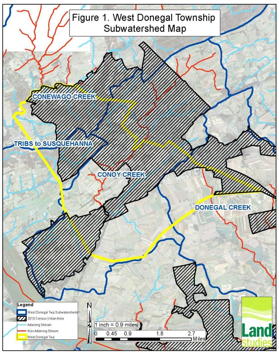
3 Introduction This pollutant reduction plan (PRP) was developed for as a requirement for their municipal separate storm sewer system (MS4). will be a new MS4 permittee starting in The PRP outlines the actions the Township will take to address pollutant loads to the waterbodies within the MS4 that drain to the Chesapeake Bay/impaired waters within the MS4. These actions include public participation, mapping of outfalls and other discharges, pollutant load calculations, best management practices (BMPs) selection, identification of potential funding sources and partners, and operations and maintenance (O&M) activities. A. Public Participation to be completed following Public Comment Period Public participation is an essential part of the PRP because it enhances buy-in from landowners that may have an impact on pollutant discharges, can uncover missing elements or errors in calculations, and builds cooperative partnerships among the municipality and other entities. A copy of the draft PRP was released via public notice on MONTH, DAY, YEAR to the following media outlets:. The notice ran for # days. A copy of the public notice is included as Item A-1. The public was given 30 days to provide commentary on the contents of the PRP. A copy of all written public comments is included as Item A-2. West Donegal Township held a public meeting on MONTH, DAY, YEAR to receive verbal commentary on the contents of the PRP. A copy of the comments and the record of consideration is included as Item A-3. used the public comments to update the draft PRP in the following ways:. B. Map is located entirely within the Chesapeake Bay Basin. The Conewago Creek watershed comprises approximately 20 percent of the Township (2,020 acres). The Conoy Creek watershed covers over 56 percent of the municipality with 5,714 acres. The Donegal Creek watershed and its tributaries account for approximately 14 percent of West Donegal Township (1,444 acres). The Tributaries to the Susquehanna River cover less than 10 percent of (971 acres). Figure 1 identifies the subwatershed basins within West Donegal, as well as impaired and attaining streams from the DEP 2014 Integrated List and the location of the 2010 Census Urban Area (UA). Additional maps are provided in Appendix B. Map B1 in Appendix B identifies the MapShed 2011 Land Use types throughout the Township, the MS4 outfall locations, and the storm sewershed boundaries grouped into Planning Areas. Approximately 52 percent of (5,317.3 acres) is Page 1
4 within the UA based on the 2010 U.S. Census data. Despite over half of the Township being included within the UA, only approximately 15 percent of this UA is impervious based on 2011 MapShed Land Use data. A significant portion of the UA is in agriculture or forested land use types. MapShed impervious surface cover by land use type includes the following ranges: Low Density Residential and Mixed Use: <30% impervious Medium Density Residential and Mixed Use: 30 75% Impervious High Density Residential and Mixed Use: >75% Impervious An additional map, Map B2 in Appendix B, identifies the Planning Areas for the Conewago Creek, Conoy Creek, Donegal Creek, and Tributaries to the Susquehanna River. It also includes the proposed location(s) of structural BMPs that will be implemented to achieve the required pollutant load reductions per watershed during the current permit cycle. Planning areas include all non-excluded areas on the maps and are primarily designated by subwatershed. B.1 Mapping of Planning Areas In accordance with DEP s guidelines, used the following process to parse areas and establish their MS4 planning area for the PRP. Prior to beginning PRP development, West Donegal went through a desktop and field verification exercise to establish inlets, outlets, pipes, swales and outfalls ( system ) within the Township. As part of PRP development, West Donegal s system mapping was added to a base map with National Hydrology Dataset (NHD) streams, topography, and watershed boundaries in order to aid in the field drainage boundary assessment to establish MS4 planning areas for the PRP. Mapping also included areas that could be parsed out such as state-owned road right of ways and industrial facilities covered by existing NPDES (National Pollutant Discharge Elimination System) industrial stormwater permits. The field review then continued to field verify outfalls on NHD streams with matching observed general drainage flow to the map; or to determine that the regulated system (inlets, curb and gutter, etc.) tied to the end point adequately collects stormwater run-off from the drainage areas reviewed. This process involves a visual tracing against the system map. The field review is supported by a condensed desktop reconfirmation analysis, where a topographic map or elevations of an aerial image, as well as the system map, are reviewed to determine the areas draining to outfalls and how these areas could be combined into planning areas that can be mapped in MapShed. Planning areas were then drawn to capture the drainage areas that are collected into the system and discharge via the outfall or group of outfalls within a watershed. Page 2
5 Within the UAs between these four drainage areas, there are over 1,800 acres of agricultural land and forested land that do not contain any MS4 infrastructure. These pervious areas that do not drain to the MS4 system have been parsed out of the planning areas. Additionally, there are pockets of development that do not drain to West Donegal s MS4 infrastructure, but drain as sheet flow or incidental dispersion into surrounding lands; thus, these areas have been parsed out of the planning areas. In total, 2,931 acres of UA were excluded from the planning areas based on the aforementioned rational (see Excluded Areas in Maps B1 and B2). NOTE: Excluded Areas are shown as overlays to the various planning areas displayed in Maps B1 and B2. Page 3
6 Page 4
7 C. Pollutants of Concern Since the waterways of ultimately drain to the Chesapeake Bay, the following are pollutants concern: sediment, total nitrogen (TN), and total phosphorus (TP). Because of this drainage to the Chesapeake Bay, the Township must prepare a CBPRP in accordance with Appendix D in the PAG-13 General Permit. also discharges stormwater to local impaired waters, including the Conewago Creek, Conoy Creek, and Donegal Creek and its tributaries. Therefore, it must reduce pollutant loads associated with those impairments and prepare an impaired waters PRP in accordance with Appendix E in the PAG-13 General Permit. Table 1 shows the affected subwatersheds within and the pollutant(s) that are of concern to the municipality as shown on the DEP MS4 requirements table revised 4/7/2017. Other impairments listed in Table 1 that are not addressed in this upcoming permit cycle will be considered in future permit cycles. Table 1. MS4 Requirements Table MS4 Planning Area / Watershed Pollutant(s) of Concern Conewago Creek Appendix E Nutrients, Suspended Solids (4a) Chesapeake Bay Nutrients / Sediment Appendix D Nutrients, Siltation (4a) Chiques Creek 1 Appendix E Nutrients (4a) Donegal Creek 2 (including Unnamed Appendix E Nutrients, Organic Tributaries to Donegal Creek) Enrichment / Low DO, Suspended Solids (4a) Conoy Creek Appendix B Pathogens (5), Appendix E Siltation (5) Susquehanna River Appendix C- PCBs (5) NOTE1: The Chiques Creek watershed does not lie within the boundaries of. The Donegal Creek watershed ultimately drains to the Chiques Creek; however, this confluence is located less than 1,000 feet from the connection to the Susquehanna River. Based on written approval from Scott Arwood from PADEP on 4/20/17, the Chiques Creek watershed was not included in s pollutant load calculations in this PRP due to the limited length of connection between the Donegal Creek and Chiques Creek before discharging to the Susquehanna River (Arwood, April 2017). NOTE2: The MS4 Requirements Table identifies Organic Enrichment / Low D.O. as Appendix E Pollutants of Concern for the Donegal Creek. Organic Enrichment and Low D.O. are surrogates for nutrient impairment. In accordance with DEP s PRP Instructions, this report is required specifically for stormwater discharges of nutrients and sediment to surface waters for the Chesapeake Bay (Appendix D) and impaired waters (Appendix E). Separate from the PRP, Pollutant Control Measures (PCMs) described in DEP s General Permit (3800-PM-BCW0100d) are to be implemented for Appendix A, B, and/or C pollutants of concern identified in the MS4 Requirements Table. Page 5
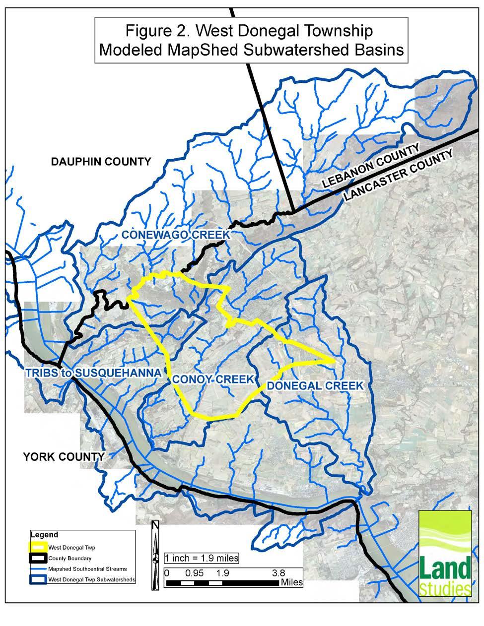
8 To address both the Appendix D and Appendix E requirements, will select BMPs to reduce the sediment pollutant load by 10 percent, which is assumed to then reduce the TN and TP by 3 percent and 5 percent respectively according to DEP s PRP Instructions (3800-PM-BCW0100k). Therefore, only sediment load reductions within the MS4 planning areas are reported in this PRP. As is subject to both a CBPRP and an impaired waters PRP, it will select BMPs that target the impaired waters discharges first, as action toward the local impaired waters will have a beneficial impact on the Chesapeake Bay. D. Existing Load for Pollutants of Concern West Donegal has three primary watersheds with impaired waters within the municipality: the Conewago Creek, Donegal Creek, and Conoy Creek. The existing load for West Donegal s Conewago Creek, Donegal Creek, Conoy Creek, and Tributaries to the Susquehanna River MS4 Planning Areas were calculated using MapShed Version West Donegal s Tributaries to the Susquehanna (including Snitz Creek) are not impaired waters; however, the pollutant loading from this drainage area must be addressed as part of the CBPRP load reduction requirements for the entire municipality. In order to model loads from MS4 Planning areas in MapShed base model runs of the following subwatersheds (shown in Figure 2) were run: Conewago Creek 52.5 square mile portion of the Lynch Run-Conewago Creek HUC12 subwatershed; Donegal Creek 17.2 square mile portion of the Donegal Creek HUC12 subwatershed; Conoy Creek 19.0 square mile portion of the Conoy Creek HUC12 subwatershed; Tributaries to the Susquehanna River square mile portion of the Hartman Run- Susquehanna River HUC12 subwatershed; Each planning area was digitized as an urban area in MapShed and the corresponding base model was rerun for this planning area. The MapShed UA tool was then used to establish the loading for each planning area. Only one contiguous UA could be run in MapShed per model run. Therefore, in order to keep the number of MapShed model runs reasonable, the planning areas were kept as large as possible within a watershed. Land use acreage and corresponding load adjustments were made to some of the MapShed model runs to account for excluded areas that were included in the modeled planning areas and vice versa where smaller islands of land that are included in the planning area could not reasonably be included in the model run. Screenshots of MapShed input and output for each planning area run are provided in Appendix C. Page 6
9 Page 7
10 D.1 Conewago Creek Watershed Existing Load Table 2 shows the sediment loading rates for each land use type for the Conewago Creek Model Run. Table 2. West Donegal MapShed Sediment Land Use Loading Rates Conewago Creek Loading MapShed Land Cover Rate (lb/ac) Total Load (lb) Hay/Pasture ,180 Cropland 0 0 Forest 9.8 7,673 Wetland Disturbed 0 0 Turfgrass 0 0 Open Land ,881 LD Mixed MD Mixed ,944 HD Mixed ,156 LD Residential MD Residential ,982 HD Residential 0 0 Water 0 0 Table 3. Existing load in the Conewago Creek Planning Area. Planning Total Acres Area Name (adjusted)* Conewago Creek Land Use Sediment Load (lbs) Streambank Sediment Load (lbs) Final Planning Area Existing Load (lbs) , , ,538 *Accounts for excluded areas and other acreage adjustments for the MapShed model run Based on these existing load calculations it was determined that the Conewago Creek Planning Area existing loading is 757,538 lbs. The minimum sediment reduction required for this Planning Area is 75,754 lbs. Page 8
11 D.2 Conoy Creek Watershed Existing Load Table 4 shows the sediment loading rates for each land use type for the Conoy Creek Model Run. Table 4. West Donegal MapShed Sediment Land Use Loading Rates Conoy Creek MapShed Land Cover Loading Rate (lb/ac) Total Load (lb) Hay/Pasture ,290 Cropland ,800 Forest 7.9 2,030 Wetland Disturbed Turfgrass 0 0 Open Land ,540 LD Mixed MD Mixed ,176 HD Mixed LD Residential MD Residential ,669 HD Residential 0 0 Water 0 0 Table 5. Existing load in the Conoy Creek Planning Area. Planning Total Acres Area Name (adjusted)* Conoy Creek Land Use Sediment Load (lbs) Streambank Sediment Load (lbs) Final Planning Area Existing Load (lbs) 1, , , ,565 *Accounts for excluded areas and other acreage adjustments for the MapShed model run Based on these existing load calculations it was determined that the Conoy Creek Planning Area existing loading is 573,565 lbs. The minimum sediment reduction required for this Planning Area is 57,356 lbs. Page 9
12 D.3 Donegal Creek Watershed Existing Load Table 6 shows the sediment loading rates for each land use type for the Donegal Creek Model Runs. Table 6. West Donegal MapShed Sediment Land Use Loading Rates Donegal Creek MapShed Land Cover Loading Rate (lb/ac) Total Load (lb) Hay/Pasture Cropland ,646 Forest 0 0 Wetland 0 0 Disturbed 0 0 Turfgrass 0 0 Open Land ,673 LD Mixed MD Mixed HD Mixed LD Residential 0 0 MD Residential ,520 HD Residential 0 0 Water 0 0 Table 7. Existing load in the Donegal Creek Planning Area. Planning Total Acres Area Name (adjusted)* Donegal Creek Land Use Sediment Load (lbs) Streambank Sediment Load (lbs) Final Planning Area Existing Load (lbs) ,996 97, ,045 *Accounts for excluded areas and other acreage adjustments for the MapShed model run Based on these existing load calculations it was determined that the Donegal Creek Planning Area existing loading is 125,045 lbs. The minimum sediment reduction required for this Planning Area is 12,505 lbs. Page 10
13 D.4 Tributaries to the Susquehanna River Existing Load Table 8 shows the sediment loading rates for each land use type for the Tributaries to the Susquehanna River Model Run. Table 8. West Donegal MapShed Sediment Land Use Loading Rates Tributaries to the Susquehanna River MapShed Land Cover Loading Rate (lb/ac) Total Load (lb) Hay/Pasture ,751 Cropland ,682 Forest ,232 Wetland Disturbed 0 0 Turfgrass 0 0 Open Land 141 2,115 LD Mixed MD Mixed 0 0 HD Mixed LD Residential 0 0 MD Residential ,407 HD Residential 0 0 Water 0 0 Table 9. Existing load in the Tributaries to the Susquehanna River Planning Area. Planning Area Total Acres Name (adjusted)* Tributaries to the Susquehanna Land Use Sediment Load (lbs) Streambank Sediment Load (lbs) Final Planning Area Existing Load (lbs) , , ,605 *Accounts for excluded areas and other acreage adjustments for the MapShed model run Based on these existing load calculations it was determined that the Tributaries to the Susquehanna River Planning Area existing loading is 219,605 lbs. The minimum sediment reduction required for this Planning Area is 21,961 lbs. Page 11
14 D.5 s Total Aggregated Existing Load will be a new MS4 permittee in In the process of developing their Stormwater Management Program (SWMP), the Township has not identified any existing stormwater BMPs that can be utilized in this PRP to reduce the existing loading rates within the planning areas. West Donegal received approval from DEP on June 8, 2017 to aggregate all of the watershed planning area loads for the municipality into a total aggregated load for (Arwood, June 2017). Table 10 shows planning area loads and the total aggregated load for. Table 10. Total Existing Load for. Planning Area Name Final Planning Area Existing Load (lbs) Conewago Creek 757,538 Conoy Creek 573,565 Donegal Creek 125,045 Tribs. to Susquehanna 219,605 Total Aggregated Load for West Donegal Twp 1,675,753 10% Sediment Reduction Requirement for Aggregated Load 167,575 E. BMPs Selected to Achieve the Minimum Required Reductions in Pollutant Loading Based on the 10% sediment reduction targets established above, has identified a strategy to meet the minimum load reductions within 5 years following DEP s approval of permit coverage. The nutrient reduction requirements for the impaired waters are assumed to be addressed by the 10 percent sediment reductions. Summary of Alternatives and Selection of BMPs evaluated approximately eight stormwater BMP projects and approximately ten stream restoration projects considering the following criteria: Sediment reductions Cost per pound of pollutant reduction Ownership (public versus private land) Funding and Workforce availability Page 12
15 Community benefit (site accessibility, visibility to the public, ability of public to experience benefits) Connectivity to other completed or proposed stormwater BMPs Timeframe to implement The purpose of the evaluation was to determine the BMPs that would reduce the most pollutants for the least amount of money while getting closer to the goal of removing streams from the impaired waters list and protecting the Chesapeake Bay. The Township determined that there are limited opportunities to implement stormwater BMPs throughout the municipality that can satisfy the PRP load reduction requirements; however, there is one stream restoration project along the Conoy Creek that provides an opportunity to significantly reduce streambank erosion and sediment loading in the watershed. The highest priority BMPs evaluated by are various sections of Conoy Creek stream restoration that are summarized in Table 11 as potential BMPs that could be implemented to satisfy the load reduction requirements. BMP ID Number 1A 1B 1C Table 11. Proposed BMPs for BMP Project Sediment Load Reduction (lbs) Conoy Creek Stream Restoration Project on 178,250 Parcel ID#s , and Conoy Creek Stream Restoration Project on 178,250 Parcel ID# Conoy Creek Stream Restoration Project on 178,250 Multiple Parcels Total 178,250 (per BMP) Required 167,575 is not committing to implementing a stream restoration project that would cover the entire reach of stream on the properties listed above as that would exceed their required deduction. The final selection of the length and location of the stream restoration will be based on detailed design criteria, cost, and landowner coordination. The chosen BMP(s) will meet the 10 percent required sediment reduction and will be implemented by the end of the five-year permit cycle. BMP 1A - Conoy Creek Stream Restoration Project on Parcel ID#s , and is considering a stream restoration project of approximately 1,550 LF that would be implemented along Conoy Creek. According to the DEP PRP Instructions, a 115 lb. /ft. sediment load reduction can be applied to this project resulting in 178,250 lbs. Page 13
16 of sediment reduction for the total project. This reach of stream is located near Miller Road in Elizabethtown along three private properties: Shippling (Parcel # ); Smith (Parcel # ); Childs (Parcel ID# ). This project will require coordination with these private landowners. The exact location and length of this stream restoration project will be based on the final design details. BMP 1B - Conoy Creek Stream Restoration Project on Parcel ID# As an alternative to BMP 1A, is considering a stream restoration project of approximately 1,550 LF that would be implemented along Conoy Creek. This reach of stream is located only on the Childs property (Parcel ID# ) identified above. As with BMP 1A, a 115 lb. /ft. sediment load reduction can be applied to this project resulting in 178,250 lbs. of sediment reduction for the total project. The exact location and length of this stream restoration project will be based on the final design details. BMP 1C - Conoy Creek Stream Restoration Project on Multiple Parcels As third alternative, is considering a stream restoration project of approximately 1,550 LF that would be implemented along Conoy Creek. This reach of stream is located near Miller Road in Elizabethtown and may include any of the following properties: Shippling (Parcel # ); Smith (Parcel # ); Childs (Parcel ID# ); Heisey (Parcel ID# ); and Aungst (Parcel # ). This project will require coordination with these private landowners. As with BMPs 1A and 1B, a 115 lb. /ft. sediment load reduction can be applied to this project resulting in 178,250 lbs. of sediment reduction for the total project. The exact location and length of this stream restoration project will be based on the final design details. F. Funding Mechanism Identification In order to install and maintain the BMPs listed in Section E, West Donegal proposes the following sponsors/partners and funding sources. BMP# 1A 1B 1C Table 12. BMP funding Sources Sponsor/Partner/Funding Sources West Donegal budget funds, local business tax; DCNR, DEP, NFWF are potential grant sources for installation; West Donegal budget funds, local business tax; DCNR, DEP, NFWF are potential grant sources for installation; West Donegal budget funds, local business tax; DCNR, DEP, NFWF are potential grant sources for installation; Page 14
17 G. Responsible Parties for Operation and Maintenance (O&M) of BMPs All stormwater BMPs installed under this PRP are subject to West Donegal s stormwater management ordinance. The Operation and Maintenance (O&M) activities for each BMP are included in the table below. If the BMP is located on private land, the landowner must convey an easement to the Township to allow for access for periodic inspections and maintenance, as needed. Actual O&M activities will be listed in the Annual MS4 Status Report sent to the PADEP under the General Permit. BMP # 1A 1B 1C Table 13. BMP O&M Activities Parties Responsible for O&M Activities O&M Township Public Works Department and maintenance staff, as coordinated with the landowner; Township Public Works Department and maintenance staff, as coordinated with the landowner; Township Public Works Department and maintenance staff, as coordinated with the landowner; Inspection in accordance with stream restoration design details; Inspection in accordance with stream restoration design details; Inspection in accordance with stream restoration design details; Frequency for O&M Activities Biannual inspections for first three years and annual inspections thereafter. Additional inspections following large storm events; Additional O&M activities will be detailed in the final design; Biannual inspections for first three years and annual inspections thereafter. Additional inspections following large storm events; Additional O&M activities will be detailed in the final design; Biannual inspections for first three years and annual inspections thereafter. Additional inspections following large storm events; Additional O&M activities will be detailed in the final design; Page 15
18 H. Works Cited Arwood, Scott (PADEP). Re: Individual MS4 Permit. Message to Emily West. 08 June Arwood, Scott (PADEP). Re: MS4 Requirements Table. Message to Emily West. 20 April Integrated Water Quality Report Integrated List of All Waters (formerly 303(d) Report). Retrieved February 8, 2017, from Quality-Report-2014.aspx. Office of Water Management, Bureau of Water Supply & Wastewater Management, Water Quality Assessment and Standards Division. Schueler, T. and C. Lane. January 20, Recommendations of the Expert Panel to Define Removal Rates for Urban Stormwater Retrofit. Chesapeake Bay Program Urban Stormwater Workgroup. Pennsylvania Department of Environmental Protection (PADEP) PRP / TMDL Plans MS4 Workshop. Harrisburg, PA. Page 16
19 Appendix A Public Participation: Item A1. Public Notice; Item A2. Written Public Comments; Item A3. Record of Consideration of Written Public Comments
20 Appendix B Map B1. Land Use Types and Planning Areas; Map B2. MS4 PRP Map

21

22
23 Appendix C Summary of MapShed Runs and MapShed Inputs and Results
24 Conewago Creek Baseline Watershed Input and Results The following screenshots represent the input for the baseline watershed model. The following data was customized in this model run: Percent bank fraction was adjusted so soil nutrient concentration match what is included in the Recommendation of the Expert Panel to Define Removal Rates for Individual Stream Restoration Projects (2014). N 2.28 lb/t and P 1.05 lb/t Groundwater concentrations were customized based on data acquired from the Groundwater Monitoring Network data downloaded from the PADEP Wave GIS tool accessed on April 21, No rural or urban BMP data, point source or animal data was included in the model run. Conewago Creek Baseline Watershed Results
25 Conewago Creek Baseline Watershed Transport Data
26 Conewago Creek Baseline Watershed Nutrient Data
27 Conoy Creek Baseline Watershed Input and Results The following screenshots represent the input for the baseline watershed model. The following data was customized in this model run: Percent bank fraction was adjusted so soil nutrient concentration match what is included in the Recommendation of the Expert Panel to Define Removal Rates for Individual Stream Restoration Projects (2014). N 2.28 lb/t and P 1.05 lb/t Groundwater concentrations were customized based on data acquired from the Groundwater Monitoring Network data downloaded from the PADEP Wave GIS tool accessed on April 21, No rural or urban BMP data, point source or animal data was included in the model run. Conoy Creek Baseline Watershed Results

28 Conoy Creek Baseline Watershed Transport Data
29 Conoy Creek Baseline Watershed Nutrient Data
30 Donegal Creek Baseline Watershed Input and Results The following screenshots represent the input for the baseline watershed model. The following data was customized in this model run: Percent bank fraction was adjusted so soil nutrient concentration match what is included in the Recommendation of the Expert Panel to Define Removal Rates for Individual Stream Restoration Projects (2014). N 2.28 lb/t and P 1.05 lb/t Groundwater concentrations were customized based on data acquired from the Groundwater Monitoring Network data downloaded from the PADEP Wave GIS tool accessed on April 21, No rural or urban BMP data, point source or animal data was included in the model run. Donegal Creek Baseline Watershed Results
31 Donegal Creek Baseline Watershed Transport Data

32 Donegal Creek Baseline Watershed Nutrient Data

33 Tributaries to the Susquehanna River Baseline Watershed Input and Results The following screenshots represent the input for the baseline watershed model. The following data was customized in this model run: Percent bank fraction was adjusted so soil nutrient concentration match what is included in the Recommendation of the Expert Panel to Define Removal Rates for Individual Stream Restoration Projects (2014). N 2.28 lb/t and P 1.05 lb/t Groundwater concentrations were customized based on data acquired from the Groundwater Monitoring Network data downloaded from the PADEP Wave GIS tool accessed on April 21, No rural or urban BMP data, point source or animal data was included in the model run. Tributaries to the Susquehanna River Baseline Watershed Results
34 Tributaries to the Susquehanna River Baseline Watershed Transport Data
35 Tributaries to the Susquehanna River Baseline Watershed Nutrient Data
36 MapShed Planning Area UA Tool Results The exact same inputs used for the baseline watershed model runs were used for their respective planning area model runs. The Urban Areas digitized for the model runs captured as much acreage as possible while excluding as much of the parsed ground as was reasonably possible to get the most accurate loading rates. In some cases, land use acreage adjustments were still necessary to exclude parsed area and include islands of planning area that weren t captured in the model run. The total loads for each planning area and acreage adjustments are shown in the Existing Loads section of the PRP. Screen shots of the UA Tool for each Urban Area MS4 Planning Area Run are provided below.
37 Conewago Creek Planning UA
38 Conoy Creek Planning UA
39 Donegal Creek Planning UA

40 Tributaries to the Susquehanna River Planning UA
41 Appendix D Proposed BMP Inventory
42 West Donegal Townhip Stream BMPs - Sediment Reduction Calculations* BMP ID# Site Length (ft) Sediment Removal (lbs) 1A Conoy Creek Stream Restoration Project on Parcel ID#s , and , B Conoy Creek Stream Restoration Project on Parcel ID# , C Conoy Creek Stream Restoration Project on Multiple Parcels , *Sediment Load Reductions Calculated at 115 lbs./lf Based on PADEP's PRP Instructions 10% Reduction Requirement 167,575