Application of Satellite Rainfall Monitoring in Flood Management of Indus River
|
|
|
- Meredith Richard
- 5 years ago
- Views:
Transcription
 UNESCO Monitoring the global water cycle and climate change -- its application to the society 4 December 2015 COP21 Japan")
1 Application of Satellite Rainfall Monitoring in Flood Management of Indus River Takahiro Konami Hydrological Systems and Water Scarcity Section International Hydrological Programme (IHP) UNESCO Monitoring the global water cycle and climate change -- its application to the society 4 December 2015 COP21 Japan Pavilion
2 Water Security: key challenges of the 21st century [Key Facts] 6-8 million human beings are killed each year from water related disasters and diseases. 750 million people lack access to safe water and 2.5 billion to adequate sanitation. 85% of the human population live in arid areas. By 2030, half of the population will be living in areas of high water stress. *Inventoried by UNESCO-IHP 2
3 Water Security: key challenges of the 21st century [Key Facts] Almost 85% of the world s total wastewater is discharged without adequate or any treatment. In just thirty years, populations of freshwater species declined by 50% 145 nations have transboundary river basins and there are 445 transboundary aquifers shared by 2-4 countries *Inventoried by UNESCO-IHP 3
; Intergovernmental Oceanographic Commission (IOC); Man and the Biosphere")


4 General Description of IHP Education Sector Sciences Sectors Culture Sector Social and Human Sciences Natural Sciences International Hydrological Programme (IHP); Intergovernmental Oceanographic Commission (IOC); Man and the Biosphere Programme (MAB); International Geosciences Programme (IGCP); International Basic Sciences Programme (IBSP). International Hydrological Programme is - UNESCO s Intergovernmental Scientific Cooperative Programme in Hydrology and Water Resources - The only intergovernmental programme of the UN system devoted to water research, water resources management, and education and capacity building - Established in 1975, now that prepared the eighth phase of IHP (IHP-VIII) for

5 IHP-VIII : 6 Themes, 3 Axes


6 2015: SDG, COP-21, Water Forum, DRR 7th World Water Forum Korea April Conference Our Commun Future Paris July Sustainable Development goals September 3rd World DRR conference Sendai March COP21 Paris, France, December, 2015 IHP VIII Programmes and Initiatives 6
 Water-related")
7 UNESCO IHP Network Water-related Institutes and Centres(18) Water-related Chairs(29) 7
8 Pakistan Flood Project "Strategic Strengthening of Flood Warning and Management Capacity of Pakistan" (Funded by the Government of Japan) 8
 Reconstruction cost : US$8.74-10.")
9 Executive summary of the 2010 floods in Pakistan Flood affected area : 78/121 districts(64%) Population affected : 20 million (1/9 of population) Deaths : 2000 approx. Injured : 3000 approx. Houses damaged : 1.6 million Area affected : 100,000 km2 Economic losses : US$10.0 billion (Direct 6.5billion, Indirect3.6billion) Reconstruction cost : US$ billion Worst Floods in about 100 years 9
Based on the mission to Pakistan, UNESCO prepared response project with the Pakistani authorities to reinforce the country s capacity in: integrated flood and watershed management groundwater")
10 UNESCO Post 2010 Floods Actions in Pakistan 1) UNESCO DG sent a team of flood management experts to Pakistan on 22 nd August )Based on the mission to Pakistan, UNESCO prepared response project with the Pakistani authorities to reinforce the country s capacity in: integrated flood and watershed management groundwater resources for emergency situations landslides and ground instability especially for relocation of affected population. 3)UNESCO operates two projects* in Pakistan with total funding of USD 7.7 Million funded by the Government of Japan. *Phase I from August 2011 and Phase II from March


![of INDUS] Catchment Area: 1,140,000km 2 Length of mainstream: 2,800km *Source: ADB](/docs-images/88/116988734/images/11-4.jpg "report(2013) Karachi [Resent major floods] 2010: 2,000 died, >20mil affected 2011: 509")


11 Pakistan Flood Project Strategic Strengthening of Flood Warning and Management Capacity of Pakistan TURKMENISTAN UZBEKISTAN TAJIKISTAN CHINA Utilizing Satellite Based Technologies IRAN Khyber Pakhtunkhwa Gilgit Baltistan Azad Kashmir Integrated Flood Analysis System AFGANISTAN Kabul Peshawar Srinagar Islamabad Jammu and Kashmir [Features of INDUS] Catchment Area: 1,140,000km 2 Length of mainstream: 2,800km *Source: ADB report(2013) Karachi [Resent major floods] 2010: 2,000 died, >20mil affected 2011: 509 died, 5.4mil affected 2012: 480 died, 5mil affected 2013: 234 died, 1.5mil affected 2014: 367 died, 2.5mil affected *Source: Phase 1 final report (2010) and EM-DAT( ) Balochistan Sindh FATA PAKISTAN Hyderabad Punjab Lahore Amritsar INDIA Punjab Haryana Himachal Pradesh Shimla 0km Uttarakhand Major OUTCOMEs of the Phase 1 Practical model for flood forecast in upper Indus and Kabul river basin was established utilizing GSMaP and IFAS Flood and Inundation simulation in lower Indus basin was developed with IFAS and RRI. * Project cost : $3.7mil Project term: Aug 2011-Sep 2014 GOALs of the Phase 2 - Establishment of the technical foundation for sustainable capacity development on the flood management, forecasting, early warning and flood hazard analysis in Pakistan agencies * Including an extension of the Phase-1 system to the Eastern Rivers of Indus [dotted red line] - Technical studies to promote strengthening of cooperation with Indus river basin countries for transboundary flood management and transboundary data sharing - Capacity building and education to community on flood management for proper utilization of flood hazard information and tools * Project cost : $4.1mil Project term : Apr 2015-Sep 2017 Rainfall-Runoff- RRI Inundation Model 11

12 Implementation Framework of Pakistan Flood Project (Phase 1) Pakistan Authorities PMD Development of Flood Forecasting System Component: A1 Data support PCRWR Soils and Hydrological data Flood forecasting and early warning system Hazard mapping Experts UNESCO Network UNESCO Project Implementation International Partners UNESCO International Network SUPARCO Flood Risk Hazard Mapping NDMA (Including NIDM) National Policy and Flood Management at National, Province, District level GSMaP Local Calibration *Satellite based rainfall UNESCO Water Center ICHARM International Centre for Water Hazard and Risk Management under the auspices of UNESCO FFC Coordination for flood management at provincial level JAXA Japan Aerospace Exploration Agency Indus River Commission Transboundary Data sharing 12
 Flood")


 3B42RT(V5) QMORPH")


13 Integrated Flood Analysis System (IFAS) Flood forecasting system using satellite data input Global Geological data for modeling Elevation data, Land use data, etc. Ground rainfall and Satellitebased rainfall GSMaP_NRT GSMaP_MVK+ 3B42RT(V6) 3B42RT(V5) QMORPH CMORPH Courtesy of JAXA Run-off analysis Surface model River discharge, Water level, Rainfall distribution Integrated Flood Analysis System Model creation Aquifer model River course model Calculation Flow/water level Flood forecasting/warning Promoting safe evacuation Reduce/Prevent flood damage 13

14 Utilization of GSMaP 14

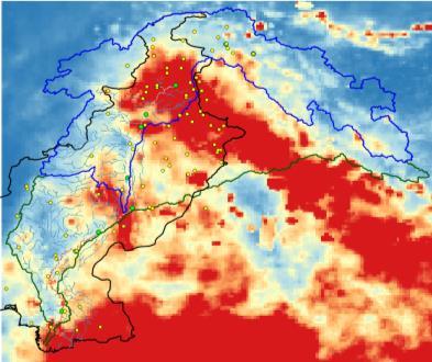
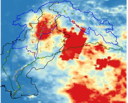


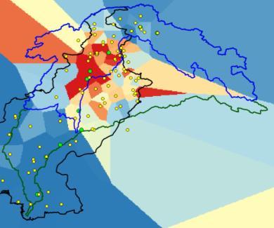


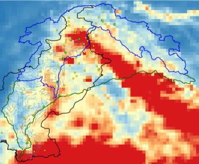

15 Customization of GSMaP Ground observatory data (Thiessen method) 2015/6/1-9/30 July August 2015/8/2 GSMaP_NRT (Near Real-Time) Corrected GSMaP with ground data (GSMaP_IF2) 15

16 Project Component of Phase 1 16

17 Project Component of Phase 1 On FFD WEBSITE: RRI RESULTS 2014 at Guddu 17


18 Project Component of Phase 1 Enable show BHUs, Settlements, Roads, Schools, Agriculture and Bridges with layers 18


19 Phase 2: Partners meeting in Jakarta "Post audit of flood forecasting models and charting of future collaborations" GrandKemang Hotel, Jakarta, Indonesia November days workshop for post-audit of 2015 flood simulation performance, visibility strategy and political engagement process with ICHARM, JAXA, PMD, PCRWR and Pakistani universities (NUST, UET-Lahore, University of Peshawar). UNESCO 70 th Anniversary Indus-IFAS simulation results for 2015 flood, ICHARM Presentation from Flood Forecasting Division, PMD 19
20 Other IHP Networks 20

21 International Flood Initiative (IFI) Develops capacity building to better understand and respond to floods hazards while taking advantage of their benefits Focus on research, information networking, education and training to empower communities 21
22 International Drought Initiative (IDI) Platform of global networking and knowledge sharing between international entities: Surveys drought management; collects information; helps affected countries; develops capacity building; strengthens public participation and, promotes regional and international cooperation on drought issues. 22
23 Case Studies : Africa and LAC Droughts Monitors Strengthen the capacity of African and LAC countries for near real-time monitoring and seasonal forecasting; to raise awareness of the impact of drought on vulnerable and disadvantaged groups. 23
24 Global Network on Water and Development Information for Arid Lands: G-WADI Improved understanding of the characteristics of hydrological systems and water management needs in arid areas Capacity building of individuals and institutions Broad dissemination of information to the user community and the public Exchange of experience Promoting integrated basin management and the development and use of appropriate decision support tools 24

25 G-WADI Website: 25

26 FRIEND: Flow Regimes from International Experimental and Network Data - Water A network of scientists and water managers: Regional water resources Water-related disasters Global change; water cycle Water education and capacity building 26
27 Snow and Ice Networks Regional Workshop: Assessment of Snow-Glacier and Water Resources in Asia November 2006, Almaty, Kazakhstan Working Group on Snow, Ice and Glaciers (GTNH)-LAC High Level Panel session: Climate Change Impacts on Water Resources and Adaptation policies in Mountainous regions 13-November 2013, 37 th General Conference 27
 USGS JAXA (4 November-20 December at UNESCO HQ)")
28 Exhibition: Mountains: early warning systems for climate change January 1976 by USGS March 2009 by JAXA (ALOS) USGS JAXA (4 November-20 December at UNESCO HQ) 28
29 Thank you!