Remote Sensing Applications for Flood Management in ADB TA8074-REG
|
|
|
- Rosa Powell
- 5 years ago
- Views:
Transcription
1 Remote Sensing Applications for Flood Management in ADB TA8074-REG Presentation by Yusuke Muraki Infrastructure Specialist (Space Technology) Asian Development Bank 20 November


,")

2 Contents Share the status of ADB s technical assistance project Applying Remote Sensing Technology in River Basin Management (ADB TA8074-REG), which applies satellite remote sensing data for flood management. 2
3 Project Overview TA-8047 REG Applying Remote Sensing Technology in River Basin Management JFPR funded, 2 million US$ Philippines, Bangladesh, and Viet Nam 2012/4 to 2015/3 Impact: reduction in losses from flooding events Outcome: improved river basin management including flood risk management using Space Based Technology (SBT) and ICT Output: (i) SBT and ICT applied for flood risk management (ii) Selected staff able to apply SBT and ICT in river basin management. 3 Satellite-based Rainfall Data

4 Application of Satellite-based Rainfall Data 4
 Needs local calibration with ground rain gauge stations Images provided by")
5 Application of Satellite-based Rainfall Data Global Rainfall Map in Near Real Time by JAXA (Around 10 km x 10 km) Needs local calibration with ground rain gauge stations Images provided by JAXA 5
 10km x 10km area around Kulkandi union, Islampur Upazila, Jamalpur district b) 10km x 10km area around Jadur Char union, Roumari")
6 Target area in Bangladesh Dhubri Pandu Guwahati (uppest Goalpara river-gauge in India) 1. GSMaP application Jadur Char union - Jamuna River (inc. upstream in Indian and Chinese side) Kulkandi union 2. local flood modeling, location-based SMS, and Evacuation training a) 10km x 10km area around Kulkandi union, Islampur Upazila, Jamalpur district b) 10km x 10km area around Jadur Char union, Roumari Upazila, Kurigram district 6
")

")
 Once a day Bangladesh Water Development Board")
7 Flood models with input of satellite rainfall data in Bangladesh GSMaP (Satellite Rainfall) Automatic Internet Automatic Rain Gauges Automatic Intranet GSMaP Flood Local flood Calibration Model model Auto run 24 hours Flood Forecasting and Warning Center (FFWC) WebGIS Manual Operation by FFWC staff (IWM staff ) Once a day Bangladesh Water Development Board (BWDB) Internet Users 7

8 SMS-based Flood Warning Dissemination System in Bangladesh National Disaster Management Committee (DMC) Department of Disaster Management (DDM) FFWC/BWDB WebGIS District DMC Upazila DMC 3. When evacuation is needed, issue evacuation order for selected unions Union level flood warning by SMS 1. Everyday, FFWC staffs check the local flood model on WebGIS 2. When the model shows that the union will be inundated in X days, prepare and send SMS as pre-alert. Union DMC Union Info. Center 4. Lead evacuation of citizens at Union level. Union level warning/evacuation order, etc by human, through Citizens speaker at mosque, etc 8

9 Blue: Introduced in TA Data Input NHMS Rain Gauges New Rain Gauges GSMaP NHMS River Gauges New River Gauges Target area Red River Basin (Ha Hoa in Phu Tho province) Viet Nam Creation/Distribution of Flood Warning MONRE Administration NHMS National Center GSMaP Calibration Rain fall WEB-DHM Discharge H-Q conversion Water Level Flood forecast Other outputs of TA Strategies, guidelines, and programs for flood risk reduction applying SBT and ICT Strengthened staffs and stakeholders capacities through training and workshops Flood Bulletin by Fax, , Website Information Dissemination to Citizens CCFSC & Other Government Agencies Standing Office (MARD DWR/DDMFSC) NHMS Regional/ Provincial Centers Media Citizens EVACUATION Local Authorities (DARD, etc) Web-based GIS SMS Warning Dissemination System Flood Warning by SMS GSMaP : Global Satellite Mapping of Precipitation

10 Target area in Viet Nam Target Area: Red-THao River basin Lao Cai Yen Bai Viet Tri Ha Noi
 live in outside of dike system Phu Tho Viet Tri")
11 Target area in Viet Nam Target Area: Thao River basin Pilot area(sms and flood forecast): Ha Hoa in Phu Tho province Yen Bai Ha Hoa 21,000 families (5 persons/family) live in outside of dike system Phu Tho Viet Tri 11

12 New rain gauge and water level gauge installation New automatic telemated rain gauges will be installed for GSMaP calibration. New water level gauge will be installed in Ha Hoa for validation of flood model. Water level gauges in Lao Cai and Yen Bai will be upgraded. The number of gauges installation will decided based on the cost estimate. Lao Cai New Automatic Rain gauge New Automatic water level gauge VanBan Yen Bai Ha Hoa Phu Loo Ngoc Pong Xuan Dai Viet Tri 12
 Flood warning information Other outputs of TA Strategies, guidelines, and programs for flood risk reduction applying SBT and ICT Strengthened staffs and")
13 Philippines Data Input Flood prediction Output PAGASA Rain Gauges New Rain Gauge GSMaP Target area Cagayan River Basin PAGASA HQ GSMaP Calibration Interface of Calibrated GSMaP to flood models Flood models IFAS (Integrated Flood Analysis system) Flood warning information Other outputs of TA Strategies, guidelines, and programs for flood risk reduction applying SBT and ICT Strengthened staffs and stakeholders capacities through training and workshops Blue: Introduced in TA GSMaP : Global Satellite Mapping of Precipitation 13

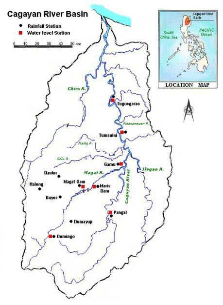
14 Target area 14

15 New rain gauges 15
16 Lessons Learned Importance of thinking about how output could be practically used by users. Output is water level from the flood model. Outcome is to mitigate damage by providing the alert to citizens. Important to support the following Clarify meaning of output make guideline to interpret Accessibility of output for users make website 16


17 Conclusion Under TA8074, ADB has been developing the methodology of calibrating GSMaP in the target rivers of Bangladesh, Philippines and Viet Nam. The systems in Bangladesh and Philippines have been developed and work in Viet Nam is ongoing. 17

18 Thank you! If you have any questions, please contact Yusuke Muraki 18