Ashland. Environmental Assessment Bus Rapid Transit. November Prepared for: The Federal Transit Administration 79th. Prepared by.
|
|
|
- Wendy Craig
- 5 years ago
- Views:
Transcription

1 Irving Park Addison Roscoe Belmont in partnership with Diversey Fullerton Cortland North Chicago Grand Lake Madison Jackson Harrison Polk Roosevelt 18th Blue Island 31st 35th Environmental Assessment Bus Rapid Transit Ashland Division November 2013 Pershing 43rd 47th 51st Garfield 59th 63rd 69th 74th Prepared for: The Federal Transit Administration 79th 83rd 87th 91st 95th Prepared by

2 Ashland Avenue Bus Rapid Transit Project November 14, 2013
3
4
5
6 Table of Contents EXECUTIVE SUMMARY...ES-1 Purpose and Need... ES-1 Environmental Resources, Impacts and Mitigation... ES-2 Opportunity for Public Comment... ES-5 1. PURPOSE AND NEED Introduction Project Background Needs to be Addressed Project Purpose ALTERNATIVES CONSIDERED Alternatives Development Process No-Build Alternative Build Alternative TRANSPORTATION CONDITIONS AND ANALYSIS Traffic Analysis Traffic Mitigation Parking Impact Analysis Transit Operational Analysis AFFECTED ENVIRONMENT AND ENVIRONMENTAL CONSEQUENCES Displacements and Relocation of Existing Uses Land Use and Economic Development Neighborhoods and Communities Historical and Archaeological Resources Parklands and Recreational Resources Visual Quality Noise and Vibration Air Quality Water Resources Biological Resources Geology and Soils Page i
7 4.12 Hazardous Materials Energy Safety and Security Environmental Justice Communities Temporary Construction Impacts Indirect Effects and Cumulative Impacts AGENCY COORDINATION AND PUBLIC INVOLVEMENT Agency Coordination Public Involvement Plan EA Distribution and Public Comment Period REFERENCES List of Figures Figure 1-1: Study Area Overview Map... 6 Figure 2-1: No-Build Alternative Figure 2-2: Build Alternative (Preferred Alternative) Figure 2-3: Ashland Avenue BRT Project Phasing Limits Figure 3-1: Right-of-Way and Street Width Extents Figure 3-2: Typical Existing Ashland Avenue Roadway Configuration Figure 3-3: Typical Proposed Ashland Avenue Roadway Configuration Figure 3-4: Diversion Analysis Study Area Figure 3-5: Existing and Build Conditions AM Peak Hour Level of Service (1 of 2) Figure 3-6: Existing and Build Conditions AM Peak Hour Level of Service (2 of 2) Figure 3-7: Existing and Build Conditions PM Peak Hour Level of Service (1 of 2) Figure 3-8: Existing and Build Conditions PM Peak Hour Level of Service (2 of 2) Figure 3-9: Existing and Mitigated (inside curb-to-curb) Build Conditions AM Peak Hour Level of Service (1 of 2) Figure 3-10: Existing and Mitigated (inside curb-to-curb) Build Conditions AM Peak Hour Level of Service (2 of 2) Figure 3-11: Existing and Mitigated (inside curb-to-curb) Build Conditions PM Peak Hour Level of Service (1 of 2) Figure 3-12: Existing and Mitigated (inside curb-to-curb) Build Conditions PM Peak Hour Level of Service (2 of 2) Figure 4-1: Existing Land Use (1 of 2) Figure 4-2: Existing Land Use (2 of 2) Figure 4-3: Intersecting Neighborhoods (1 of 2) Figure 4-4: Intersecting Neighborhoods (2 of 2) Page ii
8 Figure 4-5: Parklands (1 of 2) Figure 4-6: Parklands (2 of 2) Figure 4-7: Current Visual Conditions at Select Intersections along Ashland Avenue Figure 4-8: Build Alternative Station and Alignment Concepts List of Tables Table ES-1: Summary of Impacts... ES-2 Table 2-1: No-Build Alternative Transit Operational Service Characteristics Table 2-2: Phase 1 Implementation Schedule (Cortland Street to 31 st Street) Table 2-3: Phase 2 Implementation Schedule (31 st Street to 95 th Street and Cortland Street to Irving Park Road) Table 3-1: Existing Ashland Avenue Right-of-Way and Curb-to-Curb Widths Table 3-2: Percent Change between Existing Conditions and Build Conditions by Routes Table 3-3: Percent Change between Existing Conditions and Build Conditions by Corridors Table 3-4: Categorization of Level of Service Table 3-5: Ashland Avenue Existing Deficient Intersection LOS and Intersection Delay (in seconds) Table 3-6: Ashland Avenue Unacceptable LOS and Delay (in seconds) Table 3-7: Ashland Avenue Intersection LOS and Delay (in seconds) with Mitigation Table 3-8: Ashland Avenue Average Parking Demand Table 4-1: Ashland Avenue Demographic Profile Summary Table 4-2: Parks Adjacent to Ashland Avenue Corridor Table 4-3: Noise Level Impact Summary Table 4-4: Summary of Environmental Justice Populations by Community Area Appendices Appendix A: Alternatives Analysis Supporting Materials Appendix B: Traffic Analysis Supporting Documentation Appendix C: Parking Supply and Demand Analyses Appendix D: Transit Operational Analysis Supporting Documentation Appendix E: Supporting Environmental Technical Memorandums Appendix F: Agency Coordination Supporting Materials Appendix G: Conceptual Engineering Plans Appendix H: Public Involvement Appendix I: List of Acronyms Page iii
9 This page intentionally left blank Page iv
10 EXECUTIVE SUMMARY The Chicago Transit Authority (CTA), in cooperation with the Chicago Department of Transportation (CDOT), and as a grantee of the Federal Transit Administration (FTA), is proposing to implement an approximately 16.1-mile long Bus Rapid Transit (BRT) service along Ashland Avenue in the City of Chicago to improve transit speeds and reliability and enhance the pedestrian environment. The project corridor extends north-south along Ashland Avenue from Irving Park Road in the north to 95 th Street in the south. Physical improvements proposed include dedicating two general use travel lanes (one in each direction) as center running busonly lanes, implementation of transit signal priority (TSP), and construction of median BRT stations with enhanced pedestrian amenities approximately every half mile and at CTA L stations. This (EA) documents the effects of implementing these improvements along the entire 16.1-mile project corridor. Phase 1 of the project would implement center running, dedicated bus-only lanes and median stations first along 5.4 miles of Ashland Avenue between Cortland Street in the north and 31 st Street in the south, generally within the central portion of the full 16.1-mile project. Outside of the Phase 1 limits, the BRT service would operate in mixed flow traffic and make stops curbside at the BRT station locations, using existing curbside local bus stops for the remainder of the 16.1-mile corridor. The second phase of the project would be implemented commensurate with funding availability. An implementation plan for the two project phases is discussed within this report (see Section 2.3). This EA has been developed to meet the requirements of the National Environmental Policy Act of 1969 (NEPA) and concentrates on a detailed assessment of social, economic, and environmental impacts. It also recommends mitigation measures for any identified adverse impacts. In coordination with the public involvement process, the EA helps to define the effects of implementing the Ashland Avenue BRT Project on the physical, human, and natural environments along the corridor and surrounding station locations. The selection of this center running, travel lane removal alternative as the Preferred Alternative (the Build Alternative in this EA) was based on a year-long Alternatives Analysis (AA) effort that assessed more than 16 options for BRT on Ashland Avenue. After a multi-level screening analysis and input at six public open houses, center running BRT with the removal of one travel lane in each direction was identified as the Preferred Alternative. Construction of the project is planned in phases to focus capital resources and provide a sustainable, viable, and long-term transit solution in the corridor. Purpose and Need The purpose of the Ashland Avenue BRT Project is to expand connectivity to the region s existing transit system by providing a new and upgraded high quality, high capacity, and cost effective premium transit service, i.e., a service which provides faster, more reliable, and comfortable passenger experience in comparison to the current local bus service. The proposed project would address the transportation needs of expansive population and employment growth outside of the Chicago Central Business District (CBD) or Loop and support local and regional land use, transportation and economic development initiatives. Specifically, the project would improve accessibility, mobility, transit travel times and reliability, and passenger facilities in this heavily transit-reliant corridor. ES-1
11 The need for this project is based on the following issues: Regional growth patterns outside of Chicago s Loop Congestion and a lack of competitive travel options Large number of transit-dependent customers Lack of non-downtown north-south fast transit alternatives Slow bus speeds, frequent stops, and unreliable bus travel times Street design issues no longer meet corridor needs or land use policy objectives Environmental Resources, Impacts and Mitigation The anticipated environmental impacts of the Ashland Avenue BRT Project are summarized in the Table ES-1. This EA provides greater details on each of these areas. The No-Build Alternative, which does not include any improvements other than routine maintenance of the existing bus service, was eliminated early on in the AA phase for not meeting the purpose and need for this project. Nevertheless, the No-Build Alternative is considered in the EA as a baseline against which the Preferred Alternative (Build Alternative) is compared. Throughout the EA, for each resource evaluated, both the potential impacts of the Preferred Alternative and the No-Build Alternative are discussed. Table ES-1 summarizes the potential impacts of the Ashland Avenue BRT Project. Table ES-1: Summary of Impacts Factor Vehicular Traffic - Diversion Routes Vehicular Traffic - Ashland Avenue No-Build Alternative No Impact No Impact Build Alternative Moderate Impact. Increased volumes on parallel routes and minimal travel speed reductions (between 1 and 3 percent on average daily). Moderate Impact. Decreased volumes on Ashland Avenue. Limited left turns. Thirteen out of 89 signalized intersections along the corridor would operate at unacceptable Level of Service (LOS) without mitigation measures. Six of these 13 signalized intersections on the corridor are already performing at LOS E or F in existing conditions. Seven of these 13 signalized intersections currently operate at LOS D or better. Mitigation measures involving improvements either inside or outside of existing curb-to-curb width have been identified for all 13 ES-2
12 Factor Vehicular Traffic - Ashland Avenue No-Build Alternative Build Alternative intersections which would bring all of these intersections up to acceptable LOS. CTA and CDOT would continue, as project partners, to work through final design on mitigation options for these failing intersections. Parking No Impact Minor Impact. Approximately 11 to 12 percent reduction in parking capacity. This is offset by lack of demand in some areas along the corridor and available, comparable parking on side streets. Comparable parking would continue to be available at cross streets near BRT stations to serve residents and businesses. Outside of station areas, on-street parking would be retained and no loading zones would be impacted. Any additional changes to parking would be identified and coordinated through the public involvement process and with CDOT and the City of Chicago as part of stakeholder outreach efforts in final design. Transit Operational Analysis No Impact Positive Impact. Up to 83 percent increase in bus speeds compared to local bus. Improvement of bus on-time reliability by 50 percent compared to local bus. Ridership is projected to increase by approximately 29 percent. Bicycle & Pedestrian No Impact Positive Impact. Implementation of the Build Alternative is expected to benefit pedestrians and bicyclists by providing a new transit option that would encourage walk and bike trips, and improve the pedestrian environment. In addition, the design of the project would provide pedestrian-friendly features such as curb extensions that would slow down traffic and make crossing the street safer and easier. This would help in creating a system that benefits all users of the transportation system. Finally, much of the corridor would connect with current or planned DIVVY bike share stations. Displacements/ Relocations No Impact No Impact ES-3
13 Factor Land Use & Economic Development Neighborhoods & Communities No-Build Alternative No Impact No Impact Build Alternative Consistent with existing land use and minor positive impact to economic development. Minor Positive Impact. BRT facilities would complement area neighborhoods. Physical layout would improve pedestrian access and transit service along and throughout the corridor which would enhance community cohesion. Improvements at intersections would also help reduce the dividing effect between neighborhoods along Ashland Avenue. Designs would be sensitive to emergency service access needs in the corridor. Environmental Justice No Impact No Impact Historical & Archaeological Resources Parkland & Recreational Resources No Impact No Impact No Impact No Impact Visual Quality No Impact No Impact Noise & Vibration No Impact Minor Impact. A maximum operational BRT scenario was used to measure potential impacts of this project. Based on the anticipated frequency and speed of the proposed BRT service, the project is not expected to result in any severe noise impacts. Also, noise levels are not expected to increase greatly due to the removal of one general use travel lane in each direction. Vibration impacts associated with rubber-tired vehicles are not expected. Air Quality No Impact Minor Positive Impact. The net effect of the project would reduce net emissions for all pollutants. Water Resources No Impact No Impact Biological Resources No Impact No Impact Geology & Soils No Impact No Impact ES-4
14 Factor No-Build Alternative Build Alternative Hazardous Materials No Impact No Impact Energy No Impact Minor Impact. The new stations would consume additional energy; as part of conceptual planning, potential offsets of energy use at stations such as solar panels and the use of LED lighting are being considered. Reduced Vehicle Miles Traveled (VMT) would reduce energy consumption citywide. Safety & Security No Impact No Impact Temporary Construction No Impact Minor impact. Best management practices and the appropriate erosion and sediment control measures would be employed during construction to offset potential temporary noise, vibration, light, and dust emissions. Indirect & Cumulative No Impact No Impact Opportunity for Public Comment A 30-day public comment period has been established to receive comments on this document. Copies of the EA are available at CTA s website ( at CTA headquarters, and at the following library locations along the corridor: Lincoln Belmont, 1659 W. Melrose Street, Chicago, IL West Town, 1625 W. Chicago Avenue, Chicago, IL Lozano (Pilsen), 1805 S. Loomis Street, Chicago, IL West Englewood, 1745 W. 63 rd Street, Chicago, IL Harold Washington Library Center, 400 S. State Street, Chicago, IL Two public hearings are scheduled to solicit comments from the community about the EA. Meeting locations as well as dates and times for these meetings can be found on CTA s website ( Comments received during the public hearings will be submitted to the FTA and entered into public record. In addition, written comments may be submitted at any time during the public comment period. These written comments may be submitted either electronically to AshlandBRT@transitchicago.com or by U.S. mail to: Chicago Transit Authority Attn: Joe Iacobucci 567 W. Lake Street Chicago, IL ES-5
15 This page intentionally left blank ES-6
16 1. PURPOSE AND NEED This chapter describes the purpose of this (EA) for the Ashland Avenue Bus Rapid Transit (BRT) Project, the background and context under which this project has evolved, and defines the purpose and need for the project. 1.1 Introduction The Chicago Transit Authority (CTA), in cooperation with the Chicago Department of Transportation (CDOT), and as a grantee of the Federal Transit Administration (FTA), is proposing to implement an approximately 16.1-mile long BRT service along Ashland Avenue in the City of Chicago, Illinois to improve transit speed and reliability and enhance the pedestrian environment. The project corridor, located 1.5 miles west of Chicago s Central Business District (CBD) or Loop, extends north-south along Ashland Avenue from Irving Park Road in the north to 95 th Street in the south. Physical improvements proposed for this project would include dedicating two general travel lanes (one in each direction) as center running bus-only lanes, implementation of transit signal priority (TSP), and construction of median BRT stations with enhanced pedestrian amenities approximately every half mile and at CTA L stations. Most parking and existing landscaped medians would be maintained, and new landscaped medians between stations would be provided where none currently exist. Left-hand turns would be restricted at most locations along the corridor to improve transit speed, general traffic flow, and transit service reliability. The Ashland Avenue BRT Project would be constructed in two phases. Phase 1 of the project would implement center running, dedicated bus-only lanes and median BRT stations first along 5.4 miles of Ashland Avenue between Cortland Street in the north and 31 st Street in the south, generally within the central portion of the 16.1-mile project (Phase 1). Outside of the Phase 1 limits, the BRT service would initially operate in mixed flow traffic and make stops at the BRT station locations, using existing curbside local bus stops for the remainder of the 16.1-mile corridor until the subsequent phase is implemented. Corridor design in the subsequent phase would be similar to that in Phase 1. The next phase (Phase 2) of the project would be implemented commensurate with funding availability. An implementation plan for the two proposed project phases is discussed within this report (see Section 2.3). This EA documents the effects of implementing the full project (Phases 1 and 2) along the entire 16.1-mile project corridor. The Ashland Avenue BRT Project would provide a new, reliable, transit service along CTA s most utilized bus corridor (which carries over 31,000 riders per weekday) and would provide enhanced regional connectivity to and from a number of existing transit bus and rail services that intersect Ashland Avenue. The project would provide a new premium transit service, i.e., a service which provides faster, more reliable and comfortable passenger experience in comparison to the current local bus service. Implementation of BRT service along the Ashland Avenue corridor is planned as part of a citywide BRT initiative consistent with the goals and objectives outlined in the Chicago Metropolitan Agency for Planning s (CMAP s) 2040 regional long range transportation plan (GO TO 2040). The initiative has evolved through a series of studies, and has most recently been featured in the Mayor s Chicago 2011 Transition Plan and the Metropolitan Planning Council 2011 report, Integrating Livability Principles into Transit Planning: An Assessment of Bus Rapid Transit Opportunities in Chicago. Page 1
17 The National Environmental Policy Act of 1969 (NEPA) mandates the consideration of environmental impacts prior to approval of any federally funded project that may have significant impacts on the environment or where impacts have not yet been determined. The NEPA process provides a transportation planning decision making framework to consider the purpose and need for a proposed action and identify potential design solutions, project costs, and relative benefits of the proposed action. This Ashland Avenue BRT Project EA has been prepared in accordance with NEPA and other applicable regulations under the NEPA Umbrella, including Section 106 of the National Historic Preservation Act (NHPA), Section 4(f) of the United States Department of Transportation Act of 1966, joint guidance and regulations from FTA and the Federal Highway Administration (FHWA), and other agency regulations and guidelines. This Ashland Avenue BRT Project EA concentrates on a detailed assessment of social, economic, and environmental impacts and recommends mitigation measures for any identified adverse impacts. The EA explores, in coordination with the public involvement process, the effects of implementing the Ashland Avenue BRT Project on the physical, human, and natural environments along the corridor and surrounding station locations. Following consideration of the EA, along with comments received through public outreach and agency coordination, the FTA will issue a finding on the proposed project based on the significance of impacts identified during the process. The finding will guide future planning and implementation of the project. If the FTA concludes on the basis of this EA and public input that the project qualifies for a Finding of No Significant Impact (FONSI), then the project would become eligible to advance into later phases of project development and construction. 1.2 Project Background With over 10 million transit boardings in 2012 (over 31,000 daily transit trips), the Ashland Avenue corridor just west of Chicago s downtown Loop contains medium to high density neighborhoods and major employment centers that have created transportation challenges and opportunities. The most recent Chicago Metropolitan Agency for Planning (CMAP) data was utilized to obtain major demographic characteristics of the corridor. There are currently over 90,000 households and over 232,000 people that live within a half mile of the Ashland Avenue corridor, which translates to approximately nine percent of the population of Chicago. While Chicago itself is characterized by dense, urban development, the number of people per acre living within a half mile of Ashland Avenue (21.2 people per acre) is greater than the city as a whole (17.1 people per acre). 1 In addition to these demographic factors, Ashland Avenue is also one of the few continuous north-south four-lane roadways that extends throughout the majority of the city and therefore serves as a major arterial for automobile and truck traffic. As a result, commuting patterns are a major source of travel demand in the corridor and travel speeds are slow for both vehicular traffic and local bus service. Approximately one in four households along this corridor does not have an automobile. Passengers traveling via the current local bus service are subject to slow travel speeds (approximately 8.7 miles per hour during peak periods) and frequent stops (148 stops northbound and 148 stops southbound). By 2040, it is anticipated that there will be almost Chicago Metropolitan Agency for Planning (CMAP), Travel Demand Model TAZ Data for Page 2
18 287,000 people living within a half mile of the Ashland Avenue corridor, further exacerbating these travel demands. 2 In addition to residential density, there are over 133,000 jobs in the corridor which influence commuting patterns and travel demands. Major employment hubs, regional entertainment venues, educational institutions, community facilities, industrial corridors, and a variety of retail establishments are located along Ashland Avenue. Most notably, the Illinois Medical District (IMD) is located in the central portion of the project corridor. This district serves as an economic cluster of health care jobs in the region. Covering 560 acres and employing over 20,000 workers, the IMD is the nation s largest urban medical district and includes the largest college of medicine. The IMD is also the State of Illinois largest biotechnology/medical complex and is as an economic engine in the state, generating $3.3 billion in economic activity. 3 Other notable activity generators and job attractors along the corridor include various industrial corridors, the United Center Arena, home to the Chicago Blackhawks and Chicago Bulls, as well as Malcolm X College and 99 grammar and high schools. Contributing to these major job attractors are a number of economic development initiatives underway in the City of Chicago that have shaped development over time, and which further support the need for multimodal transportation solutions in the corridor. The Ashland Avenue corridor intersects with 20 of the city's 160 Tax Increment Financing (TIF) districts. TIF is a special funding tool used by the City of Chicago to promote public and private investment across the city. 4 Within a TIF district, the amount of property tax the area generates is set at a base amount. As property values increase, all property tax growth above that amount can be used to fund redevelopment projects within the district. The majority of these TIF districts are focused on mixed use residential and commercial development and encompass most retail oriented streets intersecting Ashland Avenue. In addition to these mixed-use focused TIF districts, there are also five industrial corridor TIF districts that are concentrated near the three major freight rail lines and three interstate highways that pass through the corridor. The Ashland Avenue corridor also intersects three previously designated Empowerment Zones and two of the city s three Enterprise Communities, where targeted promotion of economic development and job creation have been implemented to revitalize once blighted areas. The Empowerment Zones/Enterprise Communities program is a federal, state, and local government partnership for stimulating comprehensive renewal, particularly economic growth and social development, in distressed urban neighborhoods across the nation. 5 Combined, these areas provide a number of tax and business incentives in the corridor that support the current and planned land use and transportation environments. At the same time, from a regional perspective, CTA rail ridership has increased to its highest levels in over 50 years, and demand for access to high-speed and high-reliability transit is a key driver for this ridership growth. While the city s radial rail lines serve the region well, better options to move people quickly and reliably north and south between and connecting to these rail lines within the corridor do not currently exist Decennial Census (Summary File 1), 2010 American Community Survey (five-year summary), and CMAP 2009 Travel Demand Model TAZ data for 2010 and Illinois Medical District Commission. Facts and Figures, September City of Chicago, Tax Increment Financing Program, 5 U.S. Department of Housing and Urban Development, Community Renewal Initiative, Page 3
19 With all of these factors in mind, a number of studies have been conducted over the last decade to identify potential solutions for addressing travel demands along Ashland Avenue that would support residential and commercial growth in the corridor, provide enhanced mobility options, and support regional livability and economic development goals. Collectively, the prior studies pointed toward the merit of additional transit investment in the form of BRT along Ashland Avenue. This project is envisioned to support a larger, regional BRT initiative already underway in the city to provide cost-effective, premium transit service that can complement and enhance the existing regional transit system to accommodate the needs of residents, businesses, and tourists alike. In July 2010, the CTA applied to the FTA for an Alternatives Analysis (AA) grant to plan for BRT investments in the Western and Ashland Corridors, and was awarded funding in the amount of $1.6 million in December In partnership with CDOT, the Chicago Department of Housing and Economic Development (DHED), and FTA, CTA conducted a year-long planning effort to assess a variety of options for BRT on both corridors. After analysis and input at six public open houses, center running BRT with the removal of one travel lane in each direction was identified as the Preferred Alternative design. The Ashland Avenue corridor was selected for further environmental evaluation and conceptual development in this EA. Construction of the project is planned in phases to focus capital resources and provide sustainable, viable, and long-term transit solutions in the corridor. 1.3 Needs to be Addressed The following list includes the issues, constraints, and opportunities associated with the existing Ashland Avenue corridor that are proposed to be addressed by this project: 1. Regional Growth Patterns Outside of Chicago s Loop: Development in recent decades has resulted in major regional activity generators located along the corridor and outside of the CBD, such as the IMD employment hub, United Center Arena, Malcolm X College, and 99 grammar/high schools. 2. Congestion and a Lack of Competitive Travel Options: With over 232,000 residents and over 133,000 jobs, commuting patterns are a source of significant travel demand in the corridor. Transit options are limited in the corridor (Bus Route #9) and travel times are slow for both existing vehicular traffic and bus service. 3. Large Number of Transit-Dependent Customers: Approximately one in four households within a half mile walking distance of the corridor do not have access to an automobile and rely solely upon public transportation to meet their transportation needs. 4. Lack of Non-Downtown, North-South, Fast Transit Alternatives: While demand for access to rail service is up to its highest levels in 50 years as of 2012 (with over 231 million rides in 2012) 6, no fast, efficient north-south transit services are offered in the corridor to provide fast, efficient commuter access to these regional rail services. Despite the large ridership in the corridor, comparative commute times indicate that public transit does not currently provide a competitive travel option compared with the automobile. 6 City of Chicago, Press Release: CTA Ridership Reaches Highest Levels in 22 Years. _reacheshighestlevelin22years.html Page 4
20 5. Slow Bus Speeds, Frequent Stops, and Unreliable Bus Travel Times: Existing local bus service along Ashland Avenue has the highest ridership demand in the CTA bus network but currently operates at slow speeds (averaging 8.7 miles per hour during peak periods), with unreliable bus travel times due to frequent stops and buses that share travel lanes with vehicular traffic. 6. Street Design No Longer Meets Corridor Needs or Land Use Policy Objectives: Development of a design that considers all users of the transportation system whether automobiles, buses, bicyclists or pedestrians (known as a complete street design) is needed to support land use and economic development goals and objectives and to provide transportation solutions in the corridor which effectively consider all modes and all users. Cost effective investments in premium transit service to maximize use of the existing corridor right-of-way and support infill and redevelopment efforts are necessary to meet existing demands and future growth. 1.4 Project Purpose The purpose of the Ashland Avenue BRT Project is to expand connectivity to the region s existing transit system by providing a new and upgraded high quality, high capacity and cost effective premium transit service, i.e., a service which provides a faster, more reliable, and comfortable passenger experience. The proposed project would address the transportation needs of expansive population and employment growth outside of the Chicago CBD or Loop and support local and regional land use, transportation and economic development initiatives. Specifically, the project would improve accessibility, mobility, transit travel times and reliability, and passenger facilities in this heavily transit-reliant corridor. This project purpose and need was developed through the AA process in coordination with public and agency outreach efforts to guide the development of alternatives. Throughout this year-long public engagement process, the purpose and need continued to evolve, incorporating and addressing comments and feedback from agencies and the public, and was used as an evaluation measure in identifying the proposed action for further environmental evaluation in this EA. Detailed information on the development of the purpose and need for the project may be found in Appendix A-1. The purpose of the project is based on the following five key purpose statements aimed at addressing the needs for the project: 1. Strengthen north-south connections to CTA and Metra s transit network outside of the CBD to improve regional, neighborhood, and job connectivity. 2. Improve reliability, travel speed, and ease of use. 3. Meet city/regional livability and mobility goals. 4. Support transportation, land use, and economic development goals in the city and region. 5. Effectively address both physical and financial constraints for infrastructure improvements while accommodating existing development and anticipated growth. Implementation of the Ashland Avenue BRT Project is proposed to introduce a new cross-town, north-south center running transit way approximately 1.5 miles west of Chicago s CBD or Loop Page 5
21 along 16.1 miles of Ashland Avenue, from Irving Park Road in the north to 95 th Street in the south (see Figure 1-1). Figure 1-1: Study Area Overview Map Page 6
22 BRT articulated buses, which would provide enhanced passenger capacity, are proposed to operate approximately every five to 15 minutes along the existing right-of-way in center running, dedicated bus-only lanes for the majority of the alignment. One general purpose travel lane in each direction would be repaved and striped as dedicated bus-only lanes to accommodate the BRT service. Median BRT stations with enhanced pedestrian amenities are proposed at 35 intersections along the corridor, one roughly every half mile and at all CTA L stations. New landscaped medians would be constructed between stations where medians do not currently exist. Transit signal priority (TSP) improvements at all signalized intersections are also proposed in combination with the BRT service to allow more efficient traffic movements and queue jumps to provide buses priority at select intersections. These TSP and BRT service improvements are being proposed to increase bus travel speeds, which are projected to increase up to 83 percent, and enhance reliability on CTA s highest ridership bus route. The following proposed improvements would be implemented within the existing roadway rightof-way: Construction of median BRT stations with shelters and pedestrian boarding areas, Upgrade of traffic signal systems to include TSP, Implementation of queue jumps and turn restrictions at certain intersections, Removal of one general purpose travel lane in each direction to accommodate a designated bus-only lane in each direction, and Streetscape improvements including medians, landscaping, and Americans with Disabilities Act of 1990 (ADA) accessibility upgrades. These improvements in the corridor are proposed to serve residents and commuters alike by providing more efficient access to major activity generators within the project area, such as the IMD (one of the largest concentrations of jobs in the region) and improving regional transit access to a number of CTA L stations, Metra commuter rail stations, and bus routes intersecting or adjacent to the corridor. Conceptual engineering details on the proposed alignment and configuration of stations, as well as considerations for proposed physical and operational improvement options can be found in Chapter 2 of this EA. Page 7
23 This page intentionally left blank Page 8
24 2. ALTERNATIVES CONSIDERED This chapter presents the alternatives considered in this (EA) for the Ashland Avenue Bus Rapid Transit (BRT) Project: a No-Build (No Action) Alternative and the Build Alternative. A summary of the year-long Alternatives Analysis (AA) process that preceded this study and led to the identification of the Build Alternative and comparative No-Build Alternative is also provided. 2.1 Alternatives Development Process The Chicago Transit Authority (CTA), in partnership with the Chicago Department of Transportation (CDOT), Chicago Department of Housing and Economic Development (DHED), and the Federal Transit Administration (FTA), recently completed a year-long AA to assess options for BRT on both the Ashland Avenue and parallel Western Avenue corridors. At the beginning stages of this process, extensive public and stakeholder outreach and detailed planning and traffic engineering analysis of existing conditions identified issues and opportunities along the corridors. This also helped to develop specific purpose and need statements and quantitative goals and objectives to guide subsequent alternatives analysis and decision-making. A two-level detailed screening process was used to evaluate the Alternatives and to identify the Preferred Alternative, which is the Build Alternative under evaluation in this EA. Detailed documentation on the Screen 1 and Screen 2 reports can be found in Appendices A-2 and A-3, respectively. For the purposes of the Screen 1 Evaluation, a No-Build Alternative, Transportation Systems Management (TSM) Alternative involving minimal improvements to existing services, and 16 Build Alternative concepts were developed. The TSM Alternative considered implementing TSP and reinstituting previous express bus service along the corridors (previously known as the #X9 Ashland Express and the #X49 Western Express routes). The BRT Build Alternatives considered a variety of lane configuration designs to accommodate BRT, including: curbside bus-only lanes, center bus-only lanes, reversible center lane strategies, barrier separated busonly lanes, as well as two-way adjacent bus-only lanes. All alternatives assumed the ability to implement the BRT project within existing right-of-way. Measures of effectiveness based on the project purpose, goals, and objectives were established as part of this evaluation, and an engineering fatal flaws analysis was conducted for these 16 Build Alternatives. Specific measures of effectiveness and evaluation criteria for the Screen 1 Evaluation were based on the purpose and need and allowed for a comparison of alternatives with regard to transit network performance, rider experience, urban design and economic vitality, road design and traffic capacity, and relative costs of construction. Based on this Screen 1 Evaluation, six BRT Build Alternative configurations were recommended for further evaluation in the Screen 2 Analysis. Full details on the Screen 1 analysis and findings may be found in Appendix A-2. These six potential Build Alternatives were presented to the public in June 2012 and to stakeholders in a design charette held in July Based on input from the public and stakeholders during this design charette, the six Build Alternatives were further narrowed down to four Build Alternatives for the Screen 2 Evaluation. The two alternatives dropped from further consideration involved narrowing sidewalks; comments from the public indicated that there was a desire to retain existing sidewalk width. Page 9
25 The four alternatives carried forward for Screen 2 Evaluation included design variations with two options for operating BRT on center running lanes and two options for operating BRT along curbside lanes: Center Running BRT Travel Lane Removal Center Running BRT Parking and Median Removal Curbside Running BRT Travel Lane Removal Curbside Running BRT Parking and Median Removal The No-Build and TSM Alternatives were also retained for further analysis and comparison in the Screen 2 Evaluation. The four potential Build Alternatives advancing to the Screen 2 Evaluation were defined more thoroughly to include station locations, station design considerations, and necessary infrastructure and operational improvements such as queue jumps/bypass lanes and TSP improvements. Conceptual station locations for Ashland Avenue were identified by analyzing corridor demographics and land use, local bus stop and operational data, proximity to other regional public transportation transfer locations, and with a focus on best practices for BRT station locations to be located at least a half mile apart. The four Build Alternatives identified above and the TSM Alternative in the Screen 2 Evaluation provided an understanding of the unique components and requirements for each potential Alternative compared to the No-Build Alternative. A detailed technical memorandum describing the Screen 2 Evaluation is contained in Appendix A-3. The eight evaluation factors for the Screen 2 Evaluation included a mix of qualitative and quantitative measures intended to evaluate the performance of each alternative with respect to the project goals and objectives. Specific evaluation factors included: demographics, economic development, ridership, transit operations, complete streets, traffic and parking, and relative operational and capital costs. Evaluation also included consideration of environmental resources, including: Wetlands Historic districts and buildings Archaeological resources Parkland and recreational areas Open space Visual impacts Hazardous materials Air quality Noise and vibration Environmental justice For this environmental evaluation, wetlands, historic resources, parklands and recreational areas, as well as open space resources within 500 feet of each corridor were identified and then the potential for impacts to these resources was assessed. For the other environmental resources considered, a qualitative review of the potential for impacts was conducted. Each alternative s performance was compared and assigned an evaluation rating for each evaluation factor, which allowed for a technical recommendation on a Preferred Alternative. Technical results of this Screen 2 Evaluation were subsequently presented to the public in October 2012 to further assess public support for the alternatives, and were subsequently refined through additional analysis of conceptual engineering criteria. Page 10
26 Based upon the cumulative results of the Screen 2 Evaluation and the evaluation of public support from comments received at public open houses, stakeholder outreach and input, and community meetings, the Center Running BRT, Travel Lane Removal Alternative received the highest ranking for both the Western and Ashland Avenue BRT corridors, and was identified as the Preferred Alternative design to move through subsequent environmental and conceptual engineering analysis. These detailed results are provided in Appendix A-3. While both the Ashland and Western corridors using center running BRT with travel lane removal rated similarly in the evaluation as the Preferred Alternative, Ashland was prioritized to move forward through the project development process first. CTA chose to prioritize the Ashland Avenue corridor because it contains the highest ridership route in the CTA bus system, has the slower existing bus speeds of the two corridors, and contains a higher concentration of connections to the existing transit system and major activity generators. As such, this corridor was determined to better meet the purpose and need defined through the AA process. Based on the evaluation of the TSM and BRT Build Alternatives in the AA, it was determined appropriate to remove the TSM Alternative from further consideration in subsequent phases of environmental and design development. Based on the findings of the AA, the TSM Alternative was determined to result in conditions similar to No-Build conditions and therefore would not meet the purpose and need for this project. While reinstituting express bus service along Ashland Avenue would require less initial capital costs, it would result in minimal improvements to bus travel speeds and transit reliability in the corridor compared with BRT Alternatives. It also would not adequately address regional growth pressures and enhanced demands to provide options that could offer viable mode shift potential and an alternative to congestion in the corridor. In addition, the TSM Alternative was determined to result in conditions similar to No- Build conditions in terms of land use and economic development benefits. While the TSM Alternative was removed from further consideration as described above, the No- Build Alternative has been retained for the purposes of the environmental evaluation contained in this EA. The No-Build Alternative provides a baseline against which to evaluate the effects of the Build Alternative on social, economic, transportation, and environmental factors. 2.2 No-Build Alternative The No-Build Alternative would retain the existing street configuration, which typically consists of two travel lanes in each direction, painted or small medians, and on-street parking. Within the Illinois Medical District (IMD), the existing street configuration is different, with narrower sidewalks, three lanes of travel in each direction, and no on-street parking. The No-Build Alternative assumes no major transit system improvements or investments within the Ashland Avenue corridor. Pictures of existing conditions along the corridor and a typical roadway section are provided in Figure 2-1. The No-Build Alternative would maintain existing transit service currently in operation and include only routine maintenance of existing transit and roadway systems. CTA Bus Route #9 currently provides primary north-south service along the Ashland Avenue corridor as indicated in Table 2-1. Primary operations on Route #9 are from Irving Park Road to 95 th Street. Page 11


27 Figure 2-1: No-Build Alternative Under the No-Build Alternative, transit service along the corridor would continue to operate every five to 10 minutes during weekdays and every 10 to 12 minutes on weekends. Buses would continue to operate in mixed traffic, stopping at the 148 northbound and 148 southbound bus stops along the Ashland Avenue corridor without additional TSP. No improvements to bus stops, stations, or pedestrian space and amenities would be provided. Bus travel speeds along the majority of the corridor, which currently average 8.7 miles per hour in peak periods, would be subject to the same delay patterns found today. Given these factors and the inadequacy of the No-Build Alternative to address persistent growth and mobility needs outside of downtown, the No-Build Alternative was determined not to meet the purpose and need for the project and therefore was not identified as the Preferred Alternative. Table 2-1: No-Build Alternative Transit Operational Service Characteristics Route Hours Headways Weekday 5-10 Minutes #9/N9 Weekend Minutes Midnight - 3 a.m. 30 Minutes Page 12
28 2.3 Build Alternative The Build Alternative, shown on Figure 2-2, is the Preferred Alternative and consists of a mile long BRT corridor along Ashland Avenue from Irving Park Road in the north to 95 th Street in the south. Construction of the Build Alternative would occur within right-of-way and augment existing local bus service already in place along the corridor. The Build Alternative would include one center running bus-only lane in each direction, one automobile travel lane in each direction, on-street parking on both sides of the road, and a median. In order to accommodate the BRT design, one general travel lane in each direction would be removed and a small reduction to onstreet parking would occur primarily at new station locations to accommodate stations and dedicated right-turn lanes. Existing parking and loading zones would be retained on each side of the street along the rest of the corridor. Left turn lanes at intersections and left turn pockets would also be removed in most locations to accommodate the dedicated bus-only lanes. Left turns would be retained at existing interstate highway crossing locations to continue to accommodate industrial corridors in the area with regional east-west access. Existing medians would be retained and new landscaped medians would also be provided where there are none existing. Sidewalk widths would be retained and curb extensions would be provided at station intersections to enhance pedestrian access and space at the BRT stations. Center platform, branded stations are proposed at 35 distinct intersection locations along the corridor, one approximately every half mile and at CTA rail stations. TSP improvements would be implemented at all signalized intersections along the corridor for bus priority to increase bus speeds along the corridor. A typical station would include a platform with shelters, passenger seating, closed circuit television prompters, displays with real-time bus arrival information, lighting, security cameras, and trash receptacles. It is assumed that for station layout purposes ticket vending, fare validation machines (with the potential for pre-paid boarding), smart card readers, and security call-back systems would also be included at the stations. Note that specific ticketing procedures and station amenities would be selected during final design. Americans with Disabilities Act of 1990 (ADA)-compliant ramps would also be provided at stations along with level boarding onto BRT vehicles. Headways for the proposed BRT service would be between five and 15 minutes and would meet the FTA definition of BRT. Local bus service would continue to operate along the corridor, with BRT service added to increase mobility and enhance transit options. To allow for flexible implementation and provide options for various funding opportunities, the capital improvements for the project are proposed to be built in two phases. The first phase of this BRT project would be implemented along 5.4 miles of the corridor, from Cortland Street to 31 st Street. Outside of the Phase 1 limits, the BRT service would stop at the BRT station locations using existing curbside bus stops for the remainder of the 16.1-mile corridor until the next phase is built. Conceptual plans for the Build Alternative, indicating the layout for Phase 1 limits and the next phase are included in Appendix G. Corridor design in the next phase (Phase 2) would be similar to that in Phase 1 and include center running, dedicated BRT lanes and center median stations. Below are details on the proposed project phasing plan. Page 13

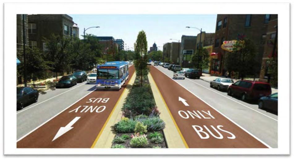
29 Figure 2-2: Build Alternative (Preferred Alternative) Page 14
30 Estimated Project Implementation Schedule To allow for flexible implementation and provide options for various funding opportunities, the Ashland Avenue BRT Project is proposed to be implemented in phases, as shown on Figure 2-3. Phase 1, from Cortland Street to 31 st Street, was identified to move forward first based on the following: Provides multiple transit network connections, including access to five CTA L stations, one Metra commuter rail station, and 16 bus routes Serves the IMD, a major regional employment hub providing over 20,000 jobs Serves other key activity generators, including industrial corridors, Malcolm X College and the United Center The existing bus service currently operates at some of the lowest bus speeds in the city Contains some of the highest ridership within the Ashland Avenue corridor Phase 2, from 31 st Street to 95 th Street in the south and from Cortland Street to Irving Park Road in the north (a total of 10.7 miles) would be implemented next, and would complete the 16.1-mile center running BRT service. Tables 2-2 and 2-3 provide an estimated project implementation schedule and key milestone dates identified and anticipated as this project moves forward (contingent upon funding availability): Table 2-2: Phase 1 Implementation Schedule (Cortland Street to 31 st Street) Timeframe Milestone February 2012 Project Initiation February 2013 February 2014 NEPA*/Concept Design March August 2015 Final Design February December 2016 Construction of Phase 1 January 2017 Begin Revenue Service in dedicated lanes within Phase 1 limits and as express service outside of these limits * National Environmental Policy Act of 1969 Table 2-3: Phase 2 Implementation Schedule (31 st Street to 95 th Street and Cortland Street to Irving Park Road) Timeframe Milestone October October 2017 Final Design February December 2018 Construction of Phase 2 January 2019 Operations Begin with BRT service in dedicated lanes along the entire 16.1-mile corridor. Future construction phase schedules are planned based on reasonable expectations and commensurate with funding availability. It should be noted that these dates are based on anticipated project activities, and are subject to modification based upon FTA review schedules, state and federal requirements and approvals for the project, and other factors that could occur through final design and construction of this project. Page 15
31 Figure 2-3: Ashland Avenue BRT Project Phasing Limits Page 16
32 Project Costs and Funding Construction costs were developed during the AA screening process and represent preliminary project costs of the Build Alternative. These estimates would be further refined through conceptual engineering. Anticipated capital costs for roadway improvements are on the order of approximately $161 million for the entire 16.1-mile corridor. Improvements for the 5.4-mile Phase 1 plan from Cortland Street to 31 st Street are estimated at $61 million for roadway construction. Vehicle costs are estimated at $50 million. Design costs are estimated at approximately 10 percent of roadway construction costs. Funding for these capital improvements would be sought for this project under FTA s Small Starts Program and supplemented by various local resources. Through each phase of implementation, detailed operating costs would be developed. Compared to local bus operational costs, CTA estimates that BRT service along Ashland Avenue would be 36 percent more cost efficient. Details on comparative costs may be found in the Screen 2 Technical Memorandum in Appendix A-3. Page 17
33 This page intentionally left blank Page 18
34 3. TRANSPORTATION CONDITIONS AND ANALYSIS This chapter provides detailed data on the potential transportation impacts of the 16.1-mile Build Alternative on the local and regional transportation system, including road traffic patterns, traffic volumes, parking, and transit facilities and services. Descriptions of existing conditions are included in each section for the purpose of examining the No-Build Alternative. Assumptions for determining impacts from the Build Alternative are provided for each area of the transportation analysis. The detailed supporting technical memoranda for each section are included in Appendix B through Appendix D, and are referenced as appropriate. This chapter will walk the reader through several steps to show: Traffic Analysis The first section will discuss the impacts to vehicles travelling in the corridor. This is measured utilizing both regional and local traffic models based on traffic counts from Parking Impact Analysis This section will identify the overall impacts to parking and loading zones in the corridor. Transit Operational Analysis The last section will discuss the impacts to transit operations in the corridor as a result of implementing the improved Bus Rapid Transit (BRT) service. 3.1 Traffic Analysis The Ashland Avenue BRT Project would cause changes in roadway traffic volumes, local access, and circulation patterns. This section further defines: Traffic related improvements proposed as part of this project, The methodology employed to assess potential traffic impacts, and Results of this analysis, and proposed recommendations. Mitigation efforts to offset potential impacts are described in Section 3.2. The Chicago Transit Authority (CTA) and the Chicago Department of Transportation (CDOT) have coordinated with the Federal Transit Administration (FTA), the Illinois Department of Transportation (IDOT), and Cook County Department of Transportation and Highways (CCDOTH) throughout the planning process on the traffic analysis. Additional traffic analysis is also part of this ongoing agency coordination process. As more traffic refinements are made through conceptual engineering and into final design and construction, CTA and CDOT would continue to work with agency partners and the public on more detailed design solutions to specific local traffic diversion along the corridor, including the provision of left turns at certain locations to provide additional residential and business access Defining the Proposed Action The Build Alternative proposes to implement BRT within the existing right-of-way and with minimal changes to the location of sidewalk curbs. Right-of-way is generally defined as the width between building faces and is useful for defining multimodal uses of the corridor such as sidewalk space for pedestrian use. Curb-to-curb widths refer to the area between the curbs that is utilized for moving vehicles (cars, trucks, buses, and bicycles) as well as for accommodating parking and loading zones. Right-of-way and curb-to-curb extents are shown on Figure 3-1. Page 19

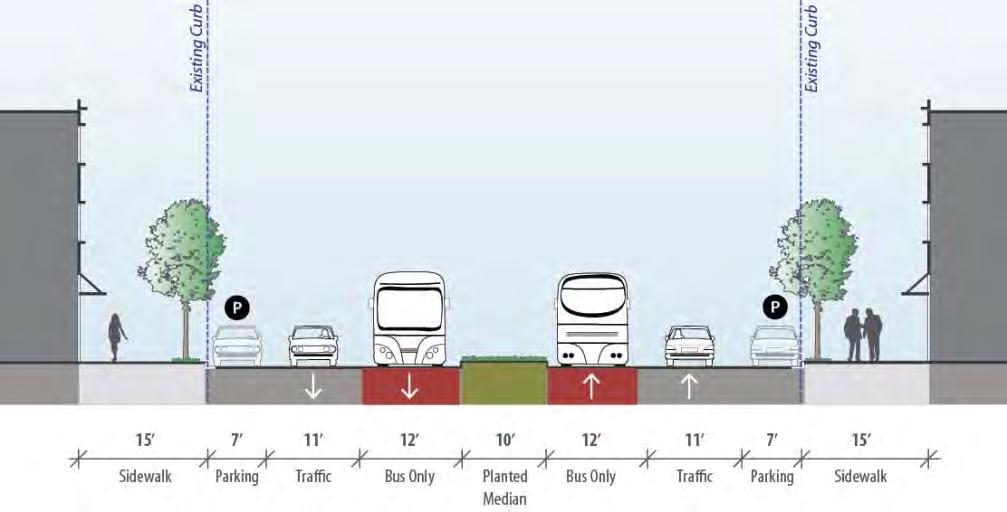
35 Figure 3-1: Right-of-Way and Street Width Extents One of the reasons BRT is a viable option for the Ashland Avenue corridor is that the existing right-of-way and curb-to curb widths can support an integrated, multimodal and connected network within the existing corridor. As shown in Table 3-1, existing right-of-way along the corridor varies between 100 and 110 feet, with curb-to-curb widths of 70 to 80 feet. Within the right-of-way, the space is dedicated to multiple transportation uses, as shown in Figure 3-2. These include: Sidewalks: Sidewalks exist along the length of Ashland Avenue. In some locations, planted grass strips between the sidewalk and curb provide a buffer between pedestrians and vehicular traffic. General Purpose Travel Lanes: Two northbound and two southbound travel lanes utilized by buses, automobiles, trucks, and bicycles. o Between Madison Street and Roosevelt Road, near the Illinois Medical District (IMD), curb-to-curb widths are wider (80 feet) and three existing lanes of traffic in each direction are provided without on-street parking. Intersections: Intersections are generally separated by raised or striped medians with right and left turning lanes at intersections. Medians: Northbound and southbound travel lanes are generally separated by raised or striped medians. Parking Lanes: Parking (metered and unmetered) is generally provided on both sides of the street. Page 20
36 Table 3-1: Existing Ashland Avenue Right-of-Way and Curb-to-Curb Widths Curb-to- Right-of- # of Lanes Distance Start Point End Point Curb Width Way Width Southbound Northbound (Mile) (Feet) (Feet) Irving Park Rd. Lake St Lake St. Madison St Madison St. Roosevelt Rd Roosevelt Rd. 15 th St th St. Cermak Rd Cermak Rd. Archer Ave Archer Ave. 95 th St Figure 3-2: Typical Existing Ashland Avenue Roadway Configuration The proposed Build Alternative, shown in Figure 3-3, would be implemented within the existing right-of-way. Figure 3-3: Typical Proposed Ashland Avenue Roadway Configuration Page 21
37 Within the right-of-way, the proposed Build Alternative includes: Sidewalks: Sidewalks would still exist along the length of Ashland Avenue. Additional pedestrian space, in the form of curb extensions, would be provided at signalized intersections. New curb ramps with truncated domes (a standard surface texture used to provide the visually impaired with detectable information about the boundary between the sidewalk and street), countdown pedestrian heads and audible pedestrian crossing devices to meet ADA accessibility requirements would be provided at all proposed station locations. These improvements, combined with installation of enhanced pedestrian amenities at each half mile station are proposed to improve pedestrian access and pedestrian travel throughout the corridor. BRT Lanes: One center running bus-only lane in each direction. One existing general purpose travel lane would be removed in each direction to accommodate the BRT lanes. General Purpose Travel Lanes: One general purpose travel lane would be maintained in each direction; two general purpose lanes would be maintained in each direction between Madison Street and Roosevelt Road. Left turn lanes and left turn pockets at intersections along the corridor are proposed to be removed and replaced by raised medians. As a result, left-turn movements from Ashland Avenue would be prohibited except at the following interstate highway access points in order to maintain regional traffic patterns: o Kennedy Expressway (I-90) via Armitage Avenue, o Eisenhower Expressway (I-290) via Van Buren Street and Congress Parkway, and o Stevenson Expressway (I-55) via 31 st Street and Robinson Street. At un-signalized intersections and alley ways, only right-turn movements onto and from Ashland Avenue would be allowed due to the presence of raised medians. Because a number of raised medians are already located along the corridor, existing access to properties and driveways along the corridor from opposite sides of the road are already restricted and are not anticipated to change greatly as a result of the proposed project. Transit Signal Priority (TSP): Upgrades would be installed at all signalized intersections along the corridor to manage traffic movements and provide efficient and reliable BRT movements. Medians: Northbound and southbound travel lanes would be separated by raised medians. The raised medians would extend the length of Ashland Avenue except at signalized intersections, key one-way streets, and at critical commercial drives that would be signalized. Parking: Parking would be predominantly retained on both sides of the street (see additional details on parking impacts in Section 3.3) Page 22
38 3.1.2 Traffic Impact Methodology For the purposes of understanding the traffic impacts of the Build Alternative, a detailed methodology has been developed to analyze impacts to roadway volumes, distribution and local circulation patterns. This process takes into account impacts from both a regional and localized perspective. It assumes full traffic implications of the Build Alternative including removal of one travel lane in each direction and left turns along the corridor (except at interstate access points). This methodology for the analysis provides a way to evaluate the greatest potential traffic impacts that could result from the Build Alternative. As more traffic refinements are made, CTA and CDOT would continue to work with agency partners and the public on more detailed design solutions to specific local traffic diversion along the corridor, including the provision of left turns at certain locations to provide sufficient residential and business access. 1. Regional Impacts Analysis: A regional traffic analysis of the Build Alternative was undertaken as a first step in this process. It quantifies changes in regional travel patterns resulting from removing a traffic lane in each direction and removal of left turns. Regional travel models are the standard analytical tool used for the analysis of travel patterns in urban areas. Chicago Metropolitan Agency for Planning (CMAP), the Chicago region s metropolitan planning organization (MPO), has developed and maintains a travel demand model for transportation planning within the Chicago metropolitan area, which was utilized for this regional analysis. The results of this analysis provide insight into the impact of the Build Alternative on the city-wide transportation network, including traffic impacts and benefits to transit ridership. In addition, the CMAP travel demand model was used to complete a more focused analysis of traffic diversion to roadways parallel and adjacent to the Ashland Avenue corridor. 2. Local Impacts Analysis: While regional travel demand analysis provides a basis for understanding the overall regional impacts and larger project area traffic impacts from traffic diverting to different roadways, these models are not designed to analyze specific, isolated corridor impacts such as intersection level capacity analysis. Data inputs from this regional model, however, do provide useful information for this more detailed analysis. A traffic analysis of intersection operating conditions along the corridor was also conducted using No-Build Alternative traffic data and modeled traffic volumes representing the Build Alternative design and operational conditions. This analysis identifies volume and capacity changes along the corridor itself as a result of the Build Alternative and provides a more detailed basis for special design considerations within the corridor and recommendations for local on- and off-corridor improvements. The following sub-sections provide more detailed information on these methods and results. Details on mitigation are provided in Section 3.2 to address the resulting impact analysis findings. Page 23
39 3.1.3 Regional Traffic Diversion Impacts Analysis City-Wide Diversion Evaluation With the removal of a travel lane in each direction, some vehicles currently using Ashland Avenue would divert or re-route to use other parallel roadways for their trips. For the regional transportation diversion analysis, the regional CMAP travel demand model was utilized. The CMAP travel demand model contains representation of the highway system (freeways, major arterials, and collectors) as well as the transit system (Metra commuter rail, CTA bus and rail service, and PACE bus service). Two key metrics analyzed by the CMAP model are Vehicle Miles Traveled (VMT) and Vehicle Hours Traveled (VHT). These are measures of the amount of driving that is taking place, cumulatively, in a given area or along a given corridor. VMT measures the number of miles driven; VHT measures the total time spent driving. The CMAP travel demand model also analyzed mode shifts that is, a measure of the shift of trips from using one mode of transportation (e.g. personal vehicles) to another mode (e.g. transit) anticipated from the Build Alternative. Further details on the CMAP model, input factors and further details on this regional diversion analysis can be found in Appendix B-1 (Regional Traffic Diversion Analysis Technical Memorandum). VMT = The number of miles driven. VHT = The total time spent driving. Mode Shift = Shift of trips from using one mode of transportation (e.g. personal vehicles) to another mode (e.g. transit) along a corridor. Initial CMAP modeling of the Build Alternative indicates that the proposed Ashland Avenue BRT service would result in very minor changes to daily city-wide traffic conditions. Compared to the existing conditions, people across the City of Chicago would be driving slightly shorter distances (VMT projected to decrease 0.08 percent), and for a slightly shorter amount of time (VHT projected to decrease 0.01 percent). The projected decreases in VMT and VHT indicate that the project would slightly decrease traffic volumes and/or shorten trips that would be diverted off of Ashland Avenue. Study Area Diversion Evaluation Given these minor city-wide changes, a smaller study area, surrounding the proposed Ashland Avenue BRT corridor was selected for more detailed traffic and transit analysis. The roadway network study area identified for more detailed diversion analysis was bounded by Irving Park Road, to the north, and 95 th Street, to the south. It included the major north-south roadways one mile to the east and two miles to the west of Ashland Avenue: (1) Kedzie Avenue, (2) California Avenue, (3) Western Avenue, (4) Damen Avenue, (5) Ashland Avenue, (6) Racine/Southport Avenue and (7) Halsted Street. See Figure 3-4 for the limits of the diversion analysis study area. These parallel roadways represent the most likely alternative roadways for diversion of traffic due to implementation of the Build Alternative. They were selected based on the CMAP travel demand model results and standard traffic engineering assumptions about travel behavior utilizing shortest paths between origins and destinations. Page 24

40 Figure 3-4: Diversion Analysis Study Area Page 25
41 In addition, the transit network including all existing north-south CTA bus routes operating on north-south roadways within the study area were defined as inputs for the transit impacts side of the analysis. Using the CMAP travel demand model and these inputs, an initial analysis was performed to determine impacts of implementing the Build Alternative on the roadways within the study area defined above. The analysis determined the congestion impacts on alternate routes as a result of the removal of two travel lanes on Ashland Avenue (reduction in roadway capacity). It also identified potential impacts outside of the corridor on other roadways due to re-routing of traffic off of Ashland Avenue. Details on the analysis procedure are provided in Appendix B-1. The following metrics were compared between existing conditions and the Build Alternative to determine the projected percent shift in traffic from Ashland Avenue to parallel arterials: VMT - summation of all VMT on roadway facility segments Congested VMT - summation of all VMT on roadway facility segments where the volume on the roadway exceeds the capacity of the roadway (v/c >1) Percent Congested VMT - congested VMT compared to total VMT VHT - summation of all VHT on roadway facility segments Congested VHT - summation of all VHT on roadway facility segments where the volume on the roadway exceeds the capacity of the roadway (v/c >1) Percent Congested VHT - congested VHT compared to total VHT Travel Speed - average congested travel speed (miles per hour [mph]) on roadway facility segments (both directions) VMT = The number of miles driven. VHT = The total time spent driving. Volume/Capacity (v/c) = Volume on the roadway compared to the capacity of the roadway. The existing conditions assumptions were based on the regional modeling inputs used for the 2010 analysis year in the air quality conformity analysis completed by CMAP in spring The roadway network represented the existing segment geometrics and capacity, left- and rightturn restrictions, and traffic signal timings. The transit network represented the existing bus route stop locations, frequency (number of buses per hour), service span (hours of operation), and bus speeds. The Build Alternative assumptions were based on the following design and operating assumptions and utilized maximum operational characteristics since full transit operational plans were not available at the time of the analysis: Left-Turn Restrictions left-turns were restricted at all the intersections along Ashland Avenue between Irving Park Road to the north, and 95 th Street to the south to determine the effects of maximum implementation of the BRT from a regional traffic standpoint. Travel Lane Removal one travel lane in each direction was removed along Ashland Avenue between Irving Park Road, to the north, and 95 th Street, to the south. BRT Service Characteristics BRT service characteristics assumed a 24 hour service span, 5 minute headways, 15.9 miles per hour average running speed, and proposed stop locations at the 35 proposed intersections along the corridor. Local bus service is assumed to remain in place. Page 26
42 These assumptions provide the most rigorous implementation of project design and operational features of BRT in order to ascertain traffic diversion impacts. More detailed results of travel volumes for existing (No-Build) and the Build Alternative by route and in aggregating north-south and east-west movements are provided in Appendix B-1. A comparison of the change in traffic volumes resulting from the Build Alternative is also provided in Appendix B-1. Tables 3-2 and 3-3 summarize the results of that analysis. Compared to existing conditions, the Build Alternative conditions decreased the total miles driven on Ashland Avenue (VMT projected to decrease by 35 percent) and increased the number of those miles driven during congested conditions (congested VMT projected to increase by seven percent). Similarly, the total hours driven decreased (VHT projected to decrease by 34 percent) and the total time drivers spend in congested conditions increased (congested VHT projected to increase by seven percent), resulting in a net ten percent decrease in average daily travel speed along Ashland Avenue. Compared to existing conditions, the Build Alternative conditions decreased VMT by one percent and increased congested VMT by five percent within the study area. VHT would not change as a result of the Build Alternative and congested VHT would increase by six percent. The Build Alternative would result in a traffic shift from Ashland Avenue to other roadways in the surrounding roadway network. However, the results of the analysis indicate that the robust Chicago grid network is sufficient to absorb the traffic shifts across multiple parallel roadways, resulting in minor VMT increases (two percent to 12 percent) along any one facility within the study area. The grid network provides many different traffic routing options for drivers between origins and destinations within the city. Table 3-2: Percent Change between Existing Conditions and Build Conditions by Routes Racine Ave./ Kedzie California Western Damen Ashland Southport Halsted Ave. Ave. Ave. Ave. Ave. Ave. St. (and adjacent routes) VMT 3% 2% 6% 2% -35% 12% 4% Congested VMT 4% 8% 29% 4% 7% 25% 4% VHT 3% 2% 7% 5% -34% 12% 5% Congested VHT Travel Speed Source: CMAP, May % 6% 30% 8% 7% 24% 6% -1% -1% -2% -3% -10% -3% -1% Page 27
43 Table 3-3: Percent Change between Existing Conditions and Build Conditions by Corridors North South Corridor East West Corridor North-South & East-West Corridors VMT -2% 0% -1% Congested VMT 10% 0% 5% VHT -1% 0% 0% Congested VHT 11% 1% 6% Source: CMAP, May Appendix B-1 also includes maps showing the breakdown of traffic diverted from Ashland Avenue to parallel roadways for AM and PM peak hours within the Phase 1 limits Local Impacts Analysis: Corridor Intersection Level Capacity Analysis In order to evaluate the local impacts, a traffic analysis of intersection operating conditions was conducted. The purpose of this analysis was to identify specific locations that present critical impediments to traffic flow and to provide design considerations for the Build Alternative at these locations. This analysis was conducted for (1) Existing Conditions and (2) Build Alternative conditions. Traffic volumes, roadway design (i.e., lane widths, number of lanes), and traffic signal timing plans were some of the inputs used to analyze Level of Service (LOS) at all signalized intersections along Ashland Avenue. In addition, a field review was conducted to evaluate intersection operations and traffic flows during AM and PM peak (rush hour) travel periods. Detailed information on the traffic analysis methodology, inputs, and outputs are provided in Appendix B-2. The methodology used for the development of this intersection capacity analysis included: 1) 2013 traffic count data supplemented by adjusted historic traffic data from CDOT for 89 signalized intersections 2) Existing AM and PM peak hour traffic conditions were analyzed using SYNCHRO modeling software 3) Traffic volume forecasts for the Build Alternative conditions were developed based on the CMAP regional travel demand model for existing conditions and assuming design considerations of the Build Alternative 4) Build Alternative AM and PM peak hour traffic conditions were analyzed using SYNCHRO modeling software 5) Intersection operating deficiencies resulting from implementation of the project were identified and special design considerations at these locations are provided Page 28

44 The SYNCHRO traffic analysis determined the LOS for the intersections along the corridor. LOS provides a representative letter scale from LOS A to LOS F, with LOS A representing uncongested or free flow conditions and LOS F representing significantly congested conditions, as shown in Table 3-4. Table 3-4: Categorization of Level of Service Signalized Intersection Level of Service LOS A = LOS B = LOS C = LOS D = LOS E = LOS F = Free flow (intersection control delay: <10 sec/veh) Reasonably free flow (intersection control delay: sec/veh) Stable flow (intersection control delay: sec/veh) Approaching unstable flow (intersection control delay: sec/veh) Unstable flow (intersection control delay: sec/veh) Forced or breakdown flow (intersection control delay: > 80 sec/veh) Source: Transportation Research Board, Highway Capacity Manual 2010, National Research Council, As shown in the summary intersection LOS table in Appendix B-2 and graphically on Figures 3-5 to 3-8, the majority of the intersections along Ashland Avenue are currently operating at an acceptable LOS (LOS D or better) in both AM and PM peak hours. However, six intersections of the 89 are currently operating at LOS E or worse in either or both the AM or PM peak hours or in both AM and PM peak hours. These six intersections with existing deficiencies would continue to operate at unacceptable LOS with the Build Alternative and intersection delay (average total delay of vehicles at all intersection approaches) is expected to increase at these locations, as shown in Table 3-5. CDOT considers LOS A through D acceptable. CDOT considers LOS E and F unacceptable. Table 3-5: Ashland Avenue Existing Deficient Intersection LOS and Intersection Delay (in seconds) Intersection Existing Build Change AM PM AM PM AM PM Belmont Avenue/Lincoln Avenue F/128.2 F/84.8 F/162.7 F/ Diversey Parkway F/131.7 F/115.6 F/225.1 F/ Clybourn Avenue E/74.9 E/73.5 E/60.7 D/ Van Buren Street F/94.4 B/18.7 E/59.7 C/ Roosevelt Road E/59.7 D/50.3 D/46.6 E/ Cermak Road/Blue Island Avenue E/68.1 D/51.5 F/145.6 F/ Page 29
45 Seven intersections of the 89 are currently operating at LOS D or better in both the AM and PM peak hours under existing conditions but would operate at unacceptable LOS either in the AM, PM, or both AM and PM peak hours under the Build Alternative. Intersection delay is expected to change, as shown in Table 3-6. Mitigation options for these intersections are discussed in the section that follows. Table 3-6: Ashland Avenue Unacceptable LOS and Delay (in seconds) Intersection Existing Build Change AM PM AM PM AM PM Irving Park Road D/46.2 D/38.7 F/64.9 F/ Addison Street D/51.0 C/25.4 E/66.0 D/ Webster Avenue C/21.3 C/23.2 C/30.5 E/ Armitage Avenue D/41.3 D/37.9 D/40.1 E/ Cortland Street B/18.4 C/20.4 E/61.5 E/ North Avenue D/40.9 D/39.2 D/42.0 E/ Augusta Boulevard B/17.8 C/20.6 C/33.6 F/ Page 30
46 Figure 3-5: Existing and Build Conditions AM Peak Hour Level of Service (1 of 2) Page 31
 Page")
47 Figure 3-6: Existing and Build Conditions AM Peak Hour Level of Service (2 of 2) Page 32
 Page")
48 Figure 3-7: Existing and Build Conditions PM Peak Hour Level of Service (1 of 2) Page 33
49 Figure 3-8: Existing and Build Conditions PM Peak Hour Level of Service (2 of 2) Page 34
50 3.2 Traffic Mitigation Based on the results of the local and regional impact analysis (Section 3.1), potential mitigation measures are identified and discussed in detail in the following section. Implementation of these mitigation measures would result in traffic impacts for this project which would be less than significant. This section includes: Overview of Local Impacts and Proposed Mitigation Potential Mitigation Measure Options Potential Mitigation within Existing Curb-to-Curb Width Potential Mitigation outside Existing Curb-to-Curb Width Local Traffic Diversion Impacts and Proposed Mitigation Overview of Local Impacts and Proposed Mitigation As discussed (in Section 3.1.4), 13 of the 89 signalized intersections along the corridor would operate at unacceptable LOS either in the AM, PM or both AM and PM peak hours with implementation of the Build Alternative. This includes the following: 6 of 89 intersections with existing deficiencies would continue to operate at unacceptable LOS with the Build Alternative 7 of 89 intersections are currently operating at LOS D or better in both the AM and PM peak hours under existing conditions but would operate at unacceptable LOS either in the AM, PM or both AM and PM peak hours with implementation of the Build Alternative. Potential mitigation measures to reduce or minimize the LOS impacts were evaluated for these intersections along Ashland Avenue. Implementation of these potential mitigation measures would bring all unacceptable intersection LOS under the Build Alternative up to acceptable operating conditions (LOS D or better). Table 3-7 identifies the results comparing existing conditions and mitigated Build Alternative conditions. This shows that mitigation would result in acceptable LOS at these intersections Potential Mitigation Measure Options As described in Section 2.3, the Build Alternative is proposed to be implemented within the existing right-of-way. In addition, the project aims to implement the proposed BRT project improvements and any mitigation without adjusting the sidewalk curbs in order to retain existing sidewalk widths and be consistent with CDOT s Complete Streets Chicago Design Guidelines 7. These guidelines established design parameters for all modes of transportation and primarily emphasize walking, bicycling, and public transit. 7 Chicago Department of Transportation, Complete Streets Chicago Design Guidelines, Page 35
51 Table 3-7: Ashland Avenue Intersection LOS and Delay (in seconds) with Mitigation Build with Existing Change Intersection Mitigation AM PM AM PM AM PM Belmont Avenue/ Lincoln Avenue F/128.2 F/84.8 D/48.0 D/ Diversey Parkway F/131.7 F/115.6 D/36.5 C/ Clybourn Avenue E/74.9 E/73.5 D/48.7 D/ Van Buren Street F/94.4 B/18.7 D/51.1 D/ Roosevelt Road E/59.7 D/50.3 D/44.1 D/ Cermak Road/ Blue Island Avenue E/68.1 D/51.5 D/50.1 D/ Irving Park Road D/46.2 D/38.7 D/53.9 D/ Addison Street D/51.0 C/25.4 D/41.4 C/ Webster Avenue C/21.3 C/23.2 C/23.0 D/ Armitage Avenue D/41.3 D/37.9 C/33.7 D/ Cortland Street B/18.4 C/20.4 C/31.6 C/ North Avenue D/40.9 D/39.2 C/32.4 D/ Augusta Boulevard B/17.8 C/20.6 C/26.5 D/ Note: Mitigation measures that require increasing the curb-to-curb width at intersections are shown in bold. For the 13 intersections listed in Table 3-7, potential mitigation measures within the existing curb-to-curb width were evaluated to achieve an acceptable LOS. The mitigation measures include modifying existing lane configurations, adding or extending left- and right-turn lanes to create more storage space for turning vehicles, and adjusting the traffic signal timing schemes to provide better traffic progression. It would be possible to implement these mitigation measures within the existing roadway width for six of the 13 intersections. At the remaining seven intersections it would not be possible to implement mitigation measures within the existing curb-to-curb width and achieve an acceptable LOS. For these intersections, widening the roadway width to implement mitigation measures was also evaluated. While these physical improvements would result in an acceptable LOS at these intersections, they would require reductions to sidewalk and median widths. These mitigation efforts would be inconsistent with CDOT s Complete Streets Chicago Design Guidelines and additional coordination with agencies and stakeholders would be needed prior to implementation of these options. Page 36
52 3.2.3 Potential Mitigation within Existing Curb-to-Curb Width Potential mitigation measures that could be accommodated within the existing curb-to-curb widths and which would retain existing sidewalk widths were tested first for the intersections with unacceptable LOS. Mitigation measures would only be possible to implement within the existing curb-to-curb widths for six of the 13 intersections. These potential mitigation measures are described in detail below for these six intersections. Clybourn Avenue Potential mitigation measures to bring this intersection up to acceptable LOS during both AM and PM peak hours include removing parking on Clybourn Avenue to accommodate an additional eastbound through lane on Clybourn Avenue. This intersection currently operates at an unacceptable LOS E during AM and PM peak hours. With implementation of the Build Alternative, LOS during AM peak hours would continue to operate at unacceptable LOS E and operations during PM peak hours would be slightly improved to acceptable LOS D. With implementation of these mitigation measures, this intersection would operate at LOS D during AM and PM peak hours. Van Buren Street Potential mitigation measures to bring this intersection up to acceptable LOS for both AM and PM peak hours include modifying the existing westbound through lane to a westbound left-turn lane for dual left-turn lanes on Van Buren Street and modifying the inside northbound through lane to a shared through/leftturn lane on Ashland Avenue. This intersection currently operates at an unacceptable LOS F during AM peak hours and LOS B during PM peak hours. With implementation of the Build Alternative, this intersection would continue to operate at unacceptable LOS E during AM peak hours and continue to operate at acceptable LOS C during PM peak hours. With implementation of these mitigation measures, this intersection would operate at LOS D during AM and PM peak hours. Roosevelt Road Potential mitigation measures to bring this intersection up to acceptable LOS during both AM and PM peak hours include adding an eastbound through lane on Roosevelt Road and adjusting parking and bike lanes on Roosevelt Road to allow diverging and merging zones for general traffic. This intersection currently operates at unacceptable LOS E during AM peak hours and acceptable LOS D during PM peak hours. With implementation of the Build Alternative, this intersection would operate at acceptable LOS D during AM peak hours and unacceptable LOS E during PM peak hours. With implementation of these mitigation measures, this intersection would operate at LOS D during AM and PM peak hours. Addison Street Potential mitigation measures to bring this intersection up to acceptable LOS during both AM and PM peak hours include removing parking on Addison Street to accommodate eastbound and westbound through lanes on Addison Street. Page 37
53 The Addison Street and Ashland Avenue intersection currently operates at acceptable LOS D during AM peak hour and LOS C during PM peak hour. With implementation of the Build Alternative, this intersection would operate at unacceptable LOS E during AM peak hours and acceptable LOS D during PM peak hours. With implementation of these mitigation measures, this intersection would operate at LOS D during AM peak and LOS C during PM peak hours. Webster Avenue Potential mitigation measures to bring this intersection up to acceptable LOS during both AM and PM peak hours include adding northbound and southbound right-turn lanes on Ashland Avenue. This intersection currently operates at acceptable LOS C during both AM and PM peak hours. With implementation of the Build Alternative, this intersection would operate at acceptable LOS C during AM peak hours and unacceptable LOS E during PM peak hours. With implementation of these mitigation measures, this intersection would operate at LOS C during AM peak and LOS D during PM peak hours. Augusta Boulevard Potential mitigation measures to bring this intersection up to acceptable LOS during both AM and PM peak hours include adding northbound and southbound right-turn lanes on Ashland Avenue at Augusta Boulevard. This intersection currently operates at acceptable LOS B during the AM peak period and LOS C during the PM peak hour. With implementation of the Build Alternative, this intersection would continue to operate at acceptable LOS C during AM peak hours and unacceptable LOS F during PM peak hours. With implementation of these mitigation measures, this intersection would operate at LOS C during AM peak and LOS D during PM peak hours. Implementation of these mitigation measures within the existing roadway width would bring six of the 13 intersections, which would operate at unacceptable LOS under the Build Alternative, to acceptable LOS standards. Figures 3-9 through 3-12 show the LOS for Existing and Build Alternative with these mitigation measures included. Concept plans depicting the potential mitigation for these intersections are included in Appendix B-3. Page 38
54 Figure 3-9: Existing and Mitigated (inside curb-to-curb) Build Conditions AM Peak Hour Level of Service (1 of 2) Page 39
55 Figure 3-10: Existing and Mitigated (inside curb-to-curb) Build Conditions AM Peak Hour Level of Service (2 of 2) Page 40
56 Figure 3-11: Existing and Mitigated (inside curb-to-curb) Build Conditions PM Peak Hour Level of Service (1 of 2) Page 41
57 Figure 3-12: Existing and Mitigated (inside curb-to-curb) Build Conditions PM Peak Hour Level of Service (2 of 2) Page 42
58 3.2.4 Potential Mitigation outside Existing Curb-to-Curb Width At seven intersections mitigation is not possible within the existing curb-to-curb width. For these locations, potential mitigation measures outside of the existing curb-to-curb width were also tested. While these physical improvements provide the ability to improve LOS at these intersections, they would require reductions to sidewalk and median widths in order to provide an additional through or turn lane. These mitigation efforts would be inconsistent with CDOT s Complete Streets Chicago Design Guidelines and additional coordination would be needed prior to implementation of these measures. These potential mitigation efforts are described in detail below for the seven intersections. Belmont Avenue/Lincoln Avenue Potential mitigation measures outside of the existing curb-to-curb width to bring this intersection up to acceptable LOS during both AM and PM peak hours would include removing parking on Belmont Avenue to accommodate additional eastbound and westbound through lanes on Belmont Avenue, and adding southeast bound and northwest bound through/right-turn lanes on Lincoln Avenue. This intersection currently operates at an unacceptable LOS F during AM and PM peak hours. With implementation of the Build Alternative, this intersection would continue to operate at unacceptable LOS F during AM and PM peak hours. With implementation of these mitigation measures, this intersection would operate at LOS D during AM and PM peak hours. Diversey Parkway Potential mitigation measures outside of the existing curb-to-curb width would include removing parking on Diversey Parkway to accommodate adding eastbound and westbound through lanes on Diversey Parkway and adding northbound and southbound through lanes on Ashland Avenue. This intersection currently operates at an unacceptable LOS F during AM and PM peak hours. With implementation of the Build Alternative, this intersection would continue to operate at unacceptable LOS F during AM and PM peak hours. With implementation of these mitigation measures, this intersection would operate at LOS D during AM peak and LOS C during PM peak hours. Cermak Road/Blue Island Avenue Potential mitigation outside of the existing curb-tocurb width would include installing an additional northeast bound through lane on Blue Island Avenue and adding northbound and southbound through lanes by converting existing right-turn lanes into shared through/right-turn lanes on Ashland Avenue. This intersection currently operates at unacceptable LOS E during AM peak hours and acceptable LOS D during PM peak hours. With implementation of the Build Alternative, this intersection would continue to operate at unacceptable LOS F during AM and PM peak hours. With implementation of these mitigation measures, this intersection would operate at LOS D during AM and PM peak hours. Page 43
59 Irving Park Road Potential mitigation outside of the existing curb-to-curb width would include adding a westbound through lane on Irving Park Road and a southbound through lane on Ashland Avenue. This intersection currently operates at acceptable LOS D during both AM and PM peak hours. With implementation of the Build Alternative, this intersection would operate at unacceptable LOS F during both AM and PM peak hours. With implementation of these mitigation measures, this intersection would operate at LOS D during AM and PM peak hours. Armitage Avenue Potential mitigation outside of the existing curb-to-curb width would include adding an additional eastbound left-turn lane and widening under the railroad bridge over the west leg on Armitage Avenue. This intersection currently operates at acceptable LOS D during both AM and PM peak hours. With implementation of the Build Alternative, this intersection would continue to operate at LOS D during AM peak hours and at unacceptable LOS E during PM peak hours. With implementation of these mitigation measures, this intersection would operate at LOS C during AM peak and LOS D during PM peak hours. Cortland Street Potential mitigation outside of the existing curb-to-curb width would include adding northbound and southbound turn lanes, widening under the railroad bridge over the north leg of Ashland Avenue, and widening under the railroad bridge over the east leg of Cortland Street. This intersection currently operates at acceptable LOS during both AM (LOS B) and PM (LOS C) peak hours. With implementation of the Build Alternative, this intersection would operate at LOS E during AM and PM peak hours. With implementation of these mitigation measures, this intersection would operate at LOS C during AM and PM peak hours. North Avenue Potential mitigation outside of the existing curb-to-curb width would include adding eastbound and westbound through lanes (one in each direction) on North Avenue. This intersection currently operates at acceptable LOS D during both AM and PM peak hours. With implementation of the Build Alternative, this intersection would continue to operate at LOS D during AM peak hours and LOS E during PM peak hours. With implementation of these mitigation measures, this intersection would operate at LOS C during AM peak and LOS D during PM peak hours. In summary, under mitigated Build Alternative conditions that could be accommodated within the existing curb-to-curb widths, six of the 13 intersections would operate at LOS D or better in both the AM and PM peak hours, while seven intersections would operate at LOS E or F in either the AM or PM peak hours or both AM and PM peak hours. Under mitigated Build Alternative conditions including increasing the existing curb-to-curb widths, all of the thirteen intersections would operate at LOS D or better in both the AM and PM peak hours. Page 44
60 CTA and CDOT would continue to work through final design on mitigation options for these thirteen intersections. For improvements identified within the existing curb-to-curb widths, CTA and CDOT would continue to coordinate with CCDOTH and IDOT through final design on implementation of these mitigation options. Recognizing that mitigation measures outside of the existing curb-to-curb would be inconsistent with CDOT s Complete Streets Chicago Design Guidelines, these mitigation measures would need to be further coordinated with CDOT and go through additional public outreach processes before implementation Local Traffic Diversion Impacts and Proposed Mitigation Based on the diversion analysis detailed in Section 3.1.3, two levels of diversion mitigation are proposed to address potential impacts of the Build Alternative: (1) potential mitigation related to parallel roadways which represent the most likely alternative roadways for diversion of traffic and (2) potential mitigation measures related to neighborhood level impacts of traffic diversion. Implementation of these proposed mitigation measures would result in diversion impacts which would be less than significant. While the diversion analysis conducted indicates that no one parallel roadway would absorb the majority of diverted traffic, operational improvements are proposed to minimize impacts of potential increases in traffic demand on major parallel roadways (as identified in Table 3-2). The mitigation measures on these parallel roadways would include the following: (a) upgrading traffic signal equipment, (b) coordinating traffic signal timing and traffic progression plans, or (c) providing additional turn lanes. Another option that would be considered involves providing additional transit, bicycle, or pedestrian accommodations along these roadways. The specific locations for these mitigation measures would be determined in final design. CTA and CDOT are committed to developing block-by-block, location-specific diversion mitigation plans in coordination with IDOT and other stakeholders through final design and construction. Once location-specific parallel roadway mitigation plans are finalized, additional analysis would also review the localized impacts of removing left turn lanes from Ashland Avenue. Improvements would be developed and recommended to target specific neighborhood-level impacts while minimizing changes to the existing transportation network. CTA and CDOT would continue to work with the local community through final design and implementation to ensure that both diversion impacts on major arterials and on neighborhood streets are mitigated. In the case where diversion occurs outside of the modeled results, mitigation measures would be utilized to address potential neighborhood-level traffic diversion impacts and local traffic calming needs (that may arise subsequent to implementation). These mitigation measures would include: geometric changes, signal installation, access changes, and traffic calming measures that is, measures added to local roadways that are designed to reduce speeds or traffic levels. Page 45
61 The following represent the most likely traffic calming measures that would be implemented in the study area. These measures are identified in CDOT s Tools for Safer Streets 8 and have been proven to lessen the impact of additional vehicular traffic and make intersections, corridors, and neighborhood streets safer for pedestrians. Many of the traffic calming measures described below already exist along roadways within the diversion analysis study area and have been successful at providing neighborhood-specific mitigation measures to traffic impacts. These include: Marked crosswalks Indicate where pedestrians may cross the street and where drivers should expect them to cross. In-road state law Stop for Pedestrians signs State and City law require that vehicles must stop for pedestrians who are in a crosswalk and in-road signs remind drivers of this law. Pedestrian refuge islands Protected area that allows pedestrians to cross one direction of traffic at a time. Accessible pedestrian signals Provides auditory and/or vibrotactile information to pedestrians that are blind. Pedestrian countdown timers Provide information on the amount of time remaining to cross the street at signalized intersections. Speed feedback signs Display passing vehicle speeds and have been shown to increase driver compliance with the speed limit. Vertical traffic calming Speed bumps, speed humps, and speed tables are devices that are placed in the middle of the road and require vehicles to slow down to cross over them. Bump-outs Extend the sidewalk into a parking or non-moving lane, which reduce vehicle turning speeds and pedestrian crossing distance. Neighborhood traffic circles Circular islands used to reduce vehicular speeds through the intersection. 8 City of Chicago Department of Transportation, Tools for Safer Streets. Page 46
62 In addition, CDOT s Tools for Safer Streets provides other traffic calming measures which have been implemented in Chicago and may also be considered as part of final design plans. These include: Signals and beacons Traffic signals provide a protected crossing and inform pedestrians when to cross the street. Pedestrian hybrid beacons stop traffic to allow pedestrians to cross. Rectangular rapid flash beacons can be used as a warning device at uncontrolled or midblock crossings. Leading pedestrian intervals Gives pedestrians a head start into an intersection before vehicles. Lagging left turns Allows pedestrians to cross the intersection at the beginning of a traffic signal cycle, reducing the conflicts with left-turning vehicles. Road diets Reduces the amount of space for motor vehicles, either through eliminating lanes or shrinking the width of lanes. The reclaimed space from a road diet is then reallocated for other uses, such as turn lanes, pedestrian refuge islands, bike lanes, or more sidewalk space. Roundabouts Circular intersections where vehicles travel in a counter-clockwise direction and entering vehicles must slow down and yield to circulating vehicles. Chicanes Create extra turns in a road by installing a series of midblock bump-outs on alternating sides of the streets that require vehicles to slow down to maneuver through them. Skinny streets Convert one-way streets that are wider than 30 feet to two-way streets with narrow travel lanes that reduce vehicle speeds. As noted, the above lists include potential traffic calming measures identified in CDOT s Tools for Safer Streets 8. CTA and CDOT would continue to coordinate with other agencies and work with the local community before implementing any of these mitigation options. 3.3 Parking Impact Analysis In order to accommodate center running bus-only lanes within the existing right-of-way, one of the design features for the Ashland Avenue BRT Project would include removal of on-street parking near station locations along the corridor. Detailed design solutions for station intersections, including the provision of left turns at certain locations to provide sufficient residential and business access, would be determined through conceptual engineering and into final design in coordination with agency partners and the public involvement process. The results of this process would define the exact number of parking spaces at each location. As such, the detailed parking impact analysis conducted for this (EA) takes into account conceptual engineering to identify the parking impacts that would likely occur from implementation of the Build Alternative. Page 47
63 This section details the existing parking inventory along the corridor and the results of a parking demand analysis that was undertaken as part of the planning for this project. A discussion of the parking impacts and ways to avoid, minimize, or mitigate impacts to nearby residential or business communities is also provided for the purposes of this EA. CTA would continue to work with the public and the City of Chicago through final design and construction to coordinate and address impacts resulting from the removal of on-street parking along portions of the Ashland Avenue corridor Changes to Parking Supply Parking represents the total on-street parking spaces, on both sides of the street, including loading zones, metered parking spaces, and unmetered parking spaces, within the corridor. Parking space impact estimates were developed based on the conceptual roadway alignment and station layout design for the Build Alternative. There are approximately 3,410 parking spaces along the corridor. The majority (approximately 83 percent) of these spaces are located at unpaid or unmetered parking spaces. In many of these locations along the corridor, parking stalls are not marked. The Build Alternative would remove between approximately 11 to 12 percent of total on-street parking along the corridor, retaining between 88 to 89 percent of total parking. The Institute for Transportation and Development Policy (ITDP) conducted an assessment in June 2012 of existing parking within the project area to identify whether adjacent cross street parking was available to offset any changes to parking within the corridor. The full report of this analysis is included in Appendix C. Since the analysis was initially conducted, the total parking supply has been refined through field visits and additional review of aerial photographs. However, the results of the ITDP evaluation provide the necessary information to assess whether comparable parking exists to address parking losses. The results of this analysis indicate the presence of underutilized on-street and off-street parking owned and operated by various parties at cross streets which would provide suitable parking alternatives. Adequate comparable parking is not available at cross streets at two discrete locations along the project corridor from Thomas Street to Erie Street, and from 47 th Street to 50 th Street. No stations are proposed at Thomas Street or Erie Street, and all existing parking would be retained along this section of Ashland Avenue. The 47 th Street station is proposed between 47 th and 50 th Street. In this section, parking would be retained along Ashland Avenue, except in close proximity to the proposed station location at 47 th Street. An estimated 23 unmetered parking spaces (total for both sides of the roadway) may be removed for implementation of the Build Alternative; existing on-street parking would continue to be available near this location, and residents and businesses near this proposed station location would benefit from enhanced access to the area through the BRT service Parking Demand Analysis Parking supply only represents one factor needed to understand parking impacts. A parking demand analysis was completed in August 2012 to build on the parking inventory data gathered and to identify maximum and average parking use in different sections of the corridor. To conduct this analysis, field teams were deployed over an eight-day period in July 2012 to survey average and maximum parking. For representative coverage, field surveys were conducted for Monday through Thursday as well as on Saturday and Sunday of the same week. Page 48
64 Surveyors recorded the presence of parked vehicles on each block throughout the corridor and measured six temporal data sets: Early AM peak (6 AM 7 AM) AM peak (7 AM 9 AM) Midday (9 AM 4 PM) PM peak (4 PM 6 PM) Evening (6 PM 9 PM) Weekend (All Saturday and Sunday) Summary results of this analysis are shown in Table 3-8, which includes percent use based on the current parking space estimate of 3,410. Previously, a 2012 study by ITDP estimated the number of available parking spaces as 3,676. As described in Section 3.3.1, subsequent to the ITDP report, the parking space estimate was refined to 3,410. Additional details on analysis findings by ward are included in Appendix C. Based on the parking demand analysis, the average observed parking use was highest for the midday and Saturday service periods. Maximum use was higher than average use, although roughly one-third of the total parking capacity was observed as unused along the corridor. Given these factors, the minimal total parking anticipated to be converted for implementation of the Build Alternative were not deemed to be of significant impact to residents or businesses. Residents and businesses would benefit from increased access through premium BRT service along the corridor with enhanced pedestrian access to these areas. Table 3-8: Ashland Avenue Average Parking Demand Average Parking % Use Early AM Peak* 6 AM 7 AM 22% AM Peak 7 AM 9 AM 27% Midday 9 AM 4 PM 40% PM Peak 4 PM 6 PM 35% Evening 6 PM 9 PM 34% Saturday 41% Sunday 36% Maximum Use of Parking % Use Weekday 73% Saturday 55% Sunday 54% *Counts were not completed for the entire corridor. Page 49
65 3.3.2 Summary of Parking Impacts Initial estimates for the Build Alternative assume retaining approximately 89 percent of parking along the corridor. Implementation of the intersection mitigation measures detailed in Section would require the removal of additional parking spaces. The result of these mitigation measures would result in approximately 88 percent of the parking retained along the corridor. Given the analysis of parking supply and demand and the availability of comparable parking along adjacent streets throughout the majority of the corridor, no specific parking mitigation is proposed at this time. Minimal impacts are anticipated to occur to paid parking or loading zone parking, and through much of the Ashland Avenue corridor, parking stalls are not clearly marked or currently fully utilized. In addition, parking demand analysis conducted indicates that roughly one-third of the total parking capacity was observed as unused along the corridor. CTA and CDOT would continue to work with the public through final design and construction as localized concerns are determined and addressed. Comparable parking would continue to be available at cross streets near BRT stations to serve residents and businesses. Outside of station areas, on-street parking would be retained and no loading zones would be impacted. Any additional changes to parking would be based on local decision-making regarding preferred access and local traffic concerns. These decisions would be identified and coordinated through the public involvement process and with the City of Chicago (DHED) as part of stakeholder outreach efforts in final design. 3.4 Transit Operational Analysis The proposed Ashland Avenue BRT Project would bring a new, premium mode of transit service to CTA s highest bus ridership route along Ashland Avenue from Irving Park Road in the north to 95 th Street in the south (16.1 miles). The first phase (Phase 1) of design and construction would be located between Cortland Street in the north and 31 st Street in the south (5.4 miles). While construction of BRT median stations, center running bus-only lanes and TSP upgrades would first be constructed in this area, limited stop service would be provided throughout the entire 16.1-mile corridor at the proposed BRT station locations using existing curbside bus stops until Phase 2 is constructed. The BRT vehicles would include doors on both sides of the vehicle in order to serve (1) the median stations and (2) existing curbside bus stops until Phase 2 is constructed. Conceptual plans for the Build Alternative, indicating the layout for both Phase 1 and Phase 2 are included in Appendix G. Corridor design in Phase 2 would be similar to that in Phase 1 and would include center running, dedicated BRT lanes and center median stations. Details on the proposed phasing plan are provided in Section 2.3. A trademark of BRT is increased frequency and capacity of service compared to regular bus service. The Ashland Avenue BRT Project is anticipated to operate at between five and 15 minute headways in peak and off-peak hours. The BRT service would operate from 4:00 a.m. to 1:00 a.m., a span of service of 21 hours per day. CTA estimates that the total number of buses required to operate BRT peak and off-peak service with the proposed headways would be 12 vehicles (peak) and four vehicles (off-peak) in each direction for the 16.1-mile corridor. Existing local CTA Bus Route #9 bus service would continue to operate in a similar manner as today when Phase 1 is implemented. Due to expected ridership shifts from Route #9 to the faster and more reliable BRT service, Route #9 frequency may be adjusted once the BRT service has matured. CTA is committed to maintaining Route #9 to provide local bus service as a complement to the BRT service. This configuration of service provides benefits to customers Page 50
66 making both local and express transit trips. There are 35 proposed BRT station locations that would be implemented approximately every half mile and at CTA rail stations to provide faster and more reliable service in the corridor, with fewer stops than the existing bus service. As mentioned above, the Route #9 service would continue to operate as it does currently, stopping at every bus stop (approximately every oneeighth of a mile) along the corridor. Under the Build Alternative, improvements to pedestrian crossings and enhanced access to adjacent transit facilities would be provided at station locations, with increased amenities at BRT stations compared to local bus stops. These improvements to the pedestrian environment are proposed along with complete streets design considerations (i.e., designs that consider all users of the roadway), such as special sidewalk and curb design, to create an integrated and holistic transportation network in the corridor that not only accommodates all modes, but which would accommodate all users of the transit service and pedestrian environment. CTA and CDOT have both established complete streets design guidelines that would be incorporated into final design. CDOT s Complete Streets Chicago Design Guidelines 9 and CTA s Transit Friendly Design Guide 10 would be used to ensure that the design of stations and crossings fit the form and function of adjacent land uses and roadway typologies within the corridor. Potential benefits to the transit system as a result of the Build Alternative which are discussed within the context of this EA include: 1. Travel Time and Reliability Changes 2. Changes to Transit Patronage and Demand 3. Station Access and Pedestrian Space The following presents the summary of findings in each of these areas. A description of the methodologies used and detailed data inputs and results are located in Appendix D. Potential temporary impacts on transit operations resulting from implementation of Phase 1 are also discussed Travel Time and Reliability Changes Three transit operational factors were estimated and evaluated to determine the benefits to travel time and reliability of the Build Alternative, as follows: Bus Speed Bus speed represents average bus speed along the corridor under peak hour travel conditions during a typical weekday. Implementation of the Build Alternative would increase average speed along the corridor to 15.9 miles per hour, an increase in bus speed up to 83 percent compared to existing local bus service on the corridor. Additional bus speed increases would result from buses operating in dedicated lanes, increased station spacing compared to current local bus stops, the potential for off-board fare collection to further reduce bus dwell times, TSP improvements, left-turn removal at intersections and 9 Chicago Department of Transportation, Complete Streets Chicago Design Guidelines, Chicago Transit Authority, Transit-Friendly Development Guide: Station Area Typology, ent_guide/cta_typology_study.pdf Page 51
67 traffic signal optimization. Route #9 would continue to operate in a general purpose traffic lane and stop at all existing local bus stops. Existing Route #9 average speed is 8.7 miles per hour during peak periods and is less than projected general purpose traffic average speed of 12.8 mile per hour during peak periods. Route #9 may experience minor delays associated with the reduction in general purpose traffic lanes. However, these minor impacts to local bus speeds would be offset by the substantial increases in speed of the BRT service that would provide riders with more efficient options to reach their destinations. Bus Travel Time Bus travel time represents travel time along the corridor under peak hour travel conditions during a typical weekday for average trip lengths. Bus travel time under the Build Alternative is anticipated to decrease to 9.4 minutes for a typical 2.5-mile trip, representing an approximately 45 percent travel time savings for passengers of the BRT service. These time savings are realized from BRT operating in center running dedicated bus-only lanes and having fewer stops than the local bus service. Route #9 is anticipated to maintain existing travel time for riders since impacts to local bus speed are anticipated to be minimal and to be offset by the substantial gains in travel time associated with the Build Alternative. Bus Reliability Bus reliability represents the on-time performance of buses compared to the published schedule under daily travel conditions during a typical weekday and is measured in average extra wait time. The Build Alternative would operate in a dedicated center lane, resulting in bus reliability improvements of almost 50 percent (43 seconds is the existing extra wait time compared to the schedule versus 22 seconds of extra wait time projected under the Build Alternative). Route #9 would continue to operate in a general purpose traffic lane and stop at all existing local bus stops. Route #9 may experience minor delays leading to a minor reduction in bus reliability associated with the reduction in general purpose traffic lanes. However, the impact to the overall Route #9 reliability would be less than significant due to the substantial increases to overall transit service (BRT and local bus) with the Build Alternative. In sum, the Build Alternative would result in overall increased bus speeds and greater reliability along the corridor through the implementation of center running, dedicated lanes for the BRT service, limited stop locations for BRT service, level boarding with the potential for off-board fare collection at BRT stations to further reduce bus dwell times, TSP improvements, left-turn removal at intersections, and traffic signal optimization. Off-board fare collection = Customers pre-pay their fare at the station prior to boarding the transit vehicle. Dwell Time = The time a bus spends at a stop loading and unloading passengers. Page 52
68 Implementation of the Build Alternative is anticipated to result in improved travel times, greater schedule reliability, easier transfers, shorter wait times, greater customer satisfaction, improved pedestrian features, and increased system operating efficiencies. The BRT service would operate with frequent service which would reduce travel delays, improve transit accessibility, and enhance the land use and transportation relationship. These service improvements are expected to positively benefit transit patronage by attracting more choice riders, i.e., those that have a choice on whether to drive an automobile or use transit service but elect to take a trip on transit Changes to Transit Patronage and Demand Based on 2012 CTA ridership data, there are over 31,000 trips taken per day on Ashland Avenue Route #9, which mirrors the proposed BRT route. Two ridership factors were estimated and evaluated using the CMAP 2010 travel demand model data and TCRP Report # to determine potential changes to transit patronage and demand resulting from the Build Alternative, as follows: Daily Boardings For the purposes of evaluating changes to daily boardings, total transit boardings along the corridor (local bus and BRT service) during a typical weekday were evaluated. Initial estimates of daily boardings along the Ashland Avenue corridor indicated an increase of approximately 29 percent with implementation of the Ashland Avenue BRT Project. This estimated daily boarding increase would result from increased transit capacity, speed, timing, and reliability. Mode Split Mode split was also evaluated and represents the percentage of trips on buses (transit) within the corridor (local bus and BRT service) under daily travel conditions during a typical weekday. CMAP 2010 data indicated an existing transit mode split of 14 percent which is estimated to increase to 26 percent as a result of implementation of the Ashland Avenue BRT Project. Estimated transit mode split increases would result from increased transit ridership and decreased roadway traffic volume capacity. 11 Transportation Research Board, 2007, TCRP Report 118 Bus Rapid Transit Practitioner s Guide. Page 53
69 3.4.3 Station Access and Pedestrian Space Implementation of the Build Alternative is expected to benefit pedestrians and bicyclists by providing a new transit option that would encourage walk and bike trips. In addition, the complete streets design of the project would encourage traffic calming, creating a system that benefits all users of the transportation system. Three station access and pedestrian space factors were estimated and evaluated to determine potential impacts of the Build Alternative, as follows: Pedestrian Space Pedestrian space calculations were developed at proposed BRT station intersections along the corridor to represent net gains in sidewalk space and raised median space at station locations that could be realized by the Build Alternative. The proposed Build Alternative would expand the sidewalk width and install a median at stations, increasing pedestrian space at station intersections by 52 percent. Raised Medians Raised medians represent the linear feet of raised medians along the corridor alignment between stations. The total length of raised medians (excluding station platforms) is anticipated to increase by over 173 percent compared to existing conditions. Because raised medians would restrict pedestrian crossings at unsignalized intersections, mid-block crossings would be installed at select locations. At these locations, a break in the median would provide a crossing point and a refuge (waiting area) for pedestrians crossing Ashland Avenue. Sidewalk Buffers As part of this analysis, the amount of linear feet of sidewalk buffers (parking lane or landscaping between sidewalks and vehicle travel lanes along the corridor) was evaluated. Compared to existing conditions, a 34 percent increase to sidewalk buffers would be provided through implementation of the Build Alternative. These increases would enhance the pedestrian environment and support safe pedestrian circulation in the corridor Phased Transit Operations Plan The first phase (Phase 1) of BRT implementation would operate between Cortland Street in the north and 31 st Street in the south (5.4 miles). Construction of BRT median stations, center running bus-only lanes and TSP upgrades would first be constructed in this area. Outside of the Phase 1 area, the BRT bus service would stop curbside at the proposed BRT station locations using existing curbside bus stops until Phase 2 is constructed. Upon completion of Phase 2, operations of the BRT service in the Phase 2 areas would be similar to Phase 1, with center running BRT vehicles and center median stations. Until Phase 2 is completed, detailed interim operational plans would be developed to ensure proper integration of BRT and local bus service at the ends of the corridor outside of the Phase 1 area, so that bus idling times are not substantially increased in these areas or on adjacent streets. Page 54
70 4. AFFECTED ENVIRONMENT AND ENVIRONMENTAL CONSEQUENCES This chapter describes the affected environment and environmental consequences of the No- Build Alternative and construction and operation of the Build Alternative on the social, cultural, and natural environment. The following topics are considered: displacements, social, and neighborhood impacts; land use and economic development; environmental justice; historic and archaeological resources; parklands and recreational resources; visual and aesthetic conditions; noise; air quality; water and biological resources; geology and soils; hazardous materials; energy; safety and security; construction impacts; and indirect and cumulative impacts. Mitigation to address potential impacts is provided where determined appropriate. The Build Alternative alignment extends approximately 16.1 miles, from Irving Park Road in the north to 95 th Street in the south. While the first phase of construction is planned to extend within a smaller portion of this corridor (5.4 miles), from Cortland Street in the north to 31 st Street in the south, the sections below disclose environmental impacts for the full Build Alternative. The discussions below also acknowledge the phased nature of the project where appropriate. 4.1 Displacements and Relocation of Existing Uses The project would be constructed within the right-of-way of Ashland Avenue, and as such land acquisition would not be necessary. However, in some Bus Rapid Transit (BRT) station locations along the corridor the existing roadway narrows. In these locations acquisition of small slivers of land may be necessary to accommodate the project facilities. No temporary or permanent displacements or relocations to homes or businesses would occur as a result of the proposed action. Should any property acquisition become necessary that would result in the displacement or relocation of businesses or individuals through project development, it would be conducted in accordance with the provisions in the Uniform Relocation Assistance and Real Property Acquisition Policies Act of 1970 [42 United States Code (USC) 61, and the implementing regulation 49 Code of Federal Regulations (CFR) 24]. 4.2 Land Use and Economic Development Regional and local planning bodies govern land use and zoning regulations. Within Chicago, the Chicago Metropolitan Agency for Planning (CMAP) as the regional planning body defines the regional planning principles for the project area, while the City of Chicago regulates land use policies and zoning within their local jurisdictional boundaries. As such, existing land use, zoning, overlay districts, and relevant land use plans were evaluated within a half mile buffer of Ashland Avenue to determine compatibility with the proposed project. Full land use and zoning analysis details may be found in Appendix E-1. Land use within the project area is shown in Figure 4-1 and Figure 4-2 and is linked with the city's geography and historical pattern of urban development. Page 55
 Page")
71 Figure 4-1: Existing Land Use (1 of 2) Page 56
 Page")
72 Figure 4-2: Existing Land Use (2 of 2) Page 57
73 Ashland Avenue is a predominantly commercial corridor with retail, business industrial, and institutional land uses lining the street. Residential uses are located throughout the area and include a mix of medium density single-family, multifamily, and mixed use development. Commercial and retail uses are located along arterial east-west streets as well as Ashland Avenue. Institutional uses, such as schools, are located throughout the project area and are typically located within residential neighborhoods. In addition, the Illinois Medical District (IMD) is located along Ashland Avenue, between Madison Street and 15th Street. The medical district has the highest concentration of hospitals within the city, and includes medical research facilities, a biotechnology business incubator, and universities. It is a major employment and educational center along the corridor. Two waterways flow through the project area, including the south branch of the Chicago River and the Sanitary and Ship Canal, which connects the Des Plaines River and the Chicago River. Industrial uses flank these waterways, which historically provided water transport that supported industrial activities. Similarly, industrial uses are located along the Metra commuter rail corridors that pass through the project area, including Metra s Union Pacific, Burlington-Northern Santa Fe, and Heritage Corridor lines. Some industrial uses in these areas have converted to retail and commercial uses over time. The Ashland Avenue corridor intersects with 20 of the city's 160 Tax Increment Financing (TIF) districts. TIF is a special funding tool used by the City of Chicago to promote public and private investment across the city. 12 Within a TIF district, the amount of property tax the area generates is set at a base amount. As property values increase, all property tax growth above that amount can be used to fund redevelopment projects within the district. The majority of these TIF districts are focused on mixed use residential and commercial development and encompass most retail oriented streets along Ashland Avenue. In addition to these mixed-use focused TIF districts, there are also five industrial corridor TIF districts that are concentrated near the three major rail lines and three interstate highways that pass through the corridor. Existing access to and from interstate highways would be retained in these areas as part of the proposed project. The Ashland Avenue corridor also intersects three previously designated Empowerment Zones and two of the city's three Enterprise Communities. The Empowerment Zones/Enterprise Communities program is a federal, state, and local government partnership for stimulating comprehensive renewal particularly economic growth and social development in distressed urban neighborhoods across the nation. 13 Combined, these areas provide a number of tax and business incentives in the corridor that contribute to the current and planned land use and transportation environments. The city also has a number of Community Plans and Open Space Plans that were reviewed for relevance to the project area. Relevant, recently completed land use plans to the project area include the Chicago River Corridor Development Plan, Reconnecting Neighborhoods Plan, and the Near Northwest Side Plan. These plans provide a future vision for specific portions of the corridor and summaries of the contents of these reviewed plans are provided in Appendix E-1. In addition to existing plans, in May 2013, the Chicago City Council approved a BRT Land Use 12 City of Chicago, Tax Increment Financing Program, 13 U.S. Department of Housing and Urban Development, Community Renewal Initiative, Page 58
74 Development Plan that is proposed specifically to analyze and identify improvements to local land use policies to support the eventual development of BRT along Ashland Avenue. Environmental Impacts No-Build Alternative Under the No-Build Alternative, the project would not be constructed and no impacts to current land use or zoning would occur. The No-Build Alternative would not further incentivize economic development in the corridor and would have no impact on existing land uses. Build Alternative Relevant and recently completed community, open space, and land use plans were reviewed for consistency with the project. A summary of these plans is provided in Appendix E-1. These plans share common goals with the Build Alternative namely, to improve connections to open space (including the Chicago River), enhancing pedestrian access, urban design, and economic development, and improving transit connectivity and bus stop or station amenities for passengers. The Build Alternative is consistent with and supportive of plans along the corridor. The Build Alternative is also consistent with existing land use and zoning, and would have no adverse impacts on land uses in the corridor. Ashland Avenue is an urban corridor with predominantly mixed-use commercial and residential uses along with retail, business industrial and institutional land uses lining the street. The Ashland Avenue BRT Project is anticipated to strengthen the land use and transportation connection. In addition, the City of Chicago has recently begun a land use study to identify further improvements to land use policies in the corridor to support development of the Build Alternative. Finally, the implementation of BRT would further support economic development plans by providing greater cohesion between land use and transportation. The BRT service and street enhancements could incentivize new transit-oriented development (TOD) in the corridor, which would be consistent with current zoning. 4.3 Neighborhoods and Communities This section describes the socioeconomic characteristics that define the project area and documents potential impacts to neighborhoods and communities. For this analysis, a demographic profile representing total populations within a half mile buffer around the corridor was obtained. Demographic estimates were developed based on data from three primary sources: 2010 Decennial Census (Summary File 1), 2010 American Community Survey (Five- Year Summary), and CMAP 2009 Travel Demand Model traffic analysis zone (TAZ) data for future (2040) demographic estimates. A summary of this demographic data within the project area is shown on Table 4-1. Additional detailed data and maps related to the demographics analysis, including comparisons of the corridor to city-wide demographics may also be found in Appendix E-2. There are currently over 232,000 people and over 90,000 households located within a half mile of the Ashland Avenue corridor, equating to approximately nine percent of the population of the city as a whole. Approximately one in four households within walking distance to the Ashland Avenue corridor does not have access to a vehicle and relies upon transit for their travel needs. While the racial composition of the corridor is predominantly minority (55.7 percent), minority densities in the corridor (11.8 people per acre) are somewhat lower than for the city as a whole Page 59
75 (12.4 people per acre). Limited English proficiency (LEP) residents along the corridor make up approximately three percent of the population and are similar to city-wide averages. Low-income family densities (0.8 people per acre) are also similar to city-wide low-income densities (0.7 people per acre). Table 4-1: Ashland Avenue Demographic Profile Summary Demographic Factor Universe Percent of No- Density Total Build (# per Acre) Universe 2010 Population Population 232, Population Population 286, Households Households 90, Households Households 108, Minority Population 127,550 55% Low-Income Families Families 9,031 4% Youth Population 21,518 9% Senior Population 28,031 12% Limited English Proficiency Households 6,894 3% No Vehicles Available Households 22,538 10% 2.1 The Ashland Avenue corridor intersects 33 of Chicago's 228 designated neighborhoods, as shown in Figure 4-3 and Figure 4-4 Neighborhoods intersecting the corridor include the following: Beverly Longwood Manor McKinley Park West De Paul Near West Side Noble Square Tri-Taylor Wrigleyville Goose Island Graceland West Brainerd Ranch Triangle Bucktown Illinois Medical District West Englewood Gresham South East Ravenswood Lake View Bridgeport River West Heart of Chicago Pilsen Lathrop Homes University Village / Little Italy East Ukrainian Village North Center Roscoe Village Englewood Back of the Yards West Town Wicker Park Wrightwood Neighbors Sheffield Neighbors Page 60
 Page")
76 Figure 4-3: Intersecting Neighborhoods (1 of 2) Page 61
 Page")
77 Figure 4-4: Intersecting Neighborhoods (2 of 2) Page 62
78 The corridor also intersects 20 of Chicago's 50 Aldermanic Wards. These 50 aldermen make up the City of Chicago's Council, who with the Mayor of Chicago, are charged with governing the city and representing communities within their ward. The following wards intersect the corridor: Ward 1 Ward 2 Ward 3 Ward 11 Ward 12 Ward 15 Ward 16 Ward 17 Ward 18 Ward 19 Ward 20 Ward 21 Ward 25 Ward 26 Ward 27 Ward 32 Ward 43 Ward 44 Ward 46 Ward 47 There are also several community facilities located along Ashland Avenue. Three community facilities are located within 250 feet of a proposed BRT station. These include Lake View High School (4015 North Ashland Avenue) near the proposed Irving Park Road station, Burr Elementary School (1310 North Ashland Avenue) near the proposed North Avenue station, and Rush University Medical Center (1653 West Congress Avenue) near the proposed Harrison Street station. It is anticipated that these communities would benefit from increased transit access and enhanced pedestrian space at station intersections, and these community facilities would be considered in development of station design. Police and fire stations located near the corridor were also identified. The 7 th Precinct Police Station is located within a quarter mile of the corridor at 1400 West 63 rd Street. There are also seven fire stations located within a quarter mile of the corridor, four of which are located directly on Ashland Avenue and one is near the intersection of Ashland Avenue and 33 rd Street. Environmental Impacts No-Build Alternative Under the No-Build Alternative, the project would not be constructed and no impacts to neighborhoods or communities would occur. Build Alternative The proposed improvements would not divide any neighborhoods or otherwise adversely affect community cohesion. BRT facilities would be designed and sited to complement the existing character of the project area neighborhoods. This would include station signage to important points of interest at specific BRT station locations, and decorative artwork consistent with community character. Inclusion of these features would be determined during final design with input from community stakeholders and neighborhood elected officials (i.e., aldermen). In addition, the Chicago Transit Authority (CTA) and the Chicago Department of Transportation (CDOT) have both established design guidelines that would be incorporated into final design. CDOT s Complete Streets Chicago Design Guidelines 14 and CTA s Transit Friendly Design Guide 15 would be used to ensure that the design of stations and crossing fit the form and 14 Chicago Department of Transportation, Complete Streets Chicago Design Guidelines, Chicago Transit Authority, Transit-Friendly Development Guide: Station Area Typology, ent_guide/cta_typology_study.pdf Page 63
79 function of adjacent land uses and roadway typologies within the corridor. Mid-block crossings would be provided at specific locations along the corridor to ensure safe pedestrian crossings between signalized intersections. Changes to the physical layout within the existing right-of-way would improve the quality of pedestrian access and transit service along and throughout the corridor, thereby enhancing community cohesion. Improvements at intersections would also help reduce the dividing effect between neighborhoods that Ashland Avenue currently has in some areas. Project designs would be sensitive to emergency access needs in the corridor. During operation, emergency vehicles would continue to have the right-of-way in emergency situations, and buses as well as other traffic would yield to emergency vehicles in these situations. Continued coordination with emergency service providers through final design would help to ensure that the project does not create any impediments to emergency access. 4.4 Historical and Archaeological Resources The National Environmental Policy Act of 1969 (NEPA), under 40 CFR , requires that all projects receiving federal funding take into account effects on historic and cultural resources, and identify all adverse and beneficial effects of a project on these resources. Cultural and historic resources are protected by various federal regulations; most notably Section 106 of the National Historic Preservation Act (NHPA) which requires federal agencies to consider impacts to historic resources from their actions and to balance preservation needs with the need for the action. The Section 106 process "seeks to accommodate historic preservation concerns with the needs of federal undertakings through consultation ". The goal of the consultation is to identify historic properties potentially affected by the undertaking, assess project effects, and seek ways to avoid, minimize, or mitigate any adverse effects on historic properties (36 CFR a). The Section 106 consultation was conducted for this project; an Eligibility and Effects Meeting was held with the State Historic Preservation Officer (SHPO) of the Illinois Historic Preservation Agency (IHPA) and other consulting parties on July 15, 2013 and is discussed in further detail in the environmental impacts discussion contained within this section. In addition to the Section 106 requirements, Section 4(f) of the Department of Transportation Act of 1966 protects publicly or privately owned historic sites listed or eligible for listing on the National Register of Historic Places (NRHP). Where projects involve the use, including temporary or constructive use, of land from a historic site or district, additional consultation with the SHPO is required to determine whether a programmatic and/or individual Section 4(f) Evaluation is required. Further details on the evaluation of Section 4(f) resources and determination of use are provided in Section 4.5. For the assessment of historic and archaeological resources, the Federal Transit Administration (FTA) determined an Area of Potential Effect (APE) for cultural/historic resources along the Ashland Avenue corridor. Figures depicting the architectural and archaeological APE are included in Appendix E-3. The APE takes into account the location of proposed BRT stations as well as the potential for other effects (e.g., visual changes) that could impact historic resources. The APE is confined to the right-of-way in the areas between the station locations because the project activities (including milling of pavement, re-paving, re-striping, median improvements, and spot landscaping improvements) would not result in any potential adverse proximity effects to the location, design, setting, materials, workmanship, feeling, or association of nearby historic resources. Around station areas, the APE was expanded on a station by station basis to account for the character of the built environment at each location. In other words, the APE was expanded to consider the size and type of buildings surrounding each station, and how each station could potentially affect the existing visual, auditory, or vibrational Page 64
80 environment. Figures indicating the APE around the stations are included in Appendix E-3 for further reference. To identify historic architectural resources in the APE, the Historic Architectural Resources Geographic Information System (HARGIS), the NRHP database, and city records including the Chicago Landmarks List and the Chicago Historic Resources Survey (CHRS) were reviewed. Using this information, a list of NRHP listed and previously determined eligible properties within the APE was compiled. This effort included the identification of known archaeological sites, NRHP listed districts and structures, CHRS properties rated Orange or Red, locally listed historic landmarks, and any additional properties previously identified as eligible for the NRHP. Consistent with the regulations (36 CFR b.1), the project team has considered past planning, research, and studies, the magnitude and nature of the undertaking, the nature and extent of potential effects on historic properties and the likely nature and location of historic properties within the APE in its identification efforts. Portions of five NRHP listed historic districts fall within or adjacent to the APE including the East Ravenswood Historic District, West Jackson Boulevard Historic District, Pilsen Historic District, Chicago Sanitary and Ship Canal Historic District, and Chicago Park Boulevard System Historic District. Details on these historic districts and locations are provided in Appendix E-3. Following the archival research, the project team's architectural historian completed a windshield survey of the Ashland Avenue corridor APE, noting buildings within the APE that exhibit distinguishing architectural features associated with historic styles. During a March 2013 field visit, 72 individual structures within the APE were photographed and assessed to determine their eligibility for listing on the NRHP. In total, 25 individual properties are NRHP listed or recommended eligible. Further information on these properties is included in Appendix E-3. Archaeological resources and properties were also identified in the field as potentially NRHP eligible for each station location. Two previously recorded archaeological sites were identified along the Ashland Avenue corridor. Site 11-Ck-350 is a historic site that contains the remaining endpoint of the Illinois and Michigan Canal. Site 11-Ck-781 is the Central Manufacturing District. It is part of the first American Industrial Park, established in Environmental Impacts No-Build Alternative There would be no impacts to historic or archaeological resources under the No-Build Alternative. Build Alternative Effects of the Build Alternative are discussed here and are subject to final determination by FTA as part of the Section 106 process. The Build Alternative alignment and stations are anticipated to be located within existing right-of-way. The preferred configuration for station locations is in the median near signalized intersections along the corridor; however, exact placements of stations were still in development during the analysis of historic and archaeological resources in this (EA). As such, the assessment of environmental impacts Page 65
81 considered all potential locations for near-side and far-side median stations as well as curbside stations. Detailed information and pictures related to this assessment are contained in Cultural Resources Technical Memorandum in Appendix E-3. An Eligibility and Effects Meeting was held with the SHPO and interested consulting parties on July 15, 2013 as part of the Section 106 process, where the findings of this cultural resources technical analysis were presented. SHPO and consulting parties in the Section 106 process also provided their comments on this project. These consulting parties included the following: the Chicago Art Deco Society, the City of Chicago Department of Housing and Economic Development (DHED) - Historic Preservation Division, the Forest County Potawatomi Community, Greater Southwest Development Corporation, Ho-Chunk Nation, Landmarks Illinois, the Ridge Historical Society, and West Lakeview Neighbors. Letters of response to SHPO and these organizations are also provided in Appendix F-1. As a result of the Eligibility and Effects meeting, responses to comments and subsequent coordination the SHPO has issued their concurrence with the No Adverse Effect finding for the project (see Appendix F-1). The conditions of SHPO s concurrence are as follows: (1) all stations and shelters located within historic districts be located in the center median and (2) the proposed stations and shelters located adjacent to properties listed or deemed eligible for the NRHP be placed in the median or the opposite side of the street. CTA is committed to continue coordination with the SHPO through final design as part of this project. Archaeological Resources The eastern edge of archaeological site 11-Ck-781 falls within the project's APE at the southwestern quadrant at the intersection of Pershing Road and Ashland Avenue where a BRT station is proposed. A modern building is currently located at this intersection within the boundaries of site 11-Ck-781. The BRT station planned for this location would be a center median station and no impacts to this archaeological site are anticipated. No other archaeological resource impacts are expected as a result of this project. Historical Resources Due to Section 106 of the NHPA requirements, FTA must consider both the direct and indirect impacts upon historic resources from this project. The following provides a detailed assessment of direct and indirect effects of the Build Alternative. Direct Effects Based on the preliminary assessment, no adverse effects are anticipated from construction of BRT stations within the five historic districts that fall within or adjacent to the project APE. This was confirmed with the SHPO through the Eligibility and Effects meeting held on July 15, Stations would be located in the median of Ashland Avenue, and would be designed to fit the historic context of these areas, with modern, glass enclosures. For the 25 NRHP-listed or potentially eligible structures identified in the APE, potential BRT station placement options were reviewed to identify any potential adverse effects, and are detailed in Appendix E-3. Based on the assessment, no adverse effects are anticipated from construction of stations near these structures. This has been confirmed with the SHPO through the Section 106 process. Stations would be located in the median of Ashland Avenue, and would be designed to fit the historic context of these areas, with modern, glass enclosures. Page 66
82 Indirect Effects The project team also evaluated the potential for visual impacts that could result in indirect impacts to historical resources. The potential for visual impacts to historic structures is limited since this is an existing transportation corridor and the proposed action is not expected to disturb or alter any of the characteristics that qualify the identified buildings as being historic. Seventeen station locations are proposed within or near the NRHP boundaries of individual historic properties or within the parcels of contributing properties within historic districts. Potential project impacts are limited to changes to historic properties' visual settings. The BRT stations would be located in a manner to avoid visual impacts to historic properties. Although some of the proposed stations are located within the view sheds of historic properties identified, no station structures would be located where they would obstruct or obscure any historically significant views to or from any historic properties. Changes to historic property settings as a result of the project would be minor and not adverse. Therefore, no adverse effects are anticipated from visual impacts to historic properties. 4.5 Parklands and Recreational Resources The project study area was examined to determine the location of public parks and recreational areas along the proposed BRT corridor. Seven public parks are located adjacent to the Ashland Avenue corridor (see Table 4-2 and Figures 4-5 and 4-6), which provide residents and visitors access to passive and active recreation activities. Table 4-2: Parks Adjacent to Ashland Avenue Corridor Park Location Acres Wrightwood Park 2534 North Greenview Avenue 4.3 Walsh Playground Park 1722 North Ashland Avenue 1.9 Polonia Triangle Park Ashland Avenue and Milwaukee Avenue 0.1 Union Park 1501 West Randolph Street 13.8 Canal Origins Park/Park No South Ashland Avenue 2.7 Mulberry Playlot Park 3150 South Robinson Court 0.6 Linear Greenspace Ashland Avenue and Garfield Boulevard 1.1 Environmental Impacts No-Build Alternative Parklands would not be impacted under the No-Build Alternative as no construction would occur. Page 67
")
83 Figure 4-5: Parklands (1 of 2) Page 68
")
84 Figure 4-6: Parklands (2 of 2) Page 69
85 Build Alternative None of the parks located adjacent to the Ashland Avenue corridor would be impacted by the proposed BRT project. BRT stations are planned to be constructed within the existing right-ofway of Ashland Avenue from Irving Park Road on the north to 95 th Street on the south (approximately 16.1 miles) where practical and feasible. Only one of the 35 proposed station locations is in the immediate vicinity of a park: Union Park at the Ashland Avenue/Lake Street intersection. The proposed station location would not encroach on the park boundary and would increase transit access to the park; therefore, no impacts to this park are anticipated. Section 4(f) of the Department of Transportation Act of 1966 (Section 4(f)) generally does not allow federally funded transportation projects to use land from publicly owned parks if there is a prudent and feasible avoidance alternative. Section 4(f) also requires that all possible planning be implemented to minimize harm to Section 4(f) resources. Since the construction and operation of the BRT station at the Ashland Avenue/Lake Street intersection is not anticipated to result in any permanent use, proximity effects, or temporary adverse effects to public parkland and recreation areas, no Section 4(f) impacts are anticipated, and no further Section 4(f) analysis is required. 4.6 Visual Quality The entire length of the Ashland Avenue corridor is primarily commercial in nature as it is a major north-south corridor within the city. Each of the 35 intersections where stations are proposed contains a combination of commercial, educational, mixed-use, industrial, and multifamily residential buildings. As an urbanized corridor, buildings along Ashland Avenue have undergone continuous changes and re-use along with modern buildings being constructed at many of the intersections. Several vacant lots occur at various intersections and along the Ashland Avenue corridor. Transportation infrastructure within the existing roadway right-of-way includes roads, bus stops, traffic signals, and signage, and is already a major part of the visual landscape of this highly urbanized area. Figure 4-7 illustrates the current visual conditions of several of these intersections and Figure 4-8 shows the proposed design concepts for the Build Alternative for purposes of comparison. Environmental Impacts and Mitigation No-Build Alternative There would be no impacts to the visual or aesthetic quality of the project area under the No- Build Alternative. Page 70


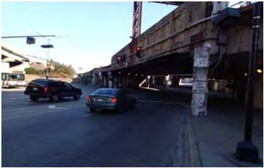

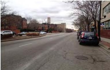
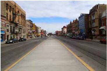


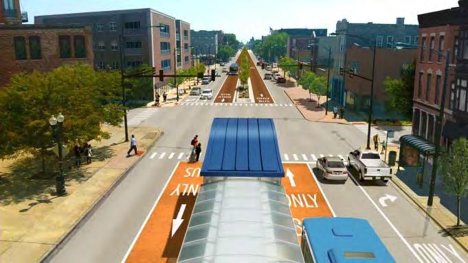
86 Figure 4-7: Current Visual Conditions at Select Intersections along Ashland Avenue Irving Park Road Belmont Avenue Cortland Street Division Street Jackson Boulevard 18 th Street Pershing Road 74 th Street 95 th Street Figure 4-8: Build Alternative Station and Alignment Concepts Page 71