Drainage Criteria Manual Review
|
|
|
- Lily Kennedy
- 5 years ago
- Views:
Transcription

1 City of Colorado Springs Stormwater Management Assessment and Standards Development Drainage Criteria Manual Review March 8, 2013 Springsgov.com/City Agencies/Stormwater/Stormwater Engineering/ Stormwater Management Assessment
2 Process Phases Phase 1 Data Collection & Scoping Phase 2 Analysis & Direction Phase 3 Document Development Phase 4 Implementation Teams Issue Groups Technical Leadership Team Executive Leadership Team Project Team Recommendation/Approval Drainage Board City Council
3 Guiding Documents Fountain Creek Watershed Project, Fountain Creek Watershed Forum, Fountain Creek Watershed Plan, PPACG, , revised 2005 Reconnaissance Study, Army Corps of Engineers, Impervious Surface Report, PPACG, 2005 Fountain Creek Watershed Study, Army Corps of Engineers, Technical Reports, Watershed Management Plan, 2009 Fountain Creek Watershed Vision Task Force Strategic Plan, 2009
4 Guiding Documents Comprehensive Plan Subdivision Policy Manual Landscape Manual Stream-side Ordinance SDS 1041 Permit City Codes/Manuals/ECM Current DCM MS4 Permit UDFCD Manual (Vol 1, 2 &3) Douglas County DCM Technical Analysis
5 Subdivision Policy Manual (July 2010) Section 4.0 Drainage Report and Plans Subsection 4.2, Requirements 1. Drainage Way Protection (Strategy NE 202c) Protect riparian areas and natural water bodies on public and private lands as natural drainage ways and ecosystems through land use plans, development plans, best management practices and ordinances. 2. Natural Ecosystem and Drainage Way Restoration (Strategy NE 202d) Promote the restoration of significant natural ecosystems, habitats for native plant and animal species, natural water bodies and drainageways on public lands, and require protection and mitigation plans for private lands during the development review process. 3. Protect Drainageway and Floodplains (Policy NE 302) Limit development of land within floodplains, which should remain, or be returned, to its natural state. Development can reduce a floodplain s ability to store and convey water, intensifying velocity and depth of floodwater in other areas.
6 Subdivision Policy Manual (July 2010) Subsection 4.2,Requirements (cont d) 4. Use Drainage Basin Planning Studies for Stormwater Management (Strategy NE 302a) - Minimize the adverse impacts of stormwater runoff, including erosion/sedimentation, to drainageways and other drainage facilities. Plan and utilize floodplains and drainageways as greenways for multiple uses including conveyance of runoff, wetlands, habitat, trails, recreational uses, utilities and access roads when feasible, considering the primary intended use. 5. Retain Floodplains in their Natural State (Strategy NE 302b) - Floodplains will remain as undisturbed riparian corridors, wildlife habitat, or wetlands whenever possible. Trails or other open recreational facilities and utility facilities such as electric, gas, and water mains may be appropriate in certain areas. Identify these areas in master plans, development plans, and development proposals.

7 SDS 1041 Permit
8 Drainage Principles Drainage is a regional phenomenon. The drainage system is a subsystem of the total urban infrastructure system. Development activity may greatly alter the amount and character of runoff. Every urban area has a minor and a major drainage system. 5. Handling runoff properly is largely a space allocation problem The diversion of storm runoff from one watershed or basin to another may introduce significant capacity and legal problems. Resources to implement drainage plans and improvements are limited. Drainage systems should be a multi-objective and multi-means effort. Natural systems possess a number of beneficial features that should be preserved and incorporated into the design of the drainage system. Natural drainage systems respond to and are dependent upon the full range of hydrologic conditions and sources of water, including snowmelt, groundwater and the full range of rainfall events. 10.The drainage system must be designed, beginning with the outlet or point of outflow from the project, giving full consideration to potential impacts and the effects of off-site flows entering the system. 11.Poorly maintained systems may not function properly, reducing their effectiveness and reducing the benefits from the economic investment required to construct them. 12.Floodplains, both regulated and unregulated, are areas of potential hazard due to high rates of runoff. 13.Drainage law places certain obligations on those who cause or oversee modifications to the natural effects of the hydrologic cycle and the conveyance of runoff overland.
9 Critical Stormwater Management Goals - Safe Flow Conveyance - Mimic Historic Flow & Volume - Channel Stabilization - Preserve Natural Channel Functions - Protect Water Quality


10 Issues IMPACT OF URBANIZATION ON STREAMFLOW STREAMFLOW RATE Large Storm Higher Baseflow Higher and More Rapid Peak Discharge More Runoff Volume Lower and Less Rapid Peak Small Storm Gradual Recessio n Pre-development Post-development TIME
11 Issues


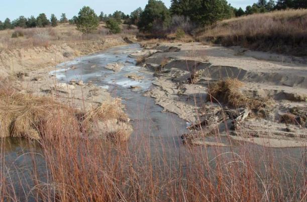
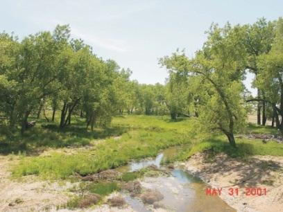
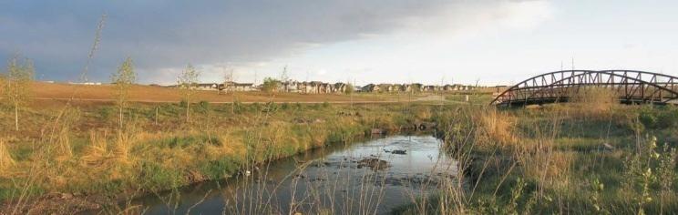
12 Issues Monument Branch tributary at confluence with Monument Creek

13 Detention Old Regional Detention


14 Detention Old Regional Detention New Regional Detention

15 Detention Regional / Multi-staged Detention Sand Creek at Constitution Basin Area = 15 SM Volume = 350 AF Height = 20 FT Pond Area = 45 AC Regional / Full Spectrum Detention University Village at Vickers Basin Area = 63 AC Volume = 5 AF Height = 10 FT Pond Area = 1.5 AC
16 Detention Capital Costs (draft Jimmy Camp Creek DBPS) Concept Detention Storage Channels Storage Land Area 4 (ac) Total Old Regional $46,450,000 $203,226, $249,676,000 New Regional/Full Spectrum $51,117,000 $134,226, $185,343,000 Difference +$4,667,000 -$69,000, $64,333,000 Notes: 1. Estimates based on draft Jimmy Camp Creek DBPS, Kiowa Eng., December, Drainage basin area is 67 square miles (42,880 acres). 2. Storage Volume: Regional, 1,935 af; New Reg/FS, 2,099 af, +9% 3. Improved channel length is about 83 miles. 4. Channel land area not calculated.
17 Detention Issue Capital Costs Phasing Dependence on Land Use Plan Floodplain Preservation Open Space Preservation Peak Flow Control Volume Mitigation Floodplain Map Revisions Erosion/ Sedimentation Land Area Required Siting Opportunities Roadway Crossing Sizes Dam Classification/ Jurisdiction Maintenance Water Quality New Regional Detention, Full Spectrum Old Regional Detention
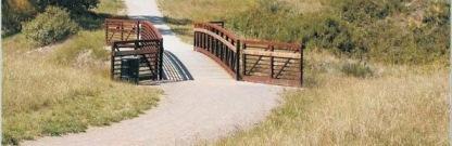
18 Open Channels
 & floodplain")
19 Open Channels Natural channel designs require flow control (detention) & floodplain preservation
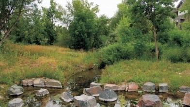
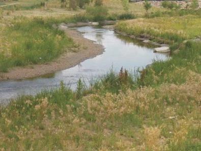
20 Open Channels Undisturbed channel on Cottonwood Creek upstream of Rangewood Dr. Designed channel on Cottonwood Creek downstream of Rangewood Dr.
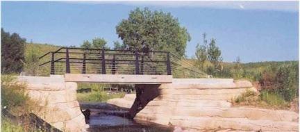
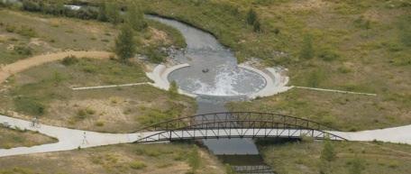
21 Open Channels Cottonwood Creek Union Blvd. to Rangewood Dr.
22 Open Channels Design Concept Cottonwood Creek Union Blvd. to Rangewood Dr. (1.2 mi (6, %) Constructed Avg. Design Slope Avg. Drop Height # Drops $ per Drop $ per Linear Foot Est. Land Area (ac) Total $ 0.5% 6 feet 10 $450,000 $ $4,500,000 Channel 1 Stabilized Natural Channel 2 0.5% 1.5 feet 41 $65,000 $ $2,665,000 Difference = +34 -$1,835,000 Notes: 1. Constructed channel costs based on completed project costs w/o admin. or engineering costs. 2. Stabilized natural channel costs based on conceptual estimate w/o admin. or engineering costs.
23 Open Channels Issue Constructed Channel Stabilized Natural Channel Capital Costs Phasing Dependence on Land Use Plan Floodplain Preservation Open Space/Habitat Preservation Aesthetics Groundwater Recharge Floodplain Map Revisions Erosion/ Sedimentation Land Area Required Water Quality Roadway Crossing Sizes Environmental Permits Maintenance
24 Stormwater Quality Best Management Practices Land Planning Configurations Buffers Clusters Minimize directly connected imperviousness Infiltration Stabilize channels Source controls Water quality capture volume Erosion and Sediment Control during Construction Transfer of permit to builder Effective Imperviousness Application of Permanent BMPs to all Land Uses Water Quality Above State waters
25 Drainage Principles Drainage is a regional phenomenon. The drainage system is a subsystem of the total urban infrastructure system. Development activity may greatly alter the amount and character of runoff. Every urban area has a minor and a major drainage system. 5. Handling urban runoff properly is largely a space allocation problem The diversion of storm runoff from one watershed or basin to another may introduce significant capacity and legal problems. Resources to implement drainage plans and improvements are limited. Drainage systems should be a multi-objective and multi-means effort. Natural systems possess a number of beneficial features that should be preserved and incorporated into the design of the drainage system. Natural drainage systems respond to and are dependent upon the full range of hydrologic conditions and sources of water, including snowmelt, groundwater and the full range of rainfall events. 10.The drainage system must be designed, beginning with the outlet or point of outflow from the project, giving full consideration to potential impacts and the effects of off-site flows entering the system. 11.Poorly maintained systems may not function properly, reducing their effectiveness and reducing the benefits from the economic investment required to construct them. 12.Floodplains, both regulated and unregulated, are areas of potential hazard due to high rates of runoff. 13.Drainage law places certain obligations on those who cause or oversee modifications to the natural effects of the hydrologic cycle and the conveyance of runoff overland.
26 Review/Approval Process April 4, 3:00 PM Drainage Board Recommendation, City Hall, Council Chambers April 22, 1:00 PM Informal City Council, City Hall, Council Chambers April 23, 1:00 PM City Council Resolution, City Hall, Council Chambers
27 SpinSpin-off Projects Project Description 1) Site Planning and Design Standards - Evaluate Site Planning and Design standards to identify opportunities for change that will mitigate stormwater runoff increases due to development. 2) Floodplain Administration - Evaluate policies related to floodplain administration to identify changes to make the policies more consistent with stormwater management goals. 3) Improvement Phasing - Evaluate a policy for phasing improvements based on level of development in the upstream basin or anticipated downstream impacts. 4) Watershed-wide Issues Evaluate watershed-wide issues and technical solutions to identify changes to the manuals to make them more applicable throughout the Fountain Creek watershed. Estimated Cost $92,000 $99,000 $40,000 $170,000
28 Issues Sand Creek - upstream of regional ponds at Barnes Rd., looking upstream Sand Creek - downstream of regional ponds at Constitution, looking upstream
29 New Approaches More Natural Designs Courtesy of Denver UDFCD
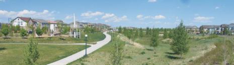
30 Multi-function Designs Courtesy of Denver UDFCD


31 Better Integration with Land Plan Courtesy of Denver UDFCD
32 Summary Extensive stakeholder process/buy-in Implementing Fountain Creek Strategic Plan and Comprehensive Plan recommendations Current standards/methods are inadequate Developed and applied advanced methods to estimate and control flows, improve water quality and reduce capital costs Spin-off projects are needed to expand the scope of the project to be more comprehensive (additional $401,000 is committed) Working toward watershed-wide acceptance and adoption of standards Further study needed to improve understanding and methods
33 Confused? Questions? Comments?