JOINT PUBLIC NOTICE Savannah District/State of Georgia
|
|
|
- Francine Clemence Hodge
- 5 years ago
- Views:
Transcription
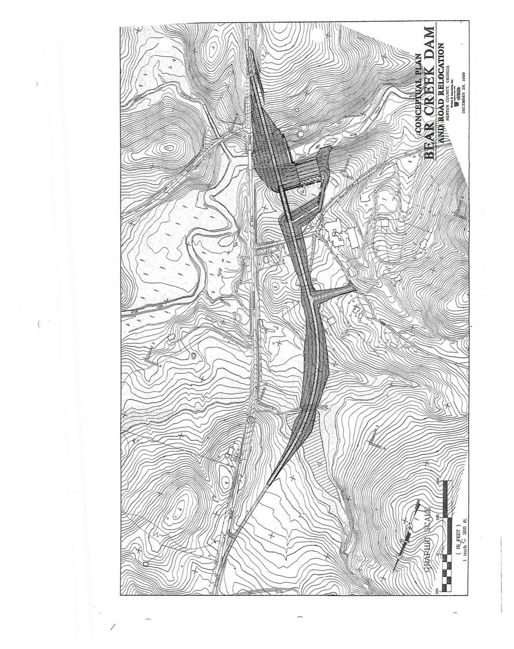
1 UEPARTMENT OF THE ARMY SAVANNAH DISTRICT, CORPS OF ENGINEERS 100 W. OGLETHORPE AVENUE SAVANNAH, GEORGIA Regulatory Branch JOINT PUBLIC NOTICE Savannah District/State of Georgia The Savannah District has received an application for a Department of the Army Permit, pursuant to Section 404 of the Clean Water Act (33 U.S.C. 1344), as follows: Application Number: Applicant: Newton County Board of Commissioners 1124 Clark Street Covington, Georgia Agent: Wm. Thomas Craig Post Office Box 1587 Covington, Georgia Location of Proposed Work: The site is located immediately downstream of Henderson Mill Road Bridge over Bear Creek, at latitude 33 27' 29" north and longitude 83 48' 11" west, in southeast Newton County, Georgia. Description of Work Subject to the Jurisdiction of the US Army Corps of Engineers: To impact 136 acres of wetland and 24 miles of stream in order to construct a dam, 1,242-acre pump-storage reservoir, Bear Creek Reservoir. The reservoir's primary purpose would be to provide a reliable source of public water supply capable of satisfying the projected unmet water supply demand during drought conditions in the Service Area of Newton County for the projected population through the year The project would also require the installation of 6,000 linear feet of force main pipeline to augment reservoir storage by pumping water from the Alcovy River. The dam would be 1450 feet long, 62 feet high, and 350 feet wide at the base. The reservoir would have an area of approximately 1,242 acres at a full pool elevation of 642 msl, and supply approximately 28 million gallons per day. Impacts of the project on infrastructure would include the inundation of 10 residences and portions of Macedonia Road, Gaithers Road (formerly Davis Ford Road), Benton Road, Old Post Road, and Henderson Mill Road. Most of these would be dead-ended outside of the normal pool of the reservoir. However, it would be necessary to relocate Henderson Mill Road over the top of the dam. Accommodations would need to be made for an existing transmission line and right-of-way. It would also be necessary to acquire buffer easement over the 150-foot buffer immediately adjacent to the normal pool, an easement for the flood pool, and an easement to accommodate the pipeline from the Alcovy River.

2 In order to mitigate these impacts to the aquatic environment, the. applicant proposes stream mitigation totaling 3,750 linear feet of restoration, 26,030 linear feet of riparian buffer enhancement, and 138,690 linear feet of riparian preservation. For wetland mitigation, the applicant proposes 96 acres of restoration, acres of enhancement, and 325 acres of preservation. This mitigation would occur at eleven different areas located within the Upper Ocmulgee watershed. Sites would be monitored in accordance with a monitoring plan to assure success and in the event success was not shown, a contingency plan would be followed. All mitigation areas would be preserved in perpetuity through restrictive covenant. BACKGROUND Application for a similar reservoir at this location was advertised in a June 9, 2000, Joint Public Notice. While evaluating that application, the USACE determined that information was insufficient to adequately evaluate the proposal and the application was withdrawn. This Joint Public Notice announces a request for authorizations from both the US Army Corps of Engineers and the State of Georgia. The applicant's proposed work may also require local governmental approval. STATE OF GEORGIA Water Oualitv Certification: The Georgia Department of Natural Resources, Environmental Protection Division, intends to certify this project at the end of 30 days in accordance with the provisions of Section 401 ofthe Clean Water Act, which is required by an applicant for a Federal Permit to conduct an activity in, on, or adjacent to the waters ofthe State of Georgia. Copies of the application and supporting documents relative to a specific application will be available for review and copying at the office of the Georgia Department ofnatural Resources, Environmental Protection Division, Water Protection Branch, 4220 International Parkway, Suite 101, Atlanta, Georgia 30354, during regular office hours. A copier machine is available for public use at a charge of 25 cents per page. Any person who desires to comment, object, or request a public hearing relative to State Water Quality Certification must do so within 30 days of the State's receipt of application in writing and state the reasons or basis of objections or request for a hearing. The application can also be seen in the Savannah District US Army Corps of Engineers, Regulatory Branch, 100 West Oglethorpe A venue, Savannah, Georgia. State-owned Property and Resources: The applicant may also require assent from the State of Georgia which may be in the form of a license, easement, lease, permit, or other appropriate instrument. US ARMY CORPS OF ENGINEERS The Savannah District must consider the purpose and the impacts of the applicant's proposed work, prior to a decision on issuance of a Department of the Army Permit. Cultural Resources Assessment: Presently unknown archaeological, scientific, prehistorical, or historical data may be located at the site and could be affected by the proposed work. A Phase 2

3 I Cultural Resources report entitled "Cultural Resources Survey and Archeological Testing Proposed Bear Creek Reservoir Newton County, Georgia," dated September 13, 2002, was included with the application. That report is under review by the U~ACE and the Georgia Department of Natural Resources, Historic Preservation Division, to determine the proposed project's effect to historical, archaeological or architectural resources. Endangered Species: The applicant conducted a survey of the project area and found no evidence of the presence or past use by terrestrial threatened or endangered species. Newton County could potentially provide habitat for: the red-cockaded woodpecker, Picoides borealis (E); the bald eagle, Haliaeetus leucocephalus (T); the wood stork, Mycteria american (E); little amphianthus, Amphianthus pusillus (T); black-spored quillwort, Isoetes melanospora (E); and Michaus's sumac, Rhus michauxii (E). According to information submitted by the applicant, an endangered species survey was conducted. The survey found no individuals and suitable habitat for only two species, little Amphianthis and black-spored quillwort. One granite outcrop was found that could potentially support these two species. Neither species could be found there. Based on this information, the Savannah District has reached a preliminary determination that the proposed project would not affect any Federally listed threatened or endangered species that are under the purview of US Department of the Interior, Fish and Wildlife Service (FWS). Pursuant to Section 7(c) of the Endangered Species Act of 1973, as amended (16 U.S.C et seq.), we request concurrence on this determination from the FWS. Public Interest Review: The decision whether to issue a permit will be based on an evaluation of the probable impact including cumulative impacts of the proposed activity on the public interest. That decision will reflect the national concern for both protection and utilization of important resources. The benefit which reasonably may be expected to accrue from the proposal must be balanced against its reasonably foreseeable detriments. All factors which may be relevant to the proposal will be considered including the cumulative effects thereof; among those are conservation, economics, aesthetics, general environmental concerns, wetlands, historic properties, fish and wildlife values, flood hazards, flood plain values, land use, navigation, shoreline erosion and accretion, recreation, water supply and conservation, water quality, energy needs, safety, food and fiber production, mineral needs, considerations of property ownership and in general, the needs and welfare of the people. Consideration of Public Comments: The US Army Corps of Engineers is soliciting comments from the public; federal, state, and local agencies and officials; Native American Tribes; and other interested parties in order to consider and evaluate the impacts of this proposed activity. Any comments received will be considered by the US Army Corps of Engineers to determine whether to issue, modify, condition or deny a permit for this proposal. To make this decision, comments are used to assess impacts on endangered species, historic properties, water quality, general environmental effects, and the other public interest factors listed above. Comments are used in the preparation of an Environmental Assessment and/or an Environmental Impact Statement pursuant to the National Environmental Policy Act. Corriments are also used to determine the need for a public hearing and to determine the overall public interest of the proposed activity. 3
4 Application of Section 404(b)(l) Guidelines: The proposed activity involves the discharge of dredged or fill material into the waters of the United States. The Savannah District's evaluation of the impact of the activity on the public interest will include application of the guidelines promulgated by the Administrator, Environmental Protection Agency, under the authority of Section 404(b) ofthe Clean Water Act. Public Hearing: Any person may request, in writing, within the comment period specified in this notice, that a public hearing be held to consider this application for a Department of the Army Permit. Requests for public hearings shall state, with particularity, the reasons for requesting a public hearing. The decision whether to hold a public hearing is at the discretion of the District Engineer, or his designated appointee, based on the need for additional substantial information necessary in evaluating the proposed project. Comment Period: Anyone wishing to comment on this application for a Department of the Army Permit should submit comments in writing to the Commander, US Army Corps of Engineers, Savannah District, Attention: Regulatory Branch, Post Office Box 889, Savannah, Georgia , no later than 30 days from the date of this notice. Please refer to the applicant's name and the application number in your comments. If you have any further questions concerning this matter, please contact Jason O'Kane at (912) Attachments 1. Vicinity Map 2. Location Map 3. Plan View Drawing 4

5 Newton County, Georgia Map Showing Watershed Divide

6 ,.:. Bear c,.jk Drainage Area= 31.6 s.m. Pool Elev. = 642 Feet msl Pool Area = 1242 Acres Volume = 5.5 Billion Gal. Yield = 28 MGD (w/pumping) -f-_.. '. 1-~ '...-/ ,_o i -!~ ~.~, -~ I., '....,.. ; _. I ;.. :... ~ '\.,.,.,... ~; ; _. _... _.~ ':. : \ J.. ~.., ('.;~...,IJI, I ~\ ' - f} ~.. \' \ \ r \ ~ '~~- '...::.:..';::> -~.
7 I