Gumboot Run Biological Assessment McKean County, Pennsylvania
|
|
|
- Ernest Holland
- 5 years ago
- Views:
Transcription
1 Gumboot Run Biological Assessment McKean County, Pennsylvania By: Elias J Heferle Water Pollution Biologist II Pennsylvania Department of Environmental Protection Knox District Mining Office January 2005
2 Introduction The Knox District Mining Office (Knox DMO) conducted an assessment of the aquatic macroinvertebrate communities in Gumboot Run on September 11, The assessment was performed in order to determine the negative impacts that several mine discharges and seeps were having on the biological community of Gumboot Run, before passive treatment implementation and to facilitate a comparison and analysis of water quality improvements/accomplishments from treatment. Watershed Description Gumboot Run is located in Sergeant Township, McKean County, and has a drainage area of approximately 1.4 square miles. Originating one mile south of the town of Clermont, Gumboot Run flows approximately 2.3 miles from its headwaters in a southwestwardly direction to its confluence with the East Branch Clarion River (Appendix A). The East Branch Clarion River flows into the 2.0 square mile East Branch Lake which is formed by the East Branch Dam. The dam was constructed in 1952 by the United States Army Corps of Engineers (USACE) for flood control and recreation. Watershed History Deep mining in the Gumboot Run Watershed started in the Gumboot Mines during the late 1800s and produced coal until the early 1900s. Seeps along the cropline between two mine openings that were sealed during the 1970s are the major source of abandoned mine drainage (AMD) in the watershed. Early remediation and reclamation projects (mine sealing and draining, the addition of hydrated lime, and grading and vegetating spoil) were initiated in the East Branch Watershed after the Operation Scarlift investigation (SL-180, Michael Baker, Jr. Inc.) was completed in Remediation efforts in the watershed accelerated in 1996 with lime sand application initiated by the USACE and the Elk County Conservation District and gave rise to development of a partnership led by the Elk County Fishermen. This partnership, dedicated to restoration of the Upper East Branch watershed and aquatic habitat improvement, has expanded to include Willamette Industries, Pa. Fish and Boat Commission, Department of Conservation and Natural Resources, North Central Regional Planning and Development Commission, Elk County Commissioners, Bureau of Abandoned Mine Reclamation (BAMR), and the Knox DMO. The Knox DMO updates restoration and remediation activities in the watershed annually, in the East Branch Clarion River Watershed Updates. Water Quality Several discharges and in-stream monitoring points in the Gumboot Run watershed were identified and sampled by the Knox DMO since 1996 (Appendix B and Table 1). The headwaters of Gumboot Run (GB1) exhibit good water quality with net alkalinity and low metal levels. Downstream monitoring points (GB4B, GBR1 & GB8) show an increasing trend in acidity and a decrease in alkalinity resulting from several seeps and discharges (GB2, GB3 & GB5) emanating from the Gumboot Mine complex. Water quality at the mouth of Gumboot Run (GB11) begins to show signs of improvement, but is net acidic (Table 1).
3 Table 1: Gumboot Run Watershed Monitoring Points: Average Flow and Chemistry. Monitoring Flow Alkalinity Acidity Iron Manganese Aluminum Sulfate Point (GPM) ph (mg/l) (mg/l) (mg/l) (mg/l) (mg/l) (mg/l) GB < <0.5 <20 GB <0.5 <20 GB4B < <0.5 <20 GBR GB GB GB GB GB < < Based on the water quality data collected, the Knox DMO installed a 900-ton limestone vertical flow passive treatment system within the stream channel to add alkalinity, increase ph and decrease acidity in Gumboot Run. The system was completed in November 2001 and has shown an increase in water quality below the treatment system effluent (GB4). However, several months after the system was constructed, water quality at the downstream monitoring point (GB8) began to show signs of increased acidity, thus negating the additional alkalinity produced by the in- stream treatment (Table 2). Table 2: GB4 and GB8 Water Quality: Average Flow and Chemistry Before and After Gumboot Run Treatment System Installation. Monitoring Flow Alkalinity Acidity Iron Manganese Aluminum Sulfate Point (GPM) ph (mg/l) (mg/l) (mg/l) (mg/l) (mg/l) (mg/l) Before GB <.5 <20 After GB <.5 <20 Before GB After GB The cause of the increased acidity downstream at GB8 was determined to be from several abandoned mine discharges and seeps emanating from the Gumboot Mine complex that had been sealed and reclaimed in the 1970 s. BAMRs Cambria office staff is currently evaluating data collected by the Knox DMO and collecting additional water quality data from mine pools via boreholes in order to determine the appropriate treatment system design. Once the conceptual design is completed, the project will be let in early 2005 with construction expected to begin during the summer of The water quality of the East Branch Clarion River upstream from its confluence with Gumboot Run (50EB) shows a high acidity due to several deep mine discharges and seeps on Two Mile Run. Downstream from its confluence with Gumboot Run (49EB)
4 the East Branch Clarion River shows a slight increase in ph and alkalinity, along with a slight decrease in acidity due to the dilution that is occurring after the streams mix together (Table 3). Table 3: 50EB and 49EB Water Quality: Average Chemistry Upstream and Downstream of Gumboot Run. Monitoring Flow Alkalinity Acidity Iron Manganese Aluminum Sulfate Point (GPM) ph (mg/l) (mg/l) (mg/l) (mg/l) (mg/l) (mg/l) 50EB <.5 <20 49EB <.5 <20 Biological Assessment Macroinvertebrate samples were collected at three locations in the Gumboot Run Watershed, including the headwaters of Gumboot Run (GB1), Gumboot Run downstream from the Gumboot Mine discharges/seeps (GB8), and at the mouth of Gumboot Run (GB11) (Appendix B). At each location, samples were collected from representative riffle and run sections of the stream with a D-frame dip net, placed into 1.5 Liter containers and preserved with 95% ethanol. In the lab, preserved samples were rinsed with tap water, sorted and organisms were identified to the genus level. (A complete list of the organisms identified at the three sampling locations can be found in Appendix C). Three indices were used to characterize the biological data at each site: Abundance, Taxa Richness, and % EPT (Ephemeroptera, Plecoptera, Trichoptera). Abundance is the overall number of individual organisms found at each location. Taxa Richness represents the health of the aquatic community through its diversity, and increases with habitat diversity and water quality. The healthier the community, the greater the number of taxa found within the community. Ephemeroptera, Plecoptera and Trichoptera are considered to be sensitive to poor water quality conditions; therefore the presence of these organisms is generally an indicator of good water quality. The higher the populations of these organisms, the more stable the site (Plafkin, et al., 1989). The macroinvertebrate samples collected at GB1 showed the greatest species abundance and taxa richness when compared to GB8 and GB11 (Table 4). Although the %EPT at GB1 was the lowest of the three sites, GB1 contained the greatest amount of these species (86), represented by seven different taxa. The diverse aquatic community at this site, rich in EPT taxa, reflects the good water quality that has been documented at GB1 (Table 1). Table 4: Macroinvertebrate Abundance, Taxa Richness and %EPT for sampling locations in Gumboot Run. Location Abundance TR %EPT Headwaters of Gumboot Run (GB1) Gumboot Run Downstream Discharges (GB8) Mouth of Gumboot Run (GB11)
5 The macroinvertebrate community at GB8 was characterized by a low abundance and taxa richness, when compared to GB1 and GB11, with only 30 total organisms being found, representing 5 taxa (Table 4). Although the %EPT at GB8 was higher than at GB1, only one species of Trichoptera comprised this percentage. The low diversity of taxa represented in the GB8 biological community is indicative of the net acidic, lower ph water quality found at this site (Table 1). The upstream discharges and seeps from the Gumboot Mine are impairing the water quality and in turn the biological community at this site. The substrate at this site was encrusted with iron precipitate, which decreases available habitat and contributes to the depressed macroinvertebrate community. The macroinvertebrate community at GB11 contained 31 less organisms and five fewer taxa when compared to the community at GB1, from the unimpaired headwaters of Gumboot Run (Table 4). The %EPT was highest at this sampling site (89.9) and was comprised of 79 individuals from 7 different taxa. The biological community at this site shows signs of significant improvement, compared to the upstream community below the mine discharges (GB8) and is reflected in the water quality collected at the mouth of Gumboot Run (GB11) (Table 1). The presence of net acidic water at GB11 contributed from the Gumboot Mine discharges, accounts for the lower abundance and taxa richness at this site, compared to the macroinvertebrate community at GB1. Improvements in water quality in Gumboot Run are anticipated once a treatment system is installed on Gumboot Run, based on BAMRs study of the Gumboot Mine discharges and treatment system design. It is also anticipated that improvements in water quality will result in a healthier, more diverse biological community downstream from the treatment system in Gumboot Run. Along with this remediation project, a passive treatment system is currently being constructed to treat the deep mine discharges on Two Mile Run. This project was funded by a $175, DEP Growing Greener Grant and a $110, grant from the Federal Office of Surface Mining (OSM), Appalachian Clean Streams Initiative. Headwaters Charitable Trust is the sponsor/project manager for the grantee, the Elk County Fishermen.. The combination of these two systems will decrease the acidity loading and provide for additional alkalinity to improve the water quality in Gumboot Run, Two Mile Run,in the East Branch Clarion River and the East Branch Lake. The Knox DMO will continue to monitor the water quality and perform a follow up assessment of the biological community once the Gumboot Run discharge treatment systems are implemented and fully functional for at least one year. References Plafkin, J.L., M.T. Barbour, K.D. Porter, S.K. Gross, and R.M. Hughes Rapid bioassessment protocols for use in streams and rivers: Benthic macroinvertebrates and fish. U.S. Environmental Protection Agency, Office of Water Regulations and Standards, Washington, D.C. EPA
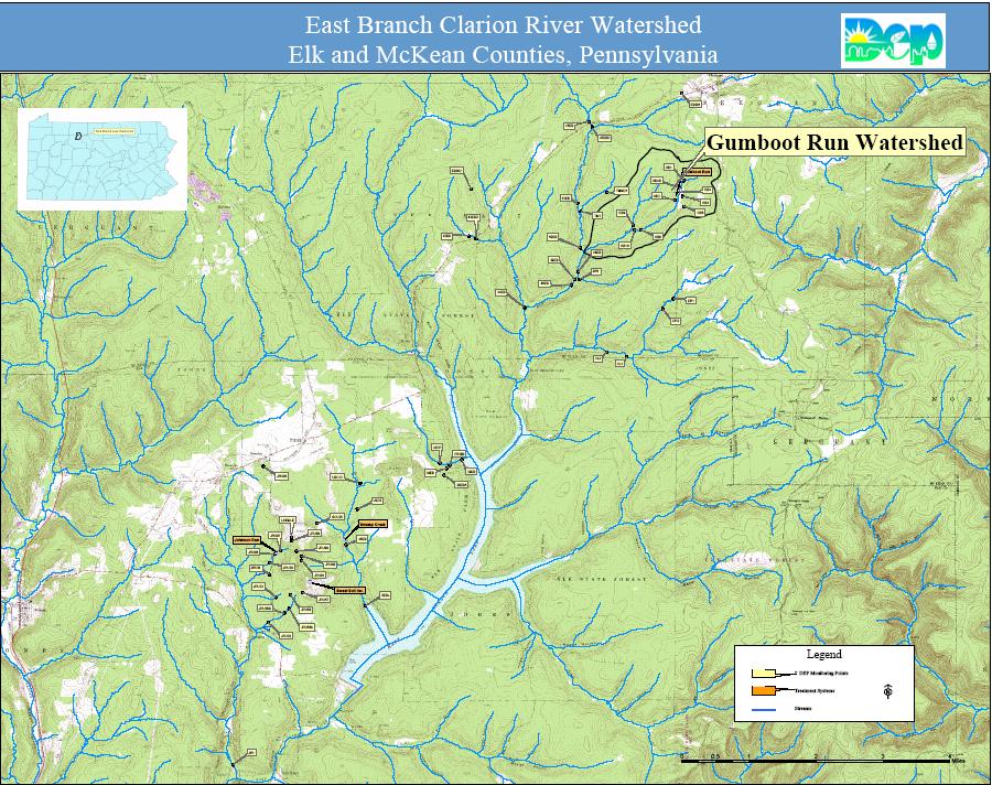
6 Appendix A East Branch Lake and Gumboot Run Watershed Map
7
8 Appendix B Gumboot Run Watershed Monitoring Points

9
10 Appendix C Benthic Macroinvertebrates Collected in the Gumboot Run Watershed
11 Gumboot Run Gumboot Run Gumboot Run d.s. pipeline crossing d.s. culvert mouth Map Reference GB1 GB8 GB11 EPEMEROPTERA (MAYFLIES) Ephemerellidae Eurylophella sp. 1 3 PLECOPTERA (STONEFLIES) Nemouridae Amphinemura sp. 3 Leuctridae Leuctra sp Capniidae 12 3 Perlodidae 1 TRICHOPTERA (CADDISFLIES) Hydropyschidae Diplectrona sp Hydroptilidae Rhyacophilidae 2 Rhyacophila sp. Limnephilidae COLEOPTERA (BEETLES) Elmidae Stenelmis sp. 2 Hydrophilidae 1 DIPTERA (FLIES) Chironomidae Ceratopogonidae 1 Tipulidae Tipula sp. 1 Dicranota sp. 3 Tabanidae Simuliidae Simulium sp. 6 CRUSTACEA (CRAYFISH, AMPHIPODS. ISOPODS) Decapoda Cambaridae 3 1 MEGALOPTERA (ALDER-, DOBSONFLIES) Corydalidae Nigronia sp. 1 Total Number Taxa (Richness) Total Number Insects (Abundance) % Ephemeroptera, Plecoptera, Trichoptera