CLIMATE CHANGES SCENARIOUS AND THEIR IMPACTS ON INTERACTIONS ON FOREST AND AGRICULTURE
|
|
|
- Asher Cox
- 5 years ago
- Views:
Transcription
1 CLIMATE CHANGES SCENARIOUS AND THEIR IMPACTS ON INTERACTIONS ON FOREST AND AGRICULTURE Brunini, O 1.; Carvalho, J.P 2.; Ciarelli, V.B 3.; Brunini, A.P.C Agrometeorologist PhD. Instituto Agronômico de Campinas Secretaria de Agricultura e Abastecimento-FUNDAG- São Paulo- Brazil. brunini@iac.sp.gov.br 2- Soil Scientist. Instituto Agronômico de Campinas 3- Graduate Student Fellowship- Instituto Agronômico de Campinas 4- Environmental Biology-MSc. NB and FUNDAG- São Paulo-Brazil

2 SUMMARY The different conditions of climatic changes on the agricultural-forestry exploration in the State of Sao Paulo Brazil were evaluated in this work. The results demonstrated that the possible scenarios for climatic change have a very specific effect upon the recovery of areas under reforestation and even on sustainable exploration. Climatic change scenarios were established ranging from a 2 C cooling to a 6 C. The combined effect of climate change in response to the increase in air temperature and a possible reduction in the total amount of rainfall was also evaluated.
3 Main Objectives The main goal of the study was to provide scientific support to potential conflicts between the use of land, basically for sugar cane mills, agriculture exploitation and forest preservation aiming at preserving by a biodiversity and economic growth To consider the debate on the legal reserves and the capability for land use, an integrated assessment methodology was developed and applied to the various physical and biotic environments in order to indicate the levels of priority in the forest recovery for the State of São Paulo
4 INTRODUCTION The relation between environmental conservation and economic development has led to debate actors with point views belonging to a wide spectrum of positions. Inherent in this debate can be identified options for partial views of reality. These approaches are often built on scientific arguments equally partial and coated technical language. In the first paragraph of article of the decree state is determined that the areas of Legal Reserve are established seeking the "sustainable use of natural resources, conservation and rehabilitation of ecological processes, conservation of the biodiversity and shelter and protection of native flora and fauna. There are few actors who deny the importance of this function. The economic costs of the measure are presented and discussed widely, but on the other hand, it is still necessary scaling of the cost of loss of biodiversity, genetic erosion, habitat loss and fragmentation of the landscape. The determination of economic values for biodiversity, allows comparisons are undertaken between the profits obtained by maintaining of the current situation and the gains from restructuring the segments of the original vegetation. In despite of the importance of this approach, some studies describe that the solutions thus obtained can not be unequivocal. (Nunes & van den Bergh, 2001, p. 218).
5 MATERIAL AND METHODS Analysis and simulations were undertaken for the entire territory of the State of São Paulo, Brazil. Several sources of cartographic and climatic information were employed, with different scales and levels of details. The characteristics of the data and the analysis are now detailed.
6 Database The first activity consisted in the creation of an assessment model to achieve the objectives of the project. In this phase, the types of data and information that should be integrated and analyzed were identified. Aiming at indicating the level of priorities most appropriate for the conservation demand and increase in biodiversity, the selected variables were divided into two major groups, namely: data from the physical environment and from the biotic environment. The Geographic Information System (GIS) used for the assessment was the ArcGIS. This software has the capacity necessary for storing, managing and processing the data. The characteristics of soils, topography, climate and groundwater were considered as important variables of the physical environment. The soils data used were derived from Soil Survey Map of Sao Paulo. From the SRTM elevation data was calculated the declivity of the strands using spatial analysis in GIS. These data were classified in ranges of 0-3%, 3-6%, 6-12%, 12-20%, 20-40% and >40% of decline. The data of precipitation discounting potential evapotranspiration were used to characterize the climate model. Another variable used in the analysis was the vulnerability of aquifers, however, data available in digital media representing only the aquifers are considered vulnerable.
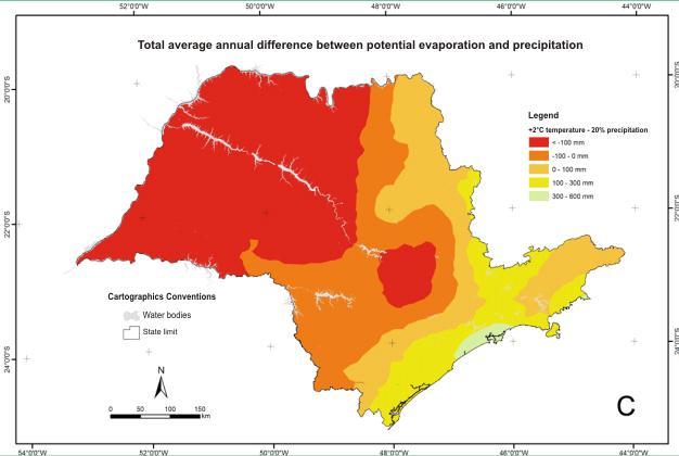
7 Climate The dry period that affects the southeastern regions, especially in the State of Sao Paulo, lasts from May to September, whose predominant climatic variables are of low precipitation and of low temperatures affecting the replenishment of the aquifers. The high demand on water for irrigation and for human consumption has placed several regions or watersheds of the State of Sao Paulo in a critical situation or with a tendency toward restraint Current projections estimate global warming to be between 2 C and 6 C for the next 80 years (2080). on the other hand, some researchers claim that global cooling is expected for the next decades. In this context, scenarios for changes in the temperature regime were defined, considering increases of 2 C to 6ºC in the average annual temperature and with annual precipitation totals equal to the current standard, with a reduction of 20% and an increase of 20%. Additionally, a scenario of cooling was considered, with a reduction of 2 C in the average atmospheric temperature, with the same precipitation patterns above.
8 Remarks It should also be noted that in a climatic change situation extreme meteorological events will occur with greater frequency, in other words, longer drought periods and even high rainfall in a restricted region. This situation will have direct effect on the preservation of water resources and their adoption in irrigated agriculture, which could compromise the agricultural use of water if there are not appropriate criteria to mitigate the effects of adversities such as drought or prolonged dry spells


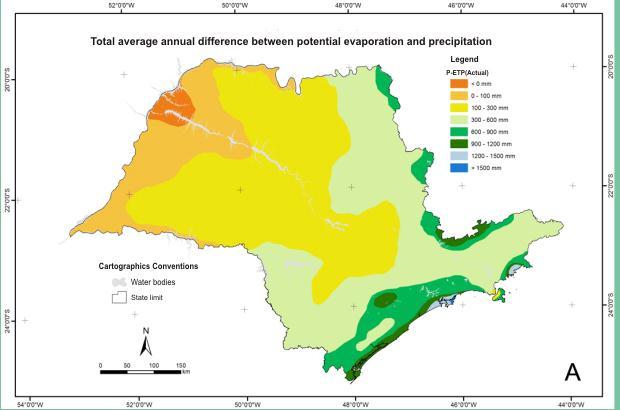
9 CLIMATE CONDITIONS-ACTUAL Average annual rainfall SP- Brazil Annual average temperature SP - Brazil
10 Some results Considering projections of global warming to be between 2 C and 6 C ; With annual rainfall precipitation totals equal to the current standard; With a reduction of 20% and an increase of 20%; A cooling scenario, with a reduction of 2, with the same rainfall precipitation patterns;
11 Scenarios being discussed Actual situation Warming of 2ºC and same rainfall Warming of 2ºC and 20% reduction in rainfall Cooling of 2ºC with same rainfall pattern
12 Maps of priorities The basic maps were reclassified into priority levels, as rules aimed at the best use of land. The crosses were made between pairs of maps and the results again reclassified into priority levels. The result of this analysis was crossed with the priority information plan of conservation unities. The difference between precipitation and potential evapotranspiration (actual and scenario) was the next layer of data used in the analysis.

13 Classes of priority from the capacity of land use Capacity of land use Priorities I Low for forests / high for agriculture II e III Medium-low for forests / medium-high for agricluture IV e VI Medium-high for forests / medium-low for agriculture V, VII e VIII High for forests / low for agriculture

14 Thematic maps reclassified into priorities capacity of land use connectivity


15
16 Classes of priority from climate data P-ETP (mm) Priorities > 300 Low for forests / high for agriculture Medium-low for forests / medium-high for agricluture Medium-high for forests / medium-low for agriculture < 0 High for forests / low for agriculture


17
18

19
20 Conclusions The methodology adopted depends crucially of the availability of geospatial data on the scale and resolution adequate, thus the results presented are for analysis at the state level or regional level. From among the three scenarios considered only one led to expansion of areas with higher priorities to agricultural uses, especially the situation that causes vigorous debates among experts, ie, the decrease of 2 C. In order for proposals can be made on a firmer basis, and taking into account possible environmental alterations derived from climatic changes, considering both the scenario of an increase of 2 C and that considers this increase in temperature with the decrease in precipitation leads to augment in areas that could or should be occupied with forest uses, especially uses that lead to water conservation and enhance percolation through the soil profile.