ENVIRONMENTAL MANAGEMENT PLAN PHASIGUDA SAND QUARRY. For Sri Kalu Charan Behera. Prepared By AMARESH RATH RQP/OD/076/2017
|
|
|
- Reynold Morgan
- 5 years ago
- Views:
Transcription
1 ENVIRONMENTAL MANAGEMENT PLAN OF PHASIGUDA SAND QUARRY OVER AN AREA OF ACRE / HA IN VILLAGE PHASIGUDA OF DIGAPAHANDI TAHASIL OF GANJAM DISTRICT OF ODISHA. For Sri Kalu Charan Behera Village - Purunamoulabhanja, Ps - Digapahandi, Dist- Ganjam. Prepared By AMARESH RATH RQP/OD/076/2017 1
2 1. Introduction Environmental Management Plan (EMP) consists of a set of impact mitigation, management, monitoring, waste minimization and institutional measures to be taken during implementation and operation of the project to eliminate the adverse environmental impacts or to reduce them to the acceptable level. The EMP is required to ensure sustainable development as it tries to ensure judicious utilization of non-renewable resources and keep the pollution level within permissible assimilative capacity of the area. The assimilative capacity of the study area is the maximum amount of pollution load that can be discharged in the environment without affecting the designated use and is governed by dilution, dispersion and removal due to natural physicochemical and biological processes. Mining, environment and development have become complimentary to each other. EMP identifies the extent of the environmental, social and economic impacts of a project prior to mining of mineral and systematically examines both beneficial and adverse impacts of the proposed project over and above the prevailing conditions of environmental parameters and ensure that these impacts are taken into account during the project designing stage itself and the values of the combined impacts are never allowed to exceed and remain within the statutory norms. The EMP has been prepared with a view to ultimately ensure the adverse impacts are minimized if these cannot be prevented altogether. Indeed, in a developing country like India, the supply of sand & gravel as a raw material for infrastructure development has a paramount importance. Therefore, the implementation of scientific mining principles through emp plays a vital role in sustainable economic growth of our country. Benefits of sustainable sand mining Prevents the river bed from becoming shallow due to the deposition of sediments. Scientific mining prevents the excessive erosion, which can damage flora, agriculture land and settlements situated in close proximity. It maintains the water retention capacity and help to avoid flood like situations. It generates useful economic resource for construction and generates employment in local areas. This project is meant for exploitation of ordinary sand i.e. Phasiguda sand quarry as minor mineral over an area of acres or Ha.The project site is located in village Phasiguda, Tahasil- 2
3 Digapahandi, District Ganjam, Odisha. The revenue department, Govt. of Odisha has granted the lease in favour of Sri Kalu Charan Behera, At/ Po - Purunamoulabhanja, Digapahandi, District-Ganjam, State- Odisha for 5 (five) years from Digapahandi to As per Govt. of India Notification regarding Environmental Clearance Notification of 14th September, 2006 and its subsequent amendment of 24th Dec., 2013 and 15th Jan., 2016, the lessee intended to obtain Environmental Clearance from State Environment Impact Assessment Authority (SEIAA), Odisha for a production capacity of cum/ annum of river sand. 2. Brief Description Of The Project The study area where the mining will be done is situated on the banks of Ghorhaharh River. The mining lease area is bounded by latitude of N to N and longitude of E to E. in the Topo sheet no. 74/11. It is a part of dry river bed for more than 8 months in a year except for the monsoon & post monsoon season. The water flows on the Northern side of the mine lease area. The flow of water is from North west to South east direction. The sand mining up to the depth of 0.5m will have insignificant impact on water regime. During mining the quantity of material excavated, will be filled up when flood water flows over that area in monsoon season. During dry season the ML area will be devoid of surface water whereas during monsoon season the total lease area will be under water. Annual removal of sand from the river bed is not only commercially beneficial but it also helps in clearing the river bed for flow of excess water especially during the rainy season. STATUS OF THE LESSEE Lessee Sri Kalu Charan Behera is a Private Individual with sound financial background and experience in identification, mining and marketing of Sand. Sand Bed in the M.L area is proposed to be mined out by Manual open cast method of mining. 3
4 Table 1: Description Of The Project Sl. No. Particulars Details 1. Profile of The Project River sand mining project in Ghorhaharh river 2. Name & Address of the Lessee Sri Kalu Charan Behera At/ Po - Purunamoulabhanja, Ps - Digapahandi, Dist-Ganjam. 3. Grant of Lease Quarry lease has been proposed to be granted by the Tahasildar Digapahandi. Project Location 4. Village Phasiguda 5. Tehsil Digapahandi 6. Plot No Khata No Kissam Nadi 9. District Ganjam 10. Toposheet No. 74/ Latitude & Longitude Latitude N to N and longitude of E to E. Mining Particulars 13. Status of Mine New Mines awaiting for EC 14. Size & Category of the Project B2 (less than 25 Ha), in Ganjam District, Ha 15. Method of Mining Manual Method. 16. Blasting No blasting as it is a sand mine 17. Reserves Geological Reserve: Cum Mineable Reserve: Cum 18. Production Capacity & No of Working Days 2650 cum /annum & 300days 19. Manpower 8 nos. 20. Period of Mining to
5 Environmental Settings of the Area 21. Nearby Village/ Town Phasiguda village 22. Reserve Forest Eastern Ghat Reserve forest range 44 Km 23. NH /State Highway NH-5 is at 26 Km. 24. Archeological Sites Jaugarh - 55 Km 25. Railway line Berhampur R.Station at 32 km 26. Bridges Ghorhaharh River Bridge at 15 Km 5


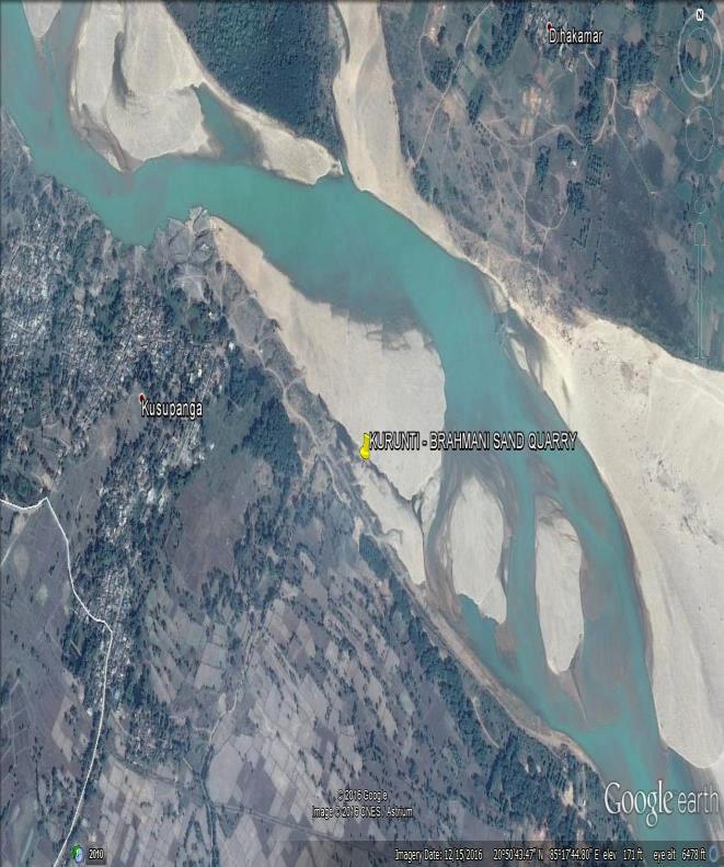
6 3. Location Map Of The Project 6
7 4. Geology Of The ML Area TOPOGRAPHY The project area is located in the Topo sheet no. 74/11 The quarry area bounded between the latitude of N to N and longitude of E to E. in The topo map showing the lease area is attached for reference. DRAINAGE The lease hold area lies in river bed of Ghorhaharh River. During rainy season & flood, mining activity cannot be take place. In the dry season the water bearing river width will be reduced and the sandy horizon of the lease hold area will be operated for excavation of sand. The bench slope and barrier zone will prevent the river water to flow into the mining area. 5. Regional Geology The sand bed is on the Ghorhaharh River. The Phasiguda Sand quarry deposit represents a gently sloping to almost flat terrain. The leae area belongs to recent quaternary river bed deposits consisting of sand,silt,gravel and alluvial deposit. The sand in the area is a weathering product of the nearby metamorphic Eastern Ghat rocks and has been transported by 1 st and 2 nd order nalas which ultimately gets deposited in the main nala/river bed during rainy seson. The sand in the Q.L. area is found to be ordinary sand which may be used for construction and road development purposes. 7
8 6. Mining Details The lease area is almost flat land covered with sand, during monsoon season due to heavy flow of water; sand dunes are formed within the lease area. Mining will be carried out at 77mRL in upper end and 76mRL in lower end upto an average depth of 0.5m at the end of the plan period. Open cast manual method of mining will be adopted during the mining operation within the plan period. The applicant has applied for wining of river sand from the lease area without drilling and blasting. There will not be any precise height and width during the mining of the sand. The sand will be loaded from the quarry by deploying labours and transport by hyvas. The generation of overburden is proposed to be nil. 8 nos. of man power will be deployed in the excavation of river sand. Mining activity shall be carried out for 300 days during October to June. It has been estimated that daily production of sand will be around 8 cum during the mining period. The river sand will be sold to the consumers directly so mineral processing will not be required. It will be utilized to fulfill the requirement in civil works like building and road construction. It is used for domestic purpose only & has no export use. Year plan of Financial year Surface area Thickness sand (m) ofvol. of sand of sand (M 3 ) in (m 3 ) 1 st nd rd th th Total
9 7. Environment Management Plan In order to minimize impacts of mining on environmental parameters and to maintain it within the prescribed limits of CPCB/SPCB, an Environment Management Plan (EMP) has been prepared. This will help in resolving all environmental and ecological issues likely to cause due to mining in the area. Environment Management Plan, which is to be implemented in the project has detailed under the following heads Land use pattern and river course environment Air Environment Water Environment Noise Environment Solid waste Management Soil Environment Biological Environment including Plantation Development Implementation of EMP and Monitoring Programme The Environmental management plan has been formulated for Phasiguda Sand Quarry over an area of Ha of Sri Kalu Charan Behera to mitigate the adverse impact of the river sand bed on Ghorhaharh river on the surrounding environment. This includes an environmental policy on protection of environment and public safety. The river management functions involve strategic planning, sustainable allocation of resources and environment compatible mining methods for protecting the health of the river system. Management of rivers includes legal, social and economic considerations, as well as scientific insights. TOPOGRAPHY, HYDROLOGY & LAND/ SOIL MANAGEMENT The major impact of the river bed sand mines on the land environment is due creation of access roads, mining operations, transportation of mined material. The study area itself being part of Ghorhaharh River course carries surface as well as ground water (under current). The flow of surface/ground water (sub surface flow) is following the trend of topography. The area is part of dry river bed for more than nine months in a year except for the rainy season. 9
10 The ground water table will be about 3 metres below the surface of river bed in the mining area during the dry seasons will not be disturbed as ultimate working depth is 0.5 m below the ground level. At the end of mining operations every yearly season, the flood waters would replenish the mined material. As per the mining plan there will be no waste generated due to sand mining. The impact assessment and proposed mitigation measure is as below Assessment Impact of Obstruction of river Flow Chang e in River slope / Morphology/ geometry and elevation. Change in land use pattern of the lease area Mitigation Measures The mining will be carried out in the dry areas of the river body in the non-monsoon seasons only. There will be no waste dumping in the lease area as the total mined out material will be sellable. The excavated sand will immediately transported out of the lease area. So that no dumping of the sand will be there in the river bed. So there is no change in The mining operation will be carried out in the lease area leaving the water cover area and the safety zone. The mining will be done only 0.5m below the surface level so that there will be no generation of deep pits in the lease area. There will be no mining activity in the river The land use pattern of the lease area belongs to Nadi Kisam and will remain a part of the active river course of Ghorhaharh River. The mining activity will be carried out in the active stream only during the dry season. So there will be no change in land use 10
11 In order to prevent the environmental degradation of leased mine area and its surroundings, the following measures shall be taken; There will be no creation of pits on the river bed. All the quarries developed during the excavation of the sand will be replenished in the monsoon season. Proper safety zone has been demarcated along the river bank and from the bridge. No mining activity will be carried out in the safety zone. No trees will be cut due to the proposed mining activity. The mining activity will be carried out during daylight only. There will be no stockpiling of excavated sand on the river bed or river bank. The excavated material will transport to the user agency as soon as possible. Water sprinkling on the transportation route as the river bed connecting to the highway is un-metalled road. There will be minimum numbers of access roads to river bed, as cutting river banks should be avoided and ramps are to be maintained. 11
12 8. Land Use Pattern and River Course Environment Land Use Pattern During the plan period the total mined out land will be Ha. The quantity of excavated sand in a year from the area in ideal condition, the same would be replenished during the subsequent flood/ rainy season Deviation from planned mining procedure can lead to bank erosion /cutting and thereby river channel shifting degradation of land, causing loss of properties and degradation of surrounding landscape. Thus for environment friendly river bed mining, the following control measures will be followed: Sand will be mined out in central position of lease area as per the mining plan. Access point to the river bed will be decided looking at the least steepness of river bank and least human activity. Number of access roads to river bed shall be provided minimum for which cutting of river banks will be avoided and ramps are to be maintained. The mining will remain confined to river bed only and in no case disturb any surface area outside which may affect topography or drainage. The mining from river bed does not have any impact on topography and natural drainage of surrounding area as no part of land outside river bed will be disturbed and the void formed due to excavated sand from river bed will be filled bank generally during monsoon season, more or less restoring to original position thus not affecting normal drainage in the river channel also. 12
13 9. Development of Green belt: As the lease area is a part of active river course, development of green belt within the lease area is not possible. There is the proposal for development of green belt along the road side, river bank and village waste land. Plantation programme for the mines has been given in table as below: Year Wise Progressive Green belt plan: Year Number of saplings proposed Saplings Location Total 250 Teak, Acasia Neem, Jamun Along the Approach roads & village roads, in schools and near public building, riverbank adjacent to the lease hold and other social forestry program. 13
14 AIR POLLUTION CONTROL MEASURES The excavation of the sand from Phasiguda sand quarry is a manual process. The only source of air pollution is due to the loading and transportation activity by trucks and tractors. The proposed mining operations are not anticipated to raise the concentration of the pollutants beyond prescribed limits. However, the following measures would be adopted to mitigate the incremental load of particulate matter in ambient air. Water sprinkling will be done for dust suppression on the unpaved road. Leveling of roads connecting the sand source will be done to maintain the uniform speed of the trucks/tippers. The vehicles will be maintained properly and at regular intervals to control the air emissions. The transporting trucks will be covered by tarpaulin so that dust emission will be reduced. Overloading will be avoided during the transportation. Dust mask provided to the workers engaged at dust generation points like excavations, loading and unloading points. The route for sand transportation of the area has been made outside the human habitation. Control of Gaseous Pollution The project area is for excavation of sand from the river bed. The only source of gaseous pollution is movement of vehicle. The mining process includes only manual mining without any emission of gaseous pollutants. This project includes movement of only 4 tractors will be used for transportation of sand from the lease area. So the gaseous pollution due to the present mining is very less. Control of Dust Pollution The dust emission will be there during excavation of sand, loading and transportation of sand. The measures taken of dust pollution control are as below: 14
15 The mines road will be properly maintained i.e. compacted, levelled for movement of trucks and tractors. The sand carrying trucks will be properly covered to reduce dust emission during the movement of trucks. Overloading of the trucks will be avoided. All the haulage road including the main ramp from the river will be kept wide, levelled, compacted and properly maintained and maintained regularly to prevent dust emission. NOISE AND VIBRATION ENVIRONMENT The sand excavation process does not involve any heavy earth moving machinery, so there will not be any major impact on noise level. There will be no drilling and blasting used for sand lifting, hence no possibility of land vibration. It was found that the proposed mining activity will not have any significant impact on the noise environment of the region. The only impact will be due to transportation of sand by trucks and tractor trolleys. Though the source of noise is very less following mitigation measures will be undertaken to maintain the noise level well within the limit: Minimum use of horns and speed limit of 10 kms in the village area. Timely maintenance of vehicles and their silencers to minimize vibration and sound. Provision of green belts in consultation with village panchayat near the river bank. Care will be taken to produce minimum sound during sand loading and movement of transporting vehicles. Earmuffs will be provided to the workers working in the noisy areas. 15
16 WATER MANAGEMENT Surface Water Management As the proposed excavation of sand mining is only manual and no waste water will be generated due to mining activity. During the sand excavation there is the possibility of increase in turbidity in surface water pollution due to the excavation of sand. Utmost care will be taken to minimize spillage of sand. The shallow depth excavation on dry/nominally wet sand close to the bank or dry river bed has been proposed, which will have negligible or no impact on drainage. Abandoned stream channels on terrace and inactive flood plains have been preferred rather than active channels and floodplains. Water that might percolate (if any) into excavation area has to be pumped out to channelize to river course during excavation. Stream will not be diverted to form inactive channel. Mining below subterranean water level will be avoided as a safeguard against any water contamination. Excavation at the concave side of river bank/ channel has been avoided to prevent bank erosion. Following environmental management plan will be undertaken to minimize the surface water pollution: The washing of trucks and tractor trolleys in the river will be completely avoided. Plantation along the river banks will undertake on degraded Panchayat waste land to improve its quality and utility. Monitoring of the surface water quality in both upstream and downstream of both the lease area will be carried out on quarterly basis to assess the impact of mining on River Bed. (Ghorhaharh river). Ground water Management It is observed from the dug well in the adjacent plain area and in the nearby villages that the ground water table varies between 4m to 14 m from the surface level depending upon seasonal variations. During dry season the water table falls to 14m from the surface whereas during rainy season the water table remains at 4m from the surface. As the mining activities presently proposed are maximum up to 1m that to within the river course and the total mining operation will be achieved through manual means, so there will be no effect on ground water table. 16
17 Table: Environmental Parameter and Frequency S.No. Potential Impact Parameters for Monitoring Frequency Monitoring of Location 1 Air Emission PM10, PM2.5, SO2, NOX & CO As per CPCB / MoEF & CC requirement i.e. 24 hourly monitoring for one month in each season except monsoon season. Two locations in the core mining area and four in buffer area. 2 Noise Spot Noise level recording Leq (day), Leq (night), Leq (dn) Periodic / As per CPCB norms i.e. Once in season (1- hourly) Two locations in the core mining area and four in buffer area. 3 Water Quality As per drinking water standards Once in a season except monsoon. Two locations in the core mining area and four in buffer area. 4 Soil Quality Analyzed as CPCB method Once in a season except monsoon. Two locations in core and two in the buffer area. 4 Health Total health parameters Initial Medical Examination (IME) and Periodic Medical Examination Once in a five year as per Mines Rules, All employees 17
18 SOCIO-ECONOMIC ENVIRONMENT This project operation will provide livelihood to the poorest section of the society. The overall impact of riverbed mining of sand on the socio economics of the area shall be positive one, as not only it will generate employment opportunities for local population at mine site but also in associated activity i.e. for transportation of mined material, construction activities etc. It will also give a good boost to the general economy of the area by providing employment opportunity to the local people. The project will help in enhancement of social infrastructure of the area. EMP IMPLEMENTATION AND MONITORING A large part of the sampling and measurement activities will be concerned with long term monitoring aimed at providing an early warning of any desirable changes or trends in the natural environment that could be associated with mining and allied activities. This is essential to determine where the changes are a response to a cycle of climatic conditions or are due to the mining or allied activities.in particular, a monitoring strategy is required to ensure that all environmental resources, which may subjected to contamination, are kept under review. Monitoring of the individual elements of the environment is necessary. The details of environmental monitoring has been given in table below: FREQUENCY OF MONITORING DIFFERENT PARAMETERS: SL. NO DESCRIPTION OF PARAMETERS SCHEDULE AND DURATION OF MONITORING 1 Air Quality for PM10, SO2 and NOx, Once in a month Respirable dust a Ambient air quality around loading & unloading stations by installing 4 stations (one in core zone and 3 in buffer zone) 2 Water quality analysis Once per season a Ground water & surface water samples 3 Noise level Once a season during the 1st a At lease hold area & residential area year, 4 Ocupational health check up Once in a year 18
19 DETAILED BUDGET OF ENVIRONMENTAL MANAGEMENT PLAN Lessees will be ultimately responsible for ensuring clean environment in and around the quarries. To evaluate the effectiveness of environmental management programme, regular monitoring of the important environment protection activities will be taken up. A budget of rs 90,000 for implementation of EMP shall be assigned for the purpose. The details break up cost for implementing the environmental protection measures is given below: Sl. No Particulars Capital Cost in RS 1 Environmental monitoring(ambient air quality monitoring pm10 and pm2.5 so2, nox and co & other parameters as per regulatory norms) 30,000 2 Water sprinkling,plantation and maintenance 20,000 3 CSR activities 10,000 4 Miscellaneous activities 10,000 Total Capital Cost 70,000 Recurring cost 20,000 19
20 Conclusion Post Project Environmental monitoring is an essential tool in Environmental Management Program to check Environmental Quality status through monitoring of Environmental parameters as per frequency and method recommended by CPCB. It helps environmental planners, policy makers, managements, scientists and technologists to make amendment at the appropriate placers for clean technology and green environment. Mitigation measures are applied at the various stages; fuel, technology and housekeeping and waste management. Mitigation may be in form of technology up-gradation, design modification or modification in environmental policy. Environment works on cause -and -effect relationship. Clean technology will provide green environment. Clean mining activity will be required for sustainable growth. The Environmental Monitoring Cell will co-ordinate all monitoring program, environmental awareness program, training and its importance in proposed project at site. Data generated will be furnished as per statutory requirements in CTE/CTO and the environmental conditions. The frequency of monitoring will be one month in each season except monsoon. Half yearly report will be submitted on June and January of each year to the Regional Office of MoEF &CC, Odhisa. The Environmental audit reports will be prepared for the entire year of operations and will be regularly submitted to regulatory authorities. Objective of entire process will be to improve environment and reduce the impact of project / project activities on environment. 20