Missouri River Basin Water Management
|
|
|
- Maude Barrett
- 5 years ago
- Views:
Transcription


1 Missouri River Basin Water Management US Army Corps of Engineers Low Water Update November 20, 2012 Jody Farhat, P.E. Chief, Missouri River Basin Water Management US Army Corps of Engineers
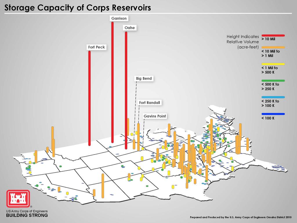
2 Missouri River Mainstem Reservoir System Fort Peck Montana Garrison South Dakota Oahe North Dakota Big Bend Wyoming Fort Randall Gavins Point Nebraska Iowa Colorado Kansas Missouri 2
3 4


4 Our Mission Regulate Missouri River Mainstem Reservoirs to Support Congressionally Authorized Purposes Flood Control Hydropower Water Supply Water Quality Control Navigation Fish and Wildlife Including Threatened and Endangered Species Irrigation Recreation 4
5 5

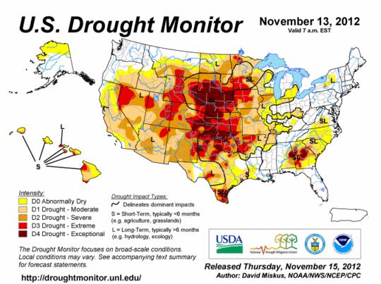
6 Graphics courtesy of Natiol Drought Mitigation Center
7 Missouri River Mainstem System Annual Runoff above Sioux City, IA 70 Million Acre-Feet Historic Drought Periods U.D. 10% 30 U.Q. Median 25% 50% L.Q. L.D. 75% 90%
8 Missouri River Mainstem System Storage Zones and Allocations Exclusive Flood Control 6% Annual Flood Control & Multiple Use 16% Historic max Storage In MAF Carryover Multiple Use 53% Nov 19, 2012 Mar 1, 2013 Historic min Permanent Pool 25%
9 Current Reservoir Levels November 19, 2012 Fort Peck Exclusive Flood Control Annual Flood Control & Multiple Use Exclusive Flood Control Annual Flood Control & Multiple Use Elevation in feet msl Garrison Elevation in feet msl Carryover Multiple Use Carryover Multiple Use Exclusive Flood Control Annual Flood Control & Multiple Use Carryover Multiple Use Permanent Pool 5.0 feet below base of Flood Control zone Oahe Elevation in feet msl Exclusive Flood Control Annual Flood Control & Multiple Use Permanent Pool 6.5 feet below base of Flood Control zone Fort Randall Carryover Multiple Use Elevation in feet msl Permanent Pool 13.5 feet below base of Flood Control zone Permanent Pool 11.0 feet below base of Flood Control zone
10 Missouri River Navigation Support Navigation support provided by meeting target flows at four locations: Sioux City, Omaha, Nebraska City, and Kansas City Level of service based on Reservoir System Storage checks on March 15 and July 1 Navigation Flow Support Full Service: flows designed to support a 9x300 ft channel Minimum Service: 6,000 cfs less than full service Flows designed to support a 8x200 ft channel Navigation Season Length Full Length Season: 8 month season from April 1 to December 1 at the mouth Reduced Season Length: 6 to 8 months during droughts Extended Season Length: 8 months + 10 days for flood water evacuation 10
11 2012 Navigation Support Based on July 1, 2012 System Storage check Full service flow support & full length season Flows to support 9x300 ft channel Eight month season from April 1 to December 1 Releases will be stepped down at approximately 3,000 cfs per day beginning on November 23 11
12 2012 Navigation Season Last Day of Flow Support Sioux City (31,000 cfs) November 22 Omaha (31,000 cfs) November 24 Nebraska City (37,000 cfs) November 25 Kansas City (41,000 cfs) November 27 Mouth near St. Louis December 1 12
13 Missouri River Winter Releases Gavins Point winter releases based on September 1 System Storage check Normal winter releases = 17,000 cfs Minimum winter releases = 12,000 cfs 2012 winter releases = 12,000 cfs due to drought Meet needs of downstream water intakes on the Missouri River to the extent reasonably possible Channel changes since the flood may require releases in excess of 12,000 cfs 13
14 50 Missouri River Flows November December Flow in 1000 cfs Nov-12 Nov-12 Nov-12 Nov-12 Dec-12 Dec-12 Dec-12 Dec-12 Dec-12 Gavins Point Release Hermann, Missouri 14
15 2013 Navigation Support March 15, 2013 Storage Check Near minimum service flow support July 1, 2013 Storage Check Upper Decile: full service, full season + 10 days Median: near full service, full season Lower Decile: 5 kcfs below full service, 2-day season shortening 15
16 Missouri Basin Drought Impacts Full navigation season / full service flows in 2012 Drought in lower basin required higher than normal releases to meet navigation targets resulting in quicker than normal drawdown of reservoirs Low tributary inflow contributing to navigation challenges on lower Missouri River Concerns about Mississippi River navigation after Missouri River flow support ends in early December Gavins Point winter releases at minimum level ~ 12,000 cfs Concern over operability of municipal and industrial water intakes due to changed river conditions Upper three reservoirs 5 to 14 feet below the top of conservation pool Tribes concerned about exposure of cultural resources with low reservoir levels Boat ramp issues
17 Missouri Basin Drought Impacts Reduced navigation support At or near minimum service flow support at start of navigation season Potential for reduced season based on July 1 storage check Further reductions in navigation support if drought continues Reservoir system begins runoff season 8 MAF below the top of the conservation (carry-over multiple use) zone Upper three reservoirs begin runoff season 10 to 12 feet below normal Tribes concerned about exposure of cultural resources with low reservoir levels Boat ramp issues impact on recreation visitation at reservoirs Reduced hydropower generation Concern about impact to reservoir fisheries Concern about municipal and industrial water intakes on reservoirs if drought continues Gavins Point releases at minimum level next winter
18 Annual Operating Plan Schedule Draft Annual Operating Plan developed using August 1 starting condition Based on 5 statistical runoff scenarios September 5, 2012 letter to Tribes offered consultation Draft AOP released in late September 2012 Public meetings held the week of October 29, 2012 Comments due November 23, 2012 Final Annual Operating Plan in December 2012
19 Thank You! Jody Farhat, P.E Or Google Corps Missouri River 19