INTERCHANGE IMPROVEMENTS S T A T E P R O J E C T : , P ; U P C
|
|
|
- Helen Tyler
- 5 years ago
- Views:
Transcription
1 V I R G I N I A D E P A R T M E N T O F T R A N S P O R T A T I O N F A I R F A X C O U N T Y P A R K W A Y INTERCHANGE IMPROVEMENTS S T A T E P R O J E C T : , P ; U P C F I N A L R E P O R T A I R Q U A L I T Y T E C H N I C A L S T U D Y Interchanges of Fairfax County Parkway (Route 286) with Interstate 95 & Rolling Road (Route 638)/Franconia-Springfield Parkway (Route 289) Fairfax County, Virginia Prepared for: Virginia Depar tment of Transpor tation Environmental Division 1401 East Broad Street Richmond, VA A P R I L
2 Virginia Department of Transportation Fairfax County Parkway Interchange Improvements Project State Project: , P101; UPC Interchanges of Fairfax County Parkway (Route 286) with Interstate 95 & Rolling Road (Route 638) / Franconia-Springfield Parkway (Route 289) Fairfax County, Virginia FINAL REPORT - AIR QUALITY TECHNICAL STUDY Virginia Department of Transportation Environmental Division 1401 East Broad Street Richmond, Virginia April 2012
3 Table of Contents I. Introduction... 1 II. Project Description / Alternatives... 1 Figure 1 Regional Location Map... 2 III. Existing Conditions... 4 Figure 2A Project Location Map I-95/Fairfax County Parkway Interchange Option Figure 2B Project Location Map I-95/Fairfax County Parkway Interchange Option Figure 3 Project Location Map Rolling Road/Franconia-Springfield Parkway Interchange... 7 IV. Regulations / Criteria... 8 Table 1 National Ambient Air Quality Standards... 9 Table 2 Fairfax County Parkway Interchange Improvements AADT Summary V. Carbon Monoxide Analysis Table 3 Inputs to MOBILE Table 4 CAL3QHC Worst Case Inputs Table 5 MOBILE6.2 Outputs - Summary of CO Emission Rates Table 6 Sensitive Receptor Locations Selected for Carbon Monoxide Analysis Table 7 Fairfax County Parkway / I-95 Interchange Location CO Analysis Table 8 Rolling Road / Franconia-Springfield Parkway Interchange Location CO Analysis VI. Fine Particulate Matter Analysis VII. Mobile Source Air Toxics (MSAT) VIII. Construction Impacts IX. Conformity Status of the Project X. Conclusion Appendices Appendix A Mobile Input / Output Files Appendix B CAL3QHC Input / Output Files Appendix C Traffic Summary / SYNCHRO Reports Appendix D References Appendix E List of Preparers/Reviewers
4 I. Introduction Air quality became a national concern in the mid-1960s, leading to the passage of the Air Quality Act in Following the passage of the Federal Clean Air Act Amendments of 1990 (CAAA), states were mandated to implement additional steps to reduce airborne pollutants and improve local and regional conditions. Automobile emissions have been identified as a critical element in attaining federal air quality standards for carbon monoxide (CO) and ozone (O 3 ). As a result of federal funding for this project, compliance is required with both the National Environmental Policy Act (NEPA) and the U.S. Environmental Protection Agency (EPA) Transportation Conformity Rule. Highway agencies are required to consider the impacts of transportation improvement projects on both the local and regional level. Regional air quality, when located in ozone nonattainment and maintenance areas, is assessed by ensuring that region-wide volatile organic compounds (VOC) and nitrogen oxide (NOx) emissions fall below the established motor vehicle emission budgets identified by the State Implementation Plan (SIP). When applicable, this assessment is performed by the Virginia Department of Transportation (VDOT) and / or regional planning commissions and documented in the Transportation Improvement Program (TIP) and Long Range Transportation Plan (LRTP). The project lies within the VA-DC-MD 8-hour ozone and fine particulate matter (PM 2.5 ) nonattainment area; therefore, conformity requirements apply. Generally, local air quality is assessed on a micro-scale by evaluating CO concentrations at the project level. CO is a colorless, odorless, poisonous gas considered to be a serious threat to those who suffer from cardiovascular disease. High concentrations of CO tend to occur in areas of high traffic volumes or areas adjacent to a stationary source of the pollutant. CO emissions are associated with the incomplete combustion of fossil fuels in motor vehicles and are considered to be a good indicator of vehicle-induced air pollution. As published in a VDOT news release (NR12-17) on February 16, 2012, the Fairfax County Parkway (Route 7100), which runs from Route 1 to Route 7, will be renamed Route 286. In addition, the Franconia-Springfield Parkway (Route 7900), which runs from Beulah Road to the Fairfax County Parkway, will be renamed Route 289. Over the course of the next three months, VDOT will replace sings with the new route numbers along each corridor. For consistency with this VDOT news release, both roadways will be referred to as Route 286 and Route 289 throughout the remainder of this report. II. Project Description / Alternatives Project Study Area The Virginia Department of Transportation (VDOT), in cooperation with the Federal Highway Administration (FHWA), is studying improvements to two existing interchanges on the Fairfax County Parkway (Route 286). The first involves constructing a new flyover ramp at the Interstate 95 (I-95) interchange (Exit 166) for traffic moving from northbound I-95 to westbound Fairfax County Parkway. That movement currently is made using a loop ramp in the northeast quadrant of the interchange. The second Fairfax County Parkway Interchange Improvements Final Report Air Quality Technical Study 1 Fairfax County, VA
5 involves expanding the existing single-lane loop ramp in the northeast quadrant of the Rolling Road/Franconia-Springfield Parkway/Fairfax County Parkway interchange, which carries traffic from northbound and southbound Rolling Road to westbound Fairfax County Parkway to two lanes. With the recent completion of the section of Fairfax County Parkway through the U.S. Army s Fort Belvoir North Area (formerly known as Engineer Proving Ground), northbound traffic on that facility will use the expanded ramp to access westbound Fairfax County Parkway. Figure 1 shows the location of the project. The study area consists of lands surrounding these two proposed project elements on which there are human activities that could potentially be affected by the project. ALTERNATIVES: No-build Alternative Under the No-build Alternative, no improvements to the subject interchange ramps would be implemented. For this alternative, the existing transportation system plus all other projects funded for construction in the National Capital Region's Financially Constrained Long Range Transportation Plan (CLRP) are assumed to be in place. Thus, the following projects are assumed to have been constructed by the design year of 2040: I-95/I-395 HOV/Bus/HOT Lanes Project. Construct a third lane along existing two high occupancy vehicle (HOV) lanes and convert HOV lanes to HOV/Bus/HOT (high occupancy toll) lanes. The limits of each of the three improvement areas are identified below: o Widen existing I-95 HOV lanes from two to three lanes across 14 miles between the Prince William Parkway to approximately two miles north of the Springfield Interchange in the vicinity of Edsall Road. o Make improvements to the existing two HOV lanes for six miles from Route 234 to the Prince William Parkway. o Extend a two-lane 9-mile extension of the existing HOV lanes from Dumfries to Garrisonville Road in Stafford County. Defense Access Roads (DAR) Ramps. Construct a new access ramp from I-95 to the Fort Belvoir North Area. The proposed project would include a new connection between Heller Road on the eastern side of the Fort Belvoir North Area and the existing flyover bridge that connects the HOV lanes with the northbound I-95 general-purpose lanes. Fairfax County Parkway/Franconia-Springfield Parkway High Occupancy Vehicle (HOV) Lanes. Construct a single HOV lane in each direction between Sydenstricker Road (Route 640) and Frontier Drive (which is east of I-95 at the Franconia-Springfield Metro Station, the southernmost stop on the Washington Metropolitan Area Transit Authority s regional rail system). Rolling Road Widening. Widen existing road from two to four lanes from Fairfax County Parkway northward to Old Keene Mill Road (Route 644). Fairfax County Parkway Interchange Improvements Final Report Air Quality Technical Study 2 Fairfax County, VA

6 Rol North Springfield Lake Accotink Park West Springfield Springfield Golf and Country Club Springfield Fairfax County Parkway & Project Location Hooes Road Park F a i r f a x C o u n t y UV7900 & Franconia-Springfield Parkway 95 Hilltop Golf Club Franconia ling Road Newington Lorton Davison Army Airfield Davison Army Airfield 1 Fort Belvoir US Army Res Fort Belvoir Figure 1 Regional Location Map Fairfax County Parkway Interchange Improvements Project / Fairfax County, Virginia Mile Fairfax County Parkway Interchange Improvements Final Report Air Quality Technical Study Fairfax County, VA 3
7 Proposed Build Alternatives The proposed build alternatives are approximately two miles apart in Fairfax County, Virginia. The improvement at the Fairfax County Parkway (Route 286) and I-95 (Exit 166) interchange consists of a single-lane flyover ramp to carry traffic exiting northbound I-95 to go west on Fairfax County Parkway. The diverge point for this ramp and diverge point for the existing I-95-to-eastbound-Fairfax County Parkway would be combined into a single diverge point to facilitate getting traffic off I-95 and to avoid introducing an additional diverge point. A single diverge point for the Fairfax County Parkway westbound and eastbound off-ramps is the preferred solution to minimize impacts on the I-95 mainline traffic flow. The conceptual design would preclude traffic on the flyover ramp from accessing Backlick Road or the future Boudinot Drive interchange. This is to avoid conflicts with traffic entering Fairfax County Parkway from the right and weaving movements at the Boudinot Drive interchange. To provide for the Backlick Road and Boudinot Drive interchange access, two design options are being considered: Option 1. The first option would involve leaving the existing loop ramp open so that I-95 northbound traffic could continue to reach northbound Backlick Road and also access the future Boudinot Drive interchange, as shown on Figure 2A. Option 2. The second option would involve eliminating the existing loop ramp and constructing left-turn lanes at the terminus of the existing ramp from I-95 northbound to eastbound Fairfax County Parkway and Loisdale Road. Left turns are not currently permitted at this intersection. Option 2 can be referenced on Figure 2B. The second improvement is located approximately two miles northwest at the Rolling Road (Route 638) / Franconia-Springfield Parkway (Route 289) interchange and consists of the widening of the inside loop ramp from one to two lanes and minor improvements to the Fairfax County Parkway, as shown in Figure 3. III. Existing Conditions The proposed project is located in northern Virginia in Fairfax County. The area is best categorized as a humid subtropical climate that averages approximately 43 inches of precipitation per year. The average daily high temperature in July is 90 degrees Fahrenheit while the average daily low temperature in January is 23 degrees Fahrenheit. Traffic Summary Information Traffic forecasts were revised for the project for Existing (2011), Interim/Opening Year No-Build (2020), Interim/Opening Year Build (2020), Design Year No-Build (2040), and Design Year Build (2040) conditions for both interchange locations. The traffic operations for the network were evaluated using SYNCHRO and VISSIM and volumes were adjusted based on actual operating conditions of the intersection. The traffic volumes used in the CO analysis are based on the preliminary AM and PM peak traffic volume projections used by the Project Team and as presented in the SYNCHRO reports. Fairfax County Parkway Interchange Improvements Final Report Air Quality Technical Study 4 Fairfax County, VA
8 95 Alban Rd Haute Ct Fullerton Rd Dr Boudinot Alban Rd Terminal Rd 1O 1P 1Q Fairfax County Parkway (Route 286) 1R 1A 1B 1C 1D 1E 1F 1K 1J 1G 1L 1I 1H 1M 1N Loisdale Rd MT HB 5 21, :47:07 AM + Air Quality Receptor Proposed New Alignment Feet Meters. UV600 West Springfield Burke Lorton Springfield 95 Newington Franconia Fort Belvoir Fort Belvoir US Army Reservation Mount Vernon WV Virginia NC 95 PA MD DE Fairfax County Parkway Interchange Improvements I-95 / Fairfax County Parkway Interchange - Option 1 State Project: , P101; UPC Virginia Department of Transportation Figure 2A Fairfax County, Virginia Aerial Source: VBMP 2011 Preliminary Imagery AERIAL IMAGERY COPYRIGHT 2011 COMMONWEALTH OF VIRGINIA Fairfax County Parkway Interchange Improvements Final Report Air Quality Technical Study 5 Fairfax County, VA
9 95 Alban Rd Haute Ct Fullerton Rd Dr Boudinot Alban Rd Terminal Rd 1O 1P 1Q Fairfax County Parkway (Route 286) 1R 1A 1B 1C 1D 1E 1F 1K 1J 1G 1L 1I 1H 1M 1N Loisdale Rd MT HB 5 21, :47:07 AM + Air Quality Receptor Proposed New Alignment Feet Meters. UV600 West Springfield Burke Lorton Springfield 95 Newington Franconia Fort Belvoir Fort Belvoir US Army Reservation Mount Vernon WV Virginia NC 95 PA MD DE Fairfax County Parkway Interchange Improvements I-95 / Fairfax County Parkway Interchange - Option 2 State Project: , P101; UPC Virginia Department of Transportation Figure 2B Fairfax County, Virginia Aerial Source: VBMP 2011 Preliminary Imagery AERIAL IMAGERY COPYRIGHT 2011 COMMONWEALTH OF VIRGINIA Fairfax County Parkway Interchange Improvements Final Report Air Quality Technical Study 6 Fairfax County, VA
 2H Hooes Rd White House Dr Fairfax County Parkway (Route 286) Camp David Dr Walnut Knoll Dr Rolling Rd Rolling Rd Rolling Rd Hooes Rd Hooes Rd Cyril Pl Barkers Ct Rose")

10 Rolling Joshua Tree La Forest Av Ming Tree Ct Hunter Carnation Ct Wentworth Pl Village Dr Flax St 2I 2J 2K Gerardia Ct 2A 2B 2C Rolling Rd 2D Spring Forest Ct 2E 2F 2G Rolling Rd Franconia Springfield Parkway (Route 289) 2H Hooes Rd White House Dr Fairfax County Parkway (Route 286) Camp David Dr Walnut Knoll Dr Rolling Rd Rolling Rd Rolling Rd Hooes Rd Hooes Rd Cyril Pl Barkers Ct Rose Garden La MT HB 5 21, :47:07 AM + Air Quality Receptor Proposed New Alignment Feet Meters. UV600 West Springfield Burke Lorton Springfield 95 Newington Franconia Fort Belvoir Fort Belvoir US Army Reservation Mount Vernon WV Virginia NC 95 PA MD DE Fairfax County Parkway Interchange Improvements Rolling Road / Franconia - Springfield Parkway Interchange State Project: , P101; UPC Virginia Department of Transportation Figure 3 Fairfax County, Virginia Aerial Source: VBMP 2011 Preliminary Imagery AERIAL IMAGERY COPYRIGHT 2011 COMMONWEALTH OF VIRGINIA Fairfax County Parkway Interchange Improvements Final Report Air Quality Technical Study 7 Fairfax County, VA
11 IV. Regulations / Criteria Under the National Environmental Policy Act (NEPA), federal agencies must consider environmental factors in the decision-making process. Changes in air quality, and the effects of such changes on human health and welfare, are among the factors to be considered. A project-level air quality analysis has been performed to assess the air quality impacts of the project, document the findings of the analysis, and make the findings available for review by the public and decisionmakers. The findings of the analysis, as presented in this report, are summarized in the NEPA documentation. As implemented by the Clean Air Act, the EPA is required to set the National Ambient Air Quality Standards (NAAQS) for pollutants considered harmful to public health and welfare. As shown in Table 1, there are currently two standards: Primary Standards to protect public heath and Secondary Standards to protect the public welfare (e.g., to protect against damage to crops, vegetation, buildings, and animals). Federal actions must not cause or contribute to any new violation of any standard, increase the frequency or severity of any existing violation, or delay timely attainment of any standard or required interim milestone. Geographic regions that do not meet NAAQS for one or more criteria pollutants are designated by EPA as nonattainment areas. Areas previously designated as nonattainment, but subsequently re-designated attainment because they no longer violate NAAQS, are designated as maintenance areas subject to maintenance plans to be developed and included in a state s SIP. The project is located in Fairfax County and lies within the 8-hour ozone and fine particulate matter (PM 2.5 ) nonattainment areas, which includes portions of Northern Virginia, Southern Maryland, and the District of Columbia. The federal conformity rule (40 CFR Parts 51 and 93) requires air quality conformity determinations for transportation plans, programs, and projects in non-attainment or maintenance areas for transportation-related criteria pollutants for which the area is designated nonattainment or has a maintenance plan (40 CFR (b)). Transportation-related criteria pollutants, as specified in the conformity rule, include ozone (O 3 ), carbon monoxide (CO), nitrogen dioxide (NO 2 ), and particulate matter less than 10 and 2.5 microns in diameter (PM 10 and PM 2.5, respectively). Regional conformity analysis requirements apply for plans and programs; hot-spot analysis requirements of 40 CFR and apply for projects. Modeling protocols for quantitative hot-spot analyses are to comply with the standards outlined in 40 CFR 51, Appendix W, Guideline on Air Quality Models, and guidelines in EPA s Guideline for Modeling Carbon Monoxide from Roadway Intersections (EPA- 454/R ). EPA and FHWA issued joint guidance for conducting hot-spot analyses for particulate matter: Transportation Conformity Guidance for Qualitative Hot-Spot Analyses in PM 2.5 and PM 10 Nonattainment and Maintenance Areas (March 2006). Based on the guidance, the proposed project is not considered a project of air quality concern, and, as such, is exempt from a qualitative assessment of PM 2.5. A detailed discussion can be found in Section VI of this report. Fairfax County Parkway Interchange Improvements Final Report Air Quality Technical Study 8 Fairfax County, VA
12 Table 1 National Ambient Air Quality Standards Primary Standards Secondary Standards Pollutant Level Averaging Time Level Averaging Time Carbon Monoxide Lead Nitrogen Dioxide Particulate Matter (PM 10 ) Particulate Matter (PM 2.5 ) Ozone Sulfur Dioxide 9 ppm (10 mg/m 3 ) 8-hour (1) None 35 ppm 1-hour (1) (40 mg/m 3 ) 0.15 µg/m 3 (2) Rolling 3-Month Same as Primary Average 1.5 µg/m 3 Quarterly Average Same as Primary ppm (100 µg/m 3 ) Annual (Arithmetic Mean) Same as Primary 150 µg/m 3 24-hour (3) Same as Primary 15.0 µg/m 3 Annual (4) (Arithmetic Mean) Same as Primary 35 µg/m 3 24-hour (5) Same as Primary ppm (2008 std) 8-hour (6) Same as Primary 0.08 ppm (1997 std) 8-hour (7) Same as Primary 0.12 ppm 1-hour (8) Same as Primary 0.03 ppm Annual 3-hour (1) (Arithmetic Mean) 0.14 ppm 24-hour (1) 0.5 ppm (1300 µg/m 3 ) (1) Not to be exceeded more than once per year. (2) Final rule signed October 15, (3) Not to be exceeded more than once per year on average over 3 years. (4) To attain this standard, the 3-year average of the weighted annual mean PM 2.5 concentrations from single or multiple community-oriented monitors must not exceed 15.0 µg/m 3. (5) To attain this standard, the 3-year average of the 98th percentile of 24-hour concentrations at each population-oriented monitor within an area must not exceed 35 µg/m 3 (effective December 17, 2006). (6) To attain this standard, the 3-year average of the fourth-highest daily maximum 8-hour average ozone concentration measured at each monitor within an area over each year must not exceed ppm. (effective May 27, 2008) (7) (a) To attain this standard, the 3-year average of the fourth-highest daily maximum 8- hour average ozone concentration measured at each monitor within an area over each year must not exceed 0.08 ppm. (b) The 1997 standard and the implementation rules for that standard will remain in place for implementation purposes as EPA undertakes rulemaking to address the transition from the 1997 ozone standard to the 2008 ozone standard. (8) (a) The standard is attained when the expected number of days per calendar year with maximum hourly average concentrations above 0.12 ppm is < 1. (b) As of June 15, 2005 EPA has revoked the 1-hour ozone standard in all areas except the fourteen 8-hour ozone nonattainment Early Action Compact (EAC) Areas. For one of the 14 EAC areas (Denver, CO), the 1-hour standard was revoked on November 20, For the other 13 EAC areas, the 1-hour standard was revoked on April 15, Source: Table and footnotes above are excerpted from US Environmental Protection Agency website: Fairfax County Parkway Interchange Improvements Final Report Air Quality Technical Study 9 Fairfax County, VA
13 As indicated in the Consultant Guide, on February 27, 2009, FHWA and VDOT completed the updated Memorandum of Understanding (MOU) addressing requirements on when a quantitative or qualitative CO hot-spot analysis is required. Under this revised agreement (original agreement was August 4, 2004), project-level air quality (hot-spot) analyses are conducted for CO for projects that meet traffic and related criteria as specified in the revised agreement. In the original air study completed in March 2010, Average Annual Daily Traffic (AADT) volumes exceeded 59,000 at both interchange locations. However, as part of the project s reevaluation, regional traffic models were revised to include a decline in recent growth trends as well as to project Design Year 2040 volumes. As shown in Table 2, Average Annual Daily Traffic (AADT) Summary, traffic volumes no longer exceed 59,000 AADT at either interchange location. Although not required in the agreement, a quantitative CO analysis was performed as part of the detailed air quality study to remain consistent with the March 2010 assessment. FHWA issued on September 30, 2009 updated guidance titled Interim Guidance Update on Mobile Source Air Toxic Analysis in NEPA Documents. The guidance included specific criteria for determining which projects are to be considered exempt from MSAT analysis requirements and which may require a qualitative or quantitative analysis. Projects considered exempt under section 40 CFR of the federal conformity rule are also specifically designated as exempt from MSAT analysis requirements. This project does not create new capacity or add significant capacity to urban highways, such as interstates, urban arterials, or urban collector-distributor routes with forecasted design year average annual daily traffic volumes in the range of 140,000 to 150,000 or greater, and which are also in proximity to populated areas. Furthermore, this project will not result in any meaningful changes in traffic volumes or vehicle mix or changes relative to the No-Build (2040) condition and is therefore, considered exempt from an analysis. The updated guidance reflects recent regulatory changes, projects national MSAT emission trends out to 2050, and summarizes recent research efforts; however, it does not change any project analysis thresholds, recommendations, or guidelines. VDOT s May 2009 Consultant Guide, Air Quality Project-Level Analysis, Revision 18, provides guidelines and standards for conducting air quality analyses for transportation projects in Virginia. The guide complies with and supplements FHWA and EPA regulations and guidelines. The air quality analyses presented in this report are consistent with the guide. In 2009, the EPA released a new model called the Motor Vehicle Emissions Simulator (MOVES). This model will replace MOBILE6.2 for estimating on-road motor vehicle emissions. In March of 2010, the EPA published a Federal register notice of availability that approved MOVES2010 as the EPA s tool for estimating emissions of volatile organic compounds (VOCs), nitrogen oxide (NOx), CO, PM 10, PM 2.5, and other pollutants. This approval started the beginning of the two-year grace period before MOVES2010 is required for use in transportation conformity analysis. In August of 2010, EPA approved the latest version of the MOVES model (MOVES2010a) for official use. It incorporates new car and light truck greenhouse gas emission standards that were published May 2, 2010 as well as a number of other minor improvements. Fairfax County Parkway Interchange Improvements Final Report Air Quality Technical Study 10 Fairfax County, VA
14 Table 2 Fairfax County Parkway Interchange Improvements Average Annual Daily Traffic (AADT) Summary Road Segment Existing (2011) ADT Interim/Opening Year No-Build (2020) ADT Interim/Opening Year Build (2020) ADT (Option 1) Interim/Opening Year Build (2020) ADT (Option 2) Design Year No- Build (2040) ADT Design Year Build (2040) ADT (Option 1) Design Year Build (2040) ADT (Option 2) New Flyover Ramp n/a 0 0 4,500 4, ,800 5,800 Existing I-95 NB Loop Off-Ramp to Backlick Rd/Fullerton Rd Existing Exit 166B 8,400 5,600 5, ,200 7,200 0 Existing I-95 NB Off-Ramp to Fairfax County Parkway East/Ft Belvoir Existing Exit 166A 9,200 6,100 6,100 11,700 7,800 7,800 15,000 Fairfax County Parkway (Route 286) South of Loisdale Road 50,300 46,400 46,400 46,400 46,800 46,800 46,800 Fairfax County Parkway (Route 286) North --> I-95 NB On-Ramp n/a 11,600 9,900 9,900 9,900 9,500 9,500 9,500 Loisdale Road East of Fairfax County Parkway (Route 286) 14,600 15,000 15,000 15,000 16,200 16,200 16,200 Road Segment Existing (2011) ADT Interim/Opening Year No-Build (2020) ADT Interim/Opening Year Build (2020) Build ADT Design Year No- Build (2040) ADT Design Year Build (2040) ADT Rolling Road North of Fairfax County Parkway (Route 286) 29,000 30,400 30,400 32,200 32,200 Rolling Road South of Fairfax County Parkway (Route 286) 40,100 45,900 45,900 53,200 53,200 Fairfax County Parkway (Route 286) --> Rolling Road Off-Ramp n/a 5,800 9,200 9,200 12,000 12,000 Fairfax County Parkway (Route 286) West of Rolling Road 61,900 65,200 65,200 69,000 69,000 NOTE: Build "Option 1" involves keeping the existing I-95 North loop ramp. Build "Option 2" accounts for closure of existing I-95 North loop ramp. Fairfax County Parkway Interchange Improvements Final Report Air Quality Technical Study 11 Fairfax County, VA
15 On December 20, 2010, EPA released final guidance for conducting quantitative hot-spot analyses in PM 2.5 and PM 10 nonattainment and maintenance areas titled Transportation Conformity Guidance for Quantitative Hot-spot Analyses in PM 2.5 and PM 10 Nonattainment and Maintenance Areas, EPA-420-B After the grace period expires, the new guidance must be used by state and local agencies to conduct quantitative PM hot-spot analyses for new or expanded highway or transit projects with significant levels of diesel traffic that are located in PM 2.5 and PM 10 nonattainment and maintenance areas. However, it was determined that this project is considered not a project of air quality concern and as such, is exempt from a quantitative analysis and has met all requirements of the March 2006 Final Rule. Addition documentation can be referenced in Section VI of this report. Transportation Conformity Rule EPA promulgated the Transportation Conformity Rule concerning the applicability, procedures, and criteria that transportation agencies must use in analyzing and determining conformity of transportation projects. The Transportation Conformity Rule applies to federally-funded transportation projects in certain areas that have violated one or more of the NAAQS (non-attainment/maintenance areas). This project lies within the VA-DC-MD 8-hour ozone and fine particulate matter (PM 2.5 ) nonattainment area. The project is considered regionally significant and therefore the conformity requirements apply. The appropriate documentation can be referenced in Chapter IX of this report. V. Carbon Monoxide Analysis The purpose of this study is to identify worst-case carbon monoxide (CO) concentrations throughout the project corridor. The proposed improvements include the addition of a flyover ramp from I-95 northbound to the Fairfax County Parkway westbound and the widening of the existing loop ramp from one to two lanes at the Rolling Road / Franconia-Springfield Parkway interchange area. Existing (2011), Interim/Opening Year No-Build (2020), Interim/Opening Year Build (2020), Design Year No-Build (2040), and Design Year Build (2040) conditions will be analyzed to determine if air quality exceedences would occur as a result of the proposed improvements. CO is a stable gas that disperses in predictable ways in the atmosphere. Therefore, computer modeling can be used to assess both existing and expected future atmospheric concentrations of CO at selected receptor sites. The modeling inputs and procedures were developed in accordance with EPA s Guideline for Modeling Carbon Monoxide from Roadway Intersections and VDOT s May 2009 Consultant Guide, Air Quality Project-Level Analysis, Revision 18. The air quality modeling approach includes the use of two computer programs. Based on traffic data and historic climatic data, CO emissions are calculated using the EPA MOBILE6.2 computer model. In order to streamline this approach, FHWA s EMIT model was used to calculate CO emission rates at varying speeds for each analysis year. The projected worst-case CO emission rates are then applied to the CAL3QHC computer Fairfax County Parkway Interchange Improvements Final Report Air Quality Technical Study 12 Fairfax County, VA
16 model. This program is used to determine dispersion of CO from highway sources to air quality sensitive receptors by representing the geometric relationship between roadways and receptor sites. Factors taken into account in this model include pollutant source strength, wind speed, wind angle, atmospheric stability, roadway length and width, surface roughness, vehicle volume, emission factor, and background CO concentrations. This program is fully documented in the User s Guide to CAL3QHC, Version 2.0 (EPA- 454/R ), September After modeling Existing (2011), Interim/Opening Year No-Build (2020), Interim/Opening Year Build (2020), Design Year No-Build (2040), and Design Year Build (2040) CO concentrations, these levels are then compared to the NAAQS for CO. These standards are 35 ppm and 9 ppm for the second highest one-hour and eight-hour periods, respectively (shown in Table 1). These standards have been designed and adapted in an effort to protect public health and welfare. The air quality models were designed to replicate traffic operations associated with the existing and future conditions. All intersection areas were modeled under existing and future traffic conditions. As stipulated by EPA s Guideline for Modeling Carbon Monoxide from Roadway Intersections, each receptor represents an area where the public would have continuous access to the immediate vicinity. The greatest concentrations of CO tend to occur in the winter months, when automobiles experience incomplete combustion of fuel, due to low temperatures. For this reason, all modeling was performed to represent wintertime (January) conditions. As specified in VDOT s Consultant Guide, input will include local vehicle registration data for 2008 or the latest approved data, fuel quality (sulfur and Reid Vapor Pressure), and other applicable data. The average January temperature will be used as specified in the guidance. Other applicable data will be kept at EPA defaults where appropriate. The modeling inputs used for MOBILE6.2 and CAL3QHC are summarized in Table 3 and Table 4. Additionally, Table 5 summarizes the worst-case CO emission rates that were used for each analysis year to predict worst-case CO concentrations throughout the project corridor. CO Receptor Locations As stipulated by EPA s Guideline for Modeling Carbon Monoxide from Roadway Intersections, selection of potential air quality receptors used the following criteria: o Select areas of expected 1-hour and 8-hour maximum concentrations; o Select areas where the general public has continuous access over specific time periods; o Select reasonable receptor locations. As referenced in EPA s Guideline for Modeling Carbon Monoxide from Roadway Intersections, each receptor represents an area where the public would have continuous access to the immediate vicinity. Areas were selected based on generalized assessments of where human activity is likely to coincide with the highest CO concentrations. Fairfax County Parkway Interchange Improvements Final Report Air Quality Technical Study 13 Fairfax County, VA
17 Table 3 Inputs to MOBILE6.2 Parameter Data Evaluation Month January Evaluation Season 2 Min/Max Temperature (Fahrenheit) 22/22 Absolute Humidity 75 Gasoline Reid Vapor Pressure (RVP) pounds per square inch 13.5 Fuel Type Conventional East Source: VDOT s Consultant Guide Air Quality Project-Level Analysis, Revision 18 (May 2009). Table 4 CAL3QHC Worst-Case Inputs Surface Roughness Coefficient Parameter Background CO Concentrations (parts per million) Urban Areas (Northern Virginia) Wind Speed (meters per second) Stability Class Mixing Height Receptor Height 1-hour 8-hour Data 175 cm 2.9 ppm 2.3 ppm 1 m/s Urban - D 1000 meters 5.9 feet Persistence Factor 0.7 Source: VDOT s Consultant Guide Air Quality Project-Level Analysis, Revision 18 (May 2009). Fairfax County Parkway Interchange Improvements Final Report Air Quality Technical Study 14 Fairfax County, VA
18 Table 5 MOBILE6.2 Outputs Summary of CO Emission Rates Analysis Year Location Speed (mph) Fairfax County Notes: 1. Emission rates for speeds 25 to 65 mph are in units of grams per vehicle miles traveled (g/vmt). 2. Idle emission rates (2.5 mph) are in units of grams per vehicle hour (g/veh-hr). Typical areas selected for the analysis include residential yards, open areas, and outdoor use areas adjacent to a motel. If the worst-case areas selected in the analysis are below the NAAQS, it is assumed that all other sections of the corridor will also remain below the thresholds. Figure 2A, Figure 2B, and Figure 3 show the sensitive receptor locations selected for the analysis at each interchange location. The study area includes a wide variety of land use types, roadway features, and areas where the public has continuous access adjacent to the proposed improvements. The area is comprised primarily of mixed commercial and residential land uses adjacent to each interchange location. The project area is comprised of an urban environment, which consists of local street systems as well as collector-distributor roads that parallel the project corridor. Potential traffic queues between interchanges along the mainline can occur as a result of congestion at interchange locations or heavy traffic volumes. At interchanges, potential traffic queues can develop as a result of the ramps to and from the I-95 and the Fairfax County Parkway as well as local arterial roadways and other merge areas. EPA guidance for selecting intersection locations for analysis suggests ranking the top intersection locations based on traffic volumes and level of service (LOS). Using an analysis area radius of 1,000 feet around potential receptors, traffic impacts for most potential receptor locations are adjacent to both interchange locations. For the purposes of this assessment and based on the proposed improvements, it was also assumed that both interchange areas would be included in the air study. Therefore, the traditional ranking of intersections was not necessary as part of this assessment. Fairfax County Parkway Interchange Improvements Final Report Air Quality Technical Study 15 Fairfax County, VA
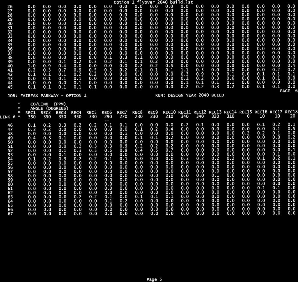
19 Analysis Methodologies & Results The CAL3QHC computer dispersion model was used to predict the 1-hour CO concentrations at the receptor locations shown in Table 6, Figure 2A, Figure 2B, and Figure 3 for Existing (2011), Interim/Opening Year No-Build (2020), Interim/Opening Year Build (2020), Design Year No-Build (2040), and Design Year Build (2040) conditions. All traffic input was provided by Parsons Transportation Group. Worst-case traffic operations and atmospheric conditions were incorporated to predict existing, worst-case CO concentrations. Based on review of the supplied traffic data, the CO modeling analysis for the project corridor focused on the PM-peak conditions. Maximum CO concentrations, calculated by adding together the background concentration to the CO concentration projected for all years considered in the analysis area, are shown in Table 7 and Table 8. The 1-hour background concentration, 2.9 ppm, was derived from VDOT s Consultant Guide. Additionally, a persistence factor of 0.7 was used to project the 8-hour CO concentrations at each interchange location. As shown in Table 7, adjacent to the Fairfax County Parkway and I-95 interchange area (Figure 2A and Figure 2B), the highest 1-hour and 8-hour CO concentrations under Existing (2011) conditions were projected to be 7.3 and 5.1 ppm, respectively, including the assumed background concentration of 2.9 ppm for the 1-hour standard. Under Interim/Opening Year No-Build (2020) conditions, the highest 1-hour and 8-hour CO concentrations were projected to be 6.5 and 4.6 ppm, respectively. Under Option 1 Interim/Opening Year Build (2020) conditions, the highest 1-hour and 8-hour CO concentrations were projected to be 6.5 and 4.6 ppm, respectively. Under Option 2 Interim/Opening Year Build (2020) conditions, the highest 1-hour and 8-hour CO concentrations were projected to be 6.5 and 4.6 ppm, respectively. Under Design Year No-Build (2040) conditions, the highest 1-hour and 8-hour CO concentrations were projected to be 6.7 and 4.7 ppm, respectively. Under Option 1 Design Year Build (2040) conditions, the highest 1-hour and 8-hour CO concentrations were projected to be 6.5 and 4.6 ppm, respectively. Under Option 2 Design Year Build (2040) conditions, the highest 1-hour and 8-hour CO concentrations were projected to be 6.6 and 4.6 ppm, respectively. The highest CO concentrations for all analysis years were projected at receptor site 1D, which represents open areas / parking lots. The second project location is located approximately two miles northwest at the Rolling Road (Route 638) / Franconia-Springfield Parkway (Route 289) interchange area (Figure 3). The results of the analysis are also shown in Table 8. Including the assumed background concentration of 2.9 ppm for the 1-hour standard, the highest 1-hour and 8- hour CO concentrations under Existing (2011) conditions were projected at 4.8 and 3.4 ppm, respectively. Under Interim/Opening Year No-Build (2020) conditions, the highest 1-hour and 8-hour CO concentrations were projected to be 4.8 and 3.4 ppm, respectively. Under Interim/Opening Year Build (2020) conditions, the highest 1-hour and 8-hour CO concentrations were projected to be 4.7 and 3.3 ppm, respectively. Under Design Year No-Build (2040) conditions, the highest 1-hour and 8-hour CO concentrations were projected to be 4.8 and 3.4 ppm, respectively. Under Design Year Build (2040) conditions, the highest 1-hour and 8-hour CO concentrations were projected to be 4.7 and 3.3 ppm, respectively. The highest CO concentration for Existing (2011), Fairfax County Parkway Interchange Improvements Final Report Air Quality Technical Study 16 Fairfax County, VA
20 Table 6 Sensitive Receptor Locations Selected for the Carbon Monoxide Analysis Receptor Location Receptor ID Land Use Receptor Site Description Pedestrian Activity Level Fairfax County Parkway / Loisdale Road Intersection 1A- 1G Open areas / parking lots Southeast quadrant, impact possible due to traffic queues at signal Moderate Fairfax County Parkway / Loisdale Road Intersection 1H - 1N Open areas / parking lots Northeast quadrant, impact possible due to traffic queues at signal Moderate Fairfax County Parkway / Loisdale Road Intersection 1O - 1R Open area Southwest quadrant, impact possible due to traffic queues at signal Low Rolling Road / Spring Forest Court Intersection 2A - 2D Single family townhomes along Tanworth Drive Rolling Road / Spring Forest Court Intersection Hunter Village Drive 2E - 2H 2K Single family townhomes along Spring Forest Court Rolling Road / Spring Forest Court Intersection 2I - 2J Single family townhomes along Wentworth Place High density residential area Northwest quadrant, impact possible due to traffic queues at signal Southwest quadrant, impact possible due to traffic queues at signal Northeast quadrant, impact possible due to traffic queues at signal East quadrant, impact possible due to traffic queues near off-ramp Moderate to High Moderate to High Moderate to High Moderate to High Fairfax County Parkway Interchange Improvements Final Report Air Quality Technical Study 17 Fairfax County, VA
21 Table 7 Fairfax County Parkway / I-95 Interchange Location Carbon Monoxide Analysis 1-Hour and 8-Hour CO Level Summary (ppm) Existing (2011) Interim/Opening Year No-Build (2020) Option 1 Interim/Opening Year Build (2020) Option 2 Interim/Opening Year Build (2020) Design Year No-Build (2040) Option 1 Design Year Build (2040) Option 2 Design Year Build (2040) Receptor ID 1-Hour 8-Hour 1-Hour 8-Hour 1-Hour 8-Hour 1-Hour 8-Hour 1-Hour 8-Hour 1-Hour 8-Hour 1-Hour 8-Hour 1A B Fairfax County Parkway / I-95 Interchange Location 1C D E F G 6.2 1H 4.6 1I 5.0 1J K 1L 1M 6.5 1N 5.8 1O 5.2 1P Q R Notes: 1. 1-Hour and 8-Hour concentrations shown above are in parts per million (ppm) Hour concentrations predicted using CAL3QHC computer dispersion model and assumes a background concentration of 2.9 ppm Hour concentrations were calculated by applying a persistence factor of 0.7 to the 1-Hour concentration, as per the VDOT Consultant Guide, Air Quality Project-Level Analysis, Revision 18, May The persistence factor of 0.7 is based on the guidance in the Guidelines for Modeling Carbon Monoxide from Roadway Intersections, EPA, November Highligted cells represent the highest CO concentrations per analysis year. Fairfax County Parkway Interchange Improvements Final Report Air Quality Technical Study 18 Fairfax County, VA
22 Table 8 Rolling Road / Franconia-Springfield Parkway Interchange Location Carbon Monoxide Analysis 1-Hour and 8-Hour CO Level Summary (ppm) Existing (2011) Interim/Opening Year No-Build (2020) Interim/Opening Year Build (2020) Design Year No- Build (2040) Design Year Build (2040) Receptor ID 1-Hour 8-Hour 1-Hour 8-Hour 1-Hour 8-Hour 1-Hour 8-Hour 1-Hour 8-Hour Rolling Road / Franconia-Springfield Parkway Interchange Location 2A 2B 2C 2D 2E 2F 2G 2H 2I 2J 2K Notes: 1. 1-Hour and 8-Hour concentrations shown above are in parts per million (ppm) Hour concentrations predicted using CAL3QHC computer dispersion model and assumes a background concentration of 2.9 ppm Hour concentrations were calculated by applying a persistence factor of 0.7 to the 1-Hour concentration, as per the VDOT Consultant Guide, Air Quality Project-Level Analysis, Revision 18, May The persistence factor of 0.7 is based on the guidance in the Guidelines for Modeling Carbon Monoxide from Roadway Intersections, EPA, November Highligted cells represent the highest CO concentrations per analysis year. Fairfax County Parkway Interchange Improvements Final Report Air Quality Technical Study 19 Fairfax County, VA
23 Interim/Opening Year No-Build (2020), Interim/Opening Year Build (2020), Design Year No-Build (2040), and Design Year Build (2040) was projected at site 2H, which represents a parking lot area adjacent to the townhomes along Spring Forest Court. In addition, under Design Year Build (2040) conditions, the highest CO concentration was also projected at site 2G, which represents the same land use as site 2H. Under all scenarios for each project location, the highest 1-hour and 8-hour CO concentrations are projected to be below the standards of 35 ppm and 9 ppm, respectively. Additionally, in all cases, the 1-hour CO projections are below the 8-hour standard. Therefore, since the projected 1-hour and 8-hour CO concentrations do not exceed the NAAQS as a result of the proposed improvements, no mitigation measures are required. VI. Fine Particulate Matter Analysis Particle pollution is comprised of a mixture of solid particles and liquid droplets found in the atmosphere. The particles are a combination of several items including dust, dirt, soot, and smoke, and they can vary in size. Particulate matter (PM) created by human activity includes, but is not limited to, the following sources: wood stoves, industry and power plants, and emissions from motor vehicles. It can also be formed in the atmosphere from gases, including sulfur dioxide, nitrogen dioxide, and volatile organic compounds (VOC). Particle pollution includes "inhalable coarse particles" with diameters larger than 2.5 micrometers and smaller than 10 micrometers and "fine particles" with diameters 2.5 micrometers and smaller. The average human hair is about 70 micrometers in diameter making it 30 times larger than the largest fine particle. The project is located in Fairfax County, an area designated as attainment for PM 10 and nonattainment for PM 2.5. Therefore, based on the nonattainment designation for PM 2.5, it will need to be determined whether the project is of air quality concern. The March 2006 final rule provides examples of projects that would not be covered by 40 CFR (b)(1)(i) and (ii) and would not require a PM 2.5 hot-spot analysis (71 FR 12491). Based on the final rule, this project falls within the category of Not a Project of Air Quality Concern. The project addresses the air quality concerns of 40 CFR (b)(1) since the improvements reduce congestion and improve level-of-service (LOS). The Fairfax County Parkway Interchange Improvements fit into the EPA/FHWA Guidance of Example of Projects NOT of Air Quality Concern: (shown below) Example 1: An intersection channelization project or interchange configuration project that involves either turn lanes or slots, or lanes or movements that are physically separated. These kinds of projects improve freeway operations by smoothing traffic flow and vehicle speeds by improving weave and merge operations, which would not be expected to create or worsen PM 2.5 or PM 10 violations. Fairfax County Parkway Interchange Improvements Final Report Air Quality Technical Study 20 Fairfax County, VA
24 Example 2: Intersection channelization projects, traffic circles or roundabouts, intersection signalization projects at individual intersections, and interchange reconfiguration projects that are designed to improve traffic flow and vehicle speeds, and do no involve any increases in idling. Thus, they would be expected to have a neutral or positive influence on PM 2.5 or PM 10 emissions. Based on the above examples, it was determined that the project is not considered a project of air quality concern and has met all the conformity requirements. The proposed improvements at the Fairfax County Parkway / I-95 interchange separate traffic destined to westbound Fairfax County Parkway and local traffic destined to Backlick Road and Boudinot Drive. As a result of the proposed improvements, the separation of traffic in the weave and merge segments between I-95 and Boudinot Drive consequently reduces congestion in that area under Design Year (2040) Build conditions. Additionally, with the provision of a flyover ramp, a portion of traffic is diverted from the slower-speed loop ramp to the higher-speed flyover. At the Rolling Road interchange area, the inside loop ramp is being widened from one to two travel lanes under Design Year (2040) Build conditions. As a result, an additional merge section onto the Fairfax County Parkway improves traffic operations within the merge influence area. The project also addresses the air quality concerns of 40 CFR (b)(1)(i) and (ii) since the study area is a new highway project primarily servicing gasoline vehicle traffic and does not involve a significant number or increase in diesel vehicles. Using conservative assumptions, all trucks were classified as diesel vehicles for the purposes of this assessment. The highest ADT and diesel truck percentage for the Existing (2011) condition 61,900 with a diesel truck percentage of 3%. Additionally, the highest ADT and diesel truck percentage for the Design Year Build (2040) condition was projected to be 69,000 with a diesel truck percentage of 4%. As a result of using conservative assumptions for diesel vehicles, the project is well below the 125,000 ADT and 8% diesel trucks thresholds as identified in the guidance. Additionally, the project is not considered to be a project of air quality concern since it does not change the LOS to D, E, or F because of increased traffic volumes from a significant number of diesel vehicles related to the project. As shown in Table 2, the project will not result in any meaningful changes in traffic volumes, diesel vehicles, vehicle mix, or changes in the facility relative to the No-Build alternative. In addition, the intersection and interchange improvements associated with this project are designed to improve traffic flow and vehicle speeds and do not involve any increases in idling (as discussed above). Based on the above information, it was determined that the project is not considered a project of air quality concern with respect to particulate matter, is located in a geographic area that is in attainment for PM 2.5, and has met all the state and federal requirements as identified in the March 2006 final rule. The project will not cause or contribute to a new violation of the PM 2.5 NAAQS or increase the frequency or severity of a violation. Fairfax County Parkway Interchange Improvements Final Report Air Quality Technical Study 21 Fairfax County, VA
25 VII. Mobile Source Air Toxics On February 3, 2006, FHWA issued guidance for the assessment of Mobile Source Air Toxics (MSAT) in the NEPA process for highways. The MSAT guidance included specific criteria for determining whether projects are to be considered exempt from MSAT analysis requirements, or if they may require a qualitative assessment or a quantitative analysis. In response, VDOT updated the Consultant Guide to reflect the guidance released by FHWA. On September 30, 2009, FHWA issued Interim Guidance Update on Mobile Source Air Toxic Analysis in NEPA Documents. This interim guidance update reflects recent regulatory changes; addresses stakeholder requests to broaden the horizon years of emission trends performed with MOBILE6.2; and updates stakeholders on the status of scientific research on air toxics. The purpose of the project is to provide direct access from I-95 northbound to the Fairfax County Parkway westbound by constructing a flyover ramp. Additionally, as part of the proposed improvements, the inside loop ramp at the Rolling Road / Franconia-Springfield Parkway interchange area will be widened from a single-lane to a two-lane off-ramp to provide access to westbound Fairfax County Parkway. In accordance with the updated guidance, this project is best characterized as a project with no meaningful potential MSAT effects. Based on this approach, no analysis is required since the proposed project will not result in any meaningful changes in traffic volumes, vehicle mix, or changes in the facility relative to the No-Build alternative. As shown in Table 2, the project has negligible impacts on traffic under Interim/Opening Year (2020) and Design Year Build (2020) conditions, regardless of alternative. It is also anticipated that the proposed improvements would improve traffic flow and vehicle speeds and do not involve any increases in idling. Therefore, FHWA has determined that the Fairfax County Parkway Interchange Improvements will generate minimal air quality impacts for CAAA criteria pollutants and have not been linked with any special MSAT concerns. Consequently, this effort is exempt from analysis for MSAT. Moreover, EPA regulations for vehicle engines and fuels will cause overall MSAT emissions to decline significantly over the next several decades. Based on regulations now in effect, an analysis of national trends with EPA s MOBILE6.2 model forecasts a combined reduction of 72 percent in the total annual emission rate for the priority MSAT from 1999 to 2050 while vehicle-miles of travel are projected to increase by 145 percent. This trend will both reduce the background level of MSAT as well as the possibility of even minor MSAT emission from this project. VIII. Construction Impacts The temporary air quality impacts from construction are not expected to be significant. Emissions will be produced during the construction of this project by heavy equipment and vehicle travel to and from the site. Earthmoving and ground-disturbing operations will generate airborne dust. Construction emissions are short term or temporary in nature. In order to mitigate these emissions, all construction activities are to be performed in accordance with VDOT s Road and Bridge Specifications. These Fairfax County Parkway Interchange Improvements Final Report Air Quality Technical Study 22 Fairfax County, VA
26 specifications are approved as conforming to the State Implementation Plan and require compliance with all applicable local, state, and federal regulations. The project lies in an area designated by the Virginia Department of Environmental Quality (VDEQ) as an emissions control area for volatile organic compounds (VOC) and nitrogen oxides (NOx) (9VAC ). In addition, for work in this area, the following VDEQ air pollution regulations must be adhered to during the construction of this project: 9VAC restrictions; 9VAC , Cutback Asphalt restrictions; and 9 VAC , Fugitive Dust precautions. IX. Conformity Status of the Project The project has also been evaluated with respect to regional air quality concerns. The Clean Air Act Amendments (CAAA) of 1990 mandate improvements to the nation s air quality. The final conformity regulations promulgated by the US EPA in 1997, as part of 40 CFR Part 93, require that transportation plans and programs conform to the State Implementation Plan (SIP). The final conformity rule requires that transportation plans in ozone nonattainment areas are consistent with the most recent estimates of mobile source emissions; provide for the expeditious implementation of transportation control measures in the applicable implementation plan; and contribute to annual emission reductions in ozone and carbon monoxide nonattainment areas. Based on the CAAA and most recent EPA classifications, Fairfax County has been designated as nonattainment for ozone and PM 2.5 ; therefore, the project is subject to regional conformity requirements. The Fairfax County Parkway Interchange Improvements Project was included in the National Capital Region Transportation Planning Board s FY 2011 Constrained Long Range Plan (CLRP) and FY Transportation Improvement Program (TIP), which has been found to conform to both the 8-hour ozone and PM 2.5 NAAQS. Therefore, since the project is part of a conforming TIP, it has met all conformity requirements as outlined by the CAAA of X. Conclusion Based on the results of the air quality analysis, CO concentrations with the Build Alternatives are predicted to be well below the NAAQS in both the Opening Year (2020) and Design Year (2040). Therefore, since projected CO levels are below the NAAQS under Build conditions, no exceedences are anticipated as a result of the proposed project and no mitigation measures are required. Additionally, Fairfax County has been designated as nonattainment for PM 2.5 ; however, no analysis is required as part of the air quality assessment since the project was not found to be a project of air quality concern. Similarly, the project has been determined to generate minimal air quality impacts for the CAAA criteria pollutants and has not yet been linked with any special MSAT concerns. The proposed project will not result in any meaningful changes in traffic volumes, vehicle mix, or changes in the facility relative to the No-Build alternative (as shown in Table 2). As such, FHWA has determined that the Fairfax County Parkway Interchange Improvements will generate minimal air quality impacts for CAAA criteria pollutants and is not linked with any special MSAT concerns. Consequently, this project was found to have no meaningful impact on MSAT. Fairfax County Parkway Interchange Improvements Final Report Air Quality Technical Study 23 Fairfax County, VA
27 The temporary air quality impacts from construction are not expected to be significant. Construction activities are to be performed in accordance with VDOT s current Road and Bridge Specifications. The project is regionally significant and regional conformity requirements apply; it originates from regional financially constrained long range transportation plans and Transportation Improvement Programs that have been found to conform to the State Implementation Plan. The project completion schedule, design concept, and scope are correctly reflected in the currently conforming transportation plans and programs. Finally, the project is not expected to cause or contribute to any violations of the NAAQS or to interfere with the attainment or maintenance of the applicable NAAQS. The results of the air study reevaluation are consistent with the results presented in the Fairfax County Parkway Interchange Improvements Air Quality Analysis March Fairfax County Parkway Interchange Improvements Final Report Air Quality Technical Study 24 Fairfax County, VA

28
29

30

31
32
33
34

35
36

37

38
39

40

41

42
43
44
45

46
47
48

49
50
51

52

53
54
55

56

57

58

59
60
61

62

63

64
65

66

67

68

69
70

71

72

73

74
75

76

77

78

79


80

81

82

83
84
85

86

87

88
89

90

91
92
93
94

95

96
97

98
99
100

101

102

103
104

105

106

107

108
109
110
111

112
113

114
115 APPENDIX C TRAFFIC SUMMARY / SYNCHRO REPORTS
116 HCM Signalized Intersection Capacity Analysis 3: Spring Forest & Rolling Road 1/27/2012 Movement EBL EBT EBR WBL WBT WBR NBL NBT NBR SBL SBT SBR Lane Configurations Volume (vph) Ideal Flow (vphpl) Total Lost time (s) Lane Util. Factor Frt Flt Protected Satd. Flow (prot) Flt Permitted Satd. Flow (perm) Peak-hour factor, PHF Adj. Flow (vph) RTOR Reduction (vph) Lane Group Flow (vph) Turn Type Split Split Perm pm+pt Free pm+pt Perm Protected Phases Permitted Phases 3 6 Free 2 2 Actuated Green, G (s) Effective Green, g (s) Actuated g/c Ratio Clearance Time (s) Vehicle Extension (s) Lane Grp Cap (vph) v/s Ratio Prot c c c0.41 v/s Ratio Perm c v/c Ratio Uniform Delay, d Progression Factor Incremental Delay, d Delay (s) Level of Service D D D D D B A A B C B Approach Delay (s) Approach LOS D D A C Intersection Summary HCM Average Control Delay 19.2 HCM Level of Service B HCM Volume to Capacity ratio 0.62 Actuated Cycle Length (s) Sum of lost time (s) 20.0 Intersection Capacity Utilization 67.5% ICU Level of Service C Analysis Period (min) 15 c Critical Lane Group Existing AM Synchro 7 - Report Page 1
117 HCM Signalized Intersection Capacity Analysis 6: Ramps to 7900/Hooes & Rolling Road 1/27/2012 Movement EBL EBT EBR WBL WBT WBR NBL NBT NBR SBL SBT SBR Lane Configurations Volume (vph) Ideal Flow (vphpl) Total Lost time (s) Lane Util. Factor Frt Flt Protected Satd. Flow (prot) Flt Permitted Satd. Flow (perm) Peak-hour factor, PHF Adj. Flow (vph) RTOR Reduction (vph) Lane Group Flow (vph) Turn Type Perm Prot Protected Phases Permitted Phases 4 Actuated Green, G (s) Effective Green, g (s) Actuated g/c Ratio Clearance Time (s) Vehicle Extension (s) Lane Grp Cap (vph) v/s Ratio Prot 0.16 c0.12 c0.33 v/s Ratio Perm v/c Ratio Uniform Delay, d Progression Factor Incremental Delay, d Delay (s) Level of Service D D B C A Approach Delay (s) Approach LOS D A B B Intersection Summary HCM Average Control Delay 11.6 HCM Level of Service B HCM Volume to Capacity ratio 0.44 Actuated Cycle Length (s) Sum of lost time (s) 14.0 Intersection Capacity Utilization 50.4% ICU Level of Service A Analysis Period (min) 15 c Critical Lane Group Existing AM Synchro 7 - Report Page 2
118 HCM Signalized Intersection Capacity Analysis 40: Ramp from NB I-95 & Fairfax Co Pkwy 1/27/2012 Movement EBL EBT EBR WBL WBT WBR NBL NBT NBR SBL SBT SBR Lane Configurations Volume (vph) Ideal Flow (vphpl) Grade (%) 0% 0% 0% 4% Total Lost time (s) Lane Util. Factor * Frt Flt Protected Satd. Flow (prot) Flt Permitted Satd. Flow (perm) Peak-hour factor, PHF Adj. Flow (vph) RTOR Reduction (vph) Lane Group Flow (vph) Heavy Vehicles (%) 2% 2% 2% 2% 2% 2% 2% 6% 2% 2% 2% 2% Turn Type Split Free custom custom Prot Protected Phases Permitted Phases Free Actuated Green, G (s) Effective Green, g (s) Actuated g/c Ratio Clearance Time (s) Vehicle Extension (s) Lane Grp Cap (vph) v/s Ratio Prot c0.28 c c0.65 v/s Ratio Perm v/c Ratio Uniform Delay, d Progression Factor Incremental Delay, d Delay (s) Level of Service F A D C C E E Approach Delay (s) Approach LOS E D C E Intersection Summary HCM Average Control Delay 57.1 HCM Level of Service E HCM Volume to Capacity ratio 1.07 Actuated Cycle Length (s) Sum of lost time (s) 9.0 Intersection Capacity Utilization 97.0% ICU Level of Service F Analysis Period (min) 15 c Critical Lane Group Existing AM Synchro 7 - Report Page 3
119 HCM Signalized Intersection Capacity Analysis 3: Spring Forest & Rolling Road 1/27/2012 Movement EBL EBT EBR WBL WBT WBR NBL NBT NBR SBL SBT SBR Lane Configurations Volume (vph) Ideal Flow (vphpl) Total Lost time (s) Lane Util. Factor Frt Flt Protected Satd. Flow (prot) Flt Permitted Satd. Flow (perm) Peak-hour factor, PHF Adj. Flow (vph) RTOR Reduction (vph) Lane Group Flow (vph) Turn Type Split Split Perm pm+pt Free pm+pt Perm Protected Phases Permitted Phases 3 6 Free 2 2 Actuated Green, G (s) Effective Green, g (s) Actuated g/c Ratio Clearance Time (s) Vehicle Extension (s) Lane Grp Cap (vph) v/s Ratio Prot c0.45 c v/s Ratio Perm c0.48 c v/c Ratio Uniform Delay, d Progression Factor Incremental Delay, d Delay (s) Level of Service F F E E E B C A F B B Approach Delay (s) Approach LOS F E B D Intersection Summary HCM Average Control Delay 29.7 HCM Level of Service C HCM Volume to Capacity ratio 0.88 Actuated Cycle Length (s) Sum of lost time (s) 13.5 Intersection Capacity Utilization 87.2% ICU Level of Service E Analysis Period (min) 15 c Critical Lane Group Existing PM Synchro 7 - Report Page 1
120 HCM Signalized Intersection Capacity Analysis 6: Ramps to 7900/Hooes & Rolling Road 1/27/2012 Movement EBL EBT EBR WBL WBT WBR NBL NBT NBR SBL SBT SBR Lane Configurations Volume (vph) Ideal Flow (vphpl) Total Lost time (s) Lane Util. Factor Frt Flt Protected Satd. Flow (prot) Flt Permitted Satd. Flow (perm) Peak-hour factor, PHF Adj. Flow (vph) RTOR Reduction (vph) Lane Group Flow (vph) Turn Type Perm Prot Protected Phases Permitted Phases 4 Actuated Green, G (s) Effective Green, g (s) Actuated g/c Ratio Clearance Time (s) Vehicle Extension (s) Lane Grp Cap (vph) v/s Ratio Prot c0.46 c v/s Ratio Perm c v/c Ratio Uniform Delay, d Progression Factor Incremental Delay, d Delay (s) Level of Service F F B E A Approach Delay (s) Approach LOS F A B C Intersection Summary HCM Average Control Delay 21.0 HCM Level of Service C HCM Volume to Capacity ratio 0.68 Actuated Cycle Length (s) Sum of lost time (s) 20.0 Intersection Capacity Utilization 75.2% ICU Level of Service D Analysis Period (min) 15 c Critical Lane Group Existing PM Synchro 7 - Report Page 2
121 HCM Signalized Intersection Capacity Analysis 40: Ramp from NB I-95 & Fairfax Co Pkwy 1/27/2012 Movement EBL EBT EBR WBL WBT WBR NBL NBT NBR SBL SBT SBR Lane Configurations Volume (vph) Ideal Flow (vphpl) Grade (%) 0% 0% 0% 4% Total Lost time (s) Lane Util. Factor * Frt Flt Protected Satd. Flow (prot) Flt Permitted Satd. Flow (perm) Peak-hour factor, PHF Adj. Flow (vph) RTOR Reduction (vph) Lane Group Flow (vph) Heavy Vehicles (%) 2% 2% 2% 2% 2% 2% 2% 6% 2% 2% 2% 2% Turn Type Split Free custom custom Prot Protected Phases Permitted Phases Free Actuated Green, G (s) Effective Green, g (s) Actuated g/c Ratio Clearance Time (s) Vehicle Extension (s) Lane Grp Cap (vph) v/s Ratio Prot c0.08 c c0.73 c v/s Ratio Perm v/c Ratio Uniform Delay, d Progression Factor Incremental Delay, d Delay (s) Level of Service F A F E F F B Approach Delay (s) Approach LOS E F F D Intersection Summary HCM Average Control Delay 93.0 HCM Level of Service F HCM Volume to Capacity ratio 1.19 Actuated Cycle Length (s) Sum of lost time (s) 12.0 Intersection Capacity Utilization 103.2% ICU Level of Service G Analysis Period (min) 15 c Critical Lane Group Existing PM Synchro 7 - Report Page 3
122 HCM Signalized Intersection Capacity Analysis 3: Spring Forest & Rolling Road 1/27/2012 Movement EBL EBT EBR WBL WBT WBR NBL NBT NBR SBL SBT SBR Lane Configurations Volume (vph) Ideal Flow (vphpl) Total Lost time (s) Lane Util. Factor Frt Flt Protected Satd. Flow (prot) Flt Permitted Satd. Flow (perm) Peak-hour factor, PHF Adj. Flow (vph) RTOR Reduction (vph) Lane Group Flow (vph) Turn Type Split Split Perm pm+pt Free pm+pt Perm Protected Phases Permitted Phases 3 6 Free 2 2 Actuated Green, G (s) Effective Green, g (s) Actuated g/c Ratio Clearance Time (s) Vehicle Extension (s) Lane Grp Cap (vph) v/s Ratio Prot c c0.45 v/s Ratio Perm c v/c Ratio Uniform Delay, d Progression Factor Incremental Delay, d Delay (s) Level of Service E E D D D C B A B C B Approach Delay (s) Approach LOS E D B C Intersection Summary HCM Average Control Delay 24.9 HCM Level of Service C HCM Volume to Capacity ratio 0.66 Actuated Cycle Length (s) Sum of lost time (s) 13.5 Intersection Capacity Utilization 68.4% ICU Level of Service C Analysis Period (min) 15 c Critical Lane Group 2020 AM Build Synchro 7 - Report Page 1
123 HCM Signalized Intersection Capacity Analysis 6: Ramps to 7900/Hooes & Rolling Road 1/27/2012 Movement WBL WBR NBT NBR SBL SBT Lane Configurations Volume (vph) Ideal Flow (vphpl) Total Lost time (s) Lane Util. Factor Frt Flt Protected Satd. Flow (prot) Flt Permitted Satd. Flow (perm) Peak-hour factor, PHF Adj. Flow (vph) RTOR Reduction (vph) Lane Group Flow (vph) Turn Type Perm Perm Prot Protected Phases Permitted Phases 4 6 Actuated Green, G (s) Effective Green, g (s) Actuated g/c Ratio Clearance Time (s) Vehicle Extension (s) Lane Grp Cap (vph) v/s Ratio Prot c0.11 c0.46 v/s Ratio Perm c v/c Ratio Uniform Delay, d Progression Factor Incremental Delay, d Delay (s) Level of Service D D B B D A Approach Delay (s) Approach LOS D B B Intersection Summary HCM Average Control Delay 16.5 HCM Level of Service B HCM Volume to Capacity ratio 0.53 Actuated Cycle Length (s) Sum of lost time (s) 14.0 Intersection Capacity Utilization 55.2% ICU Level of Service B Analysis Period (min) 15 c Critical Lane Group 2020 AM Build Synchro 7 - Report Page 2
124 HCM Signalized Intersection Capacity Analysis 40: Ramp from NB I-95 & Fairfax Co Pkwy 1/27/2012 Movement EBL EBT EBR WBL WBT WBR NBL NBT NBR SBL SBT SBR Lane Configurations Volume (vph) Ideal Flow (vphpl) Grade (%) 0% 0% 0% 4% Total Lost time (s) Lane Util. Factor * Frt Flt Protected Satd. Flow (prot) Flt Permitted Satd. Flow (perm) Peak-hour factor, PHF Adj. Flow (vph) RTOR Reduction (vph) Lane Group Flow (vph) Heavy Vehicles (%) 2% 2% 2% 2% 2% 2% 2% 6% 2% 2% 2% 2% Turn Type Split Free custom custom Prot Protected Phases Permitted Phases Free Actuated Green, G (s) Effective Green, g (s) Actuated g/c Ratio Clearance Time (s) Vehicle Extension (s) Lane Grp Cap (vph) v/s Ratio Prot c c0.63 v/s Ratio Perm c v/c Ratio Uniform Delay, d Progression Factor Incremental Delay, d Delay (s) Level of Service F A D C D E E Approach Delay (s) Approach LOS E D D E Intersection Summary HCM Average Control Delay 62.6 HCM Level of Service E HCM Volume to Capacity ratio 1.03 Actuated Cycle Length (s) Sum of lost time (s) 6.0 Intersection Capacity Utilization 91.8% ICU Level of Service F Analysis Period (min) 15 c Critical Lane Group 2020 AM Build Synchro 7 - Report Page 3
125 HCM Signalized Intersection Capacity Analysis 3: Spring Forest & Rolling Road 1/27/2012 Movement EBL EBT EBR WBL WBT WBR NBL NBT NBR SBL SBT SBR Lane Configurations Volume (vph) Ideal Flow (vphpl) Total Lost time (s) Lane Util. Factor Frt Flt Protected Satd. Flow (prot) Flt Permitted Satd. Flow (perm) Peak-hour factor, PHF Adj. Flow (vph) RTOR Reduction (vph) Lane Group Flow (vph) Turn Type Split Split Perm pm+pt Free pm+pt Perm Protected Phases Permitted Phases 3 6 Free 2 2 Actuated Green, G (s) Effective Green, g (s) Actuated g/c Ratio Clearance Time (s) Vehicle Extension (s) Lane Grp Cap (vph) v/s Ratio Prot c c0.47 c v/s Ratio Perm c0.32 c v/c Ratio Uniform Delay, d Progression Factor Incremental Delay, d Delay (s) Level of Service E E F F E C D A F C B Approach Delay (s) Approach LOS E E C D Intersection Summary HCM Average Control Delay 36.9 HCM Level of Service D HCM Volume to Capacity ratio 0.90 Actuated Cycle Length (s) Sum of lost time (s) 20.5 Intersection Capacity Utilization 91.2% ICU Level of Service F Analysis Period (min) 15 c Critical Lane Group 2020 PM Build Synchro 7 - Report Page 1
126 HCM Signalized Intersection Capacity Analysis 6: Ramps to 7900/Hooes & Rolling Road 1/27/2012 Movement WBL WBR NBT NBR SBL SBT Lane Configurations Volume (vph) Ideal Flow (vphpl) Total Lost time (s) Lane Util. Factor Frt Flt Protected Satd. Flow (prot) Flt Permitted Satd. Flow (perm) Peak-hour factor, PHF Adj. Flow (vph) RTOR Reduction (vph) Lane Group Flow (vph) Turn Type Perm Perm Prot Protected Phases Permitted Phases 4 6 Actuated Green, G (s) Effective Green, g (s) Actuated g/c Ratio Clearance Time (s) Vehicle Extension (s) Lane Grp Cap (vph) v/s Ratio Prot c0.01 c0.44 c v/s Ratio Perm v/c Ratio Uniform Delay, d Progression Factor Incremental Delay, d Delay (s) Level of Service E E B B E A Approach Delay (s) Approach LOS E B B Intersection Summary HCM Average Control Delay 17.5 HCM Level of Service B HCM Volume to Capacity ratio 0.62 Actuated Cycle Length (s) Sum of lost time (s) 20.0 Intersection Capacity Utilization 68.2% ICU Level of Service C Analysis Period (min) 15 c Critical Lane Group 2020 PM Build Synchro 7 - Report Page 2
127 HCM Signalized Intersection Capacity Analysis 40: Ramp from NB I-95 & Fairfax Co Pkwy 1/27/2012 Movement EBL EBT EBR WBL WBT WBR NBL NBT NBR SBL SBT SBR Lane Configurations Volume (vph) Ideal Flow (vphpl) Grade (%) 0% 0% 0% 4% Total Lost time (s) Lane Util. Factor * Frt Flt Protected Satd. Flow (prot) Flt Permitted Satd. Flow (perm) Peak-hour factor, PHF Adj. Flow (vph) RTOR Reduction (vph) Lane Group Flow (vph) Heavy Vehicles (%) 2% 2% 2% 2% 2% 2% 2% 6% 2% 2% 2% 2% Turn Type Split Free custom custom Prot Protected Phases Permitted Phases Free Actuated Green, G (s) Effective Green, g (s) Actuated g/c Ratio Clearance Time (s) Vehicle Extension (s) Lane Grp Cap (vph) v/s Ratio Prot c c0.15 c0.66 c v/s Ratio Perm v/c Ratio Uniform Delay, d Progression Factor Incremental Delay, d Delay (s) Level of Service F A F F F F A Approach Delay (s) Approach LOS E F F D Intersection Summary HCM Average Control Delay 73.0 HCM Level of Service E HCM Volume to Capacity ratio 1.12 Actuated Cycle Length (s) Sum of lost time (s) 12.0 Intersection Capacity Utilization 99.1% ICU Level of Service F Analysis Period (min) 15 c Critical Lane Group 2020 PM Build Synchro 7 - Report Page 3
128 Timings 40: Ramp from NB I-95 & Fairfax Co Pkwy 2/17/2012 Lane Group EBL EBT EBR WBL WBR NBT SBL SBT Lane Configurations Volume (vph) Turn Type Split Free custom custom Prot Protected Phases Permitted Phases Free Detector Phase Switch Phase Minimum Initial (s) Minimum Split (s) Total Split (s) Total Split (%) 30.0% 30.0% 0.0% 11.7% 21.7% 36.7% 21.7% 58.3% Yellow Time (s) All-Red Time (s) Lost Time Adjust (s) Total Lost Time (s) Lead/Lag Lead Lead Lag Lead Lag Lead Lead-Lag Optimize? Recall Mode None None None None Max None Max Act Effct Green (s) Actuated g/c Ratio v/c Ratio Control Delay Queue Delay Total Delay LOS C F A D A D E E Approach Delay Approach LOS E D E Intersection Summary Cycle Length: 120 Actuated Cycle Length: Natural Cycle: 150 Control Type: Semi Act-Uncoord Maximum v/c Ratio: 1.12 Intersection Signal Delay: 53.9 Intersection Capacity Utilization 91.8% Analysis Period (min) 15 Intersection LOS: D ICU Level of Service F Splits and Phases: 40: Ramp from NB I-95 & Fairfax Co Pkwy 2020 AM Build2 Synchro 7 - Report Page 1
129 Timings 40: Ramp from NB I-95 & Fairfax Co Pkwy 2/17/2012 Lane Group EBL EBT EBR WBL WBR NBT SBL SBT Lane Configurations Volume (vph) Turn Type Split Free custom custom Prot Protected Phases Permitted Phases Free Detector Phase Switch Phase Minimum Initial (s) Minimum Split (s) Total Split (s) Total Split (%) 12.0% 12.0% 0.0% 9.3% 18.7% 60.0% 18.7% 78.7% Yellow Time (s) All-Red Time (s) Lost Time Adjust (s) Total Lost Time (s) Lead/Lag Lead Lead Lag Lead Lag Lead Lead-Lag Optimize? Recall Mode None None None None Max None Max Act Effct Green (s) Actuated g/c Ratio v/c Ratio Control Delay Queue Delay Total Delay LOS F F A F F F F A Approach Delay Approach LOS E F C Intersection Summary Cycle Length: 150 Actuated Cycle Length: 150 Natural Cycle: 150 Control Type: Semi Act-Uncoord Maximum v/c Ratio: 1.20 Intersection Signal Delay: 80.9 Intersection Capacity Utilization 96.6% Analysis Period (min) 15 Intersection LOS: F ICU Level of Service F Splits and Phases: 40: Ramp from NB I-95 & Fairfax Co Pkwy 2020 PM Build2 Synchro 7 - Report Page 1
130 HCM Signalized Intersection Capacity Analysis 3: Spring Forest & Rolling Road 1/27/2012 Movement EBL EBT EBR WBL WBT WBR NBL NBT NBR SBL SBT SBR Lane Configurations Volume (vph) Ideal Flow (vphpl) Total Lost time (s) Lane Util. Factor Frt Flt Protected Satd. Flow (prot) Flt Permitted Satd. Flow (perm) Peak-hour factor, PHF Adj. Flow (vph) RTOR Reduction (vph) Lane Group Flow (vph) Turn Type Split Split Perm pm+pt Free pm+pt Perm Protected Phases Permitted Phases 3 6 Free 2 2 Actuated Green, G (s) Effective Green, g (s) Actuated g/c Ratio Clearance Time (s) Vehicle Extension (s) Lane Grp Cap (vph) v/s Ratio Prot c c0.45 v/s Ratio Perm c v/c Ratio Uniform Delay, d Progression Factor Incremental Delay, d Delay (s) Level of Service E E D D D C B A B C B Approach Delay (s) Approach LOS E D B C Intersection Summary HCM Average Control Delay 24.9 HCM Level of Service C HCM Volume to Capacity ratio 0.68 Actuated Cycle Length (s) Sum of lost time (s) 13.5 Intersection Capacity Utilization 68.4% ICU Level of Service C Analysis Period (min) 15 c Critical Lane Group 2020 AM No Build Synchro 7 - Report Page 1
131 HCM Signalized Intersection Capacity Analysis 6: Ramps to 7900/Hooes & Rolling Road 1/27/2012 Movement WBL WBR NBT NBR SBL SBT Lane Configurations Volume (vph) Ideal Flow (vphpl) Total Lost time (s) Lane Util. Factor Frt Flt Protected Satd. Flow (prot) Flt Permitted Satd. Flow (perm) Peak-hour factor, PHF Adj. Flow (vph) RTOR Reduction (vph) Lane Group Flow (vph) Turn Type Perm Perm Prot Protected Phases Permitted Phases 4 6 Actuated Green, G (s) Effective Green, g (s) Actuated g/c Ratio Clearance Time (s) Vehicle Extension (s) Lane Grp Cap (vph) v/s Ratio Prot c0.11 c0.46 v/s Ratio Perm c v/c Ratio Uniform Delay, d Progression Factor Incremental Delay, d Delay (s) Level of Service D D B B D A Approach Delay (s) Approach LOS D B B Intersection Summary HCM Average Control Delay 16.5 HCM Level of Service B HCM Volume to Capacity ratio 0.53 Actuated Cycle Length (s) Sum of lost time (s) 14.0 Intersection Capacity Utilization 55.2% ICU Level of Service B Analysis Period (min) 15 c Critical Lane Group 2020 AM No Build Synchro 7 - Report Page 2
132 HCM Signalized Intersection Capacity Analysis 40: Ramp from NB I-95 & Fairfax Co Pkwy 1/27/2012 Movement EBL EBT EBR WBL WBT WBR NBL NBT NBR SBL SBT SBR Lane Configurations Volume (vph) Ideal Flow (vphpl) Grade (%) 0% 0% 0% 4% Total Lost time (s) Lane Util. Factor * Frt Flt Protected Satd. Flow (prot) Flt Permitted Satd. Flow (perm) Peak-hour factor, PHF Adj. Flow (vph) RTOR Reduction (vph) Lane Group Flow (vph) Heavy Vehicles (%) 2% 2% 2% 2% 2% 2% 2% 6% 2% 2% 2% 2% Turn Type Split Free custom custom Prot Protected Phases Permitted Phases Free Actuated Green, G (s) Effective Green, g (s) Actuated g/c Ratio Clearance Time (s) Vehicle Extension (s) Lane Grp Cap (vph) v/s Ratio Prot c c0.63 v/s Ratio Perm c v/c Ratio Uniform Delay, d Progression Factor Incremental Delay, d Delay (s) Level of Service F A D C D E E Approach Delay (s) Approach LOS E D D E Intersection Summary HCM Average Control Delay 62.6 HCM Level of Service E HCM Volume to Capacity ratio 1.03 Actuated Cycle Length (s) Sum of lost time (s) 6.0 Intersection Capacity Utilization 91.8% ICU Level of Service F Analysis Period (min) 15 c Critical Lane Group 2020 AM No Build Synchro 7 - Report Page 3
133 HCM Signalized Intersection Capacity Analysis 3: Spring Forest & Rolling Road 1/27/2012 Movement EBL EBT EBR WBL WBT WBR NBL NBT NBR SBL SBT SBR Lane Configurations Volume (vph) Ideal Flow (vphpl) Total Lost time (s) Lane Util. Factor Frt Flt Protected Satd. Flow (prot) Flt Permitted Satd. Flow (perm) Peak-hour factor, PHF Adj. Flow (vph) RTOR Reduction (vph) Lane Group Flow (vph) Turn Type Split Split Perm pm+pt Free pm+pt Perm Protected Phases Permitted Phases 3 6 Free 2 2 Actuated Green, G (s) Effective Green, g (s) Actuated g/c Ratio Clearance Time (s) Vehicle Extension (s) Lane Grp Cap (vph) v/s Ratio Prot c c0.47 c v/s Ratio Perm c0.57 c v/c Ratio Uniform Delay, d Progression Factor Incremental Delay, d Delay (s) Level of Service E E F F E C D A F C B Approach Delay (s) Approach LOS E E C D Intersection Summary HCM Average Control Delay 37.0 HCM Level of Service D HCM Volume to Capacity ratio 0.92 Actuated Cycle Length (s) Sum of lost time (s) 20.5 Intersection Capacity Utilization 91.2% ICU Level of Service F Analysis Period (min) 15 c Critical Lane Group 2020 PM No Build Synchro 7 - Report Page 1
134 HCM Signalized Intersection Capacity Analysis 6: Ramps to 7900/Hooes & Rolling Road 1/27/2012 Movement WBL WBR NBT NBR SBL SBT Lane Configurations Volume (vph) Ideal Flow (vphpl) Total Lost time (s) Lane Util. Factor Frt Flt Protected Satd. Flow (prot) Flt Permitted Satd. Flow (perm) Peak-hour factor, PHF Adj. Flow (vph) RTOR Reduction (vph) Lane Group Flow (vph) Turn Type Perm Perm Prot Protected Phases Permitted Phases 4 6 Actuated Green, G (s) Effective Green, g (s) Actuated g/c Ratio Clearance Time (s) Vehicle Extension (s) Lane Grp Cap (vph) v/s Ratio Prot c0.01 c0.44 c v/s Ratio Perm v/c Ratio Uniform Delay, d Progression Factor Incremental Delay, d Delay (s) Level of Service E E B B E A Approach Delay (s) Approach LOS E B B Intersection Summary HCM Average Control Delay 17.5 HCM Level of Service B HCM Volume to Capacity ratio 0.62 Actuated Cycle Length (s) Sum of lost time (s) 20.0 Intersection Capacity Utilization 68.2% ICU Level of Service C Analysis Period (min) 15 c Critical Lane Group 2020 PM No Build Synchro 7 - Report Page 2
135 HCM Signalized Intersection Capacity Analysis 40: Ramp from NB I-95 & Fairfax Co Pkwy 1/27/2012 Movement EBL EBT EBR WBL WBT WBR NBL NBT NBR SBL SBT SBR Lane Configurations Volume (vph) Ideal Flow (vphpl) Grade (%) 0% 0% 0% 4% Total Lost time (s) Lane Util. Factor * Frt Flt Protected Satd. Flow (prot) Flt Permitted Satd. Flow (perm) Peak-hour factor, PHF Adj. Flow (vph) RTOR Reduction (vph) Lane Group Flow (vph) Heavy Vehicles (%) 2% 2% 2% 2% 2% 2% 2% 6% 2% 2% 2% 2% Turn Type Split Free custom custom Prot Protected Phases Permitted Phases Free Actuated Green, G (s) Effective Green, g (s) Actuated g/c Ratio Clearance Time (s) Vehicle Extension (s) Lane Grp Cap (vph) v/s Ratio Prot c c0.15 c0.66 c v/s Ratio Perm v/c Ratio Uniform Delay, d Progression Factor Incremental Delay, d Delay (s) Level of Service F A F F F F A Approach Delay (s) Approach LOS E F F D Intersection Summary HCM Average Control Delay 73.0 HCM Level of Service E HCM Volume to Capacity ratio 1.12 Actuated Cycle Length (s) Sum of lost time (s) 12.0 Intersection Capacity Utilization 99.1% ICU Level of Service F Analysis Period (min) 15 c Critical Lane Group 2020 PM No Build Synchro 7 - Report Page 3
136 HCM Signalized Intersection Capacity Analysis 3: Spring Forest & Rolling Road 1/27/2012 Movement EBL EBT EBR WBL WBT WBR NBL NBT NBR SBL SBT SBR Lane Configurations Volume (vph) Ideal Flow (vphpl) Total Lost time (s) Lane Util. Factor Frt Flt Protected Satd. Flow (prot) Flt Permitted Satd. Flow (perm) Peak-hour factor, PHF Adj. Flow (vph) RTOR Reduction (vph) Lane Group Flow (vph) Turn Type Split Split Perm pm+pt Free pm+pt Perm Protected Phases Permitted Phases 3 6 Free 2 2 Actuated Green, G (s) Effective Green, g (s) Actuated g/c Ratio Clearance Time (s) Vehicle Extension (s) Lane Grp Cap (vph) v/s Ratio Prot c c c0.47 v/s Ratio Perm c v/c Ratio Uniform Delay, d Progression Factor Incremental Delay, d Delay (s) Level of Service E E E D D D B A B D B Approach Delay (s) Approach LOS E D B D Intersection Summary HCM Average Control Delay 37.5 HCM Level of Service D HCM Volume to Capacity ratio 0.79 Actuated Cycle Length (s) Sum of lost time (s) 13.5 Intersection Capacity Utilization 77.6% ICU Level of Service D Analysis Period (min) 15 c Critical Lane Group 2040 AM Build Synchro 7 - Report Page 1
137 HCM Signalized Intersection Capacity Analysis 6: Ramps to 7900/Hooes & Rolling Road 1/27/2012 Movement WBL WBR NBT NBR SBL SBT Lane Configurations Volume (vph) Ideal Flow (vphpl) Total Lost time (s) Lane Util. Factor Frt Flt Protected Satd. Flow (prot) Flt Permitted Satd. Flow (perm) Peak-hour factor, PHF Adj. Flow (vph) RTOR Reduction (vph) Lane Group Flow (vph) Turn Type Perm Perm Prot Protected Phases Permitted Phases 4 6 Actuated Green, G (s) Effective Green, g (s) Actuated g/c Ratio Clearance Time (s) Vehicle Extension (s) Lane Grp Cap (vph) v/s Ratio Prot c v/s Ratio Perm c0.01 c0.39 v/c Ratio Uniform Delay, d Progression Factor Incremental Delay, d Delay (s) Level of Service D D B C D A Approach Delay (s) Approach LOS D B B Intersection Summary HCM Average Control Delay 17.5 HCM Level of Service B HCM Volume to Capacity ratio 0.66 Actuated Cycle Length (s) Sum of lost time (s) 20.0 Intersection Capacity Utilization 69.4% ICU Level of Service C Analysis Period (min) 15 c Critical Lane Group 2040 AM Build Synchro 7 - Report Page 2
138 HCM Signalized Intersection Capacity Analysis 40: Ramp from NB I-95 & Fairfax Co Pkwy 1/27/2012 Movement EBL EBT EBR WBL WBT WBR NBL NBT NBR SBL SBT SBR Lane Configurations Volume (vph) Ideal Flow (vphpl) Grade (%) 0% 0% 0% 4% Total Lost time (s) Lane Util. Factor * Frt Flt Protected Satd. Flow (prot) Flt Permitted Satd. Flow (perm) Peak-hour factor, PHF Adj. Flow (vph) RTOR Reduction (vph) Lane Group Flow (vph) Heavy Vehicles (%) 2% 2% 2% 2% 2% 2% 2% 6% 2% 2% 2% 2% Turn Type Split Free custom custom Prot Protected Phases Permitted Phases Free Actuated Green, G (s) Effective Green, g (s) Actuated g/c Ratio Clearance Time (s) Vehicle Extension (s) Lane Grp Cap (vph) v/s Ratio Prot c c0.61 v/s Ratio Perm c v/c Ratio Uniform Delay, d Progression Factor Incremental Delay, d Delay (s) Level of Service F A D C D E E Approach Delay (s) Approach LOS E C D E Intersection Summary HCM Average Control Delay 60.4 HCM Level of Service E HCM Volume to Capacity ratio 1.03 Actuated Cycle Length (s) 97.4 Sum of lost time (s) 6.0 Intersection Capacity Utilization 94.8% ICU Level of Service F Analysis Period (min) 15 c Critical Lane Group 2040 AM Build Synchro 7 - Report Page 3
139 HCM Signalized Intersection Capacity Analysis 3: Spring Forest & Rolling Road 1/27/2012 Movement EBL EBT EBR WBL WBT WBR NBL NBT NBR SBL SBT SBR Lane Configurations Volume (vph) Ideal Flow (vphpl) Total Lost time (s) Lane Util. Factor Frt Flt Protected Satd. Flow (prot) Flt Permitted Satd. Flow (perm) Peak-hour factor, PHF Adj. Flow (vph) RTOR Reduction (vph) Lane Group Flow (vph) Turn Type Split Split Perm pm+pt Free pm+pt Perm Protected Phases Permitted Phases 3 6 Free 2 2 Actuated Green, G (s) Effective Green, g (s) Actuated g/c Ratio Clearance Time (s) Vehicle Extension (s) Lane Grp Cap (vph) v/s Ratio Prot c c v/s Ratio Perm c0.31 c v/c Ratio Uniform Delay, d Progression Factor Incremental Delay, d Delay (s) Level of Service E E F F D C E A F C B Approach Delay (s) Approach LOS E F D D Intersection Summary HCM Average Control Delay 52.4 HCM Level of Service D HCM Volume to Capacity ratio 1.04 Actuated Cycle Length (s) Sum of lost time (s) 21.0 Intersection Capacity Utilization 97.6% ICU Level of Service F Analysis Period (min) 15 c Critical Lane Group 2040 PM Build Synchro 7 - Report Page 1
140 HCM Signalized Intersection Capacity Analysis 6: Ramps to 7900/Hooes & Rolling Road 1/27/2012 Movement WBL WBR NBT NBR SBL SBT Lane Configurations Volume (vph) Ideal Flow (vphpl) Total Lost time (s) Lane Util. Factor Frt Flt Protected Satd. Flow (prot) Flt Permitted Satd. Flow (perm) Peak-hour factor, PHF Adj. Flow (vph) RTOR Reduction (vph) Lane Group Flow (vph) Turn Type Perm Perm Prot Protected Phases Permitted Phases 4 6 Actuated Green, G (s) Effective Green, g (s) Actuated g/c Ratio Clearance Time (s) Vehicle Extension (s) Lane Grp Cap (vph) v/s Ratio Prot c0.52 v/s Ratio Perm c0.05 c0.53 v/c Ratio Uniform Delay, d Progression Factor Incremental Delay, d Delay (s) Level of Service E E B C E A Approach Delay (s) Approach LOS E B B Intersection Summary HCM Average Control Delay 19.8 HCM Level of Service B HCM Volume to Capacity ratio 0.78 Actuated Cycle Length (s) Sum of lost time (s) 19.0 Intersection Capacity Utilization 77.3% ICU Level of Service D Analysis Period (min) 15 c Critical Lane Group 2040 PM Build Synchro 7 - Report Page 2
141 HCM Signalized Intersection Capacity Analysis 40: Ramp from NB I-95 & Fairfax Co Pkwy 1/27/2012 Movement EBL EBT EBR WBL WBT WBR NBL NBT NBR SBL SBT SBR Lane Configurations Volume (vph) Ideal Flow (vphpl) Grade (%) 0% 0% 0% 4% Total Lost time (s) Lane Util. Factor * Frt Flt Protected Satd. Flow (prot) Flt Permitted Satd. Flow (perm) Peak-hour factor, PHF Adj. Flow (vph) RTOR Reduction (vph) Lane Group Flow (vph) Heavy Vehicles (%) 2% 2% 2% 2% 2% 2% 2% 6% 2% 2% 2% 2% Turn Type Split Free custom custom Prot Protected Phases Permitted Phases Free Actuated Green, G (s) Effective Green, g (s) Actuated g/c Ratio Clearance Time (s) Vehicle Extension (s) Lane Grp Cap (vph) v/s Ratio Prot c0.16 c0.07 c0.17 c v/s Ratio Perm v/c Ratio Uniform Delay, d Progression Factor Incremental Delay, d Delay (s) Level of Service F A F F F F B Approach Delay (s) Approach LOS E F F D Intersection Summary HCM Average Control Delay 88.7 HCM Level of Service F HCM Volume to Capacity ratio 1.13 Actuated Cycle Length (s) Sum of lost time (s) 9.0 Intersection Capacity Utilization 106.0% ICU Level of Service G Analysis Period (min) 15 c Critical Lane Group 2040 PM Build Synchro 7 - Report Page 3
142 Timings 40: Ramp from NB I-95 & Fairfax Co Pkwy 2/17/2012 Lane Group EBL EBT EBR WBL WBR NBT SBL SBT Lane Configurations Volume (vph) Turn Type Split Free custom custom Prot Protected Phases Permitted Phases Free Detector Phase Switch Phase Minimum Initial (s) Minimum Split (s) Total Split (s) Total Split (%) 29.0% 29.0% 0.0% 14.0% 20.0% 37.0% 20.0% 57.0% Yellow Time (s) All-Red Time (s) Lost Time Adjust (s) Total Lost Time (s) Lead/Lag Lead Lead Lag Lead Lag Lead Lead-Lag Optimize? Recall Mode None None None None Max None Max Act Effct Green (s) Actuated g/c Ratio v/c Ratio Control Delay Queue Delay Total Delay LOS C F A D A D E E Approach Delay Approach LOS E D E Intersection Summary Cycle Length: 100 Actuated Cycle Length: 94.4 Natural Cycle: 150 Control Type: Semi Act-Uncoord Maximum v/c Ratio: 1.13 Intersection Signal Delay: 50.8 Intersection Capacity Utilization 94.8% Analysis Period (min) 15 Intersection LOS: D ICU Level of Service F Splits and Phases: 40: Ramp from NB I-95 & Fairfax Co Pkwy 2040 AM Build2 Synchro 7 - Report Page 1
143 Timings 40: Ramp from NB I-95 & Fairfax Co Pkwy 2/17/2012 Lane Group EBL EBT EBR WBL WBR NBT SBL SBT Lane Configurations Volume (vph) Turn Type Perm Free custom custom Prot Protected Phases Permitted Phases 3 Free Detector Phase Switch Phase Minimum Initial (s) Minimum Split (s) Total Split (s) Total Split (%) 15.0% 15.0% 0.0% 7.8% 19.4% 57.8% 19.4% 77.2% Yellow Time (s) All-Red Time (s) Lost Time Adjust (s) Total Lost Time (s) Lead/Lag Lead Lead Lag Lead Lag Lead Lead-Lag Optimize? Recall Mode None None None None Max None Max Act Effct Green (s) Actuated g/c Ratio v/c Ratio Control Delay Queue Delay Total Delay LOS F F A F F F F B Approach Delay Approach LOS E F C Intersection Summary Cycle Length: 180 Actuated Cycle Length: 180 Natural Cycle: 140 Control Type: Semi Act-Uncoord Maximum v/c Ratio: 1.29 Intersection Signal Delay: Intersection Capacity Utilization 102.2% Analysis Period (min) 15 Intersection LOS: F ICU Level of Service G Splits and Phases: 40: Ramp from NB I-95 & Fairfax Co Pkwy 2040 PM Build2 Synchro 7 - Report Page 1
144 HCM Signalized Intersection Capacity Analysis 3: Spring Forest & Rolling Road 1/27/2012 Movement EBL EBT EBR WBL WBT WBR NBL NBT NBR SBL SBT SBR Lane Configurations Volume (vph) Ideal Flow (vphpl) Total Lost time (s) Lane Util. Factor Frt Flt Protected Satd. Flow (prot) Flt Permitted Satd. Flow (perm) Peak-hour factor, PHF Adj. Flow (vph) RTOR Reduction (vph) Lane Group Flow (vph) Turn Type Split Split Perm pm+pt Free pm+pt Perm Protected Phases Permitted Phases 3 6 Free 2 2 Actuated Green, G (s) Effective Green, g (s) Actuated g/c Ratio Clearance Time (s) Vehicle Extension (s) Lane Grp Cap (vph) v/s Ratio Prot c c0.47 v/s Ratio Perm c v/c Ratio Uniform Delay, d Progression Factor Incremental Delay, d Delay (s) Level of Service E E E D D C B A B D B Approach Delay (s) Approach LOS E D B D Intersection Summary HCM Average Control Delay 37.5 HCM Level of Service D HCM Volume to Capacity ratio 0.81 Actuated Cycle Length (s) Sum of lost time (s) 13.5 Intersection Capacity Utilization 77.6% ICU Level of Service D Analysis Period (min) 15 c Critical Lane Group 2040 AM No Build Synchro 7 - Report Page 1
145 HCM Signalized Intersection Capacity Analysis 6: Ramps to 7900/Hooes & Rolling Road 1/27/2012 Movement WBL WBR NBT NBR SBL SBT Lane Configurations Volume (vph) Ideal Flow (vphpl) Total Lost time (s) Lane Util. Factor Frt Flt Protected Satd. Flow (prot) Flt Permitted Satd. Flow (perm) Peak-hour factor, PHF Adj. Flow (vph) RTOR Reduction (vph) Lane Group Flow (vph) Turn Type Perm Perm Prot Protected Phases Permitted Phases 4 6 Actuated Green, G (s) Effective Green, g (s) Actuated g/c Ratio Clearance Time (s) Vehicle Extension (s) Lane Grp Cap (vph) v/s Ratio Prot c v/s Ratio Perm c0.01 c0.39 v/c Ratio Uniform Delay, d Progression Factor Incremental Delay, d Delay (s) Level of Service D D B C D A Approach Delay (s) Approach LOS D B B Intersection Summary HCM Average Control Delay 17.5 HCM Level of Service B HCM Volume to Capacity ratio 0.66 Actuated Cycle Length (s) Sum of lost time (s) 20.0 Intersection Capacity Utilization 69.4% ICU Level of Service C Analysis Period (min) 15 c Critical Lane Group 2040 AM No Build Synchro 7 - Report Page 2
146 HCM Signalized Intersection Capacity Analysis 40: Ramp from NB I-95 & Fairfax Co Pkwy 1/27/2012 Movement EBL EBT EBR WBL WBT WBR NBL NBT NBR SBL SBT SBR Lane Configurations Volume (vph) Ideal Flow (vphpl) Grade (%) 0% 0% 0% 4% Total Lost time (s) Lane Util. Factor * Frt Flt Protected Satd. Flow (prot) Flt Permitted Satd. Flow (perm) Peak-hour factor, PHF Adj. Flow (vph) RTOR Reduction (vph) Lane Group Flow (vph) Heavy Vehicles (%) 2% 2% 2% 2% 2% 2% 2% 6% 2% 2% 2% 2% Turn Type Split Free custom custom Prot Protected Phases Permitted Phases Free Actuated Green, G (s) Effective Green, g (s) Actuated g/c Ratio Clearance Time (s) Vehicle Extension (s) Lane Grp Cap (vph) v/s Ratio Prot c c0.61 v/s Ratio Perm c v/c Ratio Uniform Delay, d Progression Factor Incremental Delay, d Delay (s) Level of Service F A D C D E E Approach Delay (s) Approach LOS E C D E Intersection Summary HCM Average Control Delay 60.4 HCM Level of Service E HCM Volume to Capacity ratio 1.03 Actuated Cycle Length (s) 97.4 Sum of lost time (s) 6.0 Intersection Capacity Utilization 94.8% ICU Level of Service F Analysis Period (min) 15 c Critical Lane Group 2040 AM No Build Synchro 7 - Report Page 3
147 HCM Signalized Intersection Capacity Analysis 3: Spring Forest & Rolling Road 1/27/2012 Movement EBL EBT EBR WBL WBT WBR NBL NBT NBR SBL SBT SBR Lane Configurations Volume (vph) Ideal Flow (vphpl) Total Lost time (s) Lane Util. Factor Frt Flt Protected Satd. Flow (prot) Flt Permitted Satd. Flow (perm) Peak-hour factor, PHF Adj. Flow (vph) RTOR Reduction (vph) Lane Group Flow (vph) Turn Type Split Split Perm pm+pt Free pm+pt Perm Protected Phases Permitted Phases 3 6 Free 2 2 Actuated Green, G (s) Effective Green, g (s) Actuated g/c Ratio Clearance Time (s) Vehicle Extension (s) Lane Grp Cap (vph) v/s Ratio Prot c c v/s Ratio Perm c0.55 c v/c Ratio Uniform Delay, d Progression Factor Incremental Delay, d Delay (s) Level of Service E E F F D C E A F C B Approach Delay (s) Approach LOS E F D D Intersection Summary HCM Average Control Delay 52.4 HCM Level of Service D HCM Volume to Capacity ratio 1.06 Actuated Cycle Length (s) Sum of lost time (s) 21.0 Intersection Capacity Utilization 97.6% ICU Level of Service F Analysis Period (min) 15 c Critical Lane Group 2040 PM No Build Synchro 7 - Report Page 1
148 HCM Signalized Intersection Capacity Analysis 6: Ramps to 7900/Hooes & Rolling Road 1/27/2012 Movement WBL WBR NBT NBR SBL SBT Lane Configurations Volume (vph) Ideal Flow (vphpl) Total Lost time (s) Lane Util. Factor Frt Flt Protected Satd. Flow (prot) Flt Permitted Satd. Flow (perm) Peak-hour factor, PHF Adj. Flow (vph) RTOR Reduction (vph) Lane Group Flow (vph) Turn Type Perm Perm Prot Protected Phases Permitted Phases 4 6 Actuated Green, G (s) Effective Green, g (s) Actuated g/c Ratio Clearance Time (s) Vehicle Extension (s) Lane Grp Cap (vph) v/s Ratio Prot c0.52 v/s Ratio Perm c0.05 c0.53 v/c Ratio Uniform Delay, d Progression Factor Incremental Delay, d Delay (s) Level of Service E E B C E A Approach Delay (s) Approach LOS E B B Intersection Summary HCM Average Control Delay 19.8 HCM Level of Service B HCM Volume to Capacity ratio 0.78 Actuated Cycle Length (s) Sum of lost time (s) 19.0 Intersection Capacity Utilization 77.3% ICU Level of Service D Analysis Period (min) 15 c Critical Lane Group 2040 PM No Build Synchro 7 - Report Page 2
149 HCM Signalized Intersection Capacity Analysis 40: Ramp from NB I-95 & Fairfax Co Pkwy 1/27/2012 Movement EBL EBT EBR WBL WBT WBR NBL NBT NBR SBL SBT SBR Lane Configurations Volume (vph) Ideal Flow (vphpl) Grade (%) 0% 0% 0% 4% Total Lost time (s) Lane Util. Factor * Frt Flt Protected Satd. Flow (prot) Flt Permitted Satd. Flow (perm) Peak-hour factor, PHF Adj. Flow (vph) RTOR Reduction (vph) Lane Group Flow (vph) Heavy Vehicles (%) 2% 2% 2% 2% 2% 2% 2% 6% 2% 2% 2% 2% Turn Type Split Free custom custom Prot Protected Phases Permitted Phases Free Actuated Green, G (s) Effective Green, g (s) Actuated g/c Ratio Clearance Time (s) Vehicle Extension (s) Lane Grp Cap (vph) v/s Ratio Prot c0.16 c0.07 c0.17 c v/s Ratio Perm v/c Ratio Uniform Delay, d Progression Factor Incremental Delay, d Delay (s) Level of Service F A F F F F B Approach Delay (s) Approach LOS E F F D Intersection Summary HCM Average Control Delay 88.7 HCM Level of Service F HCM Volume to Capacity ratio 1.13 Actuated Cycle Length (s) Sum of lost time (s) 9.0 Intersection Capacity Utilization 106.0% ICU Level of Service G Analysis Period (min) 15 c Critical Lane Group 2040 PM No Build Synchro 7 - Report Page 3
150
151
152

153