Public Notice of Application for Permit
|
|
|
- Patrick Ryan
- 5 years ago
- Views:
Transcription
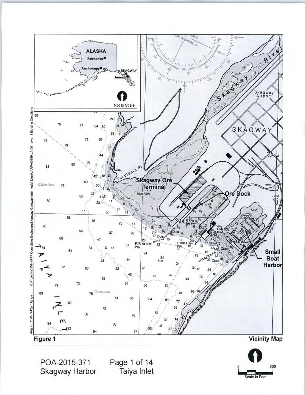
1 US Army Corps of Engineers Alaska District JUNEAU FIELD OFFICE Regulatory Division (1145) CEPOA-RD 8800 Glacier Highway, Suite 106 Juneau, Alaska Public Notice of Application for Permit PUBLIC NOTICE DATE: September 16, 2015 EXPIRATION DATE: October 15, 2015 REFERENCE NUMBER: WATERWAY: POA Taiya Inlet Interested parties are hereby notified that a Department of the Army permit application has been received for work in waters of the United States as described below and shown on the enclosed project drawings. Comments on the described work, with the reference number, should reach this office no later than the expiration date of this Public Notice to become part of the record and be considered in the decision. Please contact Matthew Brody at (907) , or by at Matthew.T.Brody@usace.army.mil if further information is desired concerning this notice. APPLICANT: Scott Hahn Municipality of Skagway P.O. Box 415 Skagway, Alaska AGENT: Chad Gubala Gubala Consulting Elliot Street Whitehorse, Yukon Y1A6C4 Canada LOCATION: The project site is located within Section 14, T. 28 S., R. 59 E., Copper River Meridian; USGS Quad Map Skagway B-1; Latitude º N., Longitude º W.; in Skagway, Alaska. PURPOSE: The applicant s stated purpose is to redevelop the Skagway Ore Terminal through the demolition of existing in- and over-water infrastructure, environmental dredging of contaminated sediments, and construction of new shoreline infrastructure to -1-
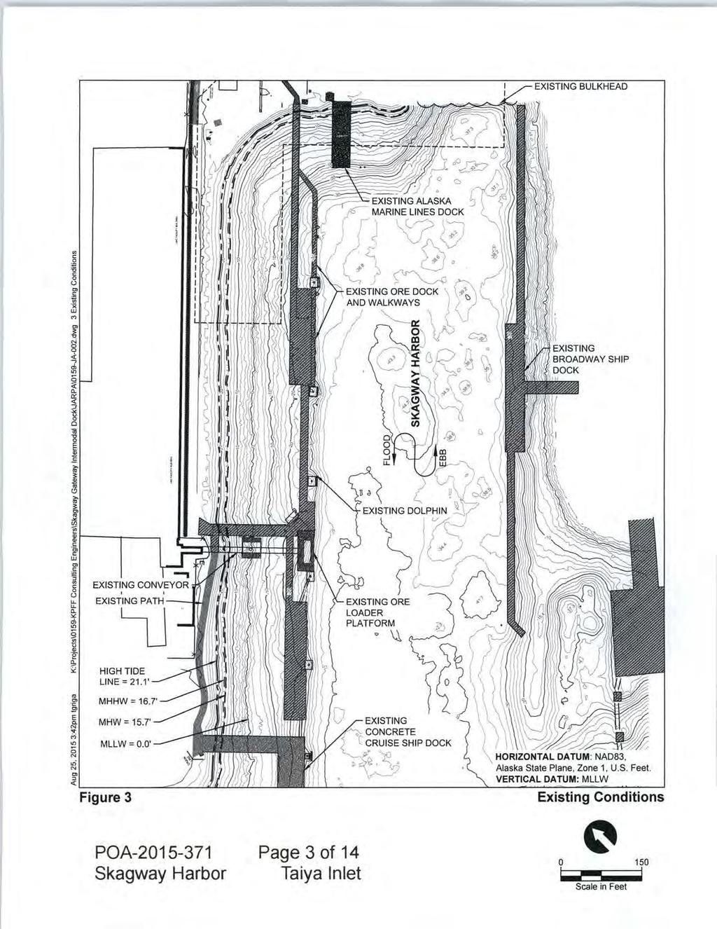
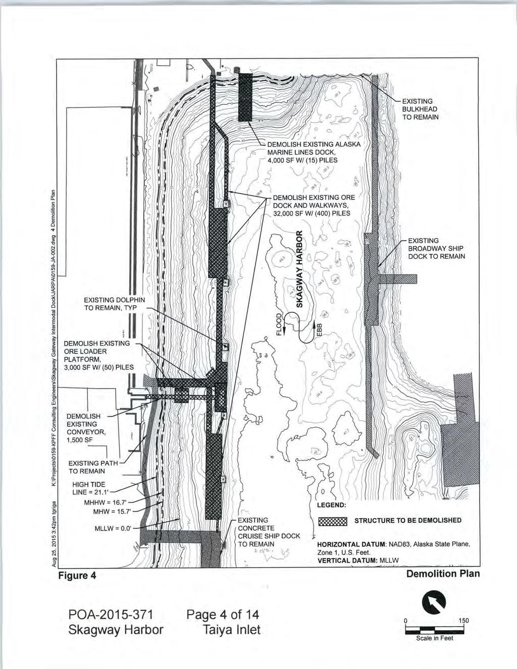
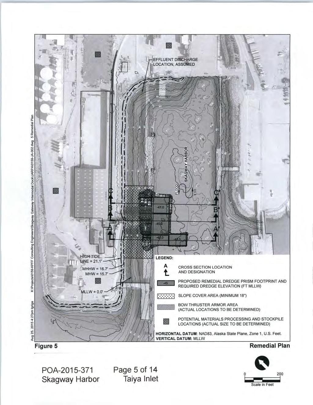
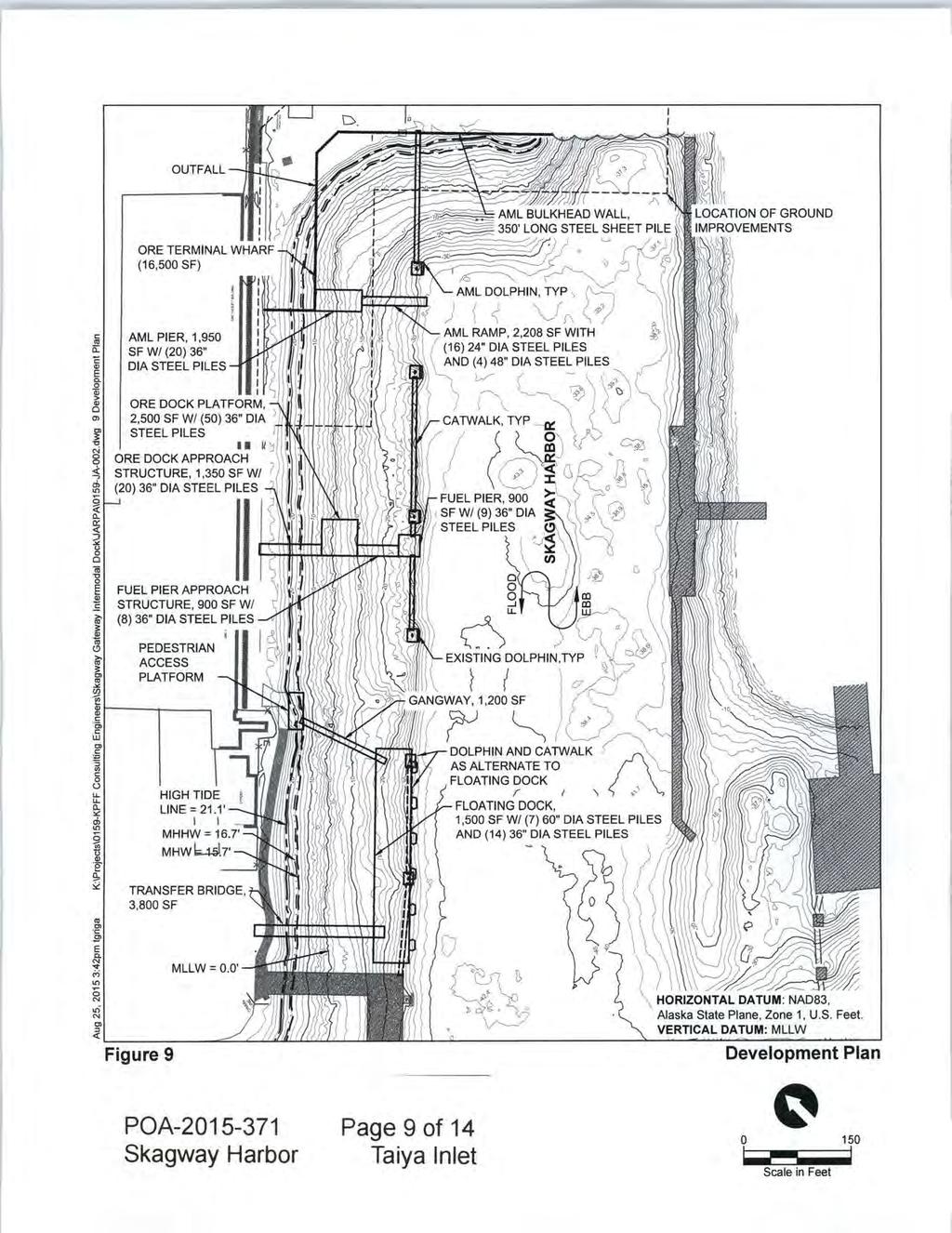
2 facilitate ongoing and new ore loading operations, accommodate a wider variety of vessels, and improve environmental conditions in the Skagway Harbor. PROPOSED WORK: The applicant is proposing to conduct the following work: Demolish and remove existing in- and over-water infrastructure, located in and over waters of the United States (U.S.), (seaward of the Mean High Water [MHW] feet above the 0.0 foot contour line) including: Alaska Marine Lines dock (4,000 square feet); Ore dock and Walkways (32,000 square feet); Ore loader platform (3,000 square feet); Ore conveyor (1,500 square feet); and approximately 465 creasote treated piles. Dredge 17,300 cubic yards of contaminated sediments from 62,245 square feet of waters below MHW. The contaminated sediment is estimated to contain 60 to 78 tons of lead, 0.05 to 0.06 tons of Mercury, and to tons of Polucuclic Aromatic Hydrocarbons (PAHs). The material would be removed from waters of the U.S., placed in an upland disposal area, and processed to remove/reduce contamination. Discharge 6,000 cubic yards of sorted sand and gravel mix with grain size ranging from coarse sands to quarry spalls, 18-inches deep, into 67,242 square feet of waters of the U.S. below the High Tide Line (HTL), (+21.1 feet above the 0.0 foot contour line) and MHW to cap the underlying material from exposure to the aquatic environment. Discharge 1,000 cubic yards of riprap ranging from 50 lbs to one ton each, into 15,992 square feet of waters of the U.S. below the HTL and MHW to armor the underlying material from disturbance of mooring vessels bowthrusters during moorage activities. Construct new infrastructure including a new sheet piling bulkhead and the placement of 4,000 cubic yards of sandy gravel behind the bulkhead within 4,135 square feet of Waters of the U.S. below the HTL. Construct a new ore terminal wharf, Alaska Marine Line (AML) pier, AML ramp, ore dock platform, ore dock approach, two catwalks, fuel pier, fuel pier approach, pedestrian access platform, gangway, floating dock, and a floating dock transfer bridge. All of these structures would be supported with 16 ea 24 inch steel piles, 121 ea 36- inch steel piles, 4 ea 48-inch steel piles, 7 ea 60-inch steel piles, and 6 dolphin structures. The new structures would occupy 28,102 square feet of waters of the U.S. seaward of the MHW reducing the existing over-water footprint by 12,498. All work would be performed in accordance with the enclosed plan, (sheets 1-14), dated August 25, APPLICANT PROPOSED MITIGATION: The applicant stated the following mitigation measures to avoid, minimize, and compensate for impacts to waters of the U.S. -2-
3 The Project is considered to be a self-mitigating project, as a major component of the project is environmental cleanup through remedial actions. The Project will result in significant improvements to the environmental conditions in Skagway Harbor through the cleanup of contaminated sediments and removal of existing creosote-treated structures. Two remedial actions are proposed to address sediment contamination: 1) Dredging of contaminated sediment in the vicinity of the Ore Dock loader; and 2) Placement of cover material on existing side slopes behind the Ore Dock. These two actions are proposed to address the contamination delineated through the sediment sampling program through dredging and minimize recontamination potential by placing cover material over the side slopes. In summary, the net environmental effects of the Project include the following: Remove up to 17,300 cubic yards (CY) of contaminated sediment from Skagway Harbor. The following are approximate mass estimates for lead, mercury and total polycyclic aromatic hydrocarbons (PAHs) that will be removed as part of Gateway remedial dredging adjacent to the existing ore loader location: o Lead: 60 to 78 tons o Mercury: 0.05 to 0.06 tons o Total PAHs: to tons Discharge up to 7,000 CY of clean cover materials to prevent recontamination. Remove approximately 350 creosote-treated timber piles from Skagway Harbor. Providing a net reduction of between 2,467 and 19,592 square feet of over-water cover through removal of existing in- and over-water infrastructure, depending on whether a concrete floating dock or moorage dolphins and catwalk option is chosen. Increasing the number of steel piles by a number ranging from 87 to 96, with associated sea floor impacts of 1,182.1 to 1,148.3 square feet, depending on whether a concrete floating dock or moorage dolphins and catwalk option is chosen. Based on the overall environmental betterments associated with constructing the Project, no additional mitigation actions are proposed. WATER QUALITY CERTIFICATION: A permit for the described work will not be issued until a certification or waiver of certification, as required under Section 401 of the Clean Water Act (Public Law ), has been received from the Alaska Department of Environmental Conservation. CULTURAL RESOURCES: The latest published version of the Alaska Heritage Resources Survey (AHRS) has been consulted for the presence or absence of historic properties, including those listed in or eligible for inclusion in the National Register of -3-
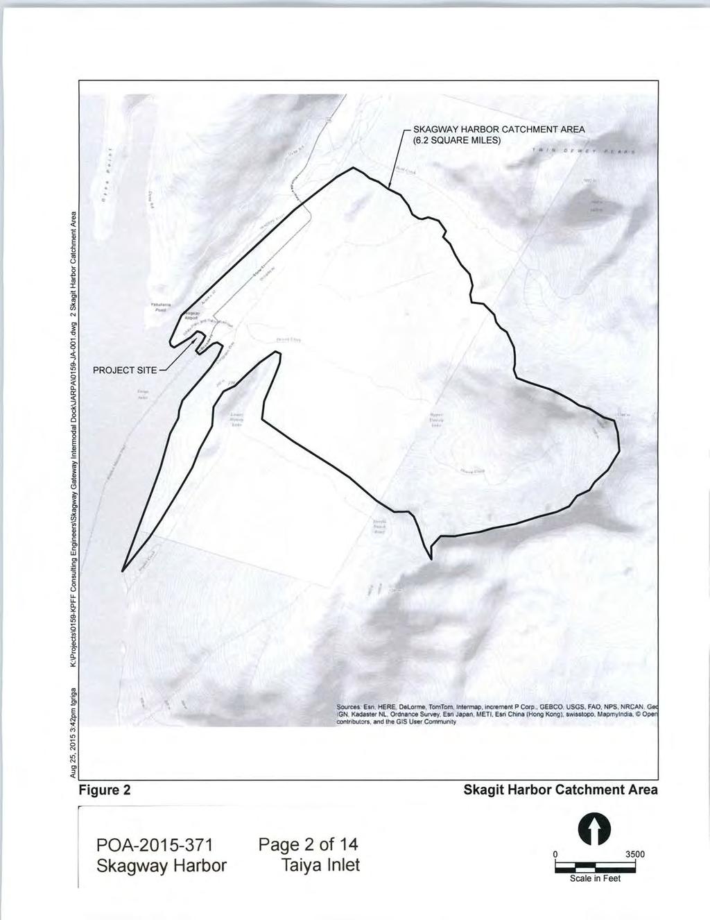
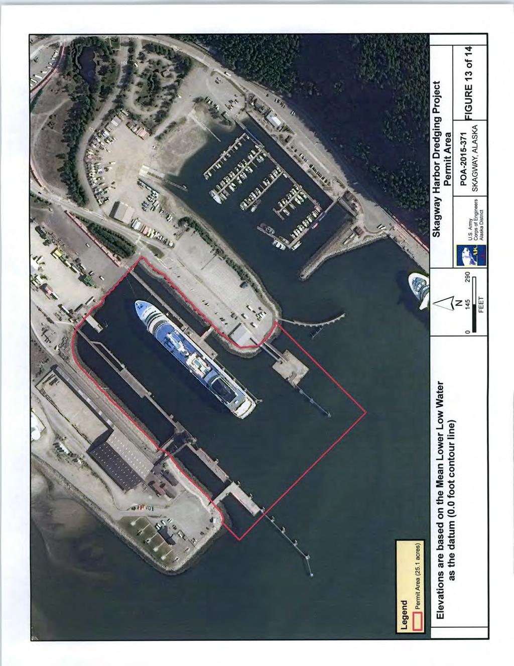
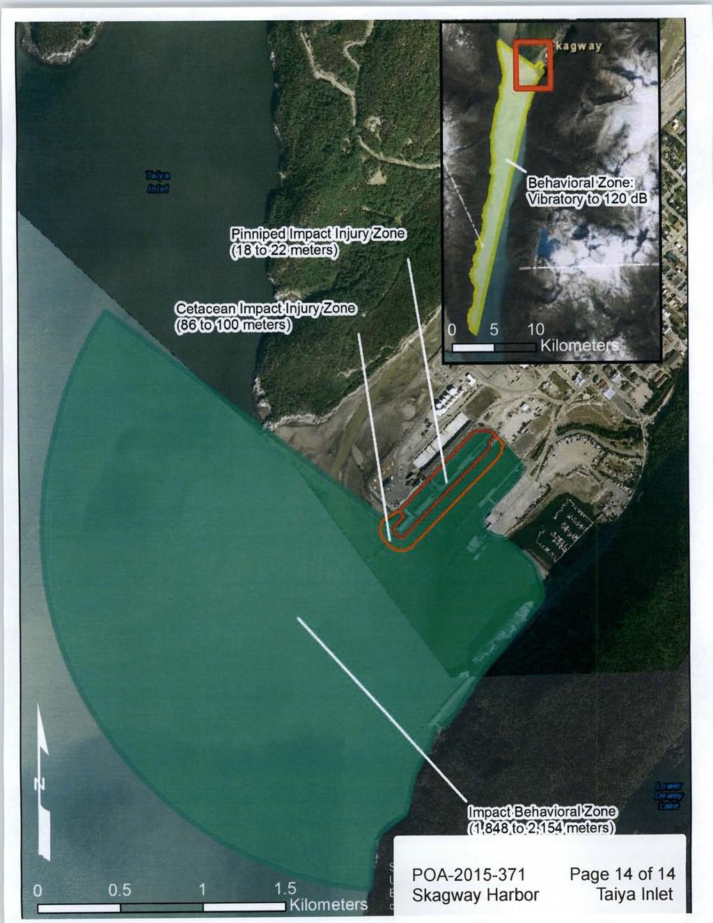
4 Historic Places. We have defined our scope of analysis under Appendix C of 33 CFR 325 (permit area) to be a 25.1 acre area of waters of the U.S. that would be subject to work associated with the applicants proposal. (See plans page 13 of 14) There is a registered or eligible property in the vicinity of the worksite. It has been designated SKG Skagway & White Pass Historic District which is a listed National Historic Landmark. While the project would be within the boundary of the Skagway & White Pass Historic District, there are no known historic resources within the permit area. The Corps of Engineers (Corps) has determined the proposal would have no effect to the property based on the nature of the activity and absence of historic resources within the permit area. The Corps is requesting concurrence from the State Historic Preservation Officer (SHPO) and the National Park Service. ENDANGERED SPECIES: The project area is within the known or historic range of the Steller Sea Lion Eumetopias jubatus and Humpback Whale Megaptera novaeangliae. The Corps has defined the ESA Action Area as the area where noise generated by the proposed project during construction may affect ESA-listed species and is depicted on page 14 of 14. We have determined the described activity May Affect, Not Likely to Adversely Affect the threatened or endangered Steller Sea Lions and the Humpback Whales. We have initiated the appropriate consultation procedures under section 7 of the Endangered Species Act with the National Marine Fisheries Service. We have designated Gubala Consulting, represented by Chad Gubala, as our non-federal representative to conduct section 7 consultation. The Corps remains responsible for the content of the assessment and for the findings of effect. Any comments they may have concerning endangered or threatened wildlife or plants or their critical habitat will be considered in our final assessment of the described work. ESSENTIAL FISH HABITAT: The Magnuson-Stevens Fishery Conservation and Management Act, as amended by the Sustainable Fisheries Act of 1996, requires all Federal agencies to consult with the National Marine Fisheries Service (NMFS) on all actions, or proposed actions, permitted, funded, or undertaken by the agency, that may adversely affect Essential Fish Habitat (EFH). The project area is within the known range of the : Coho (Oncorynchus kisutch), Chum (Oncorynchus keta), Pink (Oncorynchus gorbushca), Sockeye (Oncorynchus nerka), and Chinook Salmon (Oncorynchus tshawytscha). The Corps has determined the described activity may adversely affect 3.32 acres of EFH for the following species: Coho (Oncorynchus kisutch), Chum (Oncorynchus keta), Pink (Oncorynchus gorbushca), Sockeye (Oncorynchus nerka), and Chinook Salmon (Oncorynchus tshawytscha). The proposed project location is nearshore shallow water habitat primarily for adult and juvenile salmon migration, as these waters provide refuge -4-
5 from predators and opportunity to rest. The proposed project would involve pile driving, dredging, and filling activities, which may increase the potential for injury or mortality to salmon from pressure waves generated from pile driving, elevation of suspended particulates within the water column, and/or loss of habitat. This Public Notice initiates EFH consultation with the NMFS. Any comments or recommendations they may have concerning EFH will be considered in our final assessment of the described work. TRIBAL CONSULTATION: The Alaska District fully supports tribal self-governance and government-to-government relations between Federally recognized Tribes and the Federal government. Tribes with protected rights or resources that could be significantly affected by a proposed Federal action (e.g., a permit decision) have the right to consult with the Alaska District on a government-to-government basis. Views of each Tribe regarding protected rights and resources will be accorded due consideration in this process. This Public Notice serves as notification to the Tribes within the area potentially affected by the proposed work and invites their participation in the Federal decision-making process regarding the protected Tribal right or resource. Consultation may be initiated by the affected Tribe upon written request to the District Commander during the public comment period. PUBLIC HEARING: Any person may request, in writing, within the comment period specified in this notice, that a public hearing be held to consider this application. Requests for public hearings shall state, with particularity, reasons for holding a public hearing. EVALUATION: The decision whether to issue a permit will be based on an evaluation of the probable impacts, including cumulative impacts of the proposed activity and its intended use on the public interest. Evaluation of the probable impacts, which the proposed activity may have on the public interest, requires a careful weighing of all the factors that become relevant in each particular case. The benefits, which reasonably may be expected to accrue from the proposal, must be balanced against its reasonably foreseeable detriments. The outcome of the general balancing process would determine whether to authorize a proposal, and if so, the conditions under which it will be allowed to occur. The decision should reflect the national concern for both protection and utilization of important resources. All factors, which may be relevant to the proposal, must be considered including the cumulative effects thereof. Among those are conservation, economics, aesthetics, general environmental concerns, wetlands, cultural values, fish and wildlife values, flood hazards, floodplain values, land use, navigation, shore erosion and accretion, recreation, water supply and conservation, water quality, energy needs, safety, food and fiber production, mineral needs, considerations of property ownership, and, in general, the needs and welfare of the people. For activities involving 404 discharges, a permit will be denied if the discharge that would be authorized by such permit would not comply with the Environmental Protection Agency's 404(b)(l) guidelines. Subject to the preceding sentence and any other applicable guidelines or criteria (see Sections and 320.3), a permit will be granted unless the District Commander determines that it would be contrary to the public interest. -5-
6 The Corps of Engineers is soliciting comments from the public; Federal, State, and local agencies and officials; Indian Tribes; and other interested parties in order to consider and evaluate the impacts of this proposed activity. Any comments received will be considered by the Corps of Engineers to determine whether to issue, modify, condition or deny a permit for this proposal. To make this decision, comments are used to assess impacts on endangered species, historic properties, water quality, general environmental effects, and the other public interest factors listed above. Comments are used in the preparation of an Environmental Assessment and/or an Environmental Impact Statement pursuant to the National Environmental Policy Act. Comments are also used to determine the need for a public hearing and to determine the overall public interest of the proposed activity. AUTHORITY: This permit will be issued or denied under the following authorities: (X) Perform work in or affecting navigable waters of the United States Section 10 Rivers and Harbors Act 1899 (33 U.S.C. 403). (X) Discharge dredged or fill material into waters of the United States Section 404 Clean Water Act (33 U.S.C. 1344). Therefore, our public interest review will consider the guidelines set forth under Section 404(b) of the Clean Water Act (40 CFR 230). Project drawings and a Notice of Application for State Water Quality Certification are enclosed with this Public Notice. Enclosures District Commander U.S. Army, Corps of Engineers -6-
7 STATE OF ALASKA DEPT. OF ENVIRONMENTAL CONSERVATION DIVISION OF WATER 401 Certification Program Non-Point Source Water Pollution Control Program BILL WALKER, GOVERNOR DEPARTMENT OF ENVIRONMENTAL CONSERVATION WQM/401 CERTIFICATION 410 WILLOUGHBY AVENUE JUNEAU, ALASKA PHONE: (907) /FAX: (907) NOTICE OF APPLICATION FOR STATE WATER QUALITY CERTIFICATION Any applicant for a federal license or permit to conduct an activity that might result in a discharge into navigable waters, in accordance with Section 401 of the Clean Water Act of 1977 (PL95-217), also must apply for and obtain certification from the Alaska Department of Environmental Conservation that the discharge will comply with the Clean Water Act, the Alaska Water Quality Standards, and other applicable State laws. By agreement between the U.S. Army Corps of Engineers and the Department of Environmental Conservation, application for a Department of the Army permit to discharge dredged or fill material into navigable waters under Section 404 of the Clean Water Act also may serve as application for State Water Quality Certification. Notice is hereby given that the application for a Department of the Army Permit described in the Corps of Engineers Public Notice No. POA , Taiya Inlet, serves as application for State Water Quality Certification from the Department of Environmental Conservation. After reviewing the application, the Department may certify there is reasonable assurance the activity, and any discharge that might result, will comply with the Clean Water Act, the Alaska Water Quality Standards, and other applicable State laws. The Department also may deny or waive certification. Any person desiring to comment on the project, with respect to Water Quality Certification, may submit written comments to the address above by the expiration date of the Corps of Engineer s Public Notice. -7-
8
9
10
11
12
13
14
15
16
17
18
19
20
21