April 11, Kimberly Prillhart Planning Director Resource management Agency County of Ventura 800 South Victoria Avenue Ventura, CA 93009
|
|
|
- Augusta Moore
- 5 years ago
- Views:
Transcription
1 April 11, 2012 Kimberly Prillhart Planning Director Resource management Agency County of Ventura 800 South Victoria Avenue Ventura, CA RE: April 12, 2012 Hearing on Mosler Rock- Ojai Quarry Reclamation Plan Compliance Amendment ( RPCA ) Dear Ms. Prillhart, I am writing to express Santa Barbara Channelkeeper s (Channelkeeper) concerns regarding the proposed approval of Mosler Rock- Ojai Quarry s Reclamation Plan Compliance Amendment. Channelkeeper is a 501 c(3) non- profit organization that works to protect and restore the Santa Barbara Channel and its watersheds including the Ventura River watershed where we have conducted extensive water quality monitoring since In 2006, Channelkeeper became highly involved in monitoring and documenting water quality and habitat impacts in North Fork Matilija Creek resulting from operations conducted at the Ojai Quarry. Since that time we have communicated our concerns with local, State, and Federal agencies as well as with the owner of the Ojai Quarry himself in an effort to eliminate existing impacts. While managers of the Ojai quarry have taken certain actions to address our many concerns, we believe that significant impacts to North Fork Matilija Creek and Federally Endangered Steehead Trout continue to occur, in particular due to sediment contaminated stormwater runoff. Conditions Requiring Development of a Subsequent EIR Exhibit 21 of the County s staff report outlines its findings regarding requirements to revise the project s EIR. The county lists the conditions described in Section of the CEQA Guidelines, which require the preparation of a Subsequent EIR. We believe that the project clearly meets some of these conditions, and we therefore strongly disagree with the County s finding that no additional CEQA review should be required. Condition 1 requires a Subsequent EIR if: Substantial changes are proposed in the project which will require major revisions of the previous EIR due to the involvement of new significant environmental effects or a substantial increase in the severity of previously identified significant effects; The applicant wishes to seek approval for the inclusion of a rock crusher for the proposed project machinery list. This piece of machinery will likely produce a large volume of fine sediment by- product with the potential to impact North Fork Matilija Creek if it is not
2 contained and disposed of properly. We believe this addition is a substantial change to the project, which should be assessed in a Subsequent EIR. Condition 2 requires a Subsequent EIR if: Substantial changes occur with respect to the circumstances under which the project is undertaken which will require major revisions of the previous EIR due to the involvement of new significant environmental effects or a substantial increase in the severity of previously identified significant effects; As the County has identified, the Southern California steelhead trout (Oncorhynchus mykiss) was federally listed as an Endangered Species in 1997 since the project s EIR was certified. North Fork Matilija Creek, which the project discharges to, is identified as Critical Habitat for this species. This designation means that project impacts may result in a take of an Endangered Species, thereby resulting in a substantial increase in the severity of biological and sediment impacts previously identified, thereby requiring preparation of a Subsequent EIR. Condition 3 also requires a Subsequent EIR if: New information of substantial importance, which was not known and could not have been known with the exercise of reasonable diligence at the time the Planning Director/Planning Comission/Board of Supervisors certified the previous EIR, shows any of the following: b. Significant effects previously examined will be substantially more severe than shown in the previous EIR Clearly the designation of Southern California steelhead trout as a federally listed Endangered Species is new information of substantial importance not known at the time of adoption, resulting in substantially more severe impacts than were previously identified in the EIR. It should be noted that steelhead trout inhabit North Fork Matilija Creek in fact, and not only in designation as has been documented by multiple private and public agency biologists. Attachment A shows recent photographs of a steelhead redd recently discovered directly downstream of the Ojai Quarry underneath Matilija Road bridge. Additionally, it has been made abundantly clear that the mitigation measures (1 5) identified in the EIR to address impacts to Biological and Sediment impacts are not even minimally effective to reduce impacts to a less than significant level. We strongly disagree with the following statement made by the County (Exhibit 21, Page 4, Paragraph 1), Further, the biological mitigation measures discussed above [in the 1993 EIR] will continue to be executed on the site. The implementation of the mitigation measures reduced the project- specific and cumulative impacts to vegetation/plant communities, wildlife habitat, sensitive resources and sedimentation to a level less than significant. This later statement has over the last 18 years been demonstrated to be patently false. This fact is demonstrated through: Years of water quality monitoring conducted by Santa Barbara Channelkeeper including monitoring conducted after increased efforts to control sediment pollution were undertaken by the owner (Attachment C)
3 Repeated intervention by the Los Angeles Regional Water Quality Control Board, which has issued multiple Notices of Violation and a Cleanup and Abatement Order to the Quarry for stormwater pollution impacts Intervention by National Marine Fisheries Service to compel the Ojai Quarry to develop more effective sediment management practices The Ojai Quarry s own Annual Report (Attachment B), which indicates that discharge from the Ojai Quarry contained total suspended solids (sediment) at concentrations of 1220 mg/l. This level is over 12 times in exceedence of the Industrial Permit benchmark (100 mg/l) indicating that Best Management Practices are NOT minimizing sediment concentrations to a level that is not significantly impactful. As demonstrated, it is clear that significant effects that were previously examined have turned out to be substantially more severe than shown in the previous EIR. This condition therefore mandates that a Subsequent EIR be developed before the Amendment is approved. As a final note, we also do not agree with the following statement (Exhibit 21, page 3, paragraph 4), While the [North Fork] Matilija Creek runs adjacent to the project site along the western mining boundary, the proposed project will not impact the creek as the new reclamation areas are located on the eastern portion of the project site away from the creek. Channelkeeper notes that the new reclamation areas are all in fact located up- slope of North Form Matilija Creek, and the gradient of the land will carry all pollutants associated with the project to the creek itself regardless of the site s east/west orientation. For the reasons stated above, Channelkeeper finds that the Planning Commission has no other legal option but to deny approval of the proposed Amendment until a Subsequent EIR is developed, which adequately assesses impacts to endangered species, critical habitat, and water quality in North Fork Matilija Creek. Thank you for your consideration, Ben Pitterle Watershed Programs Director


4 Attachment A Steelhead trout redd located directly downstream of the Ojai Quarry underneath the Matilija Road Bridge. Note accumulated fine sediment surrounding nest. Photo: Paul Jenkin March 21, 2012 Steelhead trout eggs located directly downstream of the Ojai Quarry underneath the Matilija Road Bridge. Photo: Paul Jenkin March 21, 2012
5 Attachment B Ojai Quarry Annual Report for Storm Water Discharges Associated with Industrial Activities
6 i: alscience ~Environmental :5 aboratories, Inc. Analytical Report Page 2 of 7 Environmental Resolutions, Inc Telephone Rd, Suite 916 Ventura. CA Date Rece ived: Work Order No: 12120/ Project: Ojai Quarry Page 1 of 1 Lab Sample Number Date Client Sample Number Collected Matrix I SW l /10 Aqueous Parameter ~ RL OF Q.lgJ Units Date ~ Method Prepared Analvzed HEM: 011 and Grease NO 1.0 mgll /10 EPA 1664A Specific Conductance urnhcs/cm N/A 12120/10 SM 2510 B Sands. Total Suspended mgll 12124/ /10 SM I Method Blank N1A Aqueous Parameter Results RL OF Q.!ml Units Dale Oate Method ~ ~ HEM: 011 and Grease NO 1.0 mgl 12123/ EPA 1664A Sonds. Total Suspended NO 1.0 mgll M I RL - ReportingUm~. OF Dilution FaClOr. Qual - Qualifiers ~ 7440 lincoln Way, Garden Grove, CA TEL:(714) FAX: (714)
7 Attachment C Santa Barbara Channelkeeper Ojai Quarry Observation and Sample Result Log Rainy Season
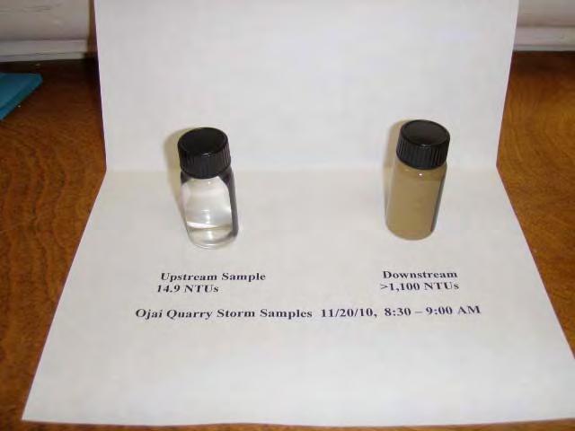
. Upstream of slide area and upper settling basin. Turbidity: 14.")
8 Ojai Quarry Observation and Sample Result Log Rainy Season Compiled by Ben Pitterle, Santa Barbara Channelkeeper November 20, :30 AM 9:00 AM (Storm) Following approximately 1.88 inches of rainfall on November 19 th based on Ventura County daily rainfall data at Station 134B (Matilija Dam). Upstream of slide area and upper settling basin. Turbidity: 14.9 NTUs TSS: 36 mg/l


9 Slide area. Failing silt fence. No apparent runoff seeping through or over basin slope. Lower settling basin discharge.


10 Discharge from pipe seeping out of rocks below settling basin outlet and flowing into creek. North Fork Matilija Creek below discharge. Turbidity: >1,000 NTUs (exceeded MDL of turbidimeter) TSS: 1560 mg/l
11
 Lower settling basin.")
12 December 4, 2010 Approximately 12 days since last significant precipitation event, which occurred between November (2.05 inches at Ventura County Station 134B Matilija Dam) Lower settling basin. Full of water and sediment.
.")
13 December 18 th, :15 AM 11:30 AM (Storm) Following approximately 2.2 inches of rainfall on December 17 th based on Ventura County daily rainfall data at Station 134B (Matilija Dam). Creek upstream of Quarry Turbidity: 1.86 NTUs TSS: 1.6 mg/l

.")
14 Stream Bank at upper settling basin. Coir matting and rolls in place. No apparent runoff at time of photograph. Lower settling basin and discharge to creek Turbidity: 1,540 NTUs (Note: turbidity of sample exceeded maximum detection limit of turbidity meter (1,100 NTUs). Reported turbidity is based on 1:10 sample dilution.) TSS: 998 mg/l

15 Upper settling basin runoff seeping through gravel and cobble and flowing under highway 33 overpass to creek

16 Creek downstream of quarry and lower settling basin runoff Turbidity: 22.9 NTUs TSS: 18 mg/l

17 January 10, :30 PM New rock slide immediately upstream of upper settling basin

18 Stream bank at upper settling basin. Failed BMPs - coir rolls, matting, and cobble dissipaters.

19 Erosion and BMP failure

20 Significant erosion of stream bank at upper settling basin is evident.


21 Lower settling basin is full of sediment Lower settling basin outlet clogged with sediment