Moving from EBSAs to a protected area network: Framework Considerations and Progress Challenges in Canada s Pacific waters
|
|
|
- Zoe Rice
- 5 years ago
- Views:
Transcription
1 Moving from EBSAs to a protected area network: Framework Considerations and Progress Challenges in Canada s Pacific waters Glen Jamieson Fisheries and Oceans Canada Nanaimo, BC
2 Drivers for Implementation of an Ecosystem Approach to Fisheries Management (EAFM) in Canada Domestic: Increase in our knowledge of the connection between ecosystem dynamics and fisheries resources Increasing pressure from ENGOs Legal requirements: Oceans Act, Species at Risk Act,, Bill C-32 C (Fisheries( Act) International: UNFA; 2002 Johannesburg Conference on Sustainable Development; FAO F code of conduct 2006 UN General Assembly Resolution on Sustainable Fisheries FAO Draft Guidelines on the Management of Deep Sea Fisheries NAFO efforts to protect Vulnerable Marine Ecosystems, e.g. measures to protect seamounts. Market Pressure: ENGOs increasingly effective in influencing seafood buyers/retailers, e.g. recent Greenpeace campaign Increasing demand from consumers for eco-friendly seafood products The adoption of an ecosystem approach is an important element of the MSC certification process Action: DFO is committed to the full implementation of EAFM to help h ensure the long term sustainability of fisheries resources and the health, productivity and diversity of marine ecosystems.
3 EAFM Elements EAFM takes into considerations the impacts of fishing on all of the components of the aquatic ecosystem including populations, communities and habitat, and their linkages, as well as the impacts of the state of the ecosystem on the state of the fishery resource. EAFM has three primary elements: Productivity Biodiversity Habitat
4 Productivity Objective: To establish clear rules for the management of fisheries that support healthy and productive fish populations. Issues and Actions: A Fishery Decision-Making Framework Incorporating the Precautionary Approach A Precautionary Framework has been developed that provides guidelines for the establishment of clear reference points and decision rules for the t management of fisheries. ( eng.htm) Consideration of the Important Role of Forage Species A Policy has been developed that provides guidelines for the responsible management of these important members of marine ecosystems ( Consideration of the Important Role of Top Predators (work underway) Options are currently being considered for the future development t of management tools to address the important role of these members of marine ecosystems
5 Biodiversity Objective: To manage fisheries in a manner that minimizes the impact of fishing on marine biodiversity. Issues and Actions: Protecting Species At Risk (SARA) (ongoing work) Fisheries managers will continue to work with the SARA Secretariat at to consider the potential impact of fisheries on listed species and to identify ify any necessary management measures Effective Management of Incidental Catch (work underway) Options for a national strategy to address incidental catch are currently under consideration; some policy established, e.g. A Policy Framework for the Management of Fisheries on... Reducing Incidental Catch of Seabirds irds in Longline Fisheries Addressing the Impact of Lost Fishing Gear (future initiative) Options are currently being considered for the future development t of management tools to address lost fishing gear and its impact on marine ecosystems
6 Habitat Objective: To manage fisheries in a manner that minimizes their impacts on marine habitat. Issues and Actions: Minimizing the Impact of Fishing on Sensitive Benthic Areas A Policy has been developed that provides guidelines to minimize the impacts of fishing on sensitive benthic areas. ( Development of Risk Assessment Model for Fishing Activity (work underway) Fisheries managers are currently developing a risk assessment framework that will be used to determine likely risk of fishing gear on ecosystem em features These actions compliment another conservation initiative by the Federal Government, namely the development of a network of Fisheries and Oceans Canada s s Marine Protected Areas and Parks Canada s s National Marine Conservation Areas.
7 Federal Marine Protected Areas Strategy (2005) Set the foundation for developing a marine protected areas network in Canada and aims to increase the ecological effectiveness and connectivity between individual marine protected areas in an effort to conserve and protect the structure and function of marine ecosystems. Within the context of the World Summit on Sustainable Development commitment, one objective is to complete a representative network by 2012.
8 How Canada s s network of marine protected areas will be built 1) to ensure that progress on the network continues, individual departments and agencies with marine protected area mandates will move forward [independently] in establishing areas that have previously been identified as candidate sites in accordance with their mandates and policies. 2) At the same time, collective planning efforts will be undertaken within the context of broader ocean planning initiatives or other strategic planning opportunities to identify: 1. a suite of sites that may be added to the network in the future or 2. which may require the application of additional conservation measures outside the purview of marine protected area programs.
9 Stages in Marine Area Evaluations Identification of ecologically significant areas within the context of DFO s integrated ocean management or other strategic planning initiatives, and areas that are representative of Parks Canada s marine regions. The Parks Canada initiative is moving ahead faster than DFO s. A commitment to protect marine biodiversity by implementing a network of marine protected areas (mpas)) requires specific considerations. A network differs from a set or system of mpas by implying there is some level of connectivity among designated mpas within a region. Establishment of a network can be summarised as a series of three steps.
10 MPA Establishment Phases 1. Compilation of data necessary for mapping habitats and species distributions within a particular region. Completion of this phase results in maps of representative areas, distinctive areas and species Important Areas (IAs( IAs), with the latter two used to determine Ecologically and Biologically Significant Areas (EBSAs( EBSAs). 2. Selection of a set of Areas of Interest (AOIs( AOIs), which together could constitute a mpa system. DFO has yet to prioritise objectives for this second phase. 3. Moving from a set of AOIs to determining boundaries for a logical and defensible mpa network. This considers the weighting of socio- economic and cultural objectives to create an acceptable network of mpas that meet identified ecological goals whilst minimising disruption to socio-economic and cultural needs. This consultative phase has not yet begun in BC. This talk will thus focus on how proposed EBSAs have been identified on the continental shelf, and how EBSAs may be used.
11 EBSA Dimensions Evaluated based on a continuum of the following main dimensions: Uniqueness (Rarity) Aggregation Fitness Consequences Other dimensions Naturalness Resilience
12 Biological Considerations The spatial requirements in the context of EBSA dimensions should ideally be considered for all life stages of a species,, e.g. mating/spawning areas, larval locations, juvenile nursery areas, feeding locations, migration routes, etc. However, for many mobile, commercially harvested species, much of this information is poorly documented, if known at all. This makes achieving connectivity in a functional sense often difficult and sometimes impossible to assess and achieve,, and suggests that research on the spatial requirements for relevant species should be given a higher regional priority.

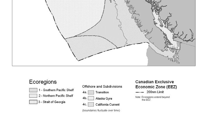
13 Canada s s Pacific Ecoregions

14 WCVI and SoG Important Area Examples Basking Shark Pollock Harbour Seal Coral

15 All species EBSAs overlaid on base map of PNCIMA.


16 PNCIMA, WCVI and SoG Overlaid IA layers PNCIMA WCVI and SoG


17 Strait of Georgia Ecoregion Oceanographic layers Draft EBSAs
 Sabine Channel between Lasqueti and Texada Islands, 5) Southern Gulf Islands, 6) Fraser River Estuary and Boundary Bay, and 7) Glass Sponge")
18 Draft EBSAs for the SOG, excluding River Mouths and Estuaries: 1) Discovery Passage Entrance, 2) Desolation Sound and Pendrell Sound, 3) Baynes Sound, 4) Sabine Channel between Lasqueti and Texada Islands, 5) Southern Gulf Islands, 6) Fraser River Estuary and Boundary Bay, and 7) Glass Sponge Reefs.
 Juan de Fuca Eddy, 5) Bottleneck: Barkley Sound and Alberni Inlet, and 6) Bottleneck: Juan de Fuca")
19 Draft EBSAs for the WCVI, excluding River Mouths and Estuaries: 1) Brooks Peninsula Jets, 2) Shelf Break, 3) Edges of Banks and Basins, 4) Juan de Fuca Eddy, 5) Bottleneck: Barkley Sound and Alberni Inlet, and 6) Bottleneck: Juan de Fuca Strait.


20 Proposed PNCIMA EBSAs 19 Draft PINCIMA EBSAs
21 EBSA Scale Issues In BC, suggested EBSAs represent about 50+% of the total area in each ecoregion. This is a relatively large percentage in comparison to other Canadian regions, but is argued to be appropriate because: 1. Pacific ecoregions are relatively small geogaphically,, and a minimum area is required to capture IAs for even moderately mobile species; 2. The biodiversity for all taxonomic groups is 5-10x 5 higher in BC waters than in Canadian Atlantic waters, meaning there are more species-specific specific spatial locations to be considered, and 3. Within each ecoregion, there is high oceanographic and bathymetric diversity, resulting in a large number of distinctive biological communities that need to be considered. In contrast, many habitats in Canada s s other oceans are huge and relativelu homogenous in comparison (e.g. Scotian Shelf and Grand Banks).


22 Scale differences between regions GOSLIM ESSIM
23 Utility of EBSAs 1. A data component in the determination of Conservation Objectives that will be used in assessing permitted human marine impacts and their scales. 2. Potential Areas of Interest (AOIs( AOIs) ) for consideration as locations for future MPAs,, i.e. to identify areas in which at least a portion of which will be proposed to have no direct human impacts, i.e., become no-take areas.
24 Conservation Objectives The First attempt at determining Conservation Objectives for EBSAs, ESSs, Depleted Species, etc. (red line) has been done. Ecological Objectives Needed science will be to determine appropriate indicators, references points, etc. (yellow line) A consultative initiative to determine Desirable Objectives will need to be undertaken. (white line) Conservations Objectives (biological) Indicators, reference points Desirable Objectives (socio-economic)
25 Possible Conservation VS Desirable Thresholds P r o p o r t i o n 1 Green Yellow Red Habitat carrying capacity Upper and lower desirable population size range Minimum science-based threshold 0 SBT LDT UDT Abundance
26 AOI Determination from EBSAs Protection of Unique Areas and particularly vulnerable habitats Sponge reefs Biogenic Structure long lived, slow-growing Coral and sponge communities Protection (minimisation of disturbance) of non- exploited life stages and/or non-commercial species Nursery/juvenile grounds Breeding colonies and pinniped haulouts Locations of endangered and threatened species (critical habitat)
27 Its All in the Details Precise AOI boundaries will need to be determined through extensive consultations with all interested parties, as in many cases, there may be both spatial and/or temporal options re boundary definitions. At the least, available biological data should be presented to stakeholders to rationalise any proposed MPA establishment, and the need to acquire relevant data may help in establishing future research priorities.
28 Summary 1. EBSA determination is the first marine spatial planning step in the determination of a network of functional MPAS. 2. EBSAs provide a rational basis for evaluation of AOIs and help in determining high priority areas. 3. However, in many cases, EBSAs themselves are either too large or their boundaries are too poorly defined to become AOIs in their entirety, which necessitates at a minimum: 1. consultation with relevant stakeholders and 2. possibly over the long term, additional research (adaptive management) to define the most effective and appropriate AOI boundaries from both conservation and socio-economic perspectives.