Forecast Informed Reservoir Operations for Groundwater Recharge Prado Dam
|
|
|
- Griffin Russell
- 5 years ago
- Views:
Transcription
1 Forecast Informed Reservoir Operations for Groundwater Recharge Prado Dam Greg Woodside Orange County Water District Bridging the Gap Conference January 29, 2019
2 Anaheim

3 Army Corps of Engineers & OCWD have long-standing Partnership in Prado Basin

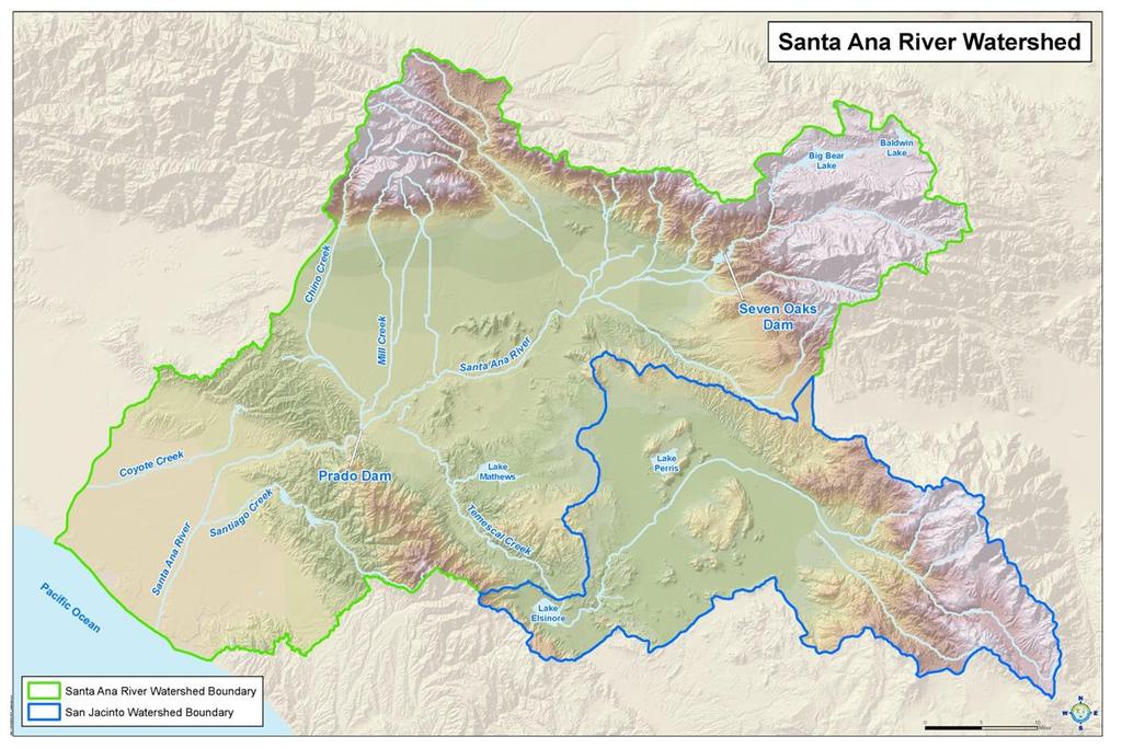
4 Starting about 11 miles downstream, OCWD recharges Santa Ana River water captured at Prado Dam
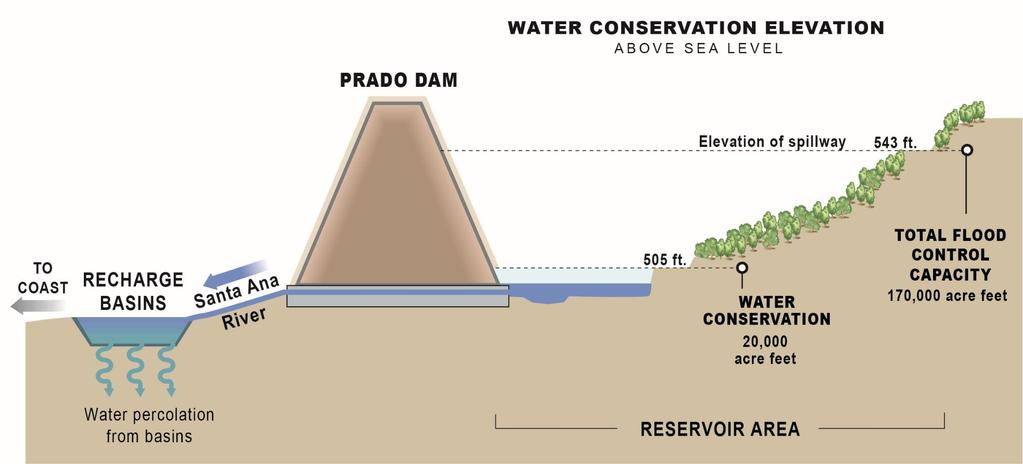
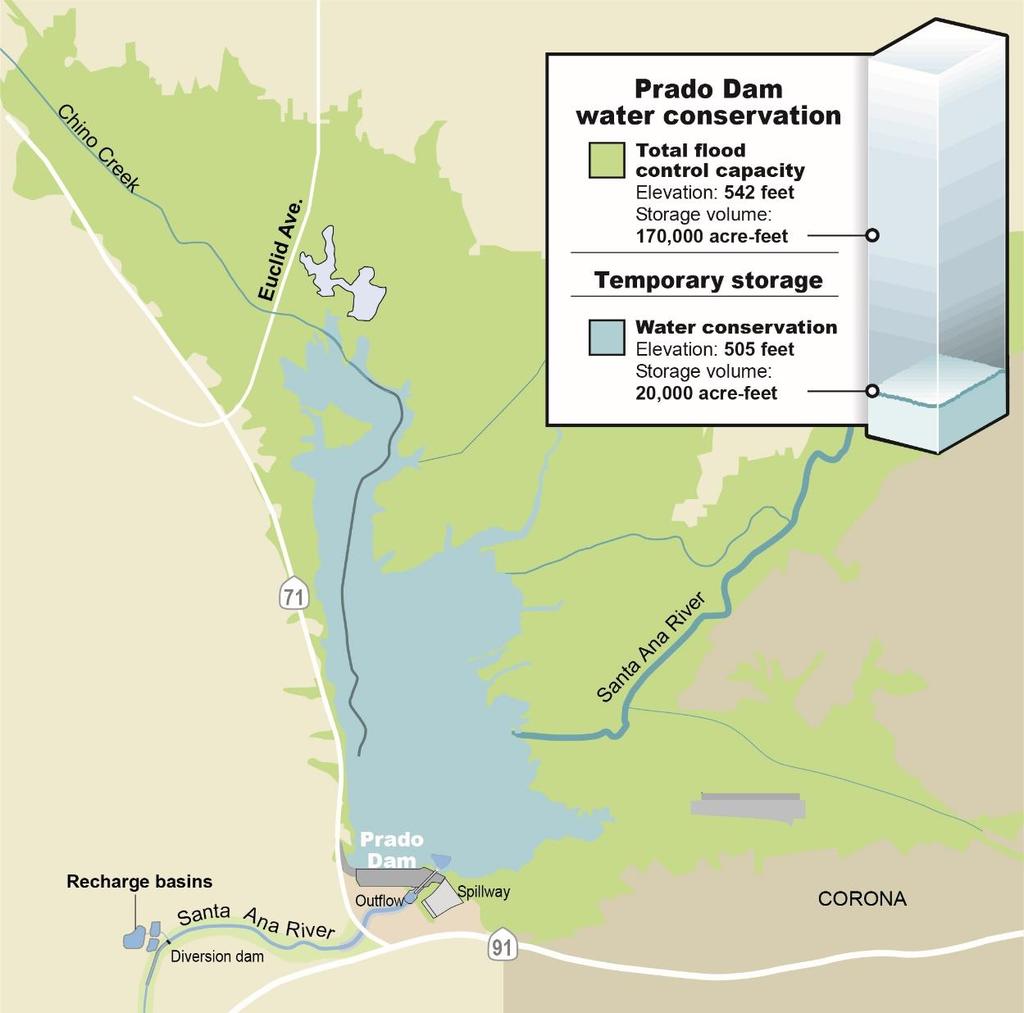
5 Summary of Prado Water Conservation through Time Year Flood Season Non-Flood Season 1969 revision to reservoir regulation schedule 490 ft 1990 update to water control manual 494 ft 1993 MOA 494 ft 505 ft 2006 MOA 498 ft 505 ft * Water captured up to these elevations is released at rate OCWD can capture it downstream
6 Key Features of Stormwater Capture at Prado Dam Primary purpose of Prado Dam is flood risk management Stormwater capture, aka water conservation is secondary purpose No dedicated water supply pool OCWD has no storage rights Stormwater held temporarily in buffer pool can be released by Corps at any time at their sole discretion
7 Key Features of Stormwater Capture at Prado Dam (cont.) Inflows increase very rapidly during rainfall events OCWD s downstream recharge capacity: 350 to 700 cfs Generally higher early in storm season In a wet year, recharge capacity declines due to recharge basin clogging from silt/clay carried by SAR water Have to maintain 350 cfs release rate per Biological Opinion from USFWS (depending on water surface elevation)
8 Natural Resource Management in Prado Basin

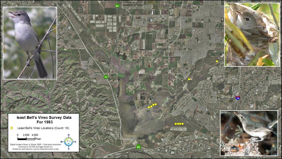
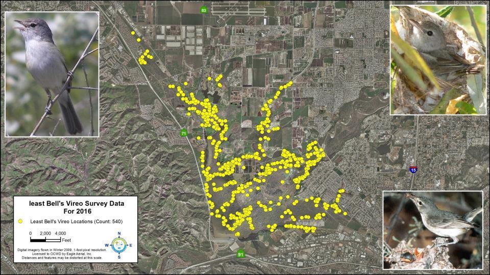
9 Prado Basin Resources OCWD owns 2,150 acres behind Prado Dam Endangered species habitat throughout Prado Basin (riparian habitat) OCWD implements programs to enhance native riparian habitat and control nonnative cowbird population 800 acres of mitigation areas
10
11
12 Efforts to Increase Stormwater Capture at Prado Temporary deviation to 505 feet in flood season approved by Army Corps in September 2018 Extends to February 2023 Permanent change to 505 feet in flood season being evaluated in Prado Basin Feasibility Study being conducted by Corps with OCWD as local sponsor
13
14

15 December 18, 2010

16 December 20, 2010 Note: 8 inches of rain in 6 days
17 Note: preliminary data Source: USACE, ,500cfs Inspection/Repair 100 cfs 5,000cfs
18 Note: preliminary data Source: USACE, 2017
19 February Event Precipitation (in) Inches Feb 6-Feb 11-Feb 16-Feb 21-Feb 26-Feb 8,000 7, ,000 5,000 Flow (cfs) 4,000 3,000 Inflow (cfs) Outflow (cfs) Water Surface Elevation 6,500 af of storage created Water Surface Elevation (ft msl) 2, , Feb 6-Feb 11-Feb 16-Feb 21-Feb 26-Feb 474
20 Source: USACE,

21 Source: NWS San Diego office,
22 Forecast Informed Reservoir Operations Using enhanced weather forecasting and runoff estimation tools to inform future reservoir operations Includes growing understanding of atmospheric river (AR) storms Following in footsteps of Lake Mendocino effort by Sonoma Water, Army Corps, Scripps and other agencies
23 FIRO Scoping Study Two phases Phase I Complete Formed Prado FIRO Steering Committee Create detailed FIRO Viability Assessment Work Plan Outline Begin Preliminary Technical Studies

24 FIRO Steering Committee chaired by Dr. Marty Ralph and Greg Woodside Includes staff from: USACE DWR National Weather Service Sonoma Water Orange County DPW USFWS
25 Phase II of Scoping Study Prado FIRO Steering Committee FIRO Viability Assessment Work Plan Plan and Execute FIRO Workshop Additional preliminary technical study Explore precipitation forecast skill Evaluate forecast lead time needed for FIRO at Prado Dam
26 Prado Dam FIRO Timeline Phase I: Scoping Study, Develop FIRO Viability Assessment Work Plan Outline Phase II: Conduct Technical Studies; Complete FIRO Viability Assessment Work Plan Phase III: Execute FIRO Viability Assessment Phase IV: Conduct FIRO at Prado Dam as part of Major Deviation Phase V: FIRO incorporated into Prado Dam Water Control Manual as permanent feature * 2025* *Phase IV/V timeline dependent on hydrology and completion of the Santa Ana River Mainstem Project.