Transitioning to an Enhanced Groundwater Management Framework in Alberta. Dan Palombi Alberta Geological Survey
|
|
|
- Elisabeth Sharon Griffin
- 5 years ago
- Views:
Transcription

1 Transitioning to an Enhanced Groundwater Management Framework in Alberta Dan Palombi Alberta Geological Survey

2 Alberta Water Demand
3 Water Use in Major River Basins Peace River Basin 5.8% 1.9% 9.0% 10.4% 26.3% 46.6% Water Well Use Drilling Use Municipal Use EOR Use MSHF Use In Situ Use Athabasca River Basin 6.4% Oil Sand Mining Use 80.2% 5.7% 7.7% 2.2% 4.1% 1.1% 0.4% Water Well Use In Situ Use EOR Use Drilling Use Municipal Use Bow River Basin MSHF Use Tony Lemay, AGS 85.7% 14.0% 6.6% 7.3% 0.1% 0.0% Irrigation Use Municipal Use Water Well Use EOR Use MSHF Use 3

")
4 Hydraulic Fracturing in Alberta Only oil and gas wells with multi-stage hydraulic fracturing since 2008 (left) Red dots show locations where drilling targets natural gas including deep shale formations in the Montney and Duvernay play areas Green dots show locations where drilling targets crude oil from conventional sandstone and carbonate formations Tony Lemay, AGS Above: Sub-basin water use for multiplestage hydraulic fracturing (2013)

5 Conservation: Oilfield Injection


6 Program Objectives Fresh and saline water focus Phase II Council of Canadian Academics, Phases of the Program I. Characterize the natural system: groundwater regime, aquifer maps, reports, and data sets II. Understand dynamics of groundwater systems: numerical models III. Develop decision-support tools for resource management, regulation, and policy development 6
7 Recent Advancements in Mapping Deep Regional Aquifers 1. Analytical method to examine the influence of production and injection operations on well-test analyses (e.g., Drill Stem Tests) Use for mapping natural and production-affected hydraulic head distributions for regional aquifers 2. Analytical method to account for variable density flow effects using the Water Driving Force (WDF) method Employ vector analysis to identify flow directions in regions where density-driven flow is important and can change the inferred magnitude and direction of flow 7
8 1. Examining the Influence of Production and Injection Cumulative Inference Index (CII) methodology can be implemented to identify production influences The methodology assumes that production influences are analogous to water-well testing principles; meaning the effect is directly proportional to an inference index, log (t/r 2 )** t is the length of time since production and r is distance (radial proximity) between a production well and the well where pressure was measured (e.g., DST) The CII index for a particular DST is the cumulative sum of inference indices for pumping/injection wells in the surrounding region ** Bruin and Hudson (1961), Tóth and Corbett (1986)

9 Depiction of CII Methodology
10 CII Required Data and Output Input DST test location and date Production well locations along with production start/end dates Search Radius Output Cumulative inference index (CII) Distance to the nearest well Number of wells within the radius (R) Longest production duration among the wells within the search radius

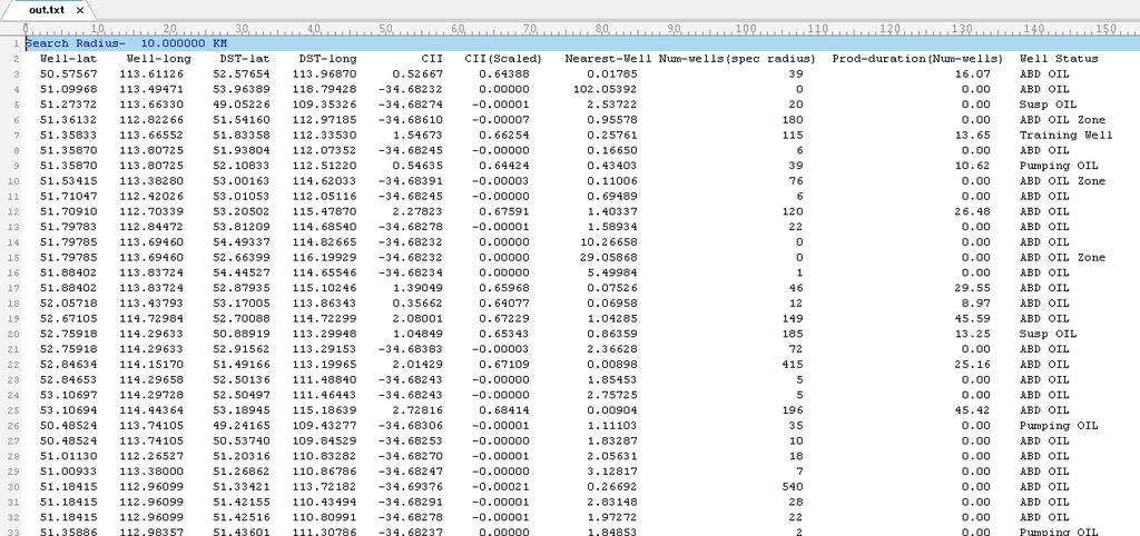
11 CII Code Results
12 2. Variable Density Effects: Water Driving Force Vector Fields Water Driving Force (WDF) is a function of: Pressure-related driving force Relative density Aquifer structural gradient


13 Implementing the WDF Salinity Pressure Input grids of: Structure top of underlying aquifer Hydraulic head Temperature Salinity Pressure Output Water driving force (resultant and magnitude) Methodology Structure Head Temperature Water density calculated from temperature, salinity and pressure grids (Chierici, 1994, equation of state) Resultant WDF calculated using the equation of previous slide Methodology implemented in Python and ArcMap is used for visualization


14 Example of WDF Python Code and Resultant Maps


15 Example of WDF Resultant Maps
16 AGS Regulatory Enhancement Targets for Non-Saline Groundwater Management Assist regulator(s) of the Water Act using groundwater mapping and numerical models to enhance authorization process: Evaluate groundwater authorizations Support a change from well by well (Q20) evaluations to cumulative impact based assessments Generate regional models to assess water-balance, drawdown, and yield forecasting Enable scenario modelling to evaluate future groundwater developments 16
 Natural (zero extractions) Recent (actual) Fully licensed 2.")
17 What Have Other Jurisdictions Done For Cumulative Effects? National Groundwater Modelling System (NGMS) in United Kingdom Capabilities includes: 1. Reference situation Historic (calibration) Natural (zero extractions) Recent (actual) Fully licensed 2. Scenarios (impacts of change) Groundwater extractions Surface water extractions and discharges Climate change (rainfall) 3. Output of Interest Absolute values and differences in: Surface water flows Hydraulic heads Water budgets 17
 More details in Paper No.")

18 Regional Groundwater Flow Models Taking a Nested-Scale Approach Sylvan Lake Management Model ESRD 3D representation of hydraulic heads (above) More details in Paper No Regional Model Local-scale groundwater management model nested within a regional groundwater model Nested predominantly refers to numerical boundary conditions (heads and fluxes) 18


19 Integration of Numerical Model In Delft-FEWS (Forecasting, Evaluation & Warning System) About Delft-FEWS: The software is free Any model can be linked to FEWS New displays can be added to the user interface Wide variety of data can be imported, displayed and used in the models New data can be added anytime Output can be automatically formatted and posted to a web server 19


20 Groundwater Model Displays in an Operational System (Delft-FEWS) 20
21 Summary Continued energy resource development is relying upon available water resources overprinted on existing water use across multiple sectors. Characterization of deep groundwater resources is becoming increasingly important as the Government of Alberta implements its Water Conservation Policy seeking to minimize freshwater use. As industry moves to utilize more saline water, a more comprehensive understanding of deep groundwater will be required to manage and allocate water resources in Alberta. Comprehensive strategies for water resource management are being evaluated and regulatory decision-support systems underpinned by numerical models have emerged as a potential path forward. We are seeking a scientific linkage between regulators, model developers, policy makers, and local stakeholders in order to devise an enhanced groundwater management framework focused on understanding cumulative effects of development. 21


22 Acknowledgments Steve Wallace, Andy Ridge Bennie Minnema, Edwin Welles & Peter Vermeulen Rolf Farrell, Mark Whiteman Jon Sweetman Ministry of Economic Affairs, Agriculture and Innovation, The Netherlands 22