Clallam County Shoreline Master Program (SMP) Update
|
|
|
- Walter Ralph Pitts
- 5 years ago
- Views:
Transcription
1 Title Level 1 Title Level 2 Clallam County Shoreline Master Program (SMP) Update Sekiu-Clallam Bay Regional Forum November 2, 2017

2 Clallam County Shoreline Master Program: In effect for Over 40 years, with nine revisions.


3 Shoreline Management Act Goals Encourage water-dependent & priority uses Protect natural resources Promote public access


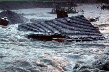
4 Increase protection of lives and property from flood, channel migration, landslide damage, and other environmental hazards Strait of Juan de Fuca
5 Authority Shoreline Management Act (RCW 90.58) Shoreline Master Programs Guidelines (WAC ) Shoreline Management Permit and Enforcement Procedures (WAC )

6 Steps to updating an SMP SEPA Environmental Review (October 2017) June , 2014, & June 2017 Updated Completed 2012 Completed 2011 Completed 2011
7 Draft SMP (Sept. 2017) Contents: Chap. 1: Introduction and Overview (e.g., Vision, Goals, Jurisdiction) Chap. 2: Shoreline Environmental Designations (SED) Chap. 3: Policies & Regulations for Specific Shoreline Uses & Development Chap. 4: Policies & Regulations for Shoreline Modifications Chap. 5: General Policies & Regulations Chap. 6: Shoreline Buffers & Vegetation Conservation Chap. 7: Critical Areas within Shoreline Jurisdiction Chap. 8: Mitigation and No Net Loss Chap. 9: Shorelines of Statewide Significance Chap. 10: Administrative Procedures Chap. 11: Definitions Exhibit A: Shoreline Environmental Designation (SED) Maps Exhibit B: Shoreline Permit Checklist
8 Shoreline Jurisdiction (See SMP Section 1.8) What Areas Are Subject To The Shoreline Master Program (SMP)?

9 Shoreline Master Program applies to: All 39 counties and more than 200 cities that have "shorelines of the state" Shorelines of the state include: Dickey Lake, 2006 All marine waters; Streams greater than 20 cubic feet feet per second mean annual flow; Lakes 20 acres or larger; Adjacent shorelands

10 Shorelands include: Lands within 200 feet of ordinary high water mark or floodway (where mapped), whichever greater. Associated Wetlands (e.g. wetlands in floodplain) River Deltas Up to the full extent of the 100-year floodplain (propose all) Critical area buffers** Hoko R. mouth, 2006 * *All lands necessary for buffers to protect critical areas (e.g., wetlands, landslide hazard areas, other non-smp streams) that are overlapping or otherwise coincident with shoreline jurisdiction.

11 Areas Covered by the SMP
12 Areas covered by the SMP


13 Area Covered by the SMP

14 Area Covered by SMP: Option to include lands necessary for buffers for critical areas.

15 Landslide Hazard Area--Critical Area Buffer Example 200 feet
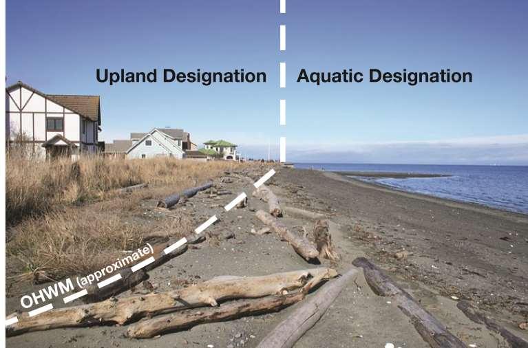
16 Area covered by Clallam Co. SMP Approximately 4.5% of County subject to Draft SMP Most marine areas to County/State jurisdictional line Port Angeles and Sequim have own SMP. Forks will consider adopting County SMP. National Park and Tribal Reservation/ Trust lands are excluded

17 General Map Showing Approximate Shoreline Jurisdiction (Does not show extent into marine waters)
18 Chapter 2- Shoreline Environmental Designations (SEDs)
19 What are Shoreline Environment Designations (SEDs)? Purpose: To provide a framework for tailoring policies and regulations to different shoreline segments based on their characteristics. Mapping: Each shoreline segment has a mapped SED based on classification criteria.
20 What are Shoreline Environment Designations (SEDs)? Management Policies Regulations Based on Assigned SED: Permitted, Conditional and Prohibited Uses and Developments Shoreline buffers Other standards Similar to zoning, but specific to the land and water areas subject to the SMP. New shoreline uses and development must still comply with County zoning and other applicable regulations.


21 Assigning Designations Vegetation & habitat Shoreline modifications Hazards Lot size & shape Future development potential Existing land use Shoreline Environment Designation Risk that development will affect functions
22 Shoreline Environmental Designations (SEDs) Existing Designations Natural Conservancy Rural Suburban Urban Proposed Designations Aquatic Natural Resource Conservancy Shoreline Residential -- Conservancy Shoreline Residential -- Intensive Marine Waterfront
23 Aquatic Designation Waterward of the ordinary high water mark (OHWM) of marine and freshwater water bodies (subject to the SMP) together with their underlying lands and their water column.
24
25 CLALLAM BAY-SEKIU URBAN GROWTH AREA (UGA) & VICINITY PROPOSED SHORELINE ENVIRONMENTAL DESIGNATIONS
26
27 Marine Waterfront (Sekiu Waterfront) Natural (Sekiu Point and West)

28 Marine Waterfront (SR 112 between Sekiu & Middle Point)

29 Marine Waterfront (SR 112 between Sekiu & Middle Point)

30 Marine Waterfront (Between Clallam Bay & Sekiu at Middle Point)

31 Marine Waterfront ( Between Clallam Bay & Sekiu at Middle Point)

32 Marine Waterfront (SR 112 Between Clallam Bay and Middle Point)

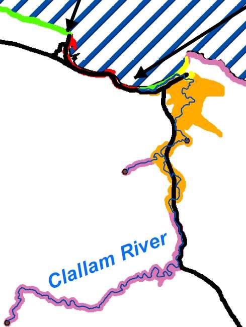
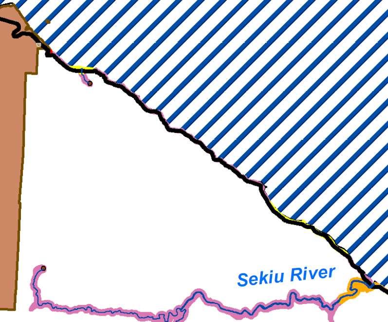
33 Natural (Clallam River and Beach Area) Shoreline Residential Conservancy (South-side River)

34 Natural (Clallam River and Beach Area) Shoreline Residential Conservancy (South-side River & Upstream Areas)
 Resource Conservancy (Slip Point and to")
35 Shoreline Residential-Intensive (Salt Air Street Area) Resource Conservancy (Slip Point and to East)
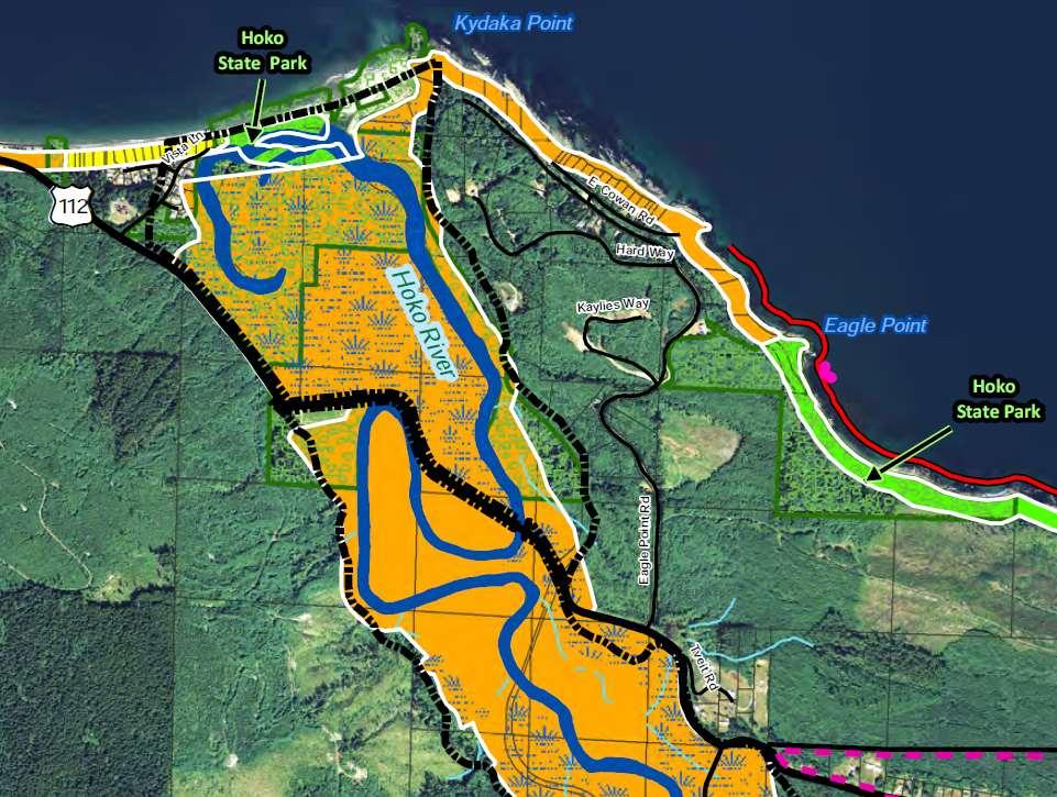
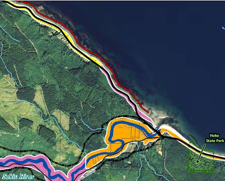
36 Shoreline Environmental Designations (SEDs) Hoko River and Tributary Area

37
38

39 Shoreline Residential - Intensive (Vista Drive, Hoko River)
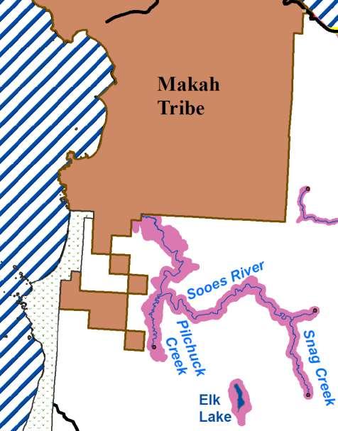
40 Shoreline Environmental Designations (SEDs) Sekiu River and Coastal Area Between Sekiu River and Makah Reservation
41 Makah Res.
42
 Resource Conservancy (West of Sekiu River along")
43 Shoreline Residential-Conservancy (East of Sekiu River & Upstream Areas) Resource Conservancy (West of Sekiu River along Coast)

44 Shoreline Residential-Intensive (SR 112 Approx. 1-mile west of Sekiu River)

45 Shoreline Residential-Intensive (SR 112 & Dawnsridge Rd, West of Sekiu River)

46 Resource Conservancy (Shipwreck Point and SR 112)

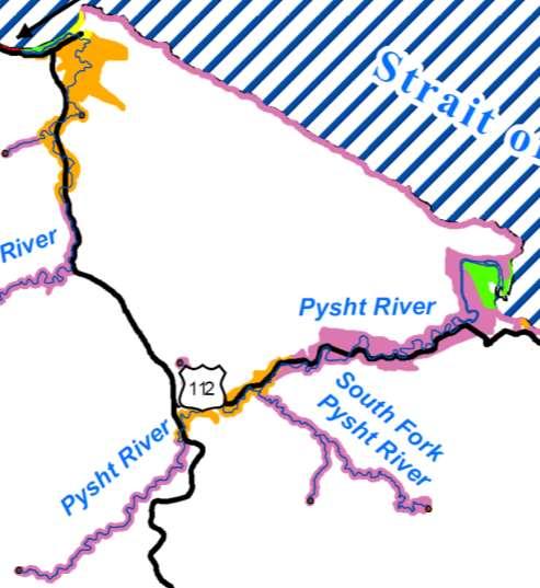
47

48 Shoreline Residential-Intensive (SR 112 & Bullman Creek)

49 Marine Waterfront (SR 112 & Snow Creek)
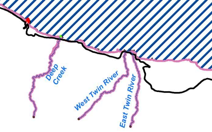
50

51
52 Shoreline Environmental Designations (SEDs) Pysht River Area
53

54 Resource Conservancy (Between Clallam Bay & Pysht River)

55 Resource Conservancy (Pillar Pt.)

56 Natural (Pysht River & Associated Wetlands)
 Resource Conservancy (East & West of")
57 Shoreline Residential-Conservancy (at Pillar Pt. County Park) Resource Conservancy (East & West of Park)
58

59 Marine Waterfront & Resource Conservancy (SR 112 & Jim Creek)

60 Natural & Resource Conservancy SED (Deep Creek)

61
62 Proposed Shoreline Environment Designations (SED) and Maps Aquatic Natural (~ 8%) Resource Conservancy (~ 65%) Shoreline Residential Conservancy (~ 23%) Shoreline Residential Intensive (~ 3%) Marine Waterfront (~1%)

63 Permitted (p), Conditional (c) and Prohibited (x) uses for each SED Shoreline uses must also be permitted uses under the Clallam County Zoning Code, Title 33 CCC
64 Residential Development New single-family residences are on existing lots of record are permitted in all designations and a conditional use in the Natural SED. New residence are not allowed in, over, or on the water (no floating residences) Homes must be located outside of (landward of) shoreline and critical area buffers and meet other applicable standards.
65 Chapter 3 Policies & Regulations for Specific Shoreline Uses & Developments Agriculture Aquaculture Commercial & Industrial Development Forest Practices (Conversions) Mining Parking Recreation Residential Restoration Signs Transportation Utilities
66 Chapter 4 Policies & Regulations for Shoreline Modifications Beach Access Structures Boating Facilities & Moorage (marinas; boat launches; piers/docks, etc.) Dredging and Dredge Material Disposal Flood Hazard Management and Flood Control Structures In-Stream and In-Water Structures Shoreline Stabilization (e.g., bulkheads)
67 Chapter 5 General Policies & Regulations Existing (Grandfathered) Uses & Developments Clearing, Grading and Filling Public Access Water Quality and Water Management Archaeological, Historical, and Cultural Resources

68 Existing developments are not affected unless: New clearing or grading Expansion of the structure New/replacement structures Redevelopment
69 Existing and Grandfathered Uses Existing, legally-established single-family residences and accessory structures are grandfathered and considered conforming uses. All lawfully established uses may continue and may be repaired, maintained, expanded or modified consistent with the SMP.
70 Rebuilding after Damage If a grandfathered residential structure or accessory structure sustains structural damage due to fire, flood or other natural casualty it can be reconstructed: Sites in hazardous areas may require geotechnical evaluation Sites in the floodplain subject to National Flood Insurance Program Requirements
71 Expansion of Grandfathered Single- Family Residential Uses 3 tiers Requirements are tiered to the degree of expansion Administrative Approval: 400 sq. ft or less (one time enlargement) No waterward expansion beyond existing foundation walls into buffer No adverse impact to critical areas (e.g., wetlands) No significant impairment to the ability of a substantial number of people view of shoreline Equivalent area enhanced Conditional Use Approval: Expansions and additions that do not meet all of the above criteria where occurs laterally or landward, but not waterward. Variance Required: Expansion does not meet all of above administrative criteria and extend waterward beyond existing foundation further into buffer.
72 Chap. 6 Shoreline Buffers & Vegetation Conservation Shoreline Standard Buffer Widths Based on Type of Development and Shoreline Environmental Designation (SED) Some allowances for Buffer Averaging View Protection Common Line Buffer for Single-Family Residential located within Shoreline Residential-Intensive and Marine Waterfront SED s. Exceptions for Buffers Interrupted by Roads & Intervening Developed Lots Shoreline Buffer Clearing Retain at least 80% well-vegetated area 20% of buffer for active use (lawn, pathways) Clearing for views and access Hazard tree removal Invasive Species Management Private pathways Developments Allowed in Buffer (Subject to Mitigation) Water Dependent and Related Uses Pedestrian beach access structures Public trails and public access improvements Certain utilities and public facilities

73 Standard Shoreline Buffer Widths Based on Shoreline Environmental Designation Overlapping Buffers: In the event that buffers for any shorelines and/or critical areas are contiguous or overlapping, the landward-most edge of all such buffers shall apply. Lake Sutherland Buffer: At least 35 feet landward of the OHWM regardless of lot size or Shoreline Designation.
 Existing views may be maintained. Existing areas of residential landscaping, lawns and gardens, may be maintained, but not expanded.")
74 Existing Vegetation (SMP Section 5.14) Proposed new SMP buffers do not apply retroactively, except where required mitigation for new and expanded uses and development. 1(see note below) Existing views may be maintained. Existing areas of residential landscaping, lawns and gardens, may be maintained, but not expanded. Non-destructive limbing and/or pruning of trees, using the techniques depicted below shall be allowed. Shrubs may be trimmed and pruned. New clearing, thinning, and limbing of existing vegetation other that which is listed above is subject to compliance with the shoreline and critical area buffer regulations in Chapters 6 and 7 of the SMP. 1 Note: Vegetation removal and land clearing along shorelines, critical areas (e.g., wetlands, landslide hazards) and associated buffers is subject to compliance with the current County SMP and Critical Areas Code.
75 Chapter 7 Critical Areas within Shoreline Jurisdiction Includes classification/designation criteria, policies, and regulations (e.g., buffers) for Critical Areas: Wetlands Aquatic Habitat Conservation Areas (e.g., other non-smp streams) Terrestrial Habitat Conservation Areas Geologically Hazardous Areas Frequently Flooded Areas Critical Aquifer Recharge Areas Critical areas within the SMP jurisdiction are to be regulated under the SMP.
76 Proposed Critical Area Buffers in SMP Jurisdiction Wetlands Critical Area Other streams in shoreline jurisdiction Terrestrial Habitat Conservation Areas Landslide Hazard Area Marine Bluff Feeder Bluff Exceptional Marine Bluff Feeder Bluff or Feeder Bluff Talus Other Landslide Hazard Area Channel Migration Zone (CMZ) Standard Buffer Width (feet) Related SMP Standards 25 to 300 (depending on wetland category and characteristics) Sections to 100 feet (depending on water type) Section Per Habitat Management Plan (if required) 2 Sections feet Section feet Section feet Section Based on CMZ Assessment (no buffer if locate outside of mapped potential CMZ) Section Proposed SMP jurisdiction extends to all lands necessary for buffers to protect critical areas that are overlapping or otherwise coincident with the shoreline jurisdiction. [RCW (2)(d)(ii)]
77 Chapter 8 Mitigation and No Net Loss (NNL) Mitigation & No Net Loss Policies and Regulations Mitigation includes following actions (in order of priority): Avoiding the impact Minimizing the impact Rectifying the impact (e.g., restore affected environment) Reducing or eliminating the impact over time Compensating for impact by replacing, enhancing, or providing substitute resources or environments Monitoring the impact of compensation projects and taking appropriate corrective actions. Compensatory Mitigation Plans (For Unavoidable Impacts)
78 Ecological Function What is No Net Loss (NNL)? As shoreline development occurs, ecological functions stay the same (or are improved) over time Existing conditions Development (with mitigation) and Restoration Time
79 NNL Environmental Indicators Percent of mapped feeder bluffs with armoring (percent classified as modified); Status of salmon stocks; Status of shellfish beds (frequency of closures); Length of stream bordered by/confined by levees, excluding setback levees; Number of overwater structures per mile of shore and number of overwater structures per mile of sediment transport zone; Number of tidal barriers; Percent of aquatic area supporting submerged aquatic vegetation (e.g., kelp, eelgrass); Percent closed canopy forest within two hundred (200) feet of the ordinary high water mark; Percent impervious surface within two hundred (200) feet of the ordinary high water mark; and Area of undeveloped floodplains/channel migration zone.
80 No Net Loss (NNL) Overall SMP policies and regulations (e.g., buffers) are designed to achieve no net loss on a programmatic scale. SMP standards focus on actions that each development must meet to achieve no net loss at the project scale. County to track environmental indicators of NNL over time.
81 Chapter 9 Shorelines of Statewide Significance Special shorelines of statewide as well as local interest: Strait of Juan de Fuca (to Canadian line, including bay, inlets, etc ) Pacific Ocean (including bays, inlets, etc.) to state boundary Quillayute River Portions of the Bogacheil, Calawah, Elwha, and Sol Duc Rivers
82 Chapters 10 and 11 Chap. 10 Administrative Procedures Incorporates permit provisions, review and application process, compliance/enforcement, amendment process, and other administrative procedures in the proposed SMP. Most of these provisions are currently addressed outside of the existing SMP under Title 35, Shorelines, of the County Code. Chap. 11 Definitions Terms defined in Chapter 11 will be used to administer SMP versus other definitions.
83 NEXT STEPS
84 Regional Public Forums The County will host 4 Regional Public Forums to provide information on the Draft SMP (Sept. 2017): November 2, 2017 at 6:00 p.m., Sekiu Community Center, 42 Rice St., Sekiu WA November 6, 2017 at 6:00 p.m., Rainforest Arts Center, 35 N. Forks Ave., Forks WA November 8, 2017 at 6:00 p.m., Clallam County Courthouse, 223 E. 4th St., Port Angeles WA November 14, 2017 at 6:00 p.m., John Wayne Marina, 2577 W. Sequim Bay Rd., Sequim WA
85 County Commissioners Work Sessions Study Sessions on Draft SMP: October 30, 2017 November 13, 2017 November 27, 2017 December 4, 2017 Work sessions begin at 9 a.m. Final agendas are available on the Thursday evening prior to the meeting. Work sessions can now be viewed live online on the Internet.
86 Board of County Commissioners (BOCC) Local Adoption BOCC to hold public hearing on the Draft SMP (Sept. 2017)on December 12, 2017 at 10:30 a.m. in the County Courthouse (Room 160). Consider oral and written comments received Prepare a summary responding to comments received during the public hearing and comment period. Adopt or revise proposed SMP. May also remand back to Planning Commission for further work on specific issues. Timeline for Local Adoption: Likely winter/spring 2018
87 Wa. Department of Ecology (DOE) State Review and Adoption Process Ecology will: Notify public of County adopted SMP. Hold a minimum 30-day public comment period, and may hold one or more public hearings in the County. Send comments received to County for response. Within 30-days of receiving County response to comments, Ecology must make findings/conclusions on the SMP consistency with the Shoreline Management Act (RCW 90.58) and state SMP Guidelines (WAC ).
88 For More Information on Draft SMP: Go Clallam County Shoreline Management Update Home Page:
89 QUESTIONS?