CCR COMPLIANCE LINER CERTIFICATION FLY ASH AND BOTTOM ASH BASINS. Prepared for:
|
|
|
- Leon Harmon
- 5 years ago
- Views:
Transcription


1 CCR COMPLIANCE LINER CERTIFICATION FLY ASH AND BOTTOM ASH BASINS Prepared for: Louisiana Generating LLC, a subsidiary of NRG Big Cajun II Cajun II Road New Roads, LA Prepared by: CB&I Environmental & Infrastructure, Inc. Baton Rouge, LA October 2016


2 Table of Contents Table of Contents... i List of Figures... i List of Appendices... i Acronyms and Abbreviations... ii CCR Regulatory Requirements... iii 1.0 INTRODUCTION REGULATORY OVERVIEW OF CCR LINER CERTIFICATION REQUIREMENTS CCR ASH BASIN OVERVIEW Location, Topography, and Character Existing Regulatory Permits Fly Ash Basin and Bottom Ash Basin Operation and Conditions LINER CERTIFICATION DOCUMENTATION Liner Evaluation Previous Investigation Soil Boring Data Geotechnical Testing and Evaluation Results RECORD KEEPING/NOTIFICATION REQUIREMENTS Notification Requirements Publically Accessible Internet Site Requirements QUALIFIED PROFESSIONAL ENGINEER CERTIFICATION REFERENCES List of Figures Figure 1 Figure 2 Figure 3 Figure 4 Figure 5 Figure 6 Figure 7 Figure 8 Site Location Site Layout Existing Site Topography Isopach Map of Clayey Zone Cross-Section Location Map Fly Ash Basin Cross-Section A-A Bottom Ash Basin Cross-Section B-B Fly Ash and Bottom Ash Basin Cross-Section C-C List of Appendices Appendix A Appendix B Appendix C Boring Logs Geotechnical Laboratory Results Atterberg Limits Soil Classification Plot Fly Ash and Bottom Ash Basin Liner Certification (FINAL).docm i October 2016
3 List of Acronyms CB&I BC II CCR CFR cm/sec EPA LAC LaGen LDEQ MSL NRG RCRA LPDES SWMU yd 3 CB&I Environmental and Infrastructure Big Cajun II Plant Coal Combustion Residuals Code of Federal Regulations centimeters per second U.S. Environmental Protection Agency Louisiana Administrative Code Louisiana Generating, LLC Louisiana Department of Environmental Quality Mean Sea Level NRG Energy, Inc. Resource Conservation and Recovery Act Louisiana Pollutant Discharge Elimination System Solid Waste Management Units cubic yards Fly Ash and Bottom Ash Basin Liner Certification (FINAL).docm ii October 2016
4 CCR Regulatory Requirements USEPA CCR Rule Criteria 40 CFR NRG Big Cajun II Power Plant Liner Certification Document (a)(1) stipulates: No later than October 17, 2016, the owner or operator of an existing CCR surface impoundment must document whether or not such unit was constructed with any one of the following: (i) A liner consisting of a minimum of two feet of compacted soil with a hydraulic conductivity of no more than 1x10⁻⁷ cm/sec; (ii) A composite liner that meets the requirements of (b); or (iii) An alternative composite liner that meets the requirements of (c). Section 4.0 Yes (a)(2) stipulates: The hydraulic conductivity of the compacted soil must be determined using recognized and generally accepted methods. Section (a)(3) stipulates: An existing CCR surface impoundment is considered to be an existing unlined CCR surface impoundment if either: (i) The owner or operator of the CCR unit determines that the CCR unit is not constructed with a liner that meets the requirements of paragraphs (a)(1)(i), (ii), or (iii) of this section; or (ii) The owner or operator of the CCR unit fails to document whether the CCR unit was constructed with a liner that meets the requirements of paragraphs (a)(1)(i), (ii), or (iii) of this section. Section (a)(4) stipulates: All existing unlined CCR surface impoundments are subject to the requirements of (a). Section Fly Ash and Bottom Ash Basin Liner Certification (FINAL).docm iii October 2016
5 USEPA CCR Rule Criteria 40 CFR (b) stipulates: The owner or operator of the CCR unit must obtain a certification from a qualified professional engineer attesting that the documentation as to whether a CCR unit meets the requirements of paragraph (a) of this section is accurate (c) stipulates: The owner or operator of the CCR unit must comply with the recordkeeping requirements specified in (f), the notification requirements specified in (f), and the Internet requirements specified in (f). NRG Big Cajun II Power Plant Liner Certification Document Section 6.0 Section 5.0 Fly Ash and Bottom Ash Basin Liner Certification (FINAL).docm iv October 2016
6 1.0 INTRODUCTION CB&I Environmental and Infrastructure, Inc. (CB&I) has prepared the following Liner Certification document at the request of Louisiana Generating, LLC (LaGen) (a subsidiary of NRG Energy, Inc. [NRG]) for the Fly Ash Basin and Bottom Ash Basin (Ash Basins) located at its Big Cajun II Power Plant (BC II Plant) near New Roads, Pointe Coupee Parish, Louisiana (Figure 1). The BC II Plant is a coal-fired and natural gas fired power plant that has been in operation since The Ash Basins have been deemed to be regulated coal combustion residual (CCR) units by the U.S. Environmental Protection Agency (EPA), through the Disposal of Coal Combustion Residuals from Electric Utilities Final Rule (CCR Rule) 40 CFR 257 and 261. There are five solid waste management units (SWMUs) at the BC II Plant that are operated as industrial surface impoundments in accordance with the Louisiana Department of Environmental Quality (LDEQ), Louisiana Solid Waste Regulations (Louisiana Administrative Code [LAC] Title 33: part VII) under Permit Number P 0108R1 for Facility Identification Number GD Two of the five SWMUs are required to comply with the requirements of the CCR Rule, which include the Fly Ash Basin and Bottom Ash Basin. The other three LDEQ-permitted surface impoundments at the BC II Plant that are not subject to the CCR Rule requirements include the Primary Louisiana Pollutant Discharge Elimination System (LPDES) Treatment Pond, Secondary LPDES Treatment Pond, and Rainfall Surge Pond (Figure 2). The current document is presented to provide supporting documentation and professional judgement regarding the Fly Ash Basin and Bottom Ash Basin liners at LaGen s BC II Plant. The format of the Liner Certification report has been prepared in accordance with the CCR Rule requirements with specific citations of the applicable portions of the CCR Rule, which are further described in Section 2.0. Fly Ash and Bottom Ash Basin Liner Certification (FINAL).docm 1-1 October 2016
7 2.0 REGULATORY OVERVIEW OF CCR LINER CERTIFICATION REQUIREMENTS On April 17, 2015, the EPA published the CCR Rule under Subtitle D of the Resource Conservation and Recovery Act (RCRA) as 40 CFR Parts 257 and 261. The purpose of the CCR Rule is to regulate the management of coal combustion residuals in regulated units for landfill and surface impoundments. Section of the CCR Rule requires owners or operators of CCR Units to provide liner criteria for existing CCR surface impoundments. The following citations from the Rule are applicable for the Fly Ash Basin and Bottom Ash Basin as discussed in this document: (a)(1) stipulates: No later than October 17, 2016, the owner or operator of an existing CCR surface impoundment must document whether or not their facility s CCR unit(s) have been constructed with any one of the following: (i) A liner consisting of a minimum of 2 feet of compacted soil with a hydraulic conductivity of no more than cm/sec; (ii) A composite liner (geomembrane and 2-foot thick compacted soil with a hydraulic conductivity of no more than 1 x 10⁻⁷ cm/sec) that meets the requirements of (b); or (iii) An alternative composite liner that meets the requirements of (c). The requirements for a composite liner referenced in (ii) and (iii) above, are not applicable to the Fly Ash Basin and Bottom Ash Basin because these units are not equipped with composite liner systems (a)(2) stipulates: The hydraulic conductivity of the compacted soil must be determined using recognized and generally accepted methods. This is in reference to the geotechnical testing methods for soils used to evaluate whether the liner meets the hydraulic conductivity of no more than cm/sec. Fly Ash and Bottom Ash Basin Liner Certification (FINAL).docm 2-1 October 2016
8 257.71(a)(3) stipulates: An existing CCR surface impoundment is considered to be an existing unlined CCR surface impoundment if either: (i) The owner or operator of the CCR unit determines that the CCR unit is not constructed with a liner that meets the requirements of paragraphs (a)(1)(i), (ii), or (iii) of this section; or (ii) The owner or operator of the CCR unit fails to document whether the CCR unit was constructed with a liner that meets the requirements of paragraphs (a)(1)(i), (ii), or (iii) of this section (a)(4) stipulates: All existing unlined CCR surface impoundments are subject to the requirements of (a). The requirements for a composite liner referenced in (a)(4) above are not applicable for the Fly Ash Basin and Bottom Ash Basin because these units are considered to be lined in accordance with (a)(1)(i) (b) stipulates: Upon confirmation that the liner meets the CCR Rule requirements the owner or operator of the CCR unit must obtain a certification from a qualified professional engineer attesting that the documentation, as to whether a CCR unit meets the requirements of paragraph (a) of this section, is accurate (c) stipulates: The owner or operator of the CCR unit must comply with the recordkeeping requirements specified in (f), the notification requirements specified in (f), and the Internet requirements specified in (f). Fly Ash and Bottom Ash Basin Liner Certification (FINAL).docm 2-2 October 2016
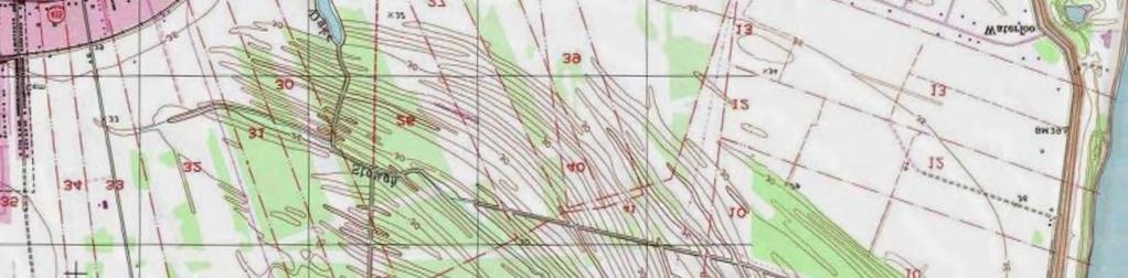
9 3.0 CCR ASH BASIN OVERVIEW Pertinent site information and history related to the installation and operation of the Fly Ash Basin and Bottom Ash Basin is presented below to provide context for the Liner Certification documentation. 3.1 Location, Topography, and Character The LaGen BC II Plant is located at Cajun II Road, New Roads, Pointe Coupee Parish, Louisiana. The BC II Plant is situated in Sections 4, 5, and 37 in Township 4 South and Range 11 East. The Fly Ash Basin and Bottom Ash Basin are located on the southwest end of the surface impoundments west of the BC II Plant and are bordered on the west by wooded property, a drainage ditch, and agricultural land; on the north by wooded property and agricultural land; and on the south by wooded property and grassy fields, as detailed on Figures 1 and 2. Both the Fly Ash Basin and Bottom Ash Basin were constructed and became operational in The CCR units were constructed above natural grade with a base of approximately 30 feet Mean Sea Level (MSL). The Fly Ash Basin was constructed with a surrounding berm with a designed crest elevation of 40-feet MSL. The Bottom Ash Basin was constructed with a surrounding berm with a designed crest elevation of 48-feet MSL. The existing site topography is depicted on Figure 3. The Fly Ash Basin has a permitted total ash storage capacity of 3,905,000 cubic yards (yd 3 ). The Bottom Ash Basin has a total permitted ash storage capacity of 2,585,000 yd Existing Regulatory Permits The Fly Ash Basin and Bottom Ash Basin have been granted and are currently operating under a Louisiana Department of Environmental Quality (LDEQ) Solid Waste Permit as industrial surface impoundments in accordance with the Louisiana Solid Waste Regulations (LAC 33:VII) under Permit Number P-0108R1 and Facility Identification Number GD The Solid Waste Permit renewal was issued by the LDEQ on February 24, 2011 and allows CCR materials generated on-site at the LaGen BC II Plant to be properly disposed of within the boundaries of the Fly Ash Basin and Bottom Ash Basin. 3.3 Fly Ash Basin and Bottom Ash Basin Operation and Conditions The Fly Ash Basin is used to collect and store fly ash generated from the burning of finely pulverized coal in a high efficiency boiler. Fly ash is collected, stored in a silo and then transported by truck to the Fly Ash Basin for disposal. Fly Ash and Bottom Ash Basin Liner Certification (FINAL).docm 3-1 October 2016
10 The Bottom Ash Basin receives bottom ash from Units 1 and 3, as well as sediment from the clarifier beds associated with the cooling towers and boilers. Bottom ash is generated concurrently with fly ash during the combustion of coal. It is formed in the boiler when particles of ash fuse together. These fused particles become too large to remain entrained in the rising flue gas and fall to the bottom of the boiler. The bottom ash from Unit 1 is collected in hoppers at the base of the boiler of Unit 1 and then transported hydraulically (sluiced) through a pipe directly to the south part of the Bottom Ash Basin. Bottom ash from Unit 3 is collected in hoppers at the base of the boiler and trucked in a hydrated state to the southwest corner of the Bottom Ash Basin for disposal. The clarifier sediments are piped to the southeast corner of the Bottom Ash Basin. The Fly Ash Basin surface water runoff is directed by an interior drainage swale to a pipe connection into the Bottom Ash Basin. The Bottom Ash Basin sluice water and surface water combined with surface water runoff from the Fly Ash Basin are directed by an interior swale to a weir located at the northeast corner of the Bottom Ash Basin. A 30-inch diameter pipe carries the combined water by gravity flow to the Rainfall Surge Pond. Water from the Rainfall Surge Pond is then pumped into the Primary Treatment Basin for further treatment. Water flows by gravity from the Primary Treatment Basin to the Secondary Treatment Basin. A pump station moves water from the Secondary Treatment Basin to the Mississippi River discharge point in accordance with the Plant s LPDES permit (Permit No. LA ). Fly Ash and Bottom Ash Basin Liner Certification (FINAL).docm 3-2 October 2016
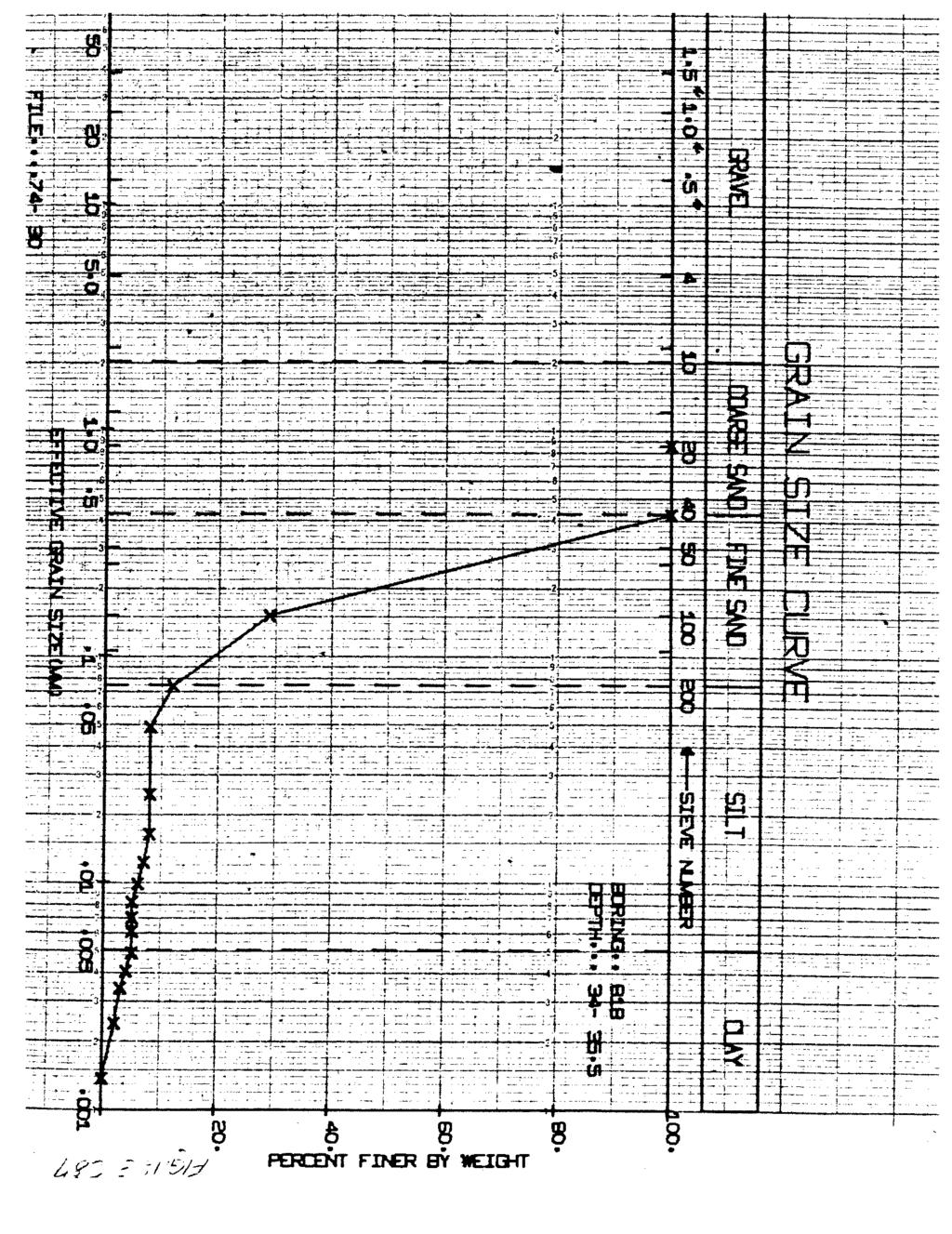
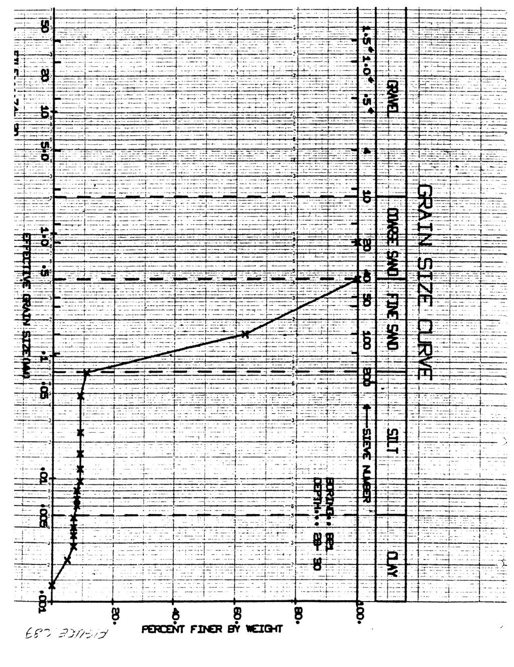
11 4.0 LINER CERTIFICATION DOCUMENTATION Supporting documentation for the liner evaluation and liner certification for the Fly Ash Basin and Bottom Ash Basin are presented below in accordance with the cited CCR Rule requirements. 4.1 Liner Evaluation At the time the Fly Ash and Bottom Ash Basins were constructed, the design and installation of the Ash Basins met the requirements of the Louisiana Solid Waste Regulations. These regulations required that the permitted impoundments be constructed with a minimum of 3 feet of soils that would provide a barrier to prevent any penetration of surface spills into groundwater aquifers underlying the area or to an underlying sand or other permeable stratum that would provide a conduit to such aquifers. To meet that requirement, the impoundments were constructed over native clayey soils with some areas being supplemented with a 1-foot thick recompacted clay to ensure the combination of native clayey soil and recompacted clay had a minimum thickness of 3 feet everywhere across the bottom of the Basins. The CCR Rule does not mention the use of native soil to meet the CCR Rule liner requirements. Accordingly, an evaluation of the site conditions and CCR Rule is necessary to determine if the subsurface conditions beneath the Ash Basins meet the intent of the CCR Rule liner certification requirements Previous Investigation Soil Boring Data Prior to construction of the Ash Basins, a subsurface soil investigation was conducted in 1977 to evaluate the soils at the Site. The 1977 investigation included the installation and sampling of approximately 223 borings drilled to depths of 10 feet below ground surface (bgs) and an additional 37 borings advanced to depths of approximately 32 to 54 feet bgs, all on a 250-foot spaced grid pattern across the footprints of the Fly Ash Basin, Bottom Ash Basin, and other non- CCR impoundments at the BC II Plant site. The investigation included laboratory testing of soil samples from selected borings for various geotechnical parameters (Atterberg Limits Determination, dry density, moisture content, grain size analysis, and permeability). All geotechnical characterization and testing was performed by Louis J. Capozzoli and Associates, Inc. using laboratory procedures that conform to appropriate ASTM standards, which are recognized and generally accepted methods. A copy of the boring logs from the 1977 investigation is presented in Appendix A and a copy of the geotechnical laboratory results is presented in Appendix B. Fly Ash and Bottom Ash Basin Liner Certification (FINAL).docm 4-1 October 2016
12 4.1.2 Geotechnical Testing and Evaluation Results A review and evaluation of the lithologic and laboratory geotechnical testing data and results from the 1977 investigation indicate that the native soil lining the Fly Ash and Bottom Ash Basins consists of clayey soils ranging in thickness from 3 to more than 10 feet over 97 percent of the site. An isopach map depicting the thickness of the clayey soils underlying the Fly Ash and Bottom Ash Basins (and other surface impoundments) is presented on Figure 4. The clayey soils consist predominately of clay and silty clay, plus some clayey silt, meeting the required coefficient of permeability (no more than cm/sec) with a maximum permeability of 6 x 10⁻⁸ cm/sec for a clayey silt. The laboratory permeability test results of less than 1 x 10⁻⁷ cm/sec are typical for high plasticity clays and clayey silts. Approximately 7 percent of the test borings indicated a clayey soil thickness of less than 3 feet. The areas of clayey soil that were less than 3 feet thick were resurfaced with additional recompacted clay during the construction of the impoundments to ensure a minimum clayey soil thickness of 3 feet below the impoundments. Cross sections from the original solid waste permit application for the Fly Ash and Bottom Ash Basins showing the thickness of the native and recompacted clay layer lining beneath the Fly Ash Basin and Bottom Ash Basin are shown on Figures 5 through 8. A plot showing the classification of the native fine-grained soil types within the uppermost 10 feet bgs, based on a determination of Atterberg Limits, is included in Appendix C. The figure in Appendix C shows the native soil samples plotting in the high plasticity lean clay (CL) and fat clay (CH) areas in a line parallel to and above the A-Line which is anticipated for soils of similar geologic origin. These high plasticity soil sample results indicate that these soils would have permeabilities similar to the laboratory tests. The figure also shows a few samples plotting in the low plasticity silt and clayey silt area, indicating low plasticity. A review of the data indicates these samples to be mostly deeper than 3 feet and dispersed aerially over the basins. These samples would have a limited effect on the overall liner protectiveness. Based on the information and evaluation provided above, the Ash Basins at the BC II Plant meet the protectiveness intent of the CCR Rule Liner Certification requirements. Fly Ash and Bottom Ash Basin Liner Certification (FINAL).docm 4-2 October 2016
13 5.0 RECORD KEEPING/NOTIFICATION REQUIREMENTS As required in (f)(2), LaGen will maintain files of all information related to the liner certification of the Fly Ash Basin and Bottom Ash Basin in a written operating record at their facility as required by the CCR Rule. The files will be retained for at least 5 years following the date of each occurrence, measurement, maintenance, corrective action, report, record, or study. The files for the liner certification will be maintained in one recordkeeping system with files separated by the name or identification number of each CCR unit. It is understood the files may be maintained on microfilm, on a computer, on computer disks, on a storage system accessible by a computer, on magnetic tape disks, or on microfiche. 5.1 Notification Requirements Per (f)(3), the CCR Rule notifications required for liner certification of the Fly Ash Basin and Bottom Ash Basin will be sent to the relevant Administrative Authority/State Director within 30 days of placing them in the facility s operating record (and on LaGen s publicly accessible Internet site). The notifications for separate CCR units undergoing liner certification at the BC II Plant will be combined for record keeping purposes and identified by the name or identification number of each CCR unit. 5.2 Publically Accessible Internet Site Requirements As required by (f)(3), LaGen will post the following information for the liner certification of the Fly Ash and Bottom Ash Basins to the CCR Web site within 30 days of placing the pertinent information in the facility s operating record. The files for separate CCR units undergoing liner certification at the BC II Plant will be maintained in one recordkeeping system with files separated by the name or identification number of each CCR unit. The files will be made available to the public for at least 5 years following the date on which the information was first posted to the CCR Web site. Fly Ash and Bottom Ash Basin Liner Certification (FINAL).docm 5-1 October 2016
14
15 7.0 REFERENCES Environmental Protection Agency; 2015; 40 CFR Parts 257 and 261 Rules and Regulations, Hazardous and Solid Waste Management System; Disposal of Coal Combustion Residuals from Electric Utilities; Volume 80, No. 74; Final Rule. Louis J. Capozzoli and Associates, Inc.; 1974; Preliminary Subsoil Investigation and Foundation Design Data, Big Cajun No. 2, Site C-2, New Roads, Louisiana; File No Louis J. Capozzoli and Associates, Inc.; 1977; Preliminary Subsurface Soil Investigation and Laboratory Testing, Ash Storage Area, CEPCO No. 2, Plant Site; New Roads, Louisiana. Louis J. Capozzoli and Associates, Inc.; 2005; Geotechnical Investigation, Bottom Ash Storage Pond Expansion, Big Cajun No. 2, Pointe Coupee Parish Plant Site, Louisiana; LJC&A File: Shaw Environmental & Infrastructure, Inc.; 2010; Type I Solid Waste Facility Permit, Renewal and Modification Application, Final Copies, Permit No. P-0108 (Volumes 1 of 2 and 2of 2), Louisiana Generating, LLC, Big Cajun II Power Plant, New Roads, Pointe Coupee Parish, Louisiana. Fly Ash and Bottom Ash Basin Liner Certification (FINAL).docm October
16 FIGURES


17 idocs Document No.; Issue Statement; Rev. 0; 22Sep2016 Property Boundary Bottom Ash Basin Treatment Ponds Rainfall Surge Pond Fly Ash Basin J:\Drafting\NRG\ \ArcView\GIS_Documents\Project_Maps\nrg_ _0015_site_location.mxd; Analyst: ben.holt; Date: 9/22/2016 1:17:25 PM 0 1,500 3,000 6,000 Feet FIGURE NUMBER 1 Copyright: 2013 National Geographic Society LOUISIANA GENERATING, LLC BIG CAJUN II POWER PLANT NEW ROADS, LOUISIANA BIG CAJUN II POWER PLANT LINER CERTIFICATION SITE LOCATION CB&I Environmental & Infrastructure, Inc Essen Lane Baton Rouge, Louisiana 70809
18 idocs Document No.; Issue Statement; Rev. 0; 22Sep PRIMARY TREATMENT POND RAINFALL SURGE POND MISSISSIPPI RIVER INDUSTRIAL WASTE CANAL COAL STORAGE FLY ASH BASIN BOTTOM ASH BASIN 12 STORAGE SILOS CONVEYOR BELT LEGEND J:\Drafting\NRG\ \ArcView\GIS_Documents\Project_Maps\nrg_ _0016_site_layout.mxd; Analyst: debbie.comeaux; Date: 9/22/2016 1:20:14 PM INTERIOR DRAINAGE SWALE 30" DIA. PIPE EXIT WEIR BUTTREFLY VALVE JUNCTION BOX DISCHARGE LIFT STATION CHEMICAL STORAGE DISCHARGE TO PRIMARY TREATMENT AERATOR LIFT STATION TO MISSISSIPPI RIVER ACCESS ROAD SECONDARY TREATMENT POND Source: Esri, DigitalGlobe, GeoEy User Community BOILER NO. 3 BOILER NO ,600 Feet BOILER NO. 1 FIGURE NUMBER 2 BARGE UNLOADING LOUISIANA GENERATING, LLC BIG CAJUN II POWER PLANT NEW ROADS, LOUISIANA BIG CAJUN II POWER PLANT LINER CERTIFICATION SITE LAYOUT CB&I Environmental & Infrastructure, Inc Essen Lane Baton Rouge, Louisiana 70809
19

20
21
22
23
24
25 APPENDIX A
26
27
28
29
30
31
32
33
34
35
36
37
38
39
40
41
42
43
44
45
46
47
48
49
50
51
52
53
54
55
56
57
58
59
60
61
62
63
64
65
66
67
68
69
70
71
72
73
74
75
76
77
78
79
80
81
82
83
84
85
86
87
88
89
90
91
92
93
94
95
96
97
98
99
100
101
102
103
104
105
106
107

108

109

110

111
112
113
114
115
116
117
118
119
120
121
122
123
124
125
126
127
128
129
130

131

132

133

134

135

136
137

138

139
140
141
142
143
144
145
146
147
148
149
150 APPENDIX B
151
152
153
154
155
156
157
158
159
160
161
162
163
164
165
166
167
168
169
170
171
172
173
174
175

176
177

178

179

180
181
182 APPENDIX C
183 Depth (ft bgs): ATTERBERG LIMITS SOIL CLASSIFICATION PLOT 0-10 Feet Below Ground Surface (302 Samples) PLASTICITY INDEX B-Line CL CH MH or OH 10 CL - ML 0 ML or OL LIQUID LIMIT