Karen Evens, Watershed Unit Northeast Regional Office, MPCA Duluth MN
|
|
|
- Donna McDowell
- 5 years ago
- Views:
Transcription


1 Karen Evens, Watershed Unit Northeast Regional Office, MPCA Duluth MN
2 It is a process It is a formula It is a final study or report submitted for state review and approvals and to EPA for approval. Systematic / holistic approach. It must include a public participation element
 + WLA(s) + Margin of Safety + Reserve Capacity = Total Maximum")


3 A TMDL Study must complete this pollution load allocation formula: LA(s) + WLA(s) + Margin of Safety + Reserve Capacity = Total Maximum Daily Load Where: LA = Load allocations from nonpoint sources WLA = Waste load allocations from point sources Margin of Safety = to account for potential scientific error Reserve capacity = set aside for future development Reasonable assurance, implementation and monitoring addressed
4 Collaborative Learning TMDL, watershed science, behavior changes Manage controversy, legal challenges, critics Creates a transparent process improves accountability, trust Inspiring, creative, strategizing Broader outreach and advocacy Required

5 Water quality problem identification stage Water quality goalsetting Workplans Point/nonpoint allocation determination Open houses, public meetings An organization DRAFT TMDL Study public comment period TMDL Implementation Plan development Advocacy and implementation Monitoring
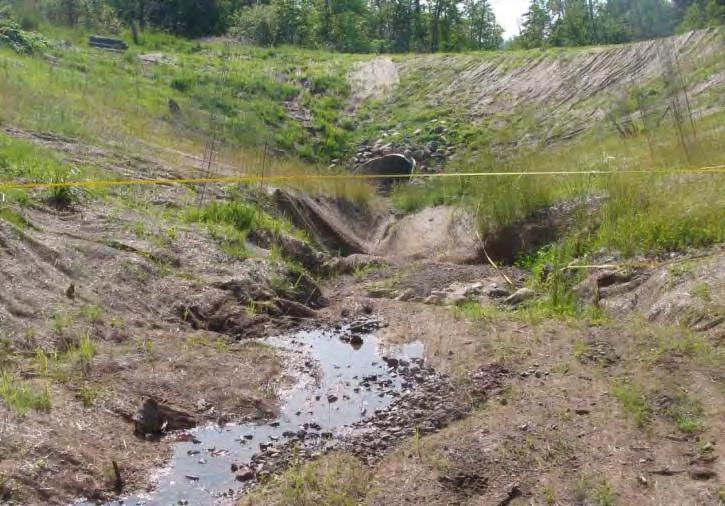
6 Poplar River TMDL data organized to satisfy the formula and study requirements Estimated Sediment Sources Contributing to Turbidity in the Lower Poplar River Watershed Median Sediment Load Minimum Sediment Load Maximum Sediment Load Source Ton/year % Ton/year % Ton/year % Channel Incision 53 3% 18 2% 88 3% Megaslump % % % Other Landslides % % % Golf % 7.6 1% % Developed % % % Ski Runs, Trails, and Roads % % % Forest % % % Gullies/ Ravines % 50 5% % Total Loading Capacity and Required Reductions for Each Flow Zone Based on the Load Duration Curve (with MOS) Approach High Flows Moist Conditions Mid-Range Flows Dry Conditions Low Flows Flow Interval (CFS) > < 18 Flow Interval (%) 0 10% 10 40% 40 60% 60 90% % Capacity (lbs/day) 25,297 7,532 3,281 1, Capacity (Tons/day) MOS (lbs/day) 8,408 3, MOS (%) 33% 42% 19% 37% 98% Allocation (lbs/day) 1 16,889 4,397 2,672 1, Current Load (lbs/day) 2 240,623 23,853 28,607 1, Current Load (Tons/day)


7 Erosion potential ranked : Ditches Road cuts Gully formation Culverts Distance to river Slope Road length


8 Soil Samples collected Major concerns Gully formation Less infiltration Proximity to river Graded slopes Ski slopes ranked according to sediment delivery potential score based on: Gully formation Distance to river Area of the slope Amount of vegetation Berming Grading

9 Sediment delivery potential was scored only for the lower reaches of the ski slopes. Parameters weighted with a maximum score of 55. Ski Run Mountain Total Score Sediment Delivery Potential Lower Caribou Moose 11 low Lower Cascade Moose 11 low Lower Meadow Moose 16 low Bull Access Moose 19 low Lower Bull Run Moose 19 low Moose Drop Moose 19 low Sugar Maple Mystery 45 very high Log Chute Mystery 39 high White Birch Mystery 42 very high Grouse Gully Mystery 42 very high Jack Alder Mystery 40 very high Brule Eagle 27 medium River Run Eagle 29 medium Lower Bridge Eagle 32 high Timber Jack Eagle 29 medium Karen's Corner Ullr 32 high Ullr Ullr 27 medium Flapjack Ullr 27 medium 4-Corners Ullr 32 high
 100 80 60 40 20 40 in/h 18 in/h 2 in/h 0 forest ungraded ski slope graded ski")
10 Land use dependent infiltration capacity data obtained from 33 paired field infiltration tests 120 Saturated hydraulic conductivity (inch/hour) in/h 18 in/h 2 in/h 0 forest ungraded ski slope graded ski slope


11


12 Field reviewed Located using GPS Cross sectional and profile surveys performed High sediment load, small surface area Soil Samples collected Soil shear strength Bulk density BEHI score analysis will be performed Evidence of high sediment load in forested ravine


13
14 Implementation Plan - Best Management Practices Project and Budget Project Estimated Cost 1.Ullr Tightline * $270, Caribou Highlands Stormwater Corridor * $253, Lower Eagle Mountain Road * $50, Mystery Mountain Road $60, Lower Mystery Mountain Flow Path * $15, Moose Mountain Summit Road $96, Eagle North Face Road $49, Ullr Road $57, Timberwolf Road $33, Lutsen Resort Trail Rehabilitation $10, Time Period Objective Lead Cooperating Partners Top 10 BMPs Area landowners SWCD, BWSR, completed, MPCA, DNR 2010 and ongoing Completed BMPs assessed annually, maintained per schedule Objective measurements 10 installations completed, 400 tons sediment reduced Landowners SWCD Annual checklist completed. Repairs completed and ongoing Erosion/stormwat er ordinance enforced Cook County Zoning MPCA 100 % Permits issued meet code. 100% Inspection reports complete and in compliance 2010/11 5 yr review intervals Lutsen AUAR mitigation plan elements enforced Cook County Zoning AUAR committee, landowners # of LID practices for new developments 2013 and ongoing ongoing Monitoring data collected and evaluated. Biological data collected in 2013/14 flow and chemistry ongoing Landowner education and engagement MPCA, DNR PRMB landowner organization SWCD, landowners SWCD, MPCA, DNR Stream chemistry, flow, biology, geomorphology collected and assessed # of projects, media info/planning and outreach efforts


15 Meeting standards & Clean Water Act Supporting aquatic life & beneficial uses Protecting our northern quality of life Thank you for your attention and interest