From Planning to Action: Mainstreaming Adaptation Strategies in Nags Head, NC
|
|
|
- Coral Harris
- 5 years ago
- Views:
Transcription


1 From Planning to Action: Mainstreaming Adaptation Strategies in Nags Head, NC October 30, 2018 NC Sea Grant & Town of Nags Head
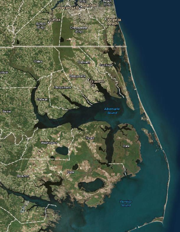

2 Nags Head
 40,000")


3 Setting Population 2,954 (year round) 40,000 (seasonal) 11 miles of shoreline 85% of Town on septic Key Dates- Incorporated 1961 Land Development Plan 1964 Zoning, Subdivision, Flood Maps 1970 s

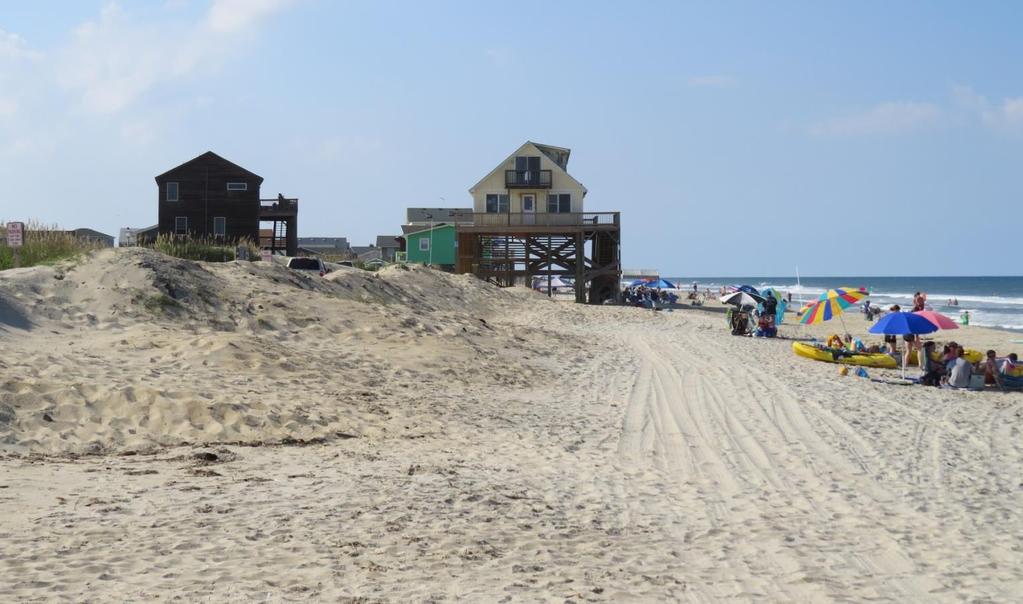
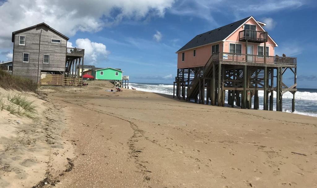
4 S. Nags Head- 1980

5

6 Hurricane Matthew ~ 2016
7 Multiple Decision-Makers Dare County: Drinking water Environmental Health Emergency management State of North Carolina: Roads, drainage in South Nags Head, Hwy 64 Jockey s Ridge State Park CAMA/Floodplain Management Inlet management Federal Government: Nat l Park Service marshes in South Nags Head Inlet management Other: Nature Conservancy- Nags Head Woods


8

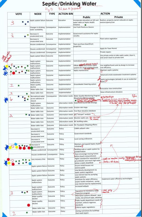
9 1. FOCUS Comprehensive Plan All policy issues- land use, environmental, transportation, economic development, municipal services Establishes vision, strategic, action oriented, policy document rooted in community & stakeholder input. 2. VCAPS Project (Vulnerability, Consequences, Adaptation, Planning, Scenarios) Sea level rise, other coastal hazards, & adaptation strategies Community & stakeholder driven process, identified vulnerabilities, explore adaptation options, & assess community knowledge
10 Key Community Members & Groups Local Business Committee Planning Board Dare County Representatives Building Community Oceanfront property owners Recreation Historic Nags Head Accommodations Town Staff Board of Commissioners Churches and Non-profits Commercial Overlay District/Event Site Area Individuals with Institutional Knowledge Outer Banks Visitors Bureau FOCUS: 70+ individual interviews VCAPS: 19 individual interviews
11 Committees o FOCUS Advisory Committee o Sea Level Rise Committee Represent a broad range of interests, backgrounds, and points of view Representation: Board of Commissioners Member Planning Board Member Full Time residents with geographic representation Engineer/Architect Development/Building Community Business/Service Community Finance Real Estate/Insurance Retail Food Service Arts/Culture Environment Public Safety Recreation Tourism Non-Profit
12 NC Sea Grant Partnership Vulnerability, Consequences, and Adaptation Scenario Process (VCAPS) Dialogue about hazards, e.g., sea level rise, flooding, coastal storms. How do these hazards impact Nags Head? What factors that make consequences better or worse for the Town? What actions (public & private) can be undertaken? VCAPS captures and documents current and potential actions~ both desired and not desired.


13 Probing questions, integrative discussion What impacts do floods have in your community? Why do you care about the impacts? What is the result? What makes these impacts better, worse, larger, smaller? What can you do to prevent or mitigate this?
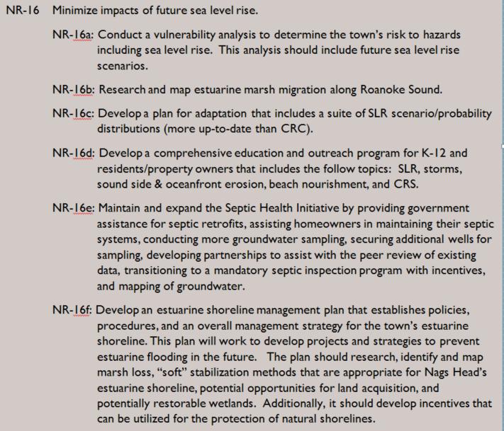
 Utilize visualization techniques AKA influence diagrams or causal pathway")
14 VCAPS Helps people think about flood hazards Structure discussions using conceptual frameworks Analytic-deliberative process Causal structure of hazards Vulnerability (sensitivity, adaptive capacity, resilience) Utilize visualization techniques AKA influence diagrams or causal pathway diagrams
")
15 VCAPS Efficiently Reasonable (and flexible) demands on time and resources Produces useable knowledge. Focus on what is relevant to participants and decisions Co-construction of scenarios Allow exploration of (local) complexities and uncertainties


16 VCAPS supports initial phases of resilience planning and implementation through group discussion and learning supported by real-time diagramming.

17 VCAPS Diagrams: Building Blocks
18
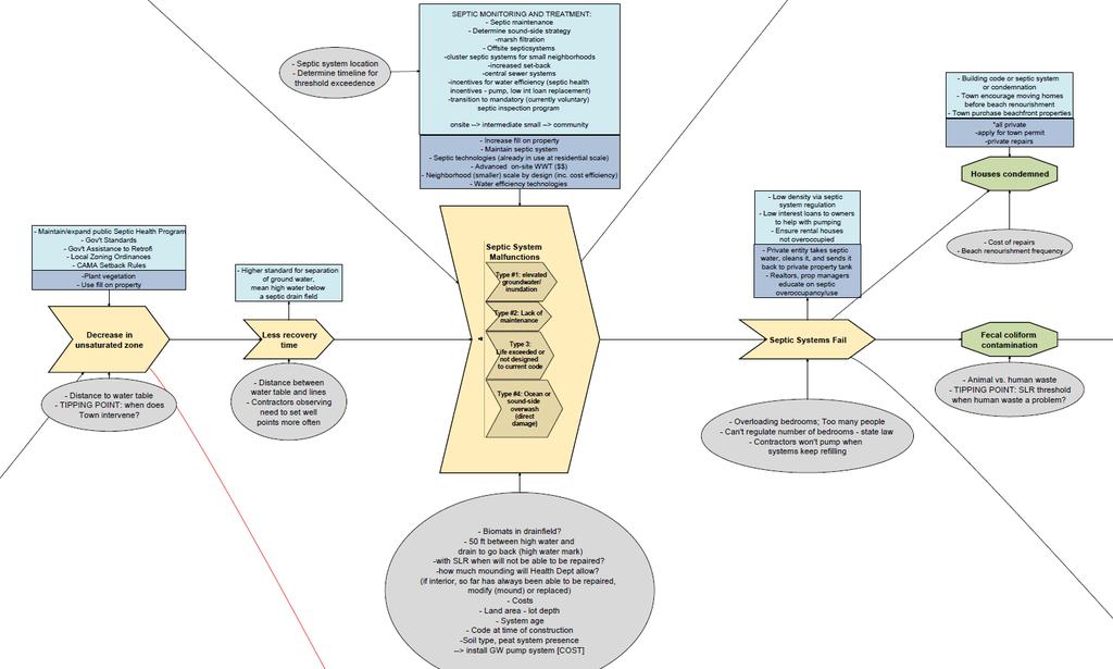
19


20 Outcomes Actions fit into major categories: 1. Ocean shoreline management 2. Estuarine shoreline management 3. Stormwater management 4. Water (ground/surface) management
21
22 Actions 1. Maintain and expand the Septic Health Initiative. 2. Develop a comprehensive education and outreach plan on sea level rise and other hazards. 3. Develop an estuarine shoreline management plan 4. Develop a plan for sea level rise that includes a suite of sea level rise scenarios/probability distributions. 5. Develop a long term shoreline management plan. 6. Develop a long range plan for stormwater. 7. Promote and install living shorelines.

23 Policy

24 Policy

25
26 Challenges Many county, state, federal regulations Maintaining water quality Maintaining community character and quality of life Identifying tipping points Septic system function vs water quality Erosion and real estate market
27 Challenges Range of scenarios and downscaled data: how to make decisions based on what s available? How will the Town fund adaptation? Maintenance Cross-scale collaboration to apply for funding What about issues not within the Town s jurisdiction?
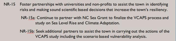
28 Keys to Success 1. Community engagement and support of elected officials is paramount. 2. Build on existing processes & plans. 3. Add the extra layer/lens of sea level rise. 4. Identify actions not only for the community for but individual citizens. 5. Network, let others know what you are doing, and how your community needs assistance. 6. Increase focus on estuarine shorelines and relationship between groundwater, stormwater, septic health (water quality), and flooding.

29 A resilient Nags Head means Withstand, respond to, and recover rapidly from disruptions without long-term damage to the economy or environment; Requires less government funding to recover, rebuild and redevelop its communities; and Sustains the way that natural systems provide ecosystem services that directly or indirectly support human survival and quality of life.
30 Jessica Whitehead, Ph.D. Coastal Communities Hazards Adaptation Specialist NC Sea Grant Holly B. White, AICP, CFM Principal Planner Town of Nags Head