Meacham Creek Restoration Project
|
|
|
- Beverly Ross
- 5 years ago
- Views:
Transcription
1 Meacham Creek Restoration Project Meacham Creek Restoration Project Umatilla National Forest Walla Walla Ranger District Michael Rassbach, District Ranger Public Scoping Document Proposal Summary The Walla Walla Ranger District and Confederated Tribes of the Umatilla Indian Reservation (CTUIR) are partners in a joint effort to conduct stream restoration activities on a segment of Meacham Creek. The proposal will re-align the channel to an older more natural configuration, re-create meanders, allow the river better access to its floodplain, increase habitat complexity and provide for protection of adjacent railroad infrastructure. Date: 09/30/2010
2 Page 2
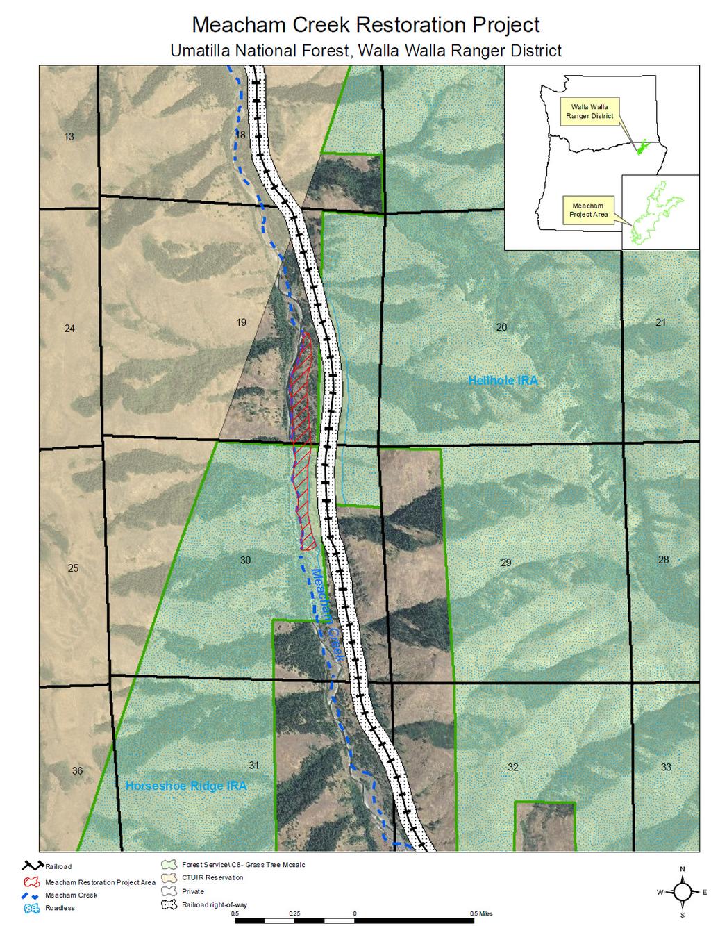
3 USDA Forest Service Background Early History: Beginning in the late 1800 s, the lower reaches of Meacham Creek were channelized, cleared, and partially constricted by levees for railroad construction. These activities simplified and degraded aquatic habitat. Meacham Creek and its tributaries host ESA Threatened mid-columbia steelhead and a few ESA Threatened Columbia River bull trout, and is Magnusson-Stevens essential fish habitat for Chinook salmon. The hydrologic processes of the Meacham Creek watershed are largely undisturbed, with a flow regime and sediment load that are largely unimpaired. Location: The planning area includes portions T2N, R36E, Section 30 (on NFS lands). The CTUIR would also conduct coordinated work on T2N R36E, section 19 (adjacent, non-nfs lands) as part of the same project. Meacham Creek stream channel and valley bottom from about six miles upstream of the mouth of Meacham Creek and continuing onto National Forest land for about 0.6 miles upstream. Total length of project work, including both National Forest land and non-national Forest would be about one and three-tenths miles (river miles 6 to 7.3). Forest Plan Management Area: The proposed project activities on NFS lands occur entirely within Umatilla NF Land and Resource Management Plan (Forest Plan) Management Area C8 (Grass-Tree Mosaic). Existing Condition: Currently Meacham Creek is channelized by several spur dikes and a 2,800-foot levee, all occur within the floodplain of Meacham Creek. The floodplain exist between the current channel, which has been forced up against the canyon wall, and the railroad right-of-way. All project activities will occur within this floodplain. Page 3
4 Purpose and Need The potential exists to restore lower Meacham Creek to a more complex, ecologically productive condition if artificial constraints are removed. This would support recovery of the Threatened mid-columbia steelhead trout and Columbia River bull trout and support fulfillment of obligations of the Forest Service under The Endangered Species Act of 1973 Section 2(c). The following needs have been identified for this proposed action: Restore stream channel to near historic configuration Restore floodplain connectivity Improve channel morphology and in-stream processes Improve hydrologic connectivity and function Enhance in-stream habitat and diversity for both ESA listed and non-listed fish species Increase riparian shade Protect the existing Railroad Right-of Way (ROW) and associated railroad infrastructure Proposed Action The channel realignment effort would increase the stream length from 5,470 feet (existing channel) to 5,780-feet (reconfigured channel). This realignment would require the removal or modification of six large spur dikes that occur within the floodplain as well as remove a 2,800-foot levee that occurs along the existing channel. The project will result in the removal of several trees within the floodplain some of which will be greater than 21 inches in diameter at breast height (dbh). Cut vegetation will be utilized on site as large woody debris for fisheries habitat and will have the root wads attached when possible. None of the cut vegetation will removed from the project site as part of this project, regardless of its size. A new protection levee will be constructed in order to protect the railroad and railroad access road. The protection levee will be installed at locations in the floodplain adjacent to the 100-foot railroad right-of-way to provide flood protection equivalent to a 100-year flood event. Large logs and rock structures will be placed throughout the floodplain and near the protection levee. Page 4
5 USDA Forest Service Proposed Action Cont d The project activities will result in approximately 30 to 40 acres of disturbed areas in the floodplain and along the channel. These areas will be revegetated with native weed-free plants. The areas may also be reseeded with a native seed, weed-free mist throughout the project site. Fish salvage will be done by the Oregon Department of Fish and Wildlife (ODFW) or other qualified fish biologists by blocking the upstream and downstream extents of the existing channel and capturing and releasing fish from the isolated areas using trapping, seining, electrofishing, or other established methods as are prudent to minimize risk of injury. Block nets will be installed approximately 60-feet upstream and 40-feet downstream from the in-water work area. These nets will remain in place until the existing channel is blocked with material and the reconfigured channel is watered to prevent fish from entering the project site. As the existing channel is dewatered, any remaining fish will be removed from remaining pools with dip nets. Captured fish will be placed into aerated transport containers filled with water from the stream and maintained at the same temperature as the existing stream temperature. Fish will be transported to an upstream location and released. The equipment for fish removal will be available on site and the timing of the fish removal will be coordinated with the con- Page 5

6 Project Implementation Schedule The project will be completed in two phases to ensure integrity to the stream channel and reduce impacts on water quality and aquatic organisms. Throughout both phases of the project, equipment will be refueled and maintained in a staging area at an approved site away from the active channel and outside of the Riparian Habitat Conservation Area (RHCA). Phase 1- work would consist of excavating the new channel, installing habitat improvement features, and removing or modifying the six large spur dikes. Material from the removal or modification of the six large spur dikes will be used to construct the railroad protection levee. Any additional material needed for the protection levee will come from a rock quarry near the project site. Phase 1 work is anticipated to occur yearround, as the weather permits. Phase 2- work will consist of the removal of the 2,800-foot levee along the existing channel and connecting the existing channel with the new reconfigured channel and filling in the old channel with base material available from removing the 2,800-foot levee. To minimize impacts to fish in Meacham Creek, phase 2 is anticipated to occur between July 1 and August 15. Page 6
7 USDA Forest Service Reasons for Categorical Exclusion: Activities that fall within one or more categories of action set forth at 36 CFR 220 do not require further analysis in either an environmental impact statement (EIS) or an environmental assessment (EA) because there are no extraordinary circumstances related to the proposed action. The environmental effects analysis is ongoing toward the determination of whether extraordinary circumstances exist. At this time, it is believed that this action does not contain extraordinary circumstances that would preclude the use of categories 36 CFR 220 (e)(6) Timber stand and/or wildlife habitat improvement activities that do not include the use of herbicides or do not require more than 1 mile of low standard road construction and 36 CFR 220 (e)(7) Modification or maintenance of stream or lake aquatic habitat improvement structures using native mate- Resource Conditions under consideration in the determination of whether Extraordinary Circumstances exist: Federally listed threatened or endangered species or designated critical habitat, species proposed for federal listing, or Forest Service sensitive species: Although potential effects to Threatened and Endangered Species (TES) aquatic and terrestrial wildlife species is possible, early analysis indicates that any potentially adverse affects of this proposal will be short in duration and will be offset by the long-term benefits associated with the establishment of the more robust and properly functioning aquatic habitat that will result. Floodplains, wetlands, or municipal watersheds. The project would occur within the floodplain of Meacham Creek. Consultation with the US Army Corps of Engineers is ongoing. Floodplain restoration would reduce erosion and increase floodplain function to near historic levels. Based on preliminary analysis this project is not expected to result in an increased risk of flood effects to existing infrastructure. There are no jurisdictional wetlands in the project area. There are no Municipal watersheds in the project area. The area is mapped as source water for the City of Pendleton. Pendleton's surface water supply is treated with membrane filtration and the intake is more than 20 miles downstream of the project. No detrimental affect to the water supply of the City would be expected. Page 7
8 Congressionally designated areas, such as wilderness, wilderness study areas, or national recreation areas. The project area does not contain any congressionally designated wilderness, wilderness study areas, or national recreation areas (Final EIS, Umatilla National Forest Land and Resource Management Plan, Appendix C). Inventoried Roadless Areas or Potential Wilderness On NFS managed land, the proposed actions would occur within a small portion of the Horseshoe Ridge Inventoried Roadless Area (IRA). Although the proposed action would result in the cutting of trees (but not the removal of cut trees) within this small portion of the Horseshoe Ridge IRA, the proposal is consistent with relevant Research natural areas The project area does not occur in a research natural areas (Final EIS, Umatilla National Forest Land and Resource Management Plan, p. 4-31). American Indians and Alaska Native religious or cultural sites The project area is within American Indian's ceded lands. No information on locations or concerns of religious sites has been made at this time. Consultation with local Tribes is ongoing. Archeological sites, or historic properties or areas An appropriate inventory has been conducted for this project. All known sites will be avoided. Should any additional sites be identified during ground disturbance activities, Forest archeology staff would immediately be notified. For More Information: Details of this project, including maps, may be viewed at Walla Walla Ranger District office in Walla Walla, Washington. For further details contact Dave Crabtree, Project Team Leader or Kimpton Cooper, District Environmental Coordinator, at the Walla Walla District office, 1415 W. Rose, Walla Walla, WA 99362, telephone (509) Page 8