Restoration of bog hydrology in Latvia. Dr biol.mara Pakalne, Dr. Geol. Aija Delina University of Latvia, Latvia
|
|
|
- Edith Holmes
- 5 years ago
- Views:
Transcription


1 Restoration of bog hydrology in Latvia Dr biol.mara Pakalne, Dr. Geol. Aija Delina University of Latvia, Latvia

2 Aim of presentation Characterise mire habitat restoration in the LIFE projects Reveal Reveal problems in raised bog conservation

3 Mires cover 4,9% of the total land area


4 Raised bogs

5 Human impact About half of Latvian mires have been influenced by various human activities, like drainage, peat extraction and fire Therefore, activities re-instating the mire hydrology are carried out Habitat and site hydrology monitoring was carried out before management actions.
 Decrease of the total area of the mires Changes in mire water")
6 Drainage consequences Change of the mire hydrological regime Degradation of mire vegetation Loss of the plant communities and species diversity Loss of raised bog structure (hummocks, hollows, pools) Decrease of the total area of the mires Changes in mire water quality
7 EC LIFE projects for raised bog Teici Mire ( ) 2003) Kemeri Mire ( ) 2008) management Lubana Wetland complex ( ) 2007) Implementation of Mire Habitat Management Plan in Latvia (Cena Mire, Stikli Mires and Klani Mire) ( ) 2008) Restoration of Raised bog habitats in the Especially Protected Nature Areas of Latvia (Aizkraukle Mire and forests, Aklais Mire, Rozu Mire and Melnais Lake Mire) ( ) 2013)


8 Teici Mire Ramsar site


9 Lubana LIFE project


10 Kemeri Mire LIFE project Sphagnum cuspidatum

11 Restoration of raised bog habitats in Kemeri Mire

12 EC LIFE-Nature project LIFE04NAT/LV/ Project title: Implemenation of Mire Habitat Management Plan for Latvia Duration:


13 Habitat diversity in Stikli Mires
14 Building of dams in Vasenieki Mire in May, 2007


15 2013 Vasenieki Mire
16 Fluctuation of groundwater level in Vasenieki Mire The fluctuations of groundwater level in Vasenieki Mire 20 0 Drained area (between the ditches 100 m) Drained area of bog pools (between the ditches 20 m) Drained area (between the ditches 20 m) -100 The beginning Date of dam building Groundwater depth, cm


17 Vasenieki Mire 2012


18 Estonian collegues in Vasenieki Mire


19 Invasion of Sphagnum cuspidatum in the drainage ditches

20 EC LIFE+ project LIFE08 NAT/LV/ Restoration of Raised bog habitats in the Especially Protected Nature Areas of Latvia Project duration : Project sites : Rozu Mire, Aizkraukle Mire and forests, Aklais Mire and Melnais Lake Mire


21 Project sites


22 Field studies for the elaboration of Management Plans

23 Monitoring and management actions Raising of water level by building dams on the drainage ditches to stop the degradation of raised bog habitats Habitat and site hydrology monitoring before and after management actions.


24 Aizkraukle Mire and Forests 1532 ha

25 The natural runoff is directed to W, NW and SW from the bog, to Brasla and Maizite Streams and their tributaries. Aizkraukle Mire

26 Aklais Mire 2003 ha


27 Surface runoff to the lakes and streams in the mire, to W, NE, SW. Semi-natural hydrological regime. Large lake Znotinu in the central part of the mire, and number of smaller lakes is located on the NW part of the mire. Aklais Mire


28 Melnais Lake Mire 317 ha


29 Melnais Lake Mire

30 Previous peat extraction fields

31 Melnais Lake Mire The surface runoff from the mire is directed to two main directions: to the north and northwest in the NW part of the site, to the surrounding drainage ditches in the south and southeast in the central and SE part of the site. Peat extraction activities close to the site in ties, and in the NW part of the site in 1980-ties, before the protected area is established there. First ditches dug in 1930-ties Main drainage ditches (width 3-5 m, depth 2-3 m), smaller drainage ditches, peat field ditches.


32 Development of fen vegetation Carex vesicaria Eriophorum angustifolium


33 Rozu Mire 991 ha


34 The mire is surrounded by esker type hills limiting surface runoff in these directions. There is elongated hill peninsula reaching from the SE and dividing the mire in two parts. The main direction of surface runoff is to NE, where the land surface is the lowest, and to the SW as well due to the number of ditches that are dug there, thus draining the SW corner of the mire. Mainly natural hydrological regime, most of the ditches dug in ties, just few are before that time. Rozu Mire

35 Measures for restoration of hydrological regime There are 156 dams constructed in the bogs: 59 dams in Rozu Mire, 54 dams in Melnais Lake Mire, 29 dams in Aizkraukle Mire and 14 dams in Aklais Mire.

36 Management actions in Melnais Lake Mire

37 Building of dams in Melnais Lake Mire in winter


38 Building of dams on drainage ditches 38


39 Peat dams in Melnais Lake Mire in spring 2012

40 Melnais Lake Mire


41 Rozu Mire


42 Rozu Mire Before 2010 After 2013


43 Hydrology and habitat monitoring

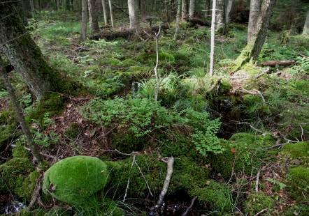
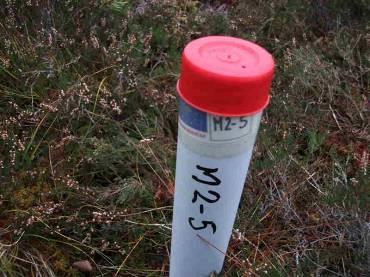
44 Hydrological monitoring Groundwater monitoring wells are located in several profiles, so that the GW table changes in the natural and disturbed parts of the bogs could be obsreved. Location of the wells: Wells are located in the most representative parts of the bogs near the planned dam locations; Wells are located in profiles, perpendicular to the ditches, where dams will be / are constructed; Several profiles are installed in the bogs, where ditches differ (dimensions, regime); Wells in each profile are located so that closer to the ditch the distance between wells is smaller, and it increases further away from the ditch: 1 m, 5 m, 10 m, 25 m, 50 m, 100 m, 250 m, 500 m. Length of the profile is m depending on the particular site. There are 9 profiles with 63 wells in total.
 determined for each well, based on that GW table")

45 Groundwater table observations Manual measurements twice per month Elevation (in m amsl) determined for each well, based on that GW table (in m amsl) calculated. Data collected and analysed based on ditch type, dam construction period and meteorological data (information from LEGMC)

 ditches, partially filled with water (Ak1, M2, A3, ~M1) 2.")
, shallow (0.2-0.5 m) ditches (A2) 4.")
46 Effects of the restoration measures GW table in the vicinity of ditch depends on type of ditch Several types of ditches are recognised in the project sites: 1. deep (3-5 m) ditches, partially filled with water (Ak1, M2, A3, ~M1) 2. deep (~3 m), wide (3-5 m) ditches, completely filled with water (A1, R) 3. small (width m), shallow ( m) ditches (A2) 4. wide (2-3 m) ditches, partially or completely overgrown with Sphagnum species and other plants (Ak2)
 After the dams construction: Sharp rise of GWT for ~0.")
47 Deep ditches, partially filled with water Sharper seasonal GWT fluctuations Range of GWT fluctuations up to m in the wells near the ditch (5-10 m) After the dams construction: Sharp rise of GWT for ~0.3 m near the ditch, slighter rise in the m distance Stabilisation of GWT (range m)

48 Deep, wide ditches, completely filled with water Seasonal fluctuations of GWT not so sharp and steep Range of GWT fluctuations m After the dams construction: Sharp rise of GWT for ~0.3 m just next to the ditch (1 m floded), slighter rise in the rest of the wells Stabilisation of GWT (range m)
, slighter rise in the rest of the wells Stabilization of GWT (range 0.15-0.")
49 Small, shallow ditches Fast respose to precipitation changes in all wells, slighter in the furthest ones Range of GWT fluctuations m After the dams construction: Sharp rise of GWT for m closer to the ditch (1-25 m), slighter rise in the rest of the wells Stabilization of GWT (range m), but still some sharp changes

50 Wide ditches, partially or completely overgrown with Sphagnum species and other plants Slow response on precipitation events Similar response in all the wells, slighly less range for the furthest ones Range of GWT fluctuations about 0.25 m in all wells After the dams construction: Slow and slight rise of GWT Stabilisation of GWT (range m)
51 Conclusions The restoration measures (dam construction on ditches) have improved the hydrological conditions in the mires, bringing them closer to the semi-natural state. The dams has caused the rise and stabilistation of groundwater table, providing more uniform moisture regime in the mire. Profiles near different ditches showed that restoration measures have the same significance both near the large ditches and small ones, either partially or completely filled with water. The less effect is obtained on overgrown ditches, where necessity of restoration measures should be studied in details in future. The direct impact of ditches is m, but there is indirect impact, bound to the surface and subsurface structure of the mire, presence of pools, their interconnectivity, that could be observed also in distance of m. This should be studied in future.


52 Raised bog vegetation monitoring Aim to follow the changes after raising of the water level Releves in intact and degraded raised bog areas
53 Results: Eastern part of Melnais Lake Mire 120 Calluna vulgaris cover, % Calluna_%_2011 Calluna_%_ M m M2-2-8m M m M m M m M m Plot number and distance from ditch, m Change of the coverage of Calluna vulgaris


54 Results: Eastern part of Melnais Lake Mire ,5 m from the ditch 2012

55 Results: Eastern part of Melnais Lake Mire Calluna ir dying out
56 Results: central part of Melnais Lake Mire Sphagnum cover, % Sphagnum_%_2011 Sphagnum_%_ M22-2m M23-8m M24-14m M25-20 m M26-26 m Plot number and distance from ditch, m Change of Sphagnum cover


57 Results: Eastern part of Melnais Lake Mire Change of the proportions in Sphagnum coverage Sphagnum cuspidatum Sphagnum magellanicum The coverage of species of more wet areas has increased Sphagnum fallax

58 Results: Central part of Melnais Lake Mire 7 Eriophorum vaginatum cover, % Eri_vag_%_2011 Eri_vag_%_ M22-2m M23-8m M24-14m M25-20m M26-26m Plot number and distance from ditch,m Change of coverage of Eriohorum vaginatum


59 Results: Central part of Melnais Lake Mire 2011 In the ditches the increase of Sphagnum species is observed, as well increases the coverage of Eriophorum vaginatum 2013

60 Conclusions The habitat monitoring results show a great difference in the coverage and species number of vascular plants and bryophytes in the intact and drained areas. The hydrological studies reveal that after the management actions was carried out, fast changes have taken place in the site hydrological regime. In Vasenieki Mire the raise the water level has raised in medium for 32.8 cm but there are places where it has raised for 52.1 cm.


61 Thanks for attention!