ARANSAS COUNTY STORMWATER MANAGEMENT PLAN
|
|
|
- Flora Wilcox
- 5 years ago
- Views:
Transcription
1 ARANSAS COUNTY STORMWATER MANAGEMENT PLAN Linda D. Pechacek, P.E. and David Reid, P.E. July 6, 2011 EPA Region 6/TCEQ MS4 Conference
2 PROJECT TEAM ARANSAS COUNTY CONSULTANTS NAISMITH ENGINEERING, INC. LIPPKE, CARTWRIGHT & ROBERTS CONSULTING ENGINEERS LDP CONSULTANTS, INC. URS CORPORATION GRIFFITH & BRUNDRETT SURVEYING & ENGINEERING STORMWATER ADVISORY COMMITTEE (SWAC) TECHNICAL ADVISORY COMMITTEE
3 PROJECT TEAM STORMWATER ADVISORY COMMITTEE (SWAC) Citizen, Chair Citizen, City of Aransas Pass Mayor, Town of Fulton Citizen (At-Large) Commissioner, AC Navigation District Mayor, City of Rockport Commissioner, Aransas County TECHNICAL COMMITTEE Citizens, representing - Master Gardeners - Master Naturalists - Aransas First Land Trust
4 ARANSAS COUNTY STORMWATER MANAGEMENT PLAN BACKGROUND Importance of Stormwater Management in Aransas County Where We Started - Three Legged Stool Natural Assets in Aransas County Quality of Life Assets at Risk

5 IMPORTANCE OF STORMWATER MANAGEMENT Aransas County 2008 Proposition #1 Passed 70% - 30% Support based on concerns about water quality, habitat conservation, drainage and flood control All entities agreed to a need for a multijurisdictional, uniform approach to Stormwater Management Purpose Statement Aransas County is an important coastal area residents desire to maintain the character of their communities quality of life protection of the environment preservation of Aransas County's unique aquatic ecosystem Integrated Approach Three Legged Stool Drainage / Flood Protection Natural Resource Protection Ecological/Habitat Integrity Stormwater Quality
6 WHERE WE STARTED Public Policy Objectives Be consistent with Aransas County Stormwater Management Policy Protect lives and property with proper stormwater management Protect public infrastructure from damage and flooding Reduce runoff of silt, pollutants and nutrients into bays with BMPs both during construction and long term using natural and man-made features to reduce peak runoff Minimize long term maintenance costs Recognize that future growth is both expected and encouraged Recognize citizen desire to maintain, preserve, and enhance the natural environment, which is a primary economic driver for the County Recognize that different parts of the County face more immediate threats from flooding and development and that different parts of the County have different physical and drainage characteristics, thus the plan may be developed and implemented in phases.


7 ARANSAS COUNTY NATURAL ASSETS AC Nav. Dist. The Bays, Estuaries, Harbors and Marinas Live Oak Woodlands Birding and EcoTourism Fishing and Hunting


8 QUALITY OF LIFE These natural assets are the reason why most of us live, play and work in AC Nav. Dist. this beautiful coastal environment, they are also the reason why people support the #1 industry in Aransas County TOURISM! Tourist come here to enjoy these natural resources and spend money in our community.


9 ASSETS AT RISK Our growth puts these assets and existing infrastructure at risk AC Nav. Dist. and with the increase of urban activity the need for proper stormwater management is imperative.
10 ARANSAS COUNTY STORMWATER MANAGEMENT PLAN STEPS TOWARD PROPER STORMWATER MANAGEMENT Data Gathering / Interim Documents Tule Creek Watershed Project Natural Resource Protection Water Quality Drainage and Flood Protection

11 DATA GATHERING / INITIAL DOCUMENTS SWAC monthly meetings for project updates, document reviews, policy guidance, etc. DATA GATHERING Commissioners and Judge, County Staff Open Houses, public workshops, etc. SWAC / Tech Committee Agencies / Public Entities TAMUCC, TxGLO, TCEQ, TPWD, USFWS, USACE, etc, Aerials / LiDAR / GIS-Digital information On-the-ground surveys (very extensive) INITIAL DOCUMENTS Interim Development and Construction Guidelines Initial Water Quality Design Criteria BMP designs LID Credits Open Houses SWAC / Technical Committee


12 NATURAL RESOURCES Indentified as a major component of the Three Legged Stool Concept throughout the County s policy and guiding principles Most visible component of the SWMP Underlying value in overall stormwater management with reduction of runoff, natural drainage corridors, depressions, wetlands, etc.


13 NATURAL RESOURCES Aransas County habitats Live Oak Woodlands upland portions of the Live Oak and Lamar peninsulas Estuarine Wetlands Riparian wetlands Blue Corridors Bays Submerged aquatic vegetation, oyster reefs, etc. Red Bobcat Photo by H. Dickson Hoese EcoTourism is a major economic force Fishing / Hunting Birding Whooping Cranes Natural Resources Plan Developed Regulatory Requirements Habitats Structural/Non-Structural Controls Planning Tools

 Pathogens Pesticides Proposed Stormwater BMPs:")
 Public Education / LID")
14 WATER QUALITY CONCERNS / BMP S Stormwater Pollutants of Concern: Sediments and Pollutants associated with Erosion Nutrients (significant sources discharged in dry conditions) Pathogens Pesticides Proposed Stormwater BMPs: Sediment and Erosion Control Plan (Mitigate erosion along creek banks, headwalls and pipes) Public Education / LID Guidance Documents


15 BMP S (cont.) West Tule Creek Water Quality Enhancement Project 1.0+ acre Sediment Pond Habitat Enhancement Areas Monitoring Program and Water Quality Data Inventory Low-Impact Development (LID) - Disconnect Impervious Surfaces (diverting runoff to pervious areas decreases volume, increase infiltration) Preservation of Existing Swales Slowly conveys and stores stormwater to depressions, ponds, bays Allows stormwater to infiltrate back into ground Promoted settling of sediment, solids, sand and grit


16 BLUE CORRIDORS Blue Corridors naturally provide flow routes and should be preserved as they balance flow between precipitation, runoff, infiltration, evaporation and evapotranspiration processes. Promote a tendency toward water balance Provide storage for flood flows that minimizes uncontrolled flooding Capture, store and slowly convey sheetflow Provide high quality habitat corridors and have the potential to become a recreational amenity Exist in near natural state in many watersheds Are rich examples of what proposed stormwater treatment system designs try to emulate. This is how stormwater was managed prior to development Let NATURE WORK FOR FREE


17 DRAINAGE AND FLOOD CONTROL Predevelopment Conditions Typically sandy soils along Live Oak and Lamar Peninsulas Relatively flat contouring - 1 of elevation drop every 500 Dense vegetation and undergrowth Natural depressions Natural Stormwater Management Regime Abstraction by trees, undergrowth and soils Runoff collected in natural depressions Cascaded along Blue Corridors at a slow rate Due to these natural runoff conditions there is an absence of typical creeks or streams


18 DRAINAGE AND FLOOD CONTROL Depressions Depth > 2 Size > 10 Acres


19 DRAINAGE AND FLOOD CONTROL Depressions Depth > 2 Size > 5 Acres

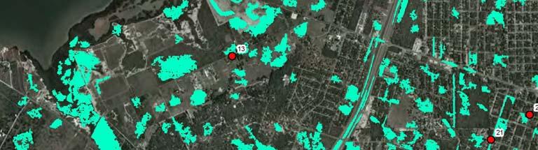
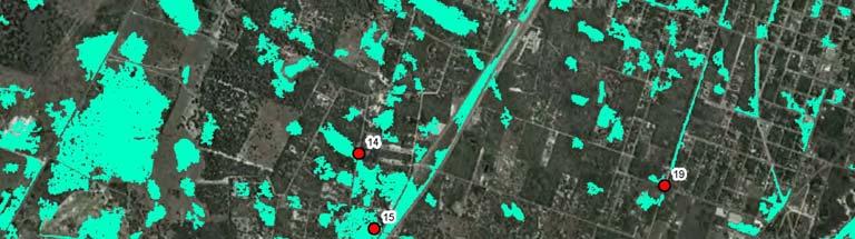

20 DRAINAGE AND FLOOD CONTROL Depressions Depth > 2 Size > 1 Acre
21 WATERSHEDS Live Oak Peninsula 23 Watersheds, 150+ Sub-basins
22 WATERSHEDS Lamar Peninsula 6 Watersheds


23 PROJECT OUTCOMES SWMP Guidance Document Drainage Criteria Manual Natural Resources Plan Stormwater Quality Plan BMP Design Criteria LID Techniques Development and Construction Guidelines (Checklist) Existing Conditions Model Flood Inundation Maps FLO2D Hydrologic Conditions Map HEC-HMS Tule Creek Watershed Project Report Blue Corridors Mapping Capital Improvement Plan


24 TULE CREEK WATERSHED REPORT Priority identified due to impacts to Little Bay, center of development, on-going work in the watershed, multi-jurisdictional H/H Water Quality Ecological Study ICPR Model Existing Conditions / Flood Mapping Sensitive areas Constraints / Opportunities Identified Several Stormwater Management Opportunities Mesquite Street Bypass West Tule Creek Sediment Pond / Channel Widening Henderson Street Tract East Tule Creek Marsh Lowering of Road Profiles Tule Park/Picton/Sorenson


25 WHERE DO WE GO FROM HERE? Prioritize Critical CIP Projects Public Input Funding Construction Prioritize Stormwater Management Opportunities Critical parcels Funding / Grants Management Continue Aransas County s Stormwater Management Principles
26 ARANSAS COUNTY STORMWATER MANAGEMENT PLAN ARANSAS PATHWAYS

27 ARANSAS PATHWAYS Aransas Pathways is a venue tax project that will increase eco-tourism within Aransas County. Approved on May 14, 2011 as a ballot initiative, the Pathways project is intended to use some of these funds to: Establish, develop, document and showcase historical sites, birding, kayaking, fishing and other nature-related, and recreational sites which will attract tourists and residents of Aransas County. Link these sites by a Countywide network of clearly marked, signed and well maintained trails, pathways, roads and sidewalks. By developing and showcasing these resources in the manner described above it is expected that tourism and commerce in the County will be enhanced. Venue tax is paid by visitors to the County. No additional taxes are required to fund the Pathways Project.

28 ARANSAS PATHWAYS
29 ARANSAS COUNTY STORMWATER MANAGEMENT PLAN QUESTIONS / COMMENTS? Linda D. Pechacek, P.E. ldp@ldpconsult.com