Hydrogeology of East Anglia An Introduction
|
|
|
- Blaze O’Brien’
- 5 years ago
- Views:
Transcription
1 East Land Quality Forum Hydrogeology of East Anglia An Introduction Richard Fry Ely Golf Club November 6 th

2 2
3 Groundwater systems are complex and difficult to assess; they are based on aquifer systems with complex and heterogeneous geologies. A particular difficulty is that groundwater cannot be seen, and groundwater flows cannot be measured directly. Thus, a comprehensive understanding of groundwater systems can only be developed through targeted investigations, long term monitoring and interpretation 3
4 So we will be looking at are: Hydrogeology Geology Groundwater Storage and Flow Primary Permeability; Secondary Permeability; Principal Aquifers; Secondary Aquifers; Hydrology Rainfall, Runoff, Interflow, Recharge; Baseflow, Springs, Swallow Holes, Blow Wells; Abstraction Ecology PWS, Agricultural, Industrial, Domestic; Contaminant Transport potential 4
5 The importance of groundwater is that it represents a vital source of water for public and private supply. Some 45% of the water delivered by the various water users within Anglian Region continues to be derived from groundwater sources and thus 55% is sourced from surface water. The main aquifer systems across the region within which, groundwater is stored are the Lincolnshire Limestone, the Greensand, the Crag and, most notably, the Chalk, and these underlie 55% of the area of the Region. 5
6 Some Useful Definitions: Aquifer - Aquiclude - Aquitard - A geological formation capable of storing and transmitting water; An impermeable geological formation incapable of transmitting water; A geological formation capable of storing water but which releases stored water slowly; Permeability - A measure of the ability of a geological formation to transmit water; Primary - Secondary - Intergranular flow; (Sandstones, Alluvial Aquifers) Fissure flow (structured formations); (Limestone, Chalk) Storage - A measure of the abstractable quantity of water stored in an aquifer system. 6
7 Groundwater Flow Governing Equation (Darcy's Law) Where: Q = Discharge (m3/day) k = Permeability (m/day) Q=kAi A = Area (through which flow takes place m2) i = Hydraulic gradient (dimensionless) Also: T = Transmissivity (m3/day/m) b = Saturated thickness (m) Since T=k/b then Q=TiL (useful for back of an envelop calcs) 7
8 Chalk & Limestone Transmissivity High GW Level m 2 /d T=k/b 8
9 Chalk & Limestone Transmissivity Low GW Level m 2 /d 9

10 Chalk & Limestone Specific Yield = Vw/Vt 10

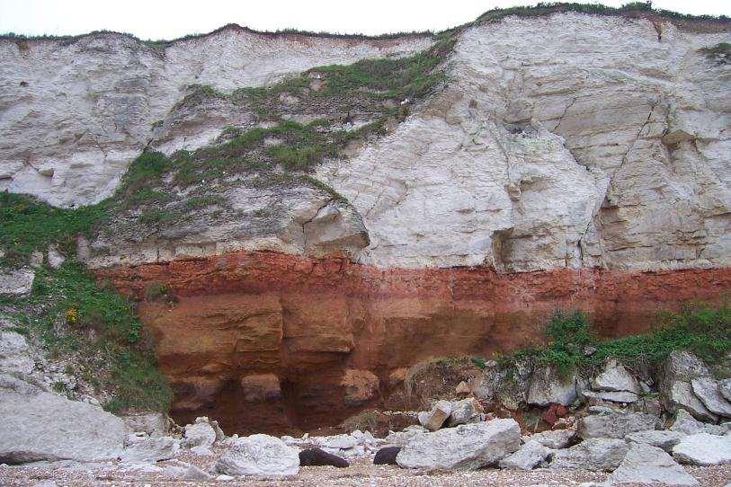
11 Geology 11

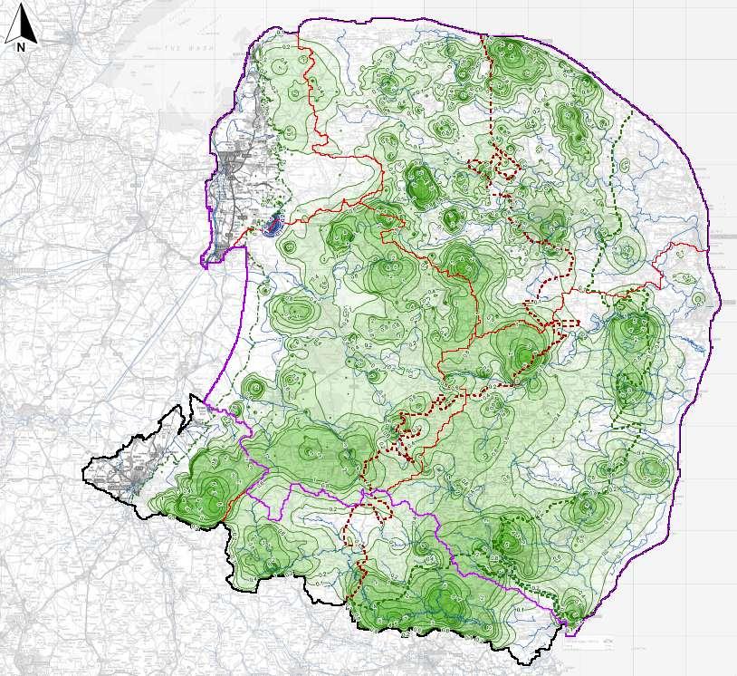
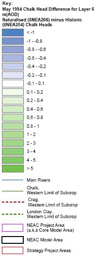
12 Cross Sections and Buried Valleys NEAC Project Area 12

13 Upper Chalk Crag London Clay Section 3a East 13

14 Drift Lower Chalk Middle Chalk Section 3.2b West 14
15 15
 G Springlines along chalk feather")
16 Hydrogeological Processes East Anglia A Recharge dominates F GW discharges to main rivers (baseflow) G Springlines along chalk feather edge 16

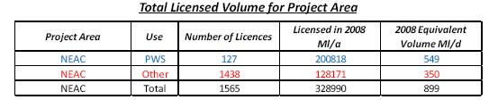
17 Hydrogeological Processes East Anglia H Till dominated area of low recharge I Stream headwaters on Till, limited to zero baseflow K Recharge dominant in Eastern Crag areas N London Clay margin, GW forced up into Crag O Restricted GW flow to East under London Clay East 17

18 Hydrology Hydrologic Cycle The Anglian Water region is one of the driest in the country, receiving on average only 600mm of rain a year 18
19 Rainfall Long term average (mm per year) 19
20 Effective rainfall (Rain Evapotranspiration) Long term average (mm per year) 20
 1961-2007 Long term average (mm per")
21 Groundwater recharge (Infiltration to aquifers) Long term average (mm per year) 21


22 Total Natural Flow, QN95 Ml/d 22

23 Congham Spring 23

24 Baseflow Influent and Effluent Streams/Rivers 24

25 Abstraction There are over 8200 boreholes, wells and springs licensed for the abstraction of groundwater in Eastern England Total licensed amount is approx Ml/d Recent actual uptake approximately, 875 Ml/d 25

26 Northern East Anglia Chalk GW Abstractions 26
27 27


28 Ecological Significance Water level Ecology Flow Chemistry Define base of wetland Define strata beneath wetland Drill to main aquifer horizon Define connection to aquifer Characterise signal attenuation Characterise signal beneath site Characterise signal at source 28

29 East Wretham Heath Dry Mere 29

30 East Wretham Heath Wet Again 30
31 Drinking Water Source Protection Zones There are 369 groundwater sources used for drinking water with source protection zones in the east of England: Most are for public water supply 31

32 Hazards to Groundwater *Groundwater Forum 32

33 Groundwater Protection *Groundwater Forum 33