Northstowe Community Forum, 19 July 2017 Alex Gallagher Technical Director, Hydrogeologist, CGeol
|
|
|
- Philip Gallagher
- 5 years ago
- Views:
Transcription

1 Northstowe Community Forum, 19 July 2017 Alex Gallagher Technical Director, Hydrogeologist, CGeol

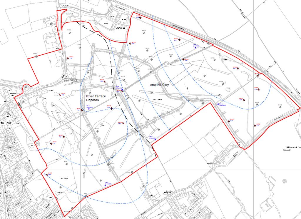
2 Northstowe location Northstowe Phase 1 Situated on the former Cambridge Golf Course and former agricultural land Northstowe Phase 1 Located to the east of Longstanton Kingfisher Pond located in west of site Longstanton Kingfisher Pond
3 Topography Western area: Underlain by River Terrace Deposits (RTD) Little topographic variation mAOD Eastern area: Underlain by Ampthill Clay Formation (ACF) Ground elevations fall to southeast Low of 5.5mAOD in southeast corner


4 Pre-development surface water catchments Western area: Small catchment Flow west into Longstanton Drain Southern and eastern area: Two main ditches Greenway A and B drain most of the site Flow east into Reynolds Drain

5 Boreholes and historical water level monitoring Comprehensive ground investigations o o o 81 geology boreholes 198 trial pits 30 groundwater monitoring locations Historic groundwater monitoring data o o Pond level monitoring o 2011 o
 in east of site o Mudstone o Relatively")
6 Surface Geology River Terrace Deposits Ampthill Clay Formation River Terrace Deposits (RTD) in west of site o North south channel o Cut down into Ampthill Clay Formation o Sand and gravel o Stores water Kimmeridge Clay Formation Ampthill Clay Formation (ACF) in east of site o Mudstone o Relatively impermeable
7 Groundwater flow
 groundwater elevation (maod) Key design principal was to maintain the base of the Greenways above the water table in the River Terrace Deposits DR-A Shallow extension of 8.")
8 Site drainage Drain elevation reference points Ref. Location note Drain Approx. point ID elevation (maod) groundwater elevation (maod) Key design principal was to maintain the base of the Greenways above the water table in the River Terrace Deposits DR-A Shallow extension of Greenway A near Kingfisher Pond DR-B Western extent of Greenway A close to BH116 east of the school DR-C Drain south of the Kingfisher Pond DR-D Western extent of Greenway B close to the geological boundary DR-E Drainage junction close to attenuation pond DR-F Eastern extent of Greenway A
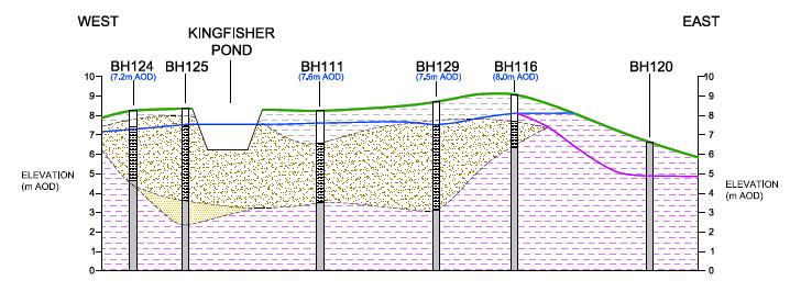
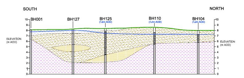
9 Geological cross-sections
10 Rainfall long term and recent Average Monthly Rainfall Cambridge NIAB Meteorological Station ( ) Month Average Monthly Rainfall (mm) 2016/2017 Monthly Rainfall (mm) January * February * March * April * May * June ** July ** August ** September ** October ** November ** December ** TOTAL Notes: * 2017, ** 2016 Unusually dry second half of 2016 and Spring 2017: 70% of long-term average rainfall (LTR) in the last 6 months off % of LTR in March and April Low rainfall limits aquifer recharge

11 Regional groundwater levels and river flows Regional groundwater levels Regional river flows Continual decline in groundwater levels since mid-2016 Low groundwater levels likely to persist into the summer due to long-term rainfall deficits River Great Ouse flows were below average in October and November 2016 and again in March and April 2017
12 Pre-dewatering groundwater elevations RTD RTD groundwater levels show seasonal variation (approx. 1m) ACF ACF groundwater levels fluctuate rapidly in response to rainfall
 Phase 1B dewatering Recovery of water levels in Kingfisher Pond afterwards (in early 2017) But low rainfall limited recharge and stopped recovery.")
13 Groundwater elevations during construction Phase 1A dewatering Groundwater elevations similar before and after Drop in water level reported in Kingfisher Pond during dewatering Water levels in pond recovered afterwards (temporary impact) Phase 1B dewatering Recovery of water levels in Kingfisher Pond afterwards (in early 2017) But low rainfall limited recharge and stopped recovery. Decline observed between March and May 2017

14 Recent monitoring Data loggers installed in three monitoring boreholes in March 2017 General decline in groundwater elevations Response to heavy rainfall on 18 May, slight recovery of groundwater levels before continuing to fall in late May
15 Summary and conclusions Comprehensive ground investigations provided accurate information upon which to base the drainage strategy The River Terrace Deposits (RTD) form a discrete aquifer that is separate to the surrounding Ampthill Clay Dewatering of the RTD for the construction of greywater drainage trenches had no long lasting effect A permanent change to the groundwater system could have occurred if: o o Grey water drainage trenches (constructed below the water table) provided a conduit to the Greenways but site inspections show that no water is seeping from the trenches which contain hydraulic barriers The main drainage ditches extended below the water table in the RTD comparison of earthworks levels with groundwater contours show that this is not the case The Autumn of 2016 and the Spring of 2017 were unusually dry: o Groundwater levels did not recover as expected during winter and spring o Regional river flows were approximately 50% of long-term average in April 2017 Climatic factors are very likely to be the cause of low water levels in the Kingfisher Pond and RTD aquifer Groundwater monitoring will continue and the situation will be reviewed in 6 months time
16 Questions?