CONTAMINATED LAND FUNDAMENTALS
|
|
|
- Amie Lester
- 5 years ago
- Views:
Transcription
1 CONTAMINATED LAND FUNDAMENTALS Hydrogeology Martin Robertson Z Energy Ltd

2 HYDROGEOLOGY AND THE CSM.


3 WATER CYCLE Groundwater is often a subdued replica of topography. Flow patterns are controlled by the need to transmit rainfall or other recharge to discharge locations such as streams, lakes and oceans.
4 CLIMATE CYCLES Climate has varied widely over time in cycles that have been correlated to variations in earths orbit. These cycles are shown in these graphs of temperature from isotopes in ice cores plotted against age in thousands of years
5 NZ Coastal Aquifers Climate cycles have resulted in large sea-level variations. Cold dry periods result in steep gravel aggradation deposits and low sea levels. Warm periods resulted in higher sea levels and deposition of fine grained sediments over the gravels forming confining layers.
6 NZ Coastal Aquifers The best aquifers are reworked gravels with a higher degree of sorting (wetter climates with limited sediment supply) In river gravels flow is generally sub-parallel to and towards water courses The less permeable the alluvium the more direct the flow towards the stream In very permeable gravels and where valleys open out from gorges groundwater flow may be away from rivers - the recharge zone south of the Hutt Valley s Taita gorge is a classic example Groundwater flow may be drawn towards shallow groundwater extraction wells Recharge areas and shallow unconfined aquifers are most vulnerable to contamination

7 Bedrock Aquifers - e.g. Greywacke or Waitemata Flow rates are often very slow The lower the rock-mass permeability the more direct flow lines are toward streams To transmit the same rainfall infiltration the gradients must be steeper Preferential flow paths such as services and drains can dominate site scale contaminant flow patterns

8 Contamination of Groundwater Many potential sources of groundwater contamination Consequently shallow aquifers are not regarded as secure for water supply but may be used for individual houses in some areas
9 Paradigm Shifts Septic tank groundwater is a resource for land treatment vs petroleum plume where unused groundwater is contaminated Landfill acceptance criteria vs contaminated site criteria soil that is okay for a residential section or kindergarten can t be deposited in a landfill. Criteria for a landfill are based on protecting drinking water and sensitive water bodies resources that don t exist where we put landfills Passive Discharges are a Legacy: it is not consenting a privilege its legalising a legacy
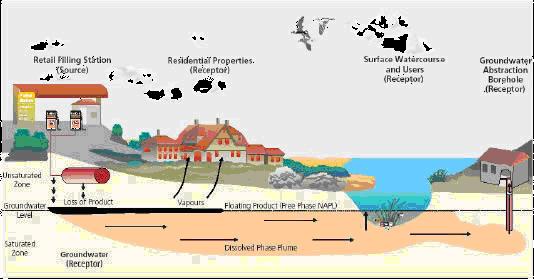
10 Conceptual Model
11 CONTAMINATION Non Volatile contaminants e.g. arsenic, lead etc 1. Ingestion of groundwater 2. Discharge to sensitive water bodies
12 CONTAMINATION Volatile contaminants e.g hydrocarbons, solvents etc 1. Ingestion of groundwater 2. Discharge to sensitive water bodies 3. Inhalation from shower water 4. Inhalation of volatiles released from the plume 5. Inhalation of volatiles from the soil and LNAPL NES does not cover groundwater but health risk from groundwater needs to be addressed. Work with Regional Councils on environmental effects
13 GROUNDWATER: RMA AND THE NES How does NES relate to volatiles from groundwater???? - Soil contamination direct health effects under NES - Groundwater discharges under RMA - Leachate or plumes evolved from contaminated soil? Has an assessment addressed the potential for environmental effects from the leaching of soil contaminants. Does the conceptual model address vapour risk to neighbouring sites? Which parts of the petroleum guidelines have been used to assess risk. Is a collaborative approach required with the Regional Council.

14 Non Volatile plume

15 PLUME EVOLUTION Plume expanding Expanding Stable Shrinking

16 HYDROCARBONS IN SUBSURFACE


17 LNAPL IS A SOIL ISSUE THERE IS NO SUBTERRANEAN VOID SOIL SAMPLES HYDROCARBON CONCENTRATIONS REFLECT AMOUNT OF LNAPL. GROUNDWATER CRITERIA ARE BASED ON DISSOLVED PHASE THERE IS NO MAGIC TO APPLY WHEN FREE PHASE IS PRESENT UNLESS YOU WANT TO REMOVE A SMALL AMOUNT OF CONSERVATISM
18 KEY POINTS Groundwater is often a subdued replica of topography Flow patterns are controlled by the need to transmit rainfall or other recharge to discharge locations such as streams Surface drainage patterns and soil types allow flow direction to be estimated when formulating conceptual site models Understanding the behaviour of contaminants in the subsurface is critical to generating a realistic CSM There is no need for gut feeling based responses to technical issues - most problems can be approximated on the back of an envelope with simple maths If anyone tells you it s complicated ask them to explain it in simple terms
19 SUPPLEMENTARY MATERIAL FOR REFLECTION The following slides provide a deep dive into some of the technical intricacies of hydrocarbon behaviour in the subsurface. Please review these in your own time and catch me on a break if you have any questions.

20 MOBILITY OF PRODUCT THROUGH SOIL Initially product flows through and the extent of impact expands Product becomes trapped in the pores and leaves a residual saturation behind Product becomes immobilised in the presence of water - oil globules have a surface tension that keeps them round and force is required to distort the globules through water wet pores - You can observe this by comparing the behaviour of water on a waxed car bonnet (round droplets caused by interfacial tension) and an unwaxed car.

21 EVOLUTION OF A RELEASE Stained hydrocarbon showing how a residual is left behind as the plume migrates. For a finite release the mobile mass diminishes until the product is immobilised.
 At this red line the concentration does not increase.")
22 VAPOUR / PLUMES AND LNAPL Dissolved concentration increases in proportion to total soil concentration up to a point (saturation point or solubility limit) At this red line the concentration does not increase. Each sample has the same dissolved concentration despite increasing soil concentrations and LNAPL

23 RAOULT S LAW If petrol LNAPL is present then less benzene can dissolve in to the water than if pure benzene LNAPL was present models used in guidelines are conservative
24 Back of an Envelope + Simple Maths Interactive exercise how much soil to contaminate a sand aquifer for 20 years If a household consumes 300 litres per day. How much water is that in 1 year About (100,000 times 0.01) 1000 mg 300 x 365 lets say about 100,000 litres So how much benzene is needed to contaminate a years water to 0.01mg/l The soil criteria for protection of groundwater in a sand is 0.17mg/kg (or about 1 mg per 5 kg) how much soil at this level of contamination is needed to provide 1000 mg About 5000 kg (say 5 times 0.17 to get 1 mg and then times 1000) that s 5 tonne If the exposure duration is 20 years and we ignore natural breakdown how much soil then?
25 PROTECTION OF GROUNDWATER CRITERIA ARE NOT ABOUT HOT-SPOTS THEY ARE ABOUT SIGNIFICANT AREAS OF SOIL IMPACT Sandy Silt soil household water 300 a day say a year Insufficient yield No need for gut reaction to dominate assessments simple maths can indicate the likelihood of an issue before delving into complex modelling. at 0.01 mg/l benzene 1000 mg to contaminate water for a year mg/kg in soil at guideline level kg of soil must be contaminated 35 tonne 22 m3 220 m3 for 10 years 440 m3 for 20 years exposure Clay soil household water 300 a day say a year - barely plausible Insufficient yield at 0.01 mg/l benzene 1000 mg to contaminate water for a year mg/kg in soil at guideline level kg of soil must be contaminated 1754 tonne 1100 m m3 for 10 years m3 for 20 years exposure - totally implausible
26 Service Station Soil Removal Volumes Graph of volumes of soil removed at tank removals by one NZ Oil Company (note conservative observational field screening adopted tends to increase volumes) The soil acceptance criteria assumptions in guidelines must be validated against the conceptual site model The collective experience is that only rarely is there widespread impact to the extent modelled in the guidelines.