Maine s Land Use Regulations and Erosion Control Techniques
|
|
|
- Howard Ryan
- 5 years ago
- Views:
Transcription


1 Maine s Land Use Regulations and Erosion Control Techniques Protecting Maine s Air, Land and Water Colin Clark colin.a.clark@maine.gov Tom Gilbert thomas.gilbert@maine.gov Jim Rodrigue james.n.rodrigue@maine.gov Maine s Land Use Regulations Erosion and Sedimentation Control Law Stormwater Law Protection and Improvement of Waters Act Natural Resources Protection Act 1


2 Erosion and Sedimentation Control Law 420-C. Erosion and sedimentation control A person who conducts, or causes to be conducted, an activity that involves filling, displacing or exposing soil or other earthen materials shall take measures to prevent unreasonable erosion of soil or sediment beyond the project site or into a protected natural resource as defined in section 480-B. Erosion control measures must be in place before the activity begins. Measures must remain in place and functional until the site is permanently stabilized. Adequate and timely temporary and permanent stabilization measures must be taken and the site must be maintained to prevent unreasonable erosion and sedimentation Erosion Control Installation 2


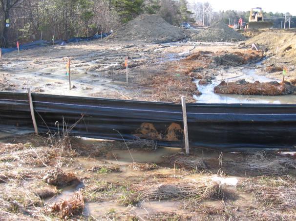
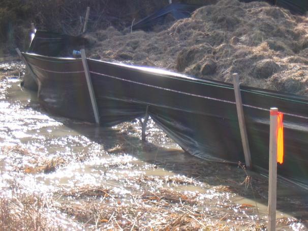
3 Is a sedimentation control Works by ponding water and allowing the soil to settle out Needs to be keyed into the soil Needs to be installed along the contour SILT FENCE 3
4 4


5 EROSION CONTROL MIX Is heavy organic material May Include stump grindings, composted bark, shredded bark, flume grit, and rocks <4. May NOT Include Wood chips, bark chips, construction debris, or reprocessed wood products 5


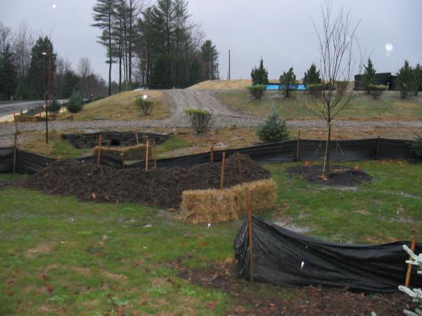
6 SOCKS Are filled with erosion control mix or mulch, Are staked in along contours, Are often used in conjunction with silt fence. EROSION CONTROL MULCH Two methods Erosion control mulch should be 3-4 inches thick and no visible exposed soil Over seed, should be a lighter application, 2 bales /1000sqft, and 75-90% coverage 6

7 Before After 7


8 Protection and Improvement of Waters Act Section 413 Prohibits discharge of all pollutants, including soil 8
 of impervious area on")


9 Stormwater Permit by Rule (PBR) Need to obtain a Stormwater PBR if disturbing 1 acre or more of area on a project site in any watershed Full Stormwater Permit Need to obtain a Full Stormwater Permit for creation of 1 acre (since 2005) of impervious area on a project site in most watersheds. (20,000 square feet in watersheds most at risk from new development). Single family houses and driveways generally do not count towards impervious thresholds. Subdivision access roads do count!! Activities that require a permit: Alteration within 75 feet of a resource: Bulldozing, dredging, removing or displacing soils, sand, vegetation and other materials Placing fill in a resource Draining or dewatering a resource Construction, repair, or alteration of any permanent structure in a resource 9


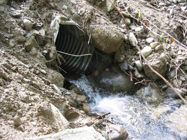
10 Natural Resources Protection Act (NRPA) Rivers, Streams, and Brooks Lakes (great ponds) Freshwater Wetlands Coastal Wetlands Significant Wildlife Habitat EXEMPTIONS Maintenance and Repair, including culverts Minor alterations in freshwater wetlands Public Works Projects Temporary Structures Removal of Beaver Dams Many others Note: Exemptions apply only when Erosion Control Measures are used! CULVERT REPLACEMENT EXEMPT IF: Erosion controls used Do not block fish passage Installed to match natural grade to avoid drops or perching Embedded in stream minimum of 1 foot or 25% Diameter (MAX 2 feet) 10
11 Public Works Projects No additional intrusion into the resource Erosion control measures must be utilized Can t block fish passage Does not apply to an outstanding river segment REMOVAL OF BEAVER DAMS Authorized by a Game Warden Efforts are made to minimize erosion Efforts are made to minimize the alteration of the undisturbed portion of the wetland Wheeled or tracked may only be operated in the water for crossing or dam removal TEMPORARY STRUCTURES In place less than 7 months a year Fill is never temporary Still can t cause a discharge Temporary bridges and wood mat bridges do not need permits 11


12 Rivers, Streams, and Brooks Must have a defined channel and have at least 2 of the following: mapped on U.S.G.S. topo map flow 6 months per year scoured mineral bed aquatic organisms aquatic vegetation Rivers, Streams and Brooks What would you say? IF STREAM IS DRY PERMIT STILL REQUIRED 12


13 Lakes (Great Ponds) >10 acres natural >30 acres manmade Must have: wetland hydrology hydric soils Freshwater Wetlands wetland plants NOTE: NRPA recognizes the 1987 Corps of Engineers Wetlands Delineation Manual for delineating wetland boundaries Freshwater Wetlands 13


14 Open Water / Emergent Vegetation Wetlands Forested Wetlands A forested wetland is a wetland dominated by woody vegetation 6 meters tall or taller Coastal Wetlands Include areas: All areas located below The Highest Annual Tide (HAT) with vegetation tolerant of salt water Coastal wetlands may include portions of Coastal Sand dunes 14


15 Significant Wildlife Habitat Fast and easy permitting process For a project to qualify for Permit-by-Rule, it must be designed and constructed in compliance with all applicable Chapter 305 Rules Permit-by-Rule Section 2 Applies to any activity within 75 feet of a protected natural resource Activities such as soil disturbance and additions to existing structures require approval from the Department 15
16 Permit-by-Rule Section 2 All activities must: Avoid and minimize the alteration within 75 feet of the resource Be at least 25 feet from the edge of the resource Utilize erosion control devices Permit By Rule Section 2: Activities adjacent to protected natural resources APPLICABILITY Section 2 applies to activities adjacent to, but not in: Coastal wetlands Great Ponds River, stream or brook Freshwater wetlands containing at least 20,000 ft 2 of open water, aquatic or emergent marsh vegetation Peatlands Significant wildlife habitat contained within a freshwater wetland Permit By Rule Section 2: Activities adjacent to protected natural resources SUBMISSIONS The applicant is required to send the following submissions with this section: 1. Photographs of the area affected 2. A brief narrative: Explaining why there is no practicable alternative to locating the activity within 75 feet of the resource Explaining how the impact on the remaining buffer will be minimized Is not required for activities presumed to have no practicable alternative as listed in the STANDARDS section 16

17 Permit By Rule Section 2: Activities adjacent to protected natural resources SUBMISSIONS (cont.) 3. A scaled plan or drawing of the area affected including: Entire property on which the activity is proposed, including: Property lines 75 foot setback lines Boundaries or location of protected natural resources Proposed & Existing Development including buildings, parking areas, roads, fill areas, landscaped areas, etc. Any site constraints limiting development beyond the 75 foot setback, such as steep slopes *It is not necessary to have a plan professionally prepared. However, it should be legible and drawn to scale allowing clear representation of distances and measurements on the plan. Scaled plan Narrative Single Family Dwelling and associated construction at 75 Resource Drive in the Town of Permitville. The proposed construction and associated fill material cannot be located outside the 75 foot setback of the stream because of Town restrictions, topography restraints (steep slopes) and freshwater wetland. The Town of Permitville requires a property side setback of 10 feet and a 20 foot road set back to Resource Drive. Furthermore, the proposed driveway can be no less than 24 feet in width to meet town fire codes. There is a steep slope on my property in the northeastern corner that would require the dwelling to be constructed in the freshwater wetland and within 25 feet of the unnamed stream. Therefore, impact to the 75 foot stream buffer would be minimized to the greatest extent practicable with this proposal. 17


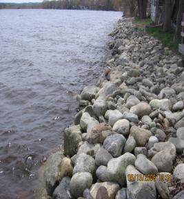
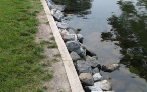
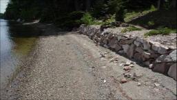
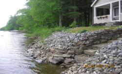
18 Permit-by-Rule Section 8 Applicability Applies to the establishment of vegetation adjacent to any resource and the installation of riprap along the shoreline of a great pond, freshwater wetland, stream, or brook Applies only to areas where erosion exists and vegetation is not present This section does not apply to shoreland zoned rivers a riprap project that affects more than 100 feet of shoreline. a riprap project that is adjacent to a coastal wetland or within any portion of a coastal sand dune system. Riprap. Heavy, irregularly-shaped rocks that are fit into place, without mortar, on a slope. Square or rectangular rocks with flat faces, such as quarry stone or manufactured blocks, do not qualify as irregularly-shaped. Permit By Rule Section 8: Shoreline stabilization SUBMISSIONS 1. Photographs of the entire shoreline area where the activity is proposed 2. Professional design plans for riprap on streams and brooks 3. A scaled drawing, including a cross section, of the proposed riprap installation. The drawing must clearly depict the extent of riprap proposed to be installed, such as the length along shore and height above the normal high water line. Riprap = Heavy, irregularly-shaped rocks that are fit into place, without mortar, on a slope ACCEPTABLE UNACCEPTABLE 18


19 Permit By Rule Section 8: Shoreline stabilization Standards Riprap may be utilized only where eroded slopes exceed 3 horizontal feet to 1 vertical foot eroded slopes that are shallower than 3 to 1 vegetation must be used to stabilize the slope Riprap installed on a Great Pond, Open water wetland, River, Stream, or Brook may not extend higher than 2 feet above the normal high water line Rocks used for riprap may not be obtained from the shoreline (because they help prevent erosion) or below the normal high water line (because they provide habitat for aquatic life). The slope of the riprap may not be steeper than 1 horizontal to 1 vertical, nor shallower than 3 horizontal to 1 vertical. Permit By Rule Section 8: Shoreline stabilization Standards Riprap must be anchored at the base of the existing bank by trenching in the bottom course of rock or pinning the riprap to the ledge Filter fabric, crushed stone, washed gravel must be placed under the riprap to prevent soil loss Riprap may not be placed in front of a retaining wall Wheeled or tracked vehicles may not operate in the water Disturbance of vegetation must be avoided. If Vegetation is disturbed then it must be reestablished immediately upon completion of the activity. COASTAL THE GOOD BEFORE AFTER 19


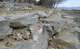
20 INLAND THE GOOD BEFORE AFTER THE BAD BEFORE AFTER ENFORCEMENT PENDING CREATING WALLS ON: INFRONT OF RETAINING WALL COASTAL WETLANDS TOO HIGH ON A GREAT POND GREAT PONDS 20
 Culverts Must provide fish passage")
21 Permit by Rule Section 10 Stream Crossings (Bridges, Culverts, Fords) STREAM CROSSINGS Fill slopes must be stabilized 3 times the cross sectional area stream channel is required for culverts and bridges Surface water must be diverted through buffer areas If working in less than 3 of water must divert water around work area STREAM CROSSINGS (Continued) Culverts Must provide fish passage follow alignment and grade of stream be placed at or below streambed back fill must be compacted Slopes must be riprapped 21


22 THE GOOD THE BAD THE UGLY 22


23 Summary Erosion control devices must be installed on ALL project sites to prevent soil loss All activities in or within 75 feet of a resource may require a NRPA permit Stormwater Permit required for >1 acre disturbed, >1 acre impervious, >20,000 sf impervious in watershed most at risk. Remember... If you have any questions about your project site or whether a permit is required CALL US! On Call Line: or Colin Jim Tom Southern Maine Region Eastern Maine Region Northern Maine Region
Maine s Environmental Laws Protect Our Natural Resources
 Maine s Environmental Laws Protect Our Natural Resources Maine s Land Use Regulations Protection and Improvement of Waters Act Erosion and Sedimentation Control Law Stormwater Management Law Site Location
Maine Department of Environmental Protection (DEP)
") Maine Department of Environmental Protection (DEP) By Cameron Adams Southern Maine Region 312 Canco Road, Portland (207)822-6300 Main Office and Central Maine Region 28 Tyson Drive, Augusta (207)287-7688
Maine Department of Environmental Protection (DEP) By Cameron Adams Southern Maine Region 312 Canco Road, Portland (207)822-6300 Main Office and Central Maine Region 28 Tyson Drive, Augusta (207)287-7688
No. 6 December, Wisconsin s Forestry Best Management Practices for Water Quality Forest Roads
 No. 6 December, 1995 Wisconsin s Forestry Best Management Practices for Water Quality Forest Roads Steve Holaday, Wisconsin Dept. of Natural Resources, and Jeff Martin, Dept. of Forestry, UW-Madison BMPs
Typical Local Erosion Control Requirements (Storm Water Management Authority, Inc.)
") Module 2: Selection of Controls and Site Planning for Construction Site Erosion Prevention Robert Pitt Department of Civil, Construction, and Environmental Engineering University of Alabama Tuscaloosa,
Module 2: Selection of Controls and Site Planning for Construction Site Erosion Prevention Robert Pitt Department of Civil, Construction, and Environmental Engineering University of Alabama Tuscaloosa,
Shoreland Protection Innovative Model Ordinance
 Shoreland Protection Innovative Model Ordinance Southern New Hampshire Planning Commission September 14, 2007 Innovative Land Use Guide Training Presented By: Jack Munn, Senior Planner, SNHPC For Questions
The Construction General Permit and Erosion Prevention and Sedimentation Control
 The Construction General Permit and Erosion Prevention and Sedimentation Control Presented at the Tennessee Gas Association Conference April 23, 2008 More than thirty years ago, two-third of the nation's
SHORELAND PROTECTION PERMIT APPLICATION
 SHORELAND PROTECTION PERMIT APPLICATION CODE ENFORCEMENT OFFICE 85 UNION STREET BRUNSWICK, MAINE 04011 (207) 725-6651 FAX (207) 725-6663 For Office Use Appl # Date Fee MAP LOT Appr By GENERAL INFORMATION
Standards for Soil Erosion and Sediment Control in New Jersey May 2012 STANDARD FOR SLOPE PROTECTION STRUCTURES. Definition
 STANDARD FOR SLOPE PROTECTION STRUCTURES Definition Structures to safely conduct surface runoff from the top of a slope to the bottom of the slope. Purpose The purpose of this practice is to convey storm
Larimer County Land Use Code Section 5.8: Rural Land Use Process
 Larimer County Land Use Code Section 5.8: Rural Land Use Process 5.8.6 PRINCIPLES D. Development Standards 3. Engineering Standards and Guidelines for Roads and Drainage The following Standards and Guidelines
Erosion and Sediment Pollution Control Guidelines for Residential Lots with soil disturbance of less than 1 acre (see exceptions)
") Adams Co. Conservation District 670 Old Harrisburg Road, Suite 201 Gettysburg, PA 17325 Telephone: 334-0636 Fax: 337-0730 www.adamscounty.us Erosion and Sediment Pollution Control Guidelines for Residential
Adams Co. Conservation District 670 Old Harrisburg Road, Suite 201 Gettysburg, PA 17325 Telephone: 334-0636 Fax: 337-0730 www.adamscounty.us Erosion and Sediment Pollution Control Guidelines for Residential
COWLITZ COUNTY DEPARTMENT OF BUILDING AND PLANNING
 COWLITZ COUNTY DEPARTMENT OF BUILDING AND PLANNING GENERAL GRADING REQUIREMENTS GRADING STANDARDS Unless otherwise recommended in a soils engineering or engineering geology report, approved by the County,
Town of Essex, Vermont January, 2017 Standard Specifications For Construction CHAPTER 3 EROSION AND SEDIMENT CONTROL
 CHAPTER 3 EROSION AND SEDIMENT CONTROL CHAPTER 3 EROSION AND SEDIMENT CONTROL Section 300 General Summary All projects constructed within the Town of Essex shall be constructed in strict accordance with
CHARLES SOIL CONSERVATION DISTRICT COMPLIANCE AGREEMENT FOR THE STANDARD EROSION AND SEDIMENT CONTROL PLAN FOR FOREST HARVEST OPERATIONS
 CHARLES SOIL CONSERVATION DISTRICT COMPLIANCE AGREEMENT FOR THE STANDARD EROSION AND SEDIMENT CONTROL PLAN FOR FOREST HARVEST OPERATIONS I. Site Information A. Location (Include site map of harvest area)
Storm Water Pollution Prevention Plan (SWP3) Checklist
 Checklist") . Summit Soil and Water Conservation District Storm Water Pollution Prevention Plan (SWP3) Checklist Modified from the Ohio EPA SWP3 Checklist (Revised January 2017) SITE NAME: REVIEWER: DATE RECEIVED:
. Summit Soil and Water Conservation District Storm Water Pollution Prevention Plan (SWP3) Checklist Modified from the Ohio EPA SWP3 Checklist (Revised January 2017) SITE NAME: REVIEWER: DATE RECEIVED:
Single Family Residential Construction Erosion/Sediment Control Standards
 Single Family Residential Construction Erosion/Sediment Control Standards Introduction: This booklet contains standard plans and procedures sufficient for typical building construction. It is not intended
GRADING, EROSION AND SEDIMENTATION CONTROL
 SECTION 500 GRADING, EROSION AND SEDIMENTATION CONTROL 501 Erosion and Sedimentation Control Plan All engineering plans for projects that propose to construct new, or modify existing drainage facilities,
Chapter 5: Water Quality Buffer Requirements
 Chapter 5: Water Quality Buffer Requirements 5.1 Introduction Water quality buffer requirements apply to all new land development or redevelopment containing streams or other water bodies such as ponds,
Appendix K: Soil Erosion and Sedimentation Control Plan Check List
 Appendix K: Soil Erosion and Sedimentation Control Plan Check List Drain Commissioner 46 February 2005 SOIL EROSION AND SEDIMENTATION CONTROL PLAN CHECK LIST Items listed below must be clearly depicted
Slash Water Bar Video
 Slash Water Bar Video Water Bars Advantages Low cost for materials Use on site materials Disadvantages Not for active haul roads Can be damaged by ATV s and follow up users Broad-based Dip Long enough
TOWN OF SMYRNA Water Quality Buffer Zone Policy
 TOWN OF SMYRNA Water Quality Buffer Zone Policy Section I - Description A water quality buffer zone (a.k.a. a riparian zone) is a strip of undisturbed native (indigenous) vegetation, either original or
R I Freshwater Wetlands Buffer Zones
 R I Freshwater Wetlands Buffer Zones November 21, 2013 Chuck Horbert RIDEM Freshwater Wetlands Buffer Zone Defined Means an area of undeveloped vegetated land retained in its natural undisturbed condition,
2-16 EROSION, SEDIMENT & STORM WATER CONTROL REGULATIONS APPENDIX B1
 2-16 EROSION, SEDIMENT & STORM WATER CONTROL REGULATIONS APPENDIX B1 There are three ways to accomplish urban soil erosion and sedimentation control: Allow erosion to take place and then control sediment
Understanding Stormwater Pollution Prevention Plans (SWPPPs) (SWPPPS)
 (SWPPPS)") Understanding Stormwater Pollution Prevention Plans (SWPPPs) (SWPPPS) Definitions SWPPP: Storm Water Pollution Prevention Plan BMP: Best Management Practice(s) to control pollution IDNR: Iowa Department
Understanding Stormwater Pollution Prevention Plans (SWPPPs) (SWPPPS) Definitions SWPPP: Storm Water Pollution Prevention Plan BMP: Best Management Practice(s) to control pollution IDNR: Iowa Department
STANDARD GRADING AND SOIL EROSION & SEDIMENT CONTROL PLAN FOR SINGLE LOT SINGLE FAMILY RESIDENTIAL CONSTRUCTION AND MINOR EARTH DISTURBANCES
 DIVISION OF ENGINEERING & CONSTRUCTION MANAGEMENT PLAN REVIEW DEPARTMENT WASHINGTON COUNTY SOIL CONSERVATION DISTRICT 1260 Maryland Avenue, Suite 101 Hagerstown, MD 21740 Telephone: (301) 797-6821, Ext.
E & S Plan Approved. Not required but may be a municipal requirement** Not required but may be a. municipal. requirement** Not required but may be a
 Disturbed Area 0-5000 Sq. ft 5000 Sq. ft to less than 1 acre 1 to
Water Resources Program.
 POCKET GUIDE Water Resources Program http://tfsweb.tamu.edu/bmp Texas Forestry Best Management Practices Pocket Guide August 2017 This guide was financed in part (60%) by a 319 (h) grant from the U.S.
U.S. ARMY CORPS OF ENGINEERS. Little Rock District
 U.S. ARMY CORPS OF ENGINEERS Little Rock District SEDIMENT AND EROSION CONTROL GUIDELINES FOR PIPELINE PROJECTS Table of Contents 1.0 INTRODUCTION... - 1-2.0 PROJECTS IN WATERS OF THE UNITED STATES...
Best Management Practice (BMP) Guidance Manual
 Guidance Manual") Best Management Practice (BMP) Guidance Manual INTRODUCTION BMP examples in this guide provide ways to meet erosion and sediment control requirements. Best Management Practices are not limited to these
Best Management Practice (BMP) Guidance Manual INTRODUCTION BMP examples in this guide provide ways to meet erosion and sediment control requirements. Best Management Practices are not limited to these
Warner Robins Stormwater Local Design Manual
 Warner Robins Stormwater Local Design Manual Prepared for Houston County City of Warner Robins City of Perry City of Centerville May 17, 2005 Version 4 (As presented with adopted Stormwater Ordinance)
Buffer Zones. November 29, RIDEM Freshwater Wetlands
 R I Freshwater Wetlands Buffer Zones November 29, 2012 Chuck Horbert RIDEM Freshwater Wetlands Buffer Zone Defined Means an area of undeveloped vegetated land retained in its natural undisturbed condition,
Stormwater Erosion Control & Post-Construction Plans (Stormwater Quality Plans)
") Stormwater Erosion Control & Post-Construction Plans (Stormwater Quality Plans) Allen County Stormwater Plan Submittal Checklist The following items must be provided when applying for an Allen County Stormwater
Stormwater Erosion Control & Post-Construction Plans (Stormwater Quality Plans) Allen County Stormwater Plan Submittal Checklist The following items must be provided when applying for an Allen County Stormwater
Construction Site Erosion Control and Phase II of the Stormwater Permit Program
 Construction Site Erosion Control and Phase II of the Stormwater Permit Program Robert Pitt Department of Civil and Environmental Engineering University of Alabama Tuscaloosa, AL Some Features of Phase
Storm Water Permitting Requirements for Construction Activities. John Mathews Storm Water Program Manager Division of Surface Water
 Storm Water Permitting Requirements for Construction Activities John Mathews Storm Water Program Manager Division of Surface Water Why Permit Storm Water? Impacts During Construction Not an issue until
Chapter 3 Dispersion BMPs
 Chapter 3 Dispersion BMPs 3.1 BMP L611 Concentrated Flow Dispersion 3.1.1 Purpose and Definition Dispersion of concentrated flows from driveways or other pavement through a vegetated pervious area attenuates
Rock Sock (RS) Rock Sock height.
 Rock Sock height.") Rock Sock (RS) SC-5 Description A rock sock is constructed of gravel that has been wrapped by wire mesh or a geotextile to form an elongated cylindrical filter. Rock socks are typically used either as
Rock Sock (RS) SC-5 Description A rock sock is constructed of gravel that has been wrapped by wire mesh or a geotextile to form an elongated cylindrical filter. Rock socks are typically used either as
Appendix E : Guidelines for Riparian Buffer Areas
 Appendix E : Guidelines for Riparian Buffer Areas This document should be read in conjunction with the CRCA Planning Policy. 1.0 PURPOSE The purpose of this document is to summarize the recommendations
AMENDMENTS TO BAYFIELD COUNTY ZONING ORDINANCE. Lake Superior Shoreland Lot Development Requirements.
 AMENDMENTS TO BAYFIELD COUNTY ZONING ORDINANCE Sec. 13-1-34 is created to read as follows: Sec. 13-1-34 Lake Superior Shoreland Lot Development Requirements. Introduction. Much of Bayfield County s Lake
Stormwater Management. Cayuga County NY 20 July 2016 Presenter : John B. Zepko, CPESC
 Stormwater Management Cayuga County NY 20 July 2016 Presenter : John B. Zepko, CPESC Agenda What is Stormwater? Why is Stormwater a Problem? NY State Regulations Stormwater Pollution Prevention Plans What
Stormwater Local Design Manual For Houston County, Georgia
 Stormwater Local Design Manual For Houston County, Georgia Adopted November 15, 2005 TABLE OF CONTENTS 1. FORWARD... 1 2. GENERAL LEVEL OF SERVICE STANDARDS... 2 2.1. DETENTION REQUIREMENTS... 2 2.1.1.
Funding Guidelines State Fiscal Year 2016
 State Fiscal Year 2016 Water Quality Financial Assistance Centennial Clean Water Program Clean Water Act Section 319 Program Stormwater Financial Assistance Program Washington State Water Pollution Control
ADDENDUM NUMBER TWO. A. SECTION ADVERTISEMENT FOR BIDS 1. REVISE Sealed Bid Date/Time/Location paragraph to read as follows:
 DIVISION 00 - PROCUREMENT AND CONTRACTING REQUIREMENTS SECTION 00 91 11.02 ADDENDUM NUMBER TWO June 22, 2016 TO: PLANHOLDERS SUBJECT: PCT TRUCK STAGING PROJECT PROJECT NO. 091606 CONTRACT NO. 070287 This
Appendix B Construction SWPPP Short Form
 Appendix B Construction SWPPP Short Form Projects falling within the thresholds listed below may use this short form instead of preparing a formal Construction Stormwater Pollution Prevention Plan (SWPPP).
Schedule A DISTRICT OF MAPLE RIDGE Watercourse Protection Bylaw
 Schedule A DISTRICT OF MAPLE RIDGE Watercourse Protection Bylaw 6410 2006 The Erosion and Sediment Control plan should seek (i) to protect the soil surface from erosion where possible and (ii) capture
Phase II: Proposed (regulated) Impervious in disturbed area (ac) Long Lake Existing Impervious in disturbed area (ac)
 Impervious in disturbed area (ac) Long Lake Existing Impervious in disturbed area (ac)") Permit Application No.: 17-181 Rules: Erosion Control, Wetland Protection, and Waterbody Crossings & Structures Applicant: Hennepin County Received: 4/27/17 Project: CSAH 112 Phase II Complete: 9/5/17
Permit Application No.: 17-181 Rules: Erosion Control, Wetland Protection, and Waterbody Crossings & Structures Applicant: Hennepin County Received: 4/27/17 Project: CSAH 112 Phase II Complete: 9/5/17
4. Ponds and infiltration BMPs can achieve 60 to 100% removal efficiencies for sediment.
 Landscape BMPs For the purposes of this project, preventive measures have been categorized into two categories: landscape BMPs and source prevention BMPs. Landscape BMPs includes both vegetative practices
Ponds. Pond A water impoundment made by excavating a pit, or constructing a dam or an embankment.
 POND SITE SELECTION AND CONSTRUCTION Uses, Planning, & Design David Krietemeyer Area Engineer USDA-NRCS June 20, 2008 Uses Considerations for Location of Commonly Used Terms Pond A water impoundment made
STANDARD PLAN FOR MINOR EARTH DISTURBANCES
 Allegany Soil Conservation District 12407 Naves Cross Road, NE Cumberland, MD 21502 Phone: 301.777.1747 Fax: 301.777.7632 Permit #: Allegany County City of Cumberland City of Frostburg Other Date: STANDARD
EROSION AND SEDIMENTATION CONTROL SECTION 1 - GENERAL 1.1 SUMMARY
 31 25 00 EROSION AND SEDIMENTATION CONTROL SECTION 1 - GENERAL 1.1 SUMMARY A. Erosion and sedimentation control shall be provided by the Contractor for all areas of the site denuded or otherwise disturbed
SECTION B. Prevention of sedimentation of waterways, open drainage ways, and storm and sanitary sewers due to construction activities.
 SECTION 01 5713 TEMPORARY EROSION AND SEDIMENT CONTROL PART 1 GENERAL 1.01 SECTION INCLUDES A. Prevention of erosion due to construction activities. B. Prevention of sedimentation of waterways, open drainage
Erosion Control Inspection Form
 Project Name Address Inspection Date Time Name of Certified Erosion Sediment Lead (CESCL) or qualified inspector if less than one acre Print Name: Approximate rainfall amount since the last inspection
Instructions for Notice of Ground Disturbance Form:
 Instructions for Notice of Ground Disturbance Form: Prior to beginning any ground disturbance activity or finalizing your storm water plan, submit a completed 2 page Notice of Ground Disturbance Form to
Suggested Stormwater Management Practices For Individual House Lots
 Suggested Stormwater Management Practices For Individual House Lots These practices are necessary to satisfy the water quantity and water quality criteria of the Rappahannock Stormwater Ordinance. These
Environmental Check List Georgia Environmental Policy Act
 Environmental Check List Georgia Environmental Policy Act Project No. : Project Name: GEORGIA IS AREA AFFECTED? IF AFFECTED, HOW SEVERELY? AREA/CATEGORY NO YES UNKNOWN MINOR MEDIAN MAJOR UNKNOWN 1. Wetlands
Section 208. SOIL EROSION AND SEDIMENTATION CONTROL
 208.01 Section 208. SOIL EROSION AND SEDIMENTATION CONTROL 208.01. Description. This work consists of installing and maintaining erosion and sedimentation controls to minimize soil erosion and control
BLOCKING AND FILLING SURFACE DRAINAGE DITCHES
 MINNESOTA WETLAND RESTORATION GUIDE BLOCKING AND FILLING SURFACE DRAINAGE DITCHES TECHNICAL GUIDANCE DOCUMENT Document No.: WRG 4A-1 Publication Date: 10/14/2015 Table of Contents Introduction Application
Chapter 2: Selecting Best Management Practices (BMPs)
") Chapter 2: Selecting Best Management Practices (BMPs) 2.1 - Temporary versus Permanent BMPs The same level of care should be taken to select both temporary BMPs and permanent BMPs. The same level of care
Chapter 2: Selecting Best Management Practices (BMPs) 2.1 - Temporary versus Permanent BMPs The same level of care should be taken to select both temporary BMPs and permanent BMPs. The same level of care
October 2016 CDRPC Workshop
 The New Blue Book NYS Standards and Specifications for Erosion and Sediment Control Dated July 2016 October 2016 CDRPC Workshop Blue Book Update Overview Reorganization of standard to reflect recommended
Blue Book Update Overview
 The New Blue Book NYS Standards and Specifications for Erosion and Sediment Control Dated July 2016 October 2016 CDRPC Workshop Blue Book Update Overview Reorganization of standard to reflect recommended
Operating and Reclamation Plan
 Operating and Reclamation Plan For sites in sensitive locations, additional information may be required. If more space is needed, attach additional sheets or use the blank sheet provided at the end of
SECTION EROSION AND SEDIMENTATION CONTROLS
 SECTION 312500 PART 1 GENERAL 1.01 GENERAL REQUIREMENTS A. Attention is directed to the CONTRACT AND GENERAL CONDITIONS and all Sections within DIVISION 01 - GENERAL REQUIREMENTS which are hereby made
MODEL Stormwater Local Design Manual. City of Centerville
 MODEL Stormwater Local Design Manual City of Centerville Adopted December 6, 2005 TABLE OF CONTENTS 1. FORWARD... 1 2. GENERAL LEVEL OF SERVICE STANDARDS... 1 2.1. DETENTION REQUIREMENTS... 1 2.1.1. Discharge
Ordinance No Lot Surface Drainage
 Ordinance No. 35-2008 - Lot Surface Drainage The Township has adopted a new Lot Surface Drainage Ordinance which amends Chapter 170, Article IX, Subdivision and Site Plan Review by adding a new Section
Construction Site Erosion Control and Phase II of the Stormwater Permit Program
 Construction Site Erosion Control and Phase II of the Stormwater Permit Program Robert Pitt Department of Civil, Construction, and Environmental Engineering University of Alabama Tuscaloosa, AL In Georgia,
Town of Friday Harbor PO Box 219 / Friday Harbor / WA / (360) / fax (360) /
 / fax (360) /") Town of Friday Harbor PO Box 219 / Friday Harbor / WA / 98250 (360) 378-2810 / fax (360) 378-5339 / www.fridayharbor.org LAND CLEARING, GRADING, OR FILLING PERMIT APPLICATION APPLICATION DATE GRD No. APPLICANT/FRANCHISE
Town of Friday Harbor PO Box 219 / Friday Harbor / WA / 98250 (360) 378-2810 / fax (360) 378-5339 / www.fridayharbor.org LAND CLEARING, GRADING, OR FILLING PERMIT APPLICATION APPLICATION DATE GRD No. APPLICANT/FRANCHISE
Construction Site Erosion Control and Phase II of the Stormwater Permit Program
 Construction Site Erosion Control and Phase II of the Stormwater Permit Program Robert Pitt Department of Civil, Construction, and Environmental Engineering University of Alabama Tuscaloosa, AL In Georgia,
Will County Site Development Permit Submittal Checklist TAB 1 PROJECT OVERVIEW
 Applicant: Reviewer: Permit No.: The following tables contain a checklist of the requirements before a review for a Site Development Permit submittal will be accepted. Not all requirements pertain to every
Figure Inlet protection (Source: Minnesota DOT)
") 3.9 INLET PROTECTION Figure 3.14. Inlet protection (Source: Minnesota DOT) Overview Description: A manufactured protective device or barrier used to trap sediment at a storm drain surface or curb inlet.
3.9 INLET PROTECTION Figure 3.14. Inlet protection (Source: Minnesota DOT) Overview Description: A manufactured protective device or barrier used to trap sediment at a storm drain surface or curb inlet.
Appendix 14-I Description of Stream Crossing for Electrical Interconnect
 Appendix 14-I Description of Stream Crossing for Electrical Interconnect 14.0 Ecology Appendix 14-I CPV Valley Energy Project Description of Stream Crossing for Electrical Interconnect The CPV Valley Energy
Common Construction-Site BMPs Quick Reference Guide
 Common Construction-Site BMPs Quick Reference Guide Installation and Inspection Requirements For more information visit the Town of Truckee Clean Water Program Website: http://www.townoftruckee.com/engineering/clean-water-program
Pennichuck Brook Watershed Buildout Analysis December 2003
 INTRODUCTION The Pennichuck Brook watershed (Figure 1) includes approximately 17,700 acres within the communities of Amherst, Hollis, Merrimack, Milford and Nashua and is the primary drinking water supply
(For individual lake and stream classifications in Cook County, refer to Appendix II)
") Article 7 Sec. 7.01 Shoreland Management Regulations Policy The uncontrolled use of shorelands of Cook County, Minnesota affects the public health, safety and general welfare not only by contributing to
Article 7 Sec. 7.01 Shoreland Management Regulations Policy The uncontrolled use of shorelands of Cook County, Minnesota affects the public health, safety and general welfare not only by contributing to
TEMPORARY STREAM DIVERSION
 ILLINOIS URBAN MANUAL PRACTICE STANDARD TEMPORARY STREAM DIVERSION (ft,) CODE 976 (Source: Aukland Regional Council Stream Facts) DEFINITION A temporary channel or pipe used to convey stream flow around
PART 1 GENERAL REQUIREMENTS
 PART 1 GENERAL REQUIREMENTS Contract Closeout Plan 110 Arrow diagram for project close-out...3 Erosion Control 121 Straw bale barrier... 5 122 Silt fence... 7 123 Diversion dike... 9 124 Inlet protection...
LAKE COUNTY STORMWATER MANAGEMENT COMMISSION GENERAL PERMIT NUMBER 3 AUTHORIZING MINOR MAINTENANCE DREDGING ACTIVITIES
 I. INTRODUCTION This document is created under the authorities granted to the Lake County Stormwater Management Commission (LCSMC) with respect to the Lake County Watershed Development Ordinance (WDO)
TECHNICAL CONTENT PROPOSED STEEP SLOPE REGULATION
 1 TECHNICAL CONTENT PROPOSED STEEP SLOPE REGULATION Draft 2/08/10 (Revised 02-14-11,Revised 02-21-11, Revised 03-03-11, Revised 04-19-11, Revised 04-20-11, Revised 05-05-11, Revised 05-09-11). DEFINITIONS
Local Stormwater Design Manual. City of Fairburn
 APPENDIX D LOCAL STORMWATER DESIGN MANUAL Local Stormwater Design Manual City of Fairburn May 2008 TABLE OF CONTENTS 1. FORWARD... 1 2. GENERAL LEVEL OF SERVICE STANDARDS... 2 2.1. DETENTION REQUIREMENTS...
ANNE ARUNDEL SOIL CONSERVATION DISTRICT EROSION AND SEDIMENT CONTROL PLAN FOR FOREST HARVEST OPERATIONS CHECKLIST (Check attached items)
") ANNE ARUNDEL SOIL CONSERVATION DISTRICT EROSION AND SEDIMENT CONTROL PLAN FOR FOREST HARVEST OPERATIONS CHECKLIST (Check attached items) THESE PLANS MUST BE EXECUTED BY A MARYLAND LICENSED PROFESSIONAL
ANNE ARUNDEL SOIL CONSERVATION DISTRICT EROSION AND SEDIMENT CONTROL PLAN FOR FOREST HARVEST OPERATIONS CHECKLIST (Check attached items) THESE PLANS MUST BE EXECUTED BY A MARYLAND LICENSED PROFESSIONAL
Permitting Process and Complete Applications. John Skubinna Water Resources Division Transportation Review Unit Southeast Michigan
 Permitting Process and Complete Applications John Skubinna Water Resources Division Transportation Review Unit Southeast Michigan Paperwork?! When is a Permit Needed? Coastal Floodplain Coastal Wetland
Project Information. Check all that are applicable to the construction project site: RIPDES CGP (construction) RIPDES RGP (dewatering)
 RIPDES RGP (dewatering)") Compliance Assistance Program Checklist 1 Start of Construction Stormwater Self-Certification Checklist Note: This checklist must be completed and submitted to the DEM no later than 30 days after initiating
Compliance Assistance Program Checklist 1 Start of Construction Stormwater Self-Certification Checklist Note: This checklist must be completed and submitted to the DEM no later than 30 days after initiating
APPENDIX B. If the GRANIT Data Mapper gets stuck during an operation, use the refresh button in your browser.
 APPENDIX B ANSWERING QUESTIONS THAT REQUIRE THE GRANIT DATA MAPPER ONLINE TOOLS AND PRINTED MAPS (Remaining questions are answered during field checking) Each of the questions in the table on the following
Re: Higbee Beach WMA Proposed Restoration Project. 1. Saltwater Intrusion Studies:
 NJDEP - Office of Natural Resource Restoration Response to Comments and Questions Dated April 25, 2018 Cape May Point Borough Environmental Commissioner Re: Higbee Beach WMA Proposed Restoration Project
Permit Application: Soil Erosion and Sediment Control Program
 Missaukee Conservation District Soil Erosion and Sediment Control Program 6180 W. Sanborn Road, Suite 3 Lake City, MI 49651 Ph 231.839.7193 Fax 231.839.5411 http://missaukeecd.org/soil-erosion/ kate.nietling@macd.org
Please print or type.
 SOIL EROSION AND SEDIMENTATION CONTROL PERMIT APPLICATION 6-18-07 Ann kjjkjkff- ANN ARBOR CHARTER TOWNSHIP 3792 Pontiac Trail, Ann Arbor, Michigan 48105-9656 Phone (734) 663-3418 Website: www.aatwp.org
METROPOLITAN UTILITIES DISTRICT No Page: 1 of 10
 Page: 1 of 10 A. GENERAL Erosion control measures such as silt fence, inlet filters and soil stabilization blankets and matting, incorporated into underground pipeline construction projects, help prevent
GRADING, FILL, EXCAVATION AND LANDSCAPING 2012 EDITION
 CHAPTER 23.105 GRADING, FILL, EXCAVATION AND LANDSCAPING 2012 EDITION Sections 23.105.101 General... 1 23.105.102 Definitions... 1 23.105.103 Permits required... 3 23.105.104 Hazards.... 4 23.105.105 Permit
902 TEMPORARY EROSION AND SEDIMENT CONTROL SECTION 902 TEMPORARY EROSION AND SEDIMENT CONTROL
 SECTION 902 TEMPORARY EROSION AND SEDIMENT CONTROL 902.1 DESCRIPTION Install, maintain and remove temporary erosion and pollution control devices as required during the construction of the project. BID
ILLINOIS URBAN MANUAL PRACTICE STANDARD TEMPORARY STREAM CROSSING (no.) CODE 975. Source: Hey and Associates, Inc.
 CODE 975. Source: Hey and Associates, Inc.") ILLINOIS URBAN MANUAL PRACTICE STANDARD TEMPORARY STREAM CROSSING (no.) CODE 975 Source: Hey and Associates, Inc. DEFINITION A bridge or culvert crossing installed across a stream or watercourse for short-term
ILLINOIS URBAN MANUAL PRACTICE STANDARD TEMPORARY STREAM CROSSING (no.) CODE 975 Source: Hey and Associates, Inc. DEFINITION A bridge or culvert crossing installed across a stream or watercourse for short-term
Organic Filter Tubes. Fe= (Depends on soil type)
") 3.6 Sediment Control Description: Organic filter tubes are comprised of an open weave, mesh tube that is filled with a filter material (compost, wood chips, straw, coir, aspen fiber, or a mixture of materials).
3.6 Sediment Control Description: Organic filter tubes are comprised of an open weave, mesh tube that is filled with a filter material (compost, wood chips, straw, coir, aspen fiber, or a mixture of materials).
CATEGORY a protection of the natural environment, its ecosystems and biodiversity.
 29. ENVIRONMENTAL DEVELOPMENT PERMIT AREA CATEGORY a protection of the natural environment, its ecosystems and biodiversity. The requirement to obtain an environmental development permit is cited in Section
AND HOW IT RELATES TO TITLE 25 CHAPTER 102 or What We Look For and Why. Southeast PA Conservation Districts June 26, 2009 Creamery, PA
 AND HOW IT RELATES TO TITLE 25 CHAPTER 102 or What We Look For and Why Southeast PA Conservation Districts June 26, 2009 Creamery, PA Name: Address: Telephone No.: D&N Qualifications: N 102.4(b)(5)(i)
SC-01 Surface Outlet and Baffle Sediment Basin
 Greenville County Technical Specification for: SC-01 Surface Outlet and Baffle Sediment Basin 1.0 Surface Outlet and Baffle Sediment Basin This Specification contains requirements for the design and construction
FieldDoc.io User Guide For 2016 NFWF Chesapeake Bay Stewardship Fund Applicants
 FieldDoc.io User Guide For 2016 NFWF Chesapeake Bay Stewardship Fund Applicants This guide provides step-by-step instructions for the use of FieldDoc.io to estimate nutrient and sediment load reductions
Legal Description Part of the Southwest Quarter of the Southeast Quarter of Section 17, Decoria Township
 PC 32-16 Eric & Rande Baker Cut/Fill in Bluff Impact Zone CUP 12/07/2016 Applicants Eric & Rande Baker 17898 578 th Avenue Mankato, MN 56001 Request Request for review and approval of a Conditional Use
Planning & Building Department. Requirements for Erosion and Sediment Control
 Planning & Building Department 455 County Center, 2nd Floor Redwood City, California 94063 Tel: 540/863-4161/Fax: 650/363-4849 Mail Drop PLN122 plngbldg@smcgov.org http://planning.smcgov.org Requirements
Texas Commission on Environmental Quality 401 Water Quality Certification Conditions for Nationwide Permits Attachment 1
 Texas Commission on Environmental Quality 401 Water Quality Certification Conditions for Nationwide Permits Attachment 1 Below are the 401 water quality certification conditions the Texas Commission on
Construction Stormwater Best Management Practices
 Marin County Stormwater Pollution Prevention Program San Rafael, California November 12, 2015 Construction Stormwater Best Management Practices The mention or image of any product or service is for illustrative
Erosion & Sedimentation Control Policy
 Issue Date 10/22/2010 Page 1 of 8 Erosion & Sedimentation Control Policy Introduction: Soil erosion is the removal of soil by water, wind, ice or gravity and sediment deposition occurs when the rate of
IDEM Wetlands and Streams Regulatory Overview. An overview of IDEM permitting for work in Waters of the State
 IDEM Wetlands and Streams Regulatory Overview An overview of IDEM permitting for work in Waters of the State Who Has Jurisdiction? Adjacent wetland: USACE & IDEM Stream > 1 sq. mile drainage: IDNR, USACE
CROSBY BROOK RESTORATION STUDY BRATTLEBORO, VT
 Key Stakeholders: CROSBY BROOK RESTORATION STUDY BRATTLEBORO, VT Funded By: VT Dept. of Environmental Conservation VT Agency of Transportation (VTrans) Town of Brattleboro NEWEA Spring Meeting Omni Mt.