Little Cuyahoga River
|
|
|
- Bryce Nicholson
- 5 years ago
- Views:
Transcription

1 Little Cuyahoga River Little Cuyahoga River Balanced Growth Meeting Friday, February 15, 2013
2 Little Cuyahoga River Watershed Plan Phase I Preliminary Report Completed October Information Included: Watershed Mapping Land Use Impervious Area Aerial Photos Public Meeting
3 Watershed Characteristics Little Cuyahoga River is 17.4 Miles Long Drains 61.7 mi 2 Springfield Lake, Wingfoot Lake, and Mogadore Reservoir. Primary Tributaries: Ohio Canal* Camp Brook Springfield Lake Outlet Roosevelt Ditch Union Oil Tributary Wingfoot Lake Outlet
4 Watershed Characteristics Four HUC 12 Watersheds Two Counties Two Cites Two Villages 4 Townships The Little Cuyahoga River subwatershed drains the Akron metropolitan area and is among the most urbanized and densely populated in the state. Ohio EPA, Cuyahoga River TMDL


5 Impervious Analysis Watershed is 24% Impervious Mogadore Reservoir = 3.1% Wingfoot Lake to Springfield Lake Outlet = 17.6% Springfield Lake Outlet = 26.8% Springfield Lake Outlet to Mouth = 43.6%
6 Little Cuyahoga River Watershed Planning Meeting Held in 2012 Determine Direction of Planning Efforts Balanced Growth Plan vs. Watershed Action Plan Balanced Growth Selected Collect and Map Data to Use in Both Planning Processes


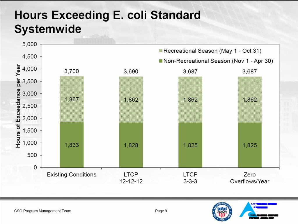
7 Water Quality Attainment Not In Attainment for Biological and Recreational Use Standards. Reasons: CSOs, Habitat Loss, Polluted Runoff, Legacy Pollution, Dams, Dredging, Organic Enrichment Signs of Improvement!
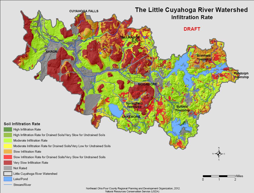
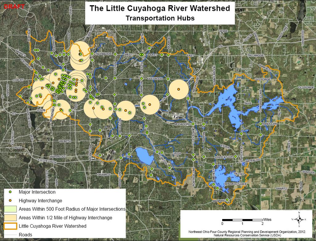
8 Little Cuyahoga River Watershed Mapping 15 Maps to Be Used to Develop a Balanced Growth Plan
9
10
11

12
13
14
15
16

17

18
19

20

21

22
23
24 Volunteer Monitoring Sierra Club Portage Trails Group Surface Water Monitoring Part of a Statewide Effort Equipment Funded by Aveda Quarterly 36 Locations Locations Mirror Ohio EPA Sample Locations with Additional Sites Added Working with Ohio EPA on Creditable Data Certification

25
26 Volunteer Monitoring Data Collected Visual Assessments Temperature TDS Conductivity Salinity Total Hardness Total Chlorine Free Chlorine Total Alkalinity ph Nitrate Nitrite Phosphate Observations Future Meeting Topic
27 Balanced Growth Planning Voluntary, incentive based strategy Goal: Long-term Economic Competitiveness, Ecological Health, and Quality of Life Reducing Urban Sprawl Protecting Natural Resources Encouraging Redevelopment Watershed Planning Partnerships FUNDING INCENTIVES for Endorsed Plans
28 Balanced Growth Planning Priority Conservation Areas (PCAs( PCAs) Locally Designated Areas for Protection and Restoration No Change in the Owner s Property Rights Property is Still Subject to Local Land-Use Regulations. State Policy Decisions would Recognize the Property as a Conservation Area State Would NOT Encourage or Provide Funding for Development of the Area
29 Balanced Growth Planning Priority Development Areas (PDAs( PDAs) Locally Designated Areas for Growth and/or Redevelopment Maximize Development Potential Efficient Use of Infrastructure Promote Revitalization of Existing Cities and Towns Contribute to the Restoration of Ohio s Waters Land May Be Eligible for State Policy and Funding Incentives Not Like and Urban Growth Boundary Development Can Occur Outside of the PDA, But Would NOT Be Encouraged Through State Investments
30 Community Survey The Watershed Community Determines what is Important in the Watershed Survey is to Assist NEFCO in Determining these Priorities What Are the Conservation and Development Priorities? NEFCO will Map Results for Use in Determining PCAs and PCDs
31 Community Survey Conservation Priorities? Open Space, Riparian Areas, Wetlands, Stream Bank Erosion, Stream Restoration, Floodplains, Recreation, Storm Water Runoff, Etc. Development Priorities? Brownfields,, Public Water/Sewer, Population Density, Highway Interchanges, Recreation, Reduced Flood Hazards, Land Availability, Redevelopment, etc.
32 Community Survey Survey Review Reviewed by the Stakeholder Group before distribution Distribution Internet Meetings How Large of a Sample Size
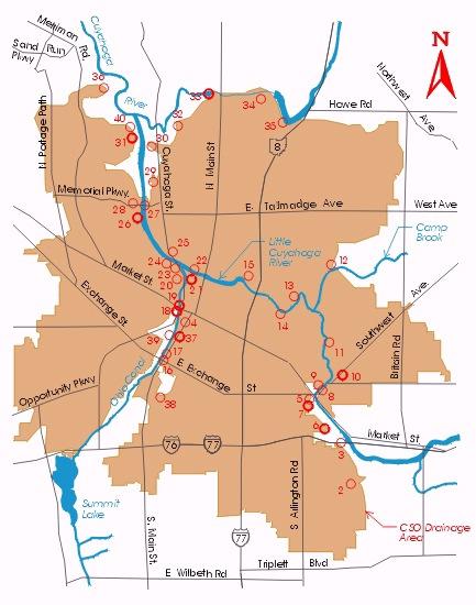
33 Combine Sewer Overflow Introduces nutrients, bacteria, and pathogens into the Little Cuyahoga 29 CSOs in the Little Cuyahoga River Watershed Long Term Control Plan Implemented Over the Next 15 Years Approved by Key Stakeholders Judge Adams Reviewing 0 Untreated Overflows During a Normal Year
34 CSO Control Measures 10 Wet Weather Storage Basins Sewer Separation Projects 2 Large Diameter Underground Storage Tunnels Improvements to the Wastewater Treatment Plant Interceptor Relief Sewer Sewer Inspection and Cleaning Mud Run Pump Station Over $800 Million Price Tag
35
36

37 Group Discussion Eric Akin