Stinson Beach Watershed Program
|
|
|
- Tyler Cameron
- 5 years ago
- Views:
Transcription

1 Stinson Beach Watershed Program Purpose The Board of Supervisors authorized the Department of Public Works to begin implementation of a County-wide Watershed Program on May 13, The purpose of the County-wide Watershed Program is to provide a framework to integrate flood protection and environmental restoration with public and private partners to protect and enhance Marin County s watersheds. A watershed program was recommended for Stinson Beach to develop a suite of integrated projects that address on-going flooding and sedimentation issues in the lower sections of the creek while maintaining and improving habitat for steelhead trout and Coho salmon. Background Easkoot Creek drains an area of approximately 1.59 square miles of mostly undeveloped and steeply forested watershed on the side of Mt. Tam. Early maps depicting the proposed subdivision development in the 1900s show the creek channel close to its present alignment until just downstream of the sharp turn at Arenal Avenue. The historic channel then branches off as the channel slope loses its grade and enters a willow thicket (on the current Park Service land). Early maps show an alternative alignment for Easkoot Creek breaching the sand dunes. With the development of Stinson Beach and the public park, Easkoot Creek has been maintained in its current alignment to Bolinas Lagoon. There are three sources of flooding in Stinson Beach: overflow of Easkoot Creek, extremely high tides, and extremely high surf. Each of these alone can cause some flooding and when combined, can cause substantial flooding, property damage and public safety problems. The Arroyo and Calle area of Stinson beach are flooded annually during extreme high tide events.
2 Initially, when Flood Control Zone 5 was established one of the primary maintenance tasks performed was periodic dredging of the creek. Over time it has become evident that during medium to large storm events an active slide on Mt. Tam releases enough hillside material to fill in the creek, even if it has recently been dredged. The essentially flat reach from Arenal to Bolinas Lagoon creates a slower moving creek and a natural area for sediment to settle and deposit. The excessive sediment build-up within this reach of Easkoot Creek has significantly reduced the level of flood protection through the Calle area of Stinson Beach. The private bridges along the residential streets known collectively as the Calles have limited to no clearance from the creek during storms, which may contribute to the flooding of neighboring homes and preclude access to and from Shoreline Highway. These bridges are a hydraulic constraint, but they are the primary access to homes and the primary access for emergency vehicles. The County and Flood Control Zone 5 has spent significant funds to perform limited dredging at the Calle bridges that is typically effective for only one to two seasons and requires dewatering the channel and relocating Steelhead trout to minimize impacts. As a condition of the sediment removal permit, the regulatory agencies have required that we investigate alternatives to the dewatering and the spot dredging approach since the creek has an established run of Steelhead. Staff are working with the National Park Service to explore the feasibility of constructing an interim sediment basin on Park Service property downstream of Arenal Avenue to capture sediment in one location instead of multiple locations downstream thus reducing impacts to Steelhead and other aquatic life Stakeholders working through the Technical Work Group have identified issues and alternatives that were included in the development of the watershed study request for proposals. The County solicited proposals and in October 2011 and awarded a contract to O Connor Environmental Inc. (OEI) to conduct a hydrology and hydraulics (H&H) study and alternatives analysis to meet a suite of project goals. This study will focus on riverine flooding and also includes the identification of alternatives that would reduce ongoing maintenance costs and impacts from channel dredging while promoting alternatives that would enhance habitat and improve resiliency to sea level rise. Project Goals A process to evaluate and prioritize feasible flood protection projects at the watershed scale Assessment of wetland and floodplain restoration opportunities along Easkoot Creek Identify integrated flood management and habitat restoration projects Identify opportunities to leverage local funding with State and Federal funds Evaluate flows utilizing projected rise in sea level within Bolinas Lagoon Stakeholder and Community Outreach The watershed program utilizes a collaborative, iterative process to develop integrated solutions to flood protection and habitat restoration. The Marin County Board of Supervisors recommended establishing stakeholder committees at three levels to support community outreach and to provide overall program direction (a complete list of committee members is attached at end of this document). A broad community outreach program is also recommended.
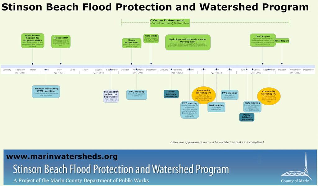
3 Description of Watershed Stakeholder Committees Policy Advisory Committee - This group of elected officials is comprised of the District County Supervisor and two representatives from the Flood Control Zone 5 Advisory Board. This committee provides policy input on program direction and community issues and will meet 1-2 times per year. Operations and Finance Committee- The Marin County Public Works director will use these meetings with Flood Control staff to evaluate progress and prioritize funding strategies and will meet 1-2 times per year. Technical Work Group- This group includes staff of participating State, Federal and local regulatory and participating agencies and community members with a science and technical background who will be responsible for the review of watershed products and provide input on issues, needs and watershed priorities. This group will include conservation and watershed groups, homeowners associations and other technical experts within their respective watersheds. This group has met five times over the last year to scope the RPF and to provide input and to review the development of work products Community Outreach Targeted community meetings, presentations at various local boards and homeowners associations and utilization of the watershed program website ( will support communication to the community at large. The program website provides dedicated information about the watershed and is regularly updated with meeting notices, proposals and projects. Program Description and Outcomes The watershed program will build upon existing studies and develop new analytical tools to evaluate and quantify the extent of flooding and to evaluate the range of proposed solutions. The study and tools developed will provide staff and the community with an understanding of existing conditions as well as understanding how various alternatives could reduce flood damage and restore creek habitat. The following is a description of the proposed tools and outcomes. An overview of existing conditions and relevant studies is available at Schedule 2011 November: Consultant begins work on the Stinson Beach Watershed H&H Study Technical Working Group meeting #4 to introduce the consultant team December Field surveys 2012 January: Consultant team reviewing data to produce hydrology and hydraulics model. February: Policy Advisory Committee meeting March: Technical Working Group meeting to prepare for Community Meeting and discuss criteria development April: Community Meeting to present overview of existing conditions and the H&H model Hydrology and hydraulics study: The hydrology and hydraulics study will perform the following main tasks: Quantify and communicate the existing creek and floodplain conditions in Easkoot Creek.
4 Develop a watershed hydrology model to identify a set of flood flows including limited geomorphic work to improve understanding of sediment transport and deposition and to assess the rate of sediment deposition. Develop a hydraulics model of Easkoot Creek and model conceptual project alternatives for their benefits (including evaluation of sea-level rise scenarios) with input from our stakeholders A coastal geomorphologist (John Largier-part of the OEI team) will evaluate the potential issues involving a direct ocean connection for the creek. In particular, potential outlet stability issues and the implications of summer closure of the bypass channel will be evaluated with respect to impacts to water quality, fisheries, flooding, and facilities at Stinson Beach. Evaluation of Coastal Flooding and Erosion While the primary focus of this program is to identify projects to protect the community from riverine flooding, Stinson is also impacted by coastal flooding and erosion. Direct coastal flooding is currently being studied by the USGS/NOAA under the Our Coast, Our Future project. Once the riverine flood studies are complete, County staff will work with USGS and NOAA staff to evaluate the combined risk from coastal and riverine flooding and to evaluate alternatives that address impacts from both types of flooding. Alternatives analysis Develop preliminary (appraisal-level) designs for potential flood mitigation solutions that are protective of creek habitat and integrated at a watershed level. At a minimum, details for each evaluated project should include: Description, including associated facilities, their proposed function, operational and maintenance requirements, and short- and long-term sustainability General location, dimensions, and extents, with elevations of key components where appropriate (e.g., weir(s), detention pond) Approximate construction, operation, and maintenance costs Assessment of current vegetation and sediment removal maintenance methods A list of assumptions and the type of data used to establish these for design development Schedule 2012 (continued) July: Technical Working Group meeting #5 to continue development of alternatives. Policy Advisory Committee meeting August: Technical Working Group meeting #7 to prepare for Community Meeting September: Report from consultant Community Meeting #2 to present study results (including alternatives) and to discuss next steps October: Final Report from consultant 2013/14 NOAA and FEMA coastal mapping to be released Final report This process and study results will be summarized in a final report. The final report will also include recommendations for leveraging local
5 funds to secure State and Federal grant funds and describe the type of local revenue measures that could support project implementation. Program Budget Expenditures Easkoot Creek Hydrology and Alternative Process $120,000 Coastal Flooding mapping and assessment $65,000 Project Management $60,000 Staff Plate and Streamflow Monitoring $5,000 GIS and Habitat Mapping $25,000 Outreach $30,000 Financial Strategy $25,000 Total $330,000 Revenue County of Marin $300,000 Flood Zone No. 5 $30,000 Total: $330,000 Stakeholder committee roster Policy Advisory Committee (PAC) Supervisor Steve Kinsey Flood Zone 5 Advisory Board: John Washington and Howard Schecter Operations and Finance Committee Craig Tackabery, Assistant Director of Public Works, County of Marin Tracy Clay, Flood Control Division Manager Technical Working Group Golden Gate National Recreation Area (National Park Service): Darren Fong and Daphne Hatch State Parks: Bree Hardcastle and Victor Bjelajac Flood Zone No. 5: Howard Schecter and John Washington Marin County Flood Control District: Pat Balderama County of Marin Community Development Agency: Tom Lai Stinson Beach Water District: Ed Schmidt Marin County Open Space District: Mischon Martin and James Raives Stinson Beach Fire: Kenny Stevens Homeowners Associations: Terry Houlihan (Seadrift), Scott Tye (Stinson Beach Village Association), and Barbara Williams (Calles) State and Federal Resource Agencies (as needed) NOAA Fisheries: Rick Rogers, Fish and Game, Regional Board, Army Corps of Engineers tbd
6 Watershed staffing Chris Choo, Senior Planner Project Manager, manage contracts and track consultant budget. Coordinate public outreach efforts including meetings with Technical Working Group, Flood Advisory Board and community meetings. Roger Leventhal, P.E., Associate Engineer Review consultant products and provide engineering and hydrology support. Laurie Williams, Senior Planner Develop and maintain GIS database to support project planning. Prepare maps for website and stakeholder meetings. Liz Lewis, Principal Planner Manage overall schedule, deliverables, and budget and coordinate communication with partners and County Departments
7