Presented by: Donald L. Ware, P.E. Chief Operating Officer Pennichuck Corporation
|
|
|
- Julie Daniel
- 5 years ago
- Views:
Transcription

1 Presented by: Donald L. Ware, P.E. Chief Operating Officer Pennichuck Corporation
2 Overview I. Watersheds and the Hydrologic Cycle II. The Pennichuck Watershed Where We Have Been III. The Pennichuck Watershed Where We Are Going 2

3 What is a Watershed? Area of land that contributes run-off water to a drainage course or water body Defined by highpoints and ridgelines What we do on the land affects water quality and quantity Source: 3
4 Changes to the Landscape can have dramatic impacts on: Water Quality due to: Increased Sediment loads created by stream bed erosion Increased Phosphorous levels from lawns, roofs, leach fields and pavement Increased Nitrogen levels from farming, lawn care, leach fields Increased levels of Volatile Organic Chemicals from parking lots Increased water temperature from parking lots and roofs Water Quantity Increased levels of storm water Decreased levels of base groundwater flows 4
5 Pre-development - Before Evapotranspiration Minimal Runoff Cool, Clean Baseflow 5
6 Reduced Evapotranspiration Post-development - After Warm Water Pollution Increased Runoff Reduced Recharge Increased Channel Erosion Infill and Eutrophication of Waters from Polluted Storm water Runoff 6

7 Clean cool base flow Minimal storm water (surface) runoff Impervious area increases storm water runoff & reduces base flow Runoff picks up pollution nutrients, sediments, oil & grease 7
8 Maintaining a Sustainable Water Supply Maintain health of ponds Reduce pollutant loads Treat storm water before it enters Pennichuck Brook Reduce infill from sediments Reduce peak storm water flows via on site detention Promote groundwater recharge and base flows Induce onsite infiltration Slow down rate of eutrophication within the ponds Remove Phosphorous from storm water Promote Ordinances that result in Low Impact Development 8
9 II. The Pennichuck Watershed Where We Have Been 9
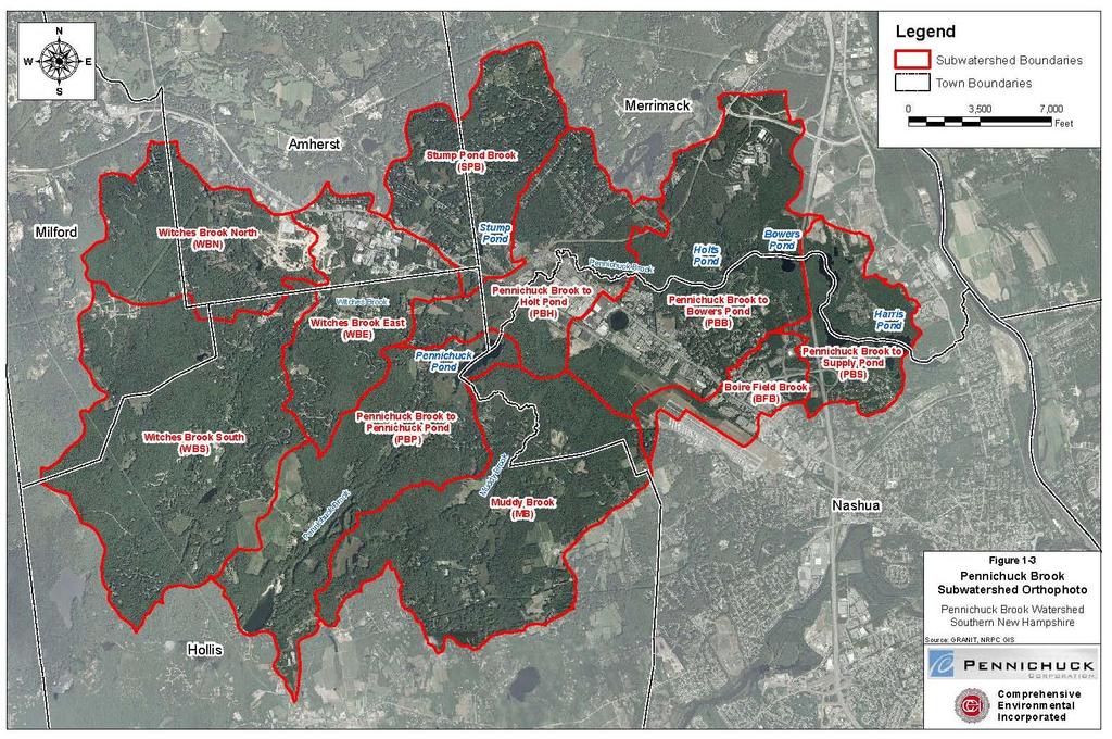
10 Background 17,000 acre urbanizing/urbanized watershed to outlet of Harris Pond Occupies land in five towns Nashua, Merrimack, Amherst, Milford, Hollis 10 subwatersheds of roughly 1,200-3,200 acres each 10
11 11
")
12 Past Efforts (1998-Present) 12
13 Efforts to Date Studies 1998 Watershed Study Subwatershed Studies Pond Sediment Study 2008 Watershed Restoration Plan Public Education/Zoning City Watershed Protection Ordinance Catch Basin Marking Program Community Based Social Marketing (CBSM) Public Works/Planning Staff Seminars Watershed Website 13
14 Projects Efforts to Date (Cont.) Nashua Community College Stormwater treatment system Pennichuck Square Demo Retro site Celina Ave and Cornerstone Storm Water Best Management Practices (BMP s) Tinker Road Detention Basin Retrofit Harris Pond Aeration Long-Term Monitoring Program 14
15 Water Quality What We Know 15
16 Water Quality What We Know 16
17 Water Quality What We Know Water quality appears to be improving but data is limited More data is needed to better define the health of the ponds and watershed and direct future watershed clean up efforts Goals are: Reduction in phosphorous and nitrate levels Reduction in sediment inputs into the pond Rebuild base groundwater flows 17
18 III. The Pennichuck Watershed Where We Are Going 18
19 Watershed Restoration Plan 2008 Plan updated this year Goal Remove over 2000# of Phosphorous (PO 4 ) input into the ponds per year Identifies biggest bang for buck Public education 285# of PO 4 per year Develop Storm water program for schools Lawn Maintenance practices Website Regulations - Encourage Local Adoption of State Alteration of Terrain regulations 936# of PO 4 per year Private property maintenance (very expensive, hard to implement) Parking Lot Sweeping 96# of PO 4 per year Catch Basin Cleaning 135# of PO 4 per year Installation of Storm Water BMP s at top 10 sites - 231# of PO 4 per year 19

20 Top 10 Storm Water BMP s 20
21 Recommended Approach to Water Supply Protection Continue monitoring over next 3-4 years to obtain enough information to assess health of ponds. Initiate Groundwater monitoring. Focus on public education and local adoption of State regulations during this time. Update restoration plan model at end of 3-4 year period and re-evaluate restoration approach. 21
22 Questions?? 22