Regulatory Programs Administered by Indiana DNR, Division of Water presented by George Bowman
|
|
|
- Eileen Wilkins
- 5 years ago
- Views:
Transcription

1 Regulatory Programs Administered by Indiana DNR, Division of Water presented by George Bowman
2 Presentation Overview Division of Water s role in DNR Regulatory Statutes and Rules Floodplain, Floodway, and Flood Fringe Public Freshwater Lakes / USACE PGP / Ditch Act Navigable Waterways and Lake Michigan Submittal Information / Minimum Technical Requirements / Examples Environmental Assessment Exemptions and General Licenses Questions Supplemental Information on Application Form, Fees, and Public Notice
3 Division of Water We strive to alleviate flood disaster damages and abuse of Indiana's water resources by administering the construction permitting and compliance programs determining floodplain information conducting dam and levee inspection initiating construction projects administering water rights program generating surface and groundwater studies cooperating with other IDNR Divisions and other governmental agencies to accomplish our common goals, and providing public education
4 Permitting Statutes and Rules Flood Control Act, IC & Floodplain Management Rules, 312 IAC 10 Lake Preservation Act, IC & Public Freshwater Lake Rules, 312 IAC 11 Navigable Waterway Act, IC (includes Lake Michigan) & Navigable Waters Rules 312 IAC 6 Lowering of the Ten Acre Lake Act, IC Not covered in this presentation: Sand and Gravel Permits Act IC Construction of Channels Act, IC
 square mile Floodway is the channel and land surface area necessary to discharge the regulatory flood Regulatory floodplain is determined statistically as having a 1% chance of a flood event of")
5 DNR Flood Jurisdiction Control Act Regulatory Flood Construction that proposes development, placing fill, or excavating materials in the floodway On waterways having a drainage area of at least one (1) square mile Floodway is the channel and land surface area necessary to discharge the regulatory flood Regulatory floodplain is determined statistically as having a 1% chance of a flood event of that magnitude occurring in any given year Note: Every waterway has a floodplain and a floodway; but many are not identified on floodplain maps

6 Floodplain = Floodway + Flood Fringe 1% annual chance _
7 A project in the floodway may NOT Adversely affect the efficiency or capacity of the floodway (an increase in the regulatory flood elevation of at least 0.15 feet / cannot back up floodwaters more than 0.14 beyond the project s property) Present an unreasonable hazard to the safety of life or property (resulting from the increase as noted above) Result in unreasonably detrimental effects upon fish, wildlife, or botanical resources (based upon the opinion of a professional qualified to assess the damage and (1) creates a condition where recovery of the affected resources is not likely to occur within an acceptable period; and (2) cannot be mitigated through the implementation of a mitigation plan approved by the director) Assessment of the above criteria includes the cumulative impacts from other projects in the vicinity

8 Lake Preservation Act The project will be reviewed on the basis of its impacts on: the shoreline, water line, or bed of the public freshwater lake, the fish, wildlife, or botanical resources, the public rights for the natural resources, the natural scenic beauty, and the recreational purpose of the lake, the management of watercraft operations the interests of a landowner having property or access rights assessment of the above criteria includes the cumulative impacts from other projects in the vicinity In addition, any construction, reconstruction, recleaning; or repair of a ditch, dam, or other project that is likely to affect a lowering of the water level of the public freshwater lake, that covers an area of at least ten (10) acres, regulated or otherwise, is prohibited.

9 Lake Preservation Act jurisdiction Projects that are proposed lakeward, along the shoreline, or walls landward of the shoreline within 10 feet and below the legal or normal water level of a public freshwater lake require a permit Green scenario= outside jurisdiction of Lake Preservation Act Red X = requires a permit under Lake Preservation Act X X X List of Public Freshwater Lakes can be found at
10 USACE PGP (Programmatic General Permit) The PGP applies only to certain types of construction activity on public freshwater lakes regulated under the Lake Preservation Act. Announcement Notice under Featured Topics at One-stop-shopping concept Only one application form is required to be completed and submitted to DNR for reviews under IC , Section 401 and Section 404 Under the PGP, if a proposed construction project qualifies under the PGP Category 1, the Certificate of Approval issued by IDNR will also qualify the project for the authorization under the Section 404 of the Clean Waters Act regulated by the U.S. Army Corps of Engineers and the Section 401 Water Quality Certification regulated by the Indiana Department of Environmental Management. This Section 404 and Section 401 authorization is subject to complying with the federal general conditions provided with the IDNR Certificate of Approval If the project does not meet the PGP Category 1 criteria, IDNR will forward a copy of the application to the USACE district office for review of the project under the federal regulations. IDNR will notify the applicant and agent with a letter to inform them that a copy of the application has been mailed to the USACE for review
11 PGP Eligibility in Summary Eligible Category 1 activities Prior authorization from DNR or qualifies for General License activity under 312 IAC New seawalls constructed of bioengineered material or glacial stone and no more than 250 in length Refacing of existing seawalls of like material Beach construction as noted under 312 IAC Fill of existing boatwells; no more than 20 wide x 30 long Not located along a shoreline classification of a Significant Wetland or of Natural Shoreline Eligible Category 2 activities Construction activity > 250 and < 500 in length (> 500 in length requires Individual Permit) New concrete or sheet piling seawalls Beach construction other than those identified in Category 1 Activity located along a shoreline classification of a Significant Wetland or a Natural Shoreline Activity in USACE jurisdiction but not in DNR jurisdiction For additional information about the Programmatic General Permit, contact the U.S. Army Corps of Engineers office at , Detroit District Office or , Louisville District Office, or refer to the public notice available at
12 Lowering of the Ten Acre Lakes Act, a.k.a. Ditch Act Projects on ditches or drains within one-half (1/2) mile of a freshwater lake, ten acres or greater in size, where the construction performed will occur at a bottom depth lower than the legal or normal water level of the lake. The project may not: Endanger the legally established water level of the lake, or Endanger the normal water level of the lake, if the water level has not been legally established, Result in unreasonably detrimental effects upon fish, wildlife, or botanical resources, Assessment of the above criteria includes the cumulative impacts from other projects in the vicinity
13 Navigable Waterways Act The Roster of Navigable Waterway can be found at Includes Lake Michigan, see A project below the Ordinary Highwater Mark (OHM) of a navigable water may NOT (1) place, fill, or erect a permanent structure in; (2) remove water from; or (3) remove material from; without a permit from the department. A project in a navigable waterway may NOT Unreasonably impair the navigability of the waterway. Cause significant harm to the environment Pose an unreasonable hazard to life or property.
14 Ordinary Highwater Mark (OHM) The line on the bank made by water fluctuation and shown by physical characteristics A clear and natural line on the bank Shelving Changes in soil character Destruction of terrestrial vegetation Presence of litter or debris For OHM on Lake Michigan, see
15 Lake Michigan projects In addition to the Navigable Waterways Act criteria, a project in Lake Michigan will be reviewed on the basis of its impacts on: the likely impact of a permanent structure on coastal dynamics, including the following: Shoreline erosion and accretion. Sand movement within the lake. The interaction with existing structures. The applicant must demonstrate either that it is the fee owner of land immediately adjacent to the site where the construction would take place or that the applicant has written authorization from the fee owner of that land.
16 Application Submittal Information Permit application paper form or file with e-application at Permit Type (Construction in a Floodway, Lakes Preservation Act, etc.) Application Fee Statement of Affirmation (signed and dated application) Applicant, Agent, Property Owner Information Clear Narrative summary of Project Description Project Location Narrative, Driving Directions, Project Location Map Disturbed Area Drawing Photos and Orientation Map Related Information, e.g. other federal, state, or local permit or correspondence file number General Minimum Requirements and Detailed Technical Documentation, e.g. project blueprints or plan drawings Hydrologic / Hydraulic Modeling (when required, see *Public Notice served and proof of service submitted after application is received by the Division of Water See additional information on Public Notice requirements at Noted in red: Typical deficiencies delays processing of application
17 General Minimum Requirements & Detailed Technical Documentation Plans Showing Streams / other water features Floodplain / Floodway, if known Reference points / roads (including railroads) Existing conditions / structures / contours (buildings, parking lots, etc) Proposed construction / structures / fill / contours Dimensions, height/length/width, quantity, volume Excavation disposal site Cross sections, if applicable Property Limits North Arrow, Scale (numerical / graphical), Horizontal / Vertical Benchmarks, Horizontal / Vertical Datums Contours including date of photography, if applicable Preparer's Name and Date

18 Plan View / Disturbed Area example
19 Bank Stabilization Minimum Requirements (example)
20 Fill Minimum Requirements (example)
21 Cross Section example
22 Dredging Minimum Requirements (example)

23 Shoreline Rehabilitation Plan View example
24 Cross Section example

25 Channel Relocation example

26 Cross Section example

27 Cross Section example
28 Shoreline Stabilization Plan View example
29 Cross Section example
30 Cross Section example
31 Environmental Review in Summary Division of Fish and Wildlife Environmental Unit and field biologists Assess impacts to fish, wildlife, and botanical resources Look for avoidance; minimize disturbance; mitigation Northern Indiana Salmonid streams found; Listing of salmonid streams can be found at Recommends requesting an pre-application review on complex projects Division of Nature Preserves Maintains Heritage Database (maintains records of endangered/threatened species, DNR properties, outstanding waterways, etc.) Coastal Zone Management Program Division of Outdoor Recreation Division of Law Enforcement Assesses impacts to boating safety Division of Historic Preservation and Archeology Preserves and protects archeological sites and human remains and cemeteries
32 Exemptions and General Licenses Flood Control Act and Floodplain Management Rules General License under 312 IAC 10-5 Utility Line Crossings; with no notification Wetland Restoration; with notification & review Outfall Structures; with no notification Exemptions under IC Removal of a logjam or mass of wood debris with criteria (NEW) Reconstruction or maintenance project on a stream or an open regulated drain if the total length of the stream or open drain is not more than ten (10) miles (applies to County Drainage Broad projects as defined in IC ) A construction or reconstruction project on a state or county highway bridge in a rural area that crosses a stream having an upstream drainage area of not more than fifty (50) square miles Addition to a residential structure if cumulatively does not increase the market value more than 50% Residential structure reconstruction or improvements if cumulatively does not increase the market value more than 50% Surface coal mining operation that is operated under a permit issued under IC described in subsection (c)(1) or (c)(2) with criteria
33 Exemptions and General Licenses cont. Lakes Preservation Act and Public Freshwater Lake Rules Qualified piers, glacial stone refaces, dry hydrants and aerators with conditions 312 IAC 11-3, with criteria Certain construction activity in Lake Shafer, Lake Freeman, and water supply reservoirs IC & IC Lowering of the Ten Acre Lake Act, Ditch Act Construction on a ditch/drain inlet to lake Navigable Waterways Act and Navigable Waterway Rules Creek Rock Removal 312 IAC Recreational Prospecting in a navigable waterway 312 IAC Beach Nourishment to Lake Michigan 312 IAC 6-6 with notification Qualified piers 312 IAC 6-4-5
34 Permit Application Process Application Received Logged in Database Project Description & Location Staff Reviews: Technical /Engineering Fish & Wildlife Outdoor Recreation Nature Preserves Inspection USACE PGP Groundwater Review Typical processing time 60 + days from receipt of complete application submittal Department Action Public Notice Request Reviews of: If Navigable Archaeology Law Enforcement Hearing (if appealed) Public Hearing (if requested)

35 All rules, statutes, and application manual can be found at:


36 How to contact us Website: Inquiries: Toll-free Number: or Ext. 1: Technical Services Section provides daily assistance and guidance on regulatory and floodplain information Steve Davis, Lake Michigan Specialist,
37 Questions??
38 Application Form, Fees, and Public Notice Requirements The following slides are additional information for your reference (not covered in presentation due to time limitation)

39 Online Application
40 Application Fees Depending on the type of projects the application fees can vary Application Fee Code Title Fee IC Lake Preservation Act $ 100 IC Lowering of Ten Acre Lakes Act $ 25 IC Flood Control Act - choose one of the following All non-residential floodway construction projects $200 Residential reconstruction in a floodway, other than the Ohio River floodway $ 50 Residential construction, or reconstruction, in the Ohio River floodway $ 10 IC Navigable Waterways Act No fee IC Sand and Gravel Permits Act $ 50 IC Construction of Channels Act $100
41 Public Notice Requirments Both the applicant and the Department of Natural Resources must provide public notice Applicant Public Notice: Public notice must be sent after the application is received by the Department It is required that the Department wait 30 days after the applicant s public notice and the Department s public notice is served before issuing a permit; therefore, it is beneficial for the applicant to send public notice as soon as possible after the Department receives the application
42 Public Notice Form # You can obtain this form online at
43 Adjacent Property Owners Form #52086 Form requires applicant to list individuals Names Addresses Dates of service Form can be obtained online for from the Department at:
44 Applicant Public Notice Must notify at least one of the owners of each parcel of real property reasonably known to be adjacent to the affected real property Adjacent to the affected real property means real property owned by a person other than the applicant, which is both of the following Located within one-fourth mile of the site where the activity would take place AND Has a border or point in common with the exterior boundary of the site where the activity would take place

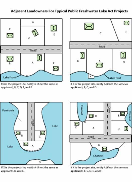
45 Example of Adjacent Properties
46 Proof of public notice Three methods that Public Notice can be provided: Personal Service 1 st Class Mail Certified Mail Newspaper publication is only used as a last resort