Little River Watershed Restoration Project. Mark Powell, Consultant Natural Resources Management
|
|
|
- Cora Gibbs
- 5 years ago
- Views:
Transcription


1 Little River Watershed Restoration Project Mark Powell, Consultant Natural Resources Management
2 Lessons Learned Strong partnerships RC&D, Soil and Water, 2 counties, Albemarle Commission, Universities, local groups Good communication with county managers and local and state government representatives Good connections and communication with local farmers BMPs part of whole farm management Persistence pays off!

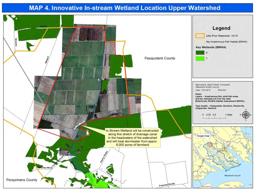
3 Little River Watershed HUC 10 NC VA

4 86,000 acres

5 Upper River

6 Middle River at US 17

7 Lower River South of US 17 Albemarle Sound
8 Impairments 1998 the upper section of the river from its source to Halls Creek (12 mi.) on the 303(d) list of Impaired waters for low Dissolved Oxygen. In 2012 and 2014, an 8-mile section of the Little River from SR 1225 to Halls Creek was listed Impaired for Chlorophyll a indicating nutrient enrichment in this segment of the river.

9 8 Mile Impaired Section of River
10 Little River Watershed Nine-element restoration plan completed early ,300 acres of Strategic Habitat Area. 2,500 acres and 17,000 acres of Exceptional and Substantial wetlands, respectively. 7.5 square miles of Critical anadromous fish spawning areas. 540 acres Submerged Aquatic Vegetation along the Albemarle Sound Nine animal, plant and natural communities identified by the NC Natural Heritage Program.


11 Impairments Agricultural operations have opened drainage canals that directly carry sediments and nutrients to the river, and residential and commercial developments have increased pollution from stormwater runoff.

12 Impairments Riparian forest buffers have been eliminated or severely degraded in many locations along the river.
13 9-Element Restoration Plan Construct in-stream wetlands on main drainage canals Work with counties and landowners to conserve and/or restore riparian forest buffers
14 CWMT USFWS EPA 319 Albemarle RC&D Council
15 Approx 6 acres of in-stream wetlands $141,878 CWMTF $25,000 USFWS
16

17 Wetland constructed along 2,600 of main drainage canal
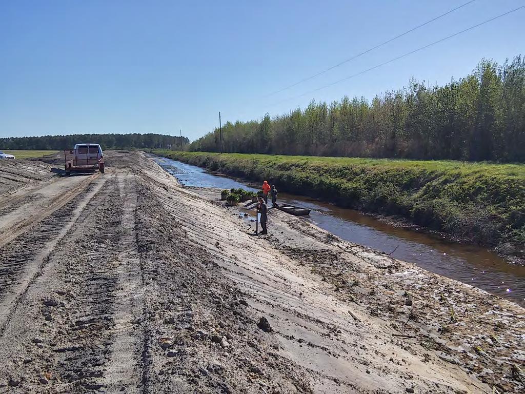
18
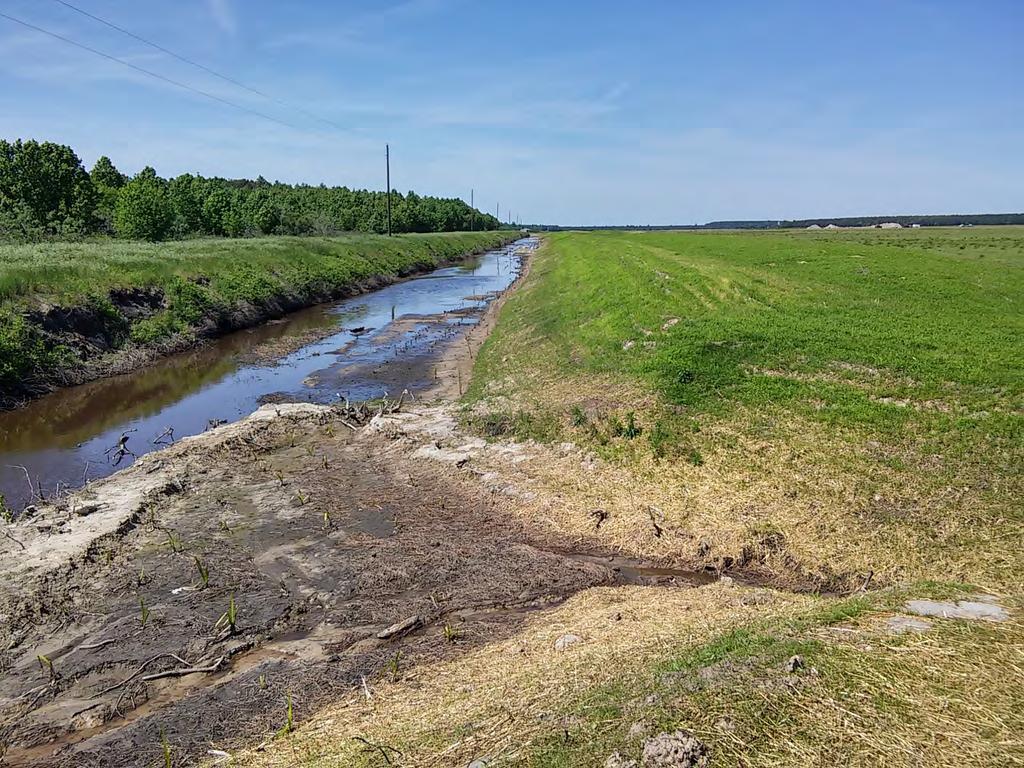
19

20 Water re-directed to head of wetland

21 4 acres of cypress inter-planted

22 Impaired Section
23 EPA 319 Grant - Boyce Tract Outlet to Little River Albemarle RC&D Council

24 Rock weirs to stage water J-hooks to slow water flow Outlet to Little River Rock drop structures

25 Rock weirs to stage water EPA 319 Grant - Boyce Tract J-hooks to slow water flow Outlet to Little River Rock drop structures


26 Seven Drop Structures 3 tile lines for cropland water management

27 CWMTF EPA 319 Albemarle RC&D Council
28 Riparian Forest Conservation Worked with Perquimans and Pasquotank counties to develop a voluntary riparian forest conservation program Conserve 300 ft forest buffer and receive break on taxes for acreage enrolled Easy enrollment and flexible tax office manages program, GIS department determines buffer area
29 Monitoring and Evaluation M&E led by NCSU Department of Bio&Ag Engineering Compare predicted drainage and runoff from the watershed and measured wetland outflow volumes. Take water quality samples over time and at various flow stages to measure water flow, N, P and sediment. In the second year, conduct two field days for farmers and conservation professionals in eastern NC.

30 Lessons Learned Strong partnerships RC&D, Soil and Water, 2 counties, Albemarle Commission, Universities, local groups Good communication with county managers and local and state government representatives Good connections and communication with farmers BMPs part of whole farm management Persistence pays off!
31 Little River Watershed Restoration Project Mark Powell, Consultant Natural Resources Management