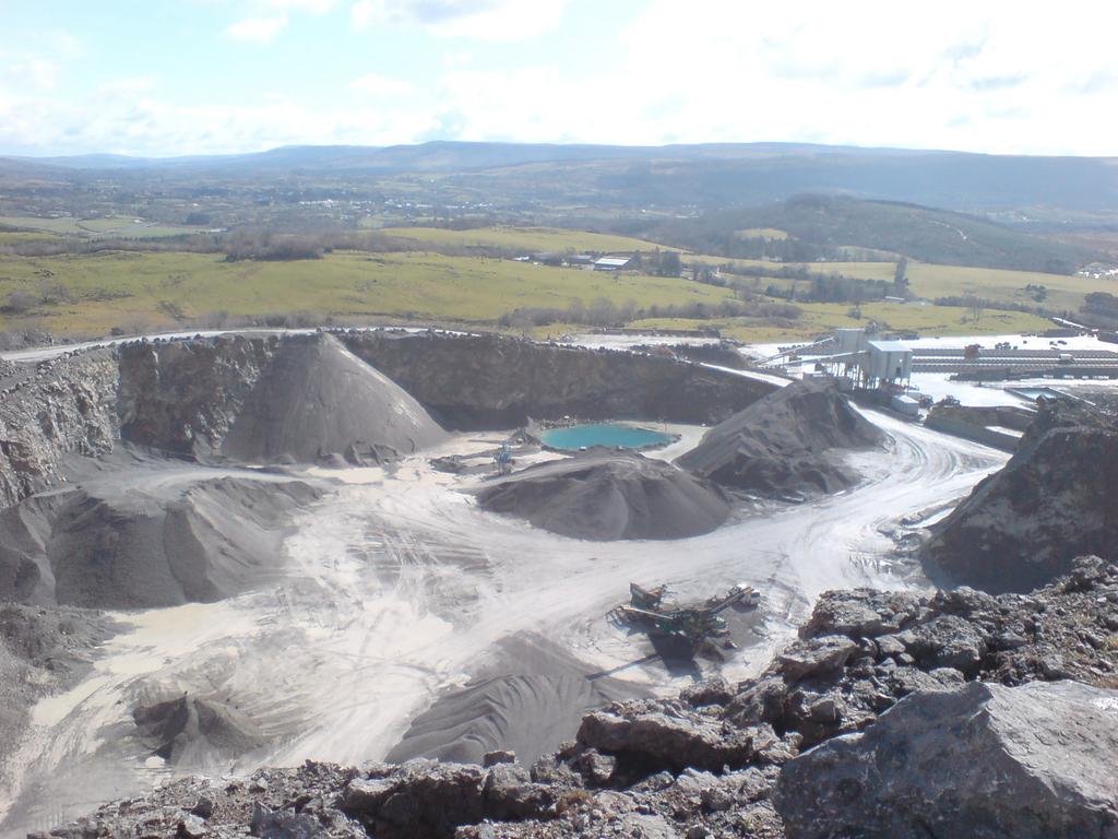
Oversized quarry sumps can be used to store run-off during
|
|
|
- Ezra French
- 5 years ago
- Views:
Transcription

1 Oversized quarry sumps can be used to store run-off during large events

2 Paved quarry yard with channels routing run-off to attenuation
3 3 The Hydrogeology of Quarry Dewatering Extraction below the water table inherantly induces drawdown local to the void and will modify the pre-existing groundwater regime. Any impacts must be quantified and if the effect is negative then it should be mitigated against. Often, it is difficult to estimate the extent of drawdown from a greenfield development. In the case of an extension to a existing quarry then historical data may be available.


4 3.1 Potential Direct Impacts Direct impact to groundwater quantity by quarry dewatering. wells springs groundwater protection zones river abstractions wetland habitats Recovery of groundwater levels post extraction

5 Direct impact to groundwater quality by contamination. Potential Direct Impacts All potential contaminents must be removed from site post extraction. Quarries operating below the water table tend to develop a trough in the groundwater surface. This acts as a hydraulic trap preventing any potential contamination from discharging into the aquifer. 3.1
6 3.2 Potential Indirect Impacts By stripping the superficial deposits and removal of the bedrock for aggregate, evapotranspiration and recharge are removed from the area of the quarry excavation. All rainfall effectively becomes run-off. The removal of recharge areas can lead to reduction in river baseflow and increase in storm flow during events. These can be mitigated against with routing and storage of runoff waters to recharge trenches.
7 The groundwater table
8 Schematic Drawdowns Associated with Strata of Different Aquifer Characteristics High T High S Low T Low S
9 Relationship between the Cone of Drawdown and the Annual Water Table Fluctuation
10 Typical Features Affecting the Cone of Drawdown Associated with Quarry Dewatering
11 Excavation Type Medium sized quarry Small sized quarry Medium sized quarry Medium sized quarry Large sized quarry Extent of Drawdown Strata Depth below w.t. Discharge Rate (l/s) Extent of drawdown (m) Condition Ballyadams Fm Limestone (Major aquifer) Steady state Siltstone / dolerite (Poor aquifer) 10 5 (winter) <50 Extended sump test Greywacke / dolerite (Poor aquifer) 25 <10 <50 Steady state Ballysteen Fm Limestone (Locally imp.) 25 < Steady state Ballysteen Fm (Major Aquifer) Steady state Comment Large fault passes through the extraction area 14 day test in winter Hillside quarry Hillside quarry
12 Hydrogeological Classification Aquifer Aquifer The principal types of potential water impact Relationship to the water table Unsaturated Zone Saturated Zone Potential impacts during extraction Major G.W. quality G.W. quantity & S.W. quality Minor S.W. quantity (if extensive) - Potential post-extraction impacts Major G.W. quality (if extensive and not reinstated properly) S.W. quantity (until rebound occurs) and G.W. quality Minor - - This table applies to unconfined conditions. S.W. = Surface Water G.W. = Groundwater. Examples in Ireland Many old limestone quarries Quarries in moderate and high permeability strata
13 Hydrogeological Classification Aquitard Aquitard The principal types of potential water impact Relationship to the water table Potential impacts during extraction Major Minor Potential post-extraction impacts Major Minor Unsaturated Zone - S.W. quantity (if extensive) - G.W. quality. S.W. quantity (If extensive) Saturated Zone S.W. quality G.W. quality - G.W. quality This table applies to unconfined conditions. S.W. = Surface Water G.W. = Groundwater. Examples in Ireland Many old rock quarries Many rock quarries in low permeability material.
14 3.2 Tools to Estimate Drawdown Extent In the case of an extension to an existing quarry drawdown can be measured from monitoring wells around the periphery of the site relative to water levels in the quarry sump. However, drilling should always be undertaken in the extension area to assess the geology. In the case of greenfield development or deepening of quarry below the water table the properties of the aquifer can be assessed by undertaking well testing, which will induce drawdown in the aquifer. Numerical modelling can also be used to assist with the prediction of drawdown and groundwater inflows.
15 Conclusions For the majority of quarries the greatest component of water managed on site and discharged to surface water is often rainfall run-off and not groundwater inflows. Both direct and indirect potential impacts should be assessed and mitigated against if negative. Often, drawdown is difficult to estimate; however, data from aquifer testing can be used to determine extent. Groundwater modelling can be used to help estimate the extent of drawdown. The quarry void forms a trough in the groundwater table. This acts as a hydraulic trap so that in the event of contamination originating within the quarry it is unlikely to disperse into the aquifer.