Monitoring Report #3 Kenston Lake Stream Restoration Bainbridge, Ohio
|
|
|
- Warren Jennings
- 5 years ago
- Views:
Transcription


 688-0111")
1 Monitoring Report #3 Kenston Lake Stream Restoration Bainbridge, Ohio Prepared by: EnviroScience, Inc Stow Rd Stow OH (330) Year Ending: December 31, 2013
2 I. Project Overview The following information summarizes the 2013 monitoring activities for the restoration of the unnamed tributary of Linton Creek located in the former lake bed of Kenston Lake in Bainbridge, Ohio. It follows the format of the USACE Regulatory Guidance Letter No dated October 10, 2008, and satisfies the requirements listed in Nationwide Permit 27 issued for restoration activities. (1) Corps Permit Application Number Permittee: Ms. Lorrie Benza Bainbridge Township Trustee Bainbridge Township Hall Chillicothe Road Bainbridge, Ohio Consultant: Joel Bingham EnviroScience, Inc., 3781 Darrow Rd, Stow, OH (330) (2) Monitoring conducted by Jeff Niehaus and Tom Ludwig Monitoring Date: 27 June 2013 and 12 July 2013 (3) The project authorized the restoration of 1,475ft of unnamed tributary to Linton Creek to pre-impoundment conditions and the stabilization of 105ft and 55ft of two tributaries totaling 1,635ft. The impacts were necessary to achieve restoration, stabilization and habitat enhancement of the remnant Kenston lake bed following drainage and outlet modification. Modifications to the outlet were necessary due to internal dam failure and increased liability with the dam to continuing to function without intervention. The outlet modifications and draining of the lake was a completely separate project. This project was primarily a floodplain/stabilization restoration project. Over 50 years of accumulated sediments impaired the historic valley and stream channel that began to recover following lake drainage. Consequently, the original morphology and floodplain was entrenched by an average 3ft of muck and stream banks were highly unstable. In the upper portion of the project area, newly formed wetlands from the staged draw-down of the dam were proposed to be impacted by a combination of sediment removal and spoil. Efforts were taken to minimize impacts to these wetlands during construction, but ultimately impacted wetlands were restored on-site to satisfy the no net loss. The earthwork grading and restoration were completed on October 11, Restored plantings were completed by November 1, The amount of wetland impacts were ac (Map 2) while the amount of restored wetlands were 0.880ac (Map 1). During the monitoring survey wetland boundaries were delineated, and total acreage has increased during each monitoring year. (4) The restoration project begins on the east side of Kenston Lake Dr at the invert of the new outlet pipe. The project extends 1,475ft to the east along the main channel. The end of the project is approximately 200ft upstream of an old fore bay earthen berm. Even though this berm was distinctly modified with the restoration it is noticeable in the existing valley as man-made earthen mound. The project area starts at approximately º N, º W and ending at approximately º N, º W. From Buffalo, take I-90W to I-271S. Take I-271 south to US 422E. Take US 422 east to OH-306/Chillicothe Rd. Take Chillicothe Rd south to Bainbridge Rd/County Rd 11. Take Bainbridge Road west to Kenston Lake Dr. Take Kentston Lake Dr one half mile to project area. Project area is located in the lake bed valley just north of Kenston Lake Dr. (5) The stream channel subgrading and floodplain excavation work commenced in mid-august 2011 and was completed in mid-october (6) Performance standards The successful completion of the project will be evaluated on stream length, habitat, bank stability, floodplain expansion, entrenchment ratios and percent vegetated coverage.
3 Thus far, the stream, floodplain, stream banks and wetlands have performed very well. Access to the floodplain is evident by deposition and flow patterns. Five separate cross sections were performed and analysis indicates a significant entrenchment ratio improvement ranging from over the pre-restoration condition. The floodplain areas have stabilized well, as evidenced by a much firmer ground observed during the monitoring survey. Additional branch layering installed on outside meanders during 2011 has held up well and continues to protect the stream banks in most areas. Overall bank stability has greatly increased compared to the prerestoration condition. In general, this was due to grading to a suitable slope for planting and erosion matting as well as brush layering. A large amount of native vegetation installed in 2011 is also doing well which is detailed further in Section III. Currently, the site has 100% vegetative coverage due to the success of the native seed as well as remnant temporary seed. It is anticipated that this will stay at 100% coverage as native vegetation continues to establish. (7) During the monitoring activities of 2013, invasive species management was conducted by applying an herbicide in select areas. At that time it was estimate that approximately 15% of the project area had presence of invasive species. Reed canary grass was the most prevalent. Bare areas as well as treatment areas (postspraying) were over seeded with native species was also conducted at this time to bolster recruitment of native wetland species and to help outcompete invasive species. (8)There are no specific recommendations for additional remedial or corrective actions at this time. Continuing monitoring is necessary as required by federal and state permits. II. Requirements The monitoring requirements are included in Table 1. Table 1.Summary of Monitoring Requirements. Monitoring Requirement Permit Document target Required Date Date Completed Representative Photographs Established photo locations Annually for 3 years June 27, 2013 Wildlife Observations N/A Annually for 3 years June 27, 2013 Cross section evaluations Min. 4 cross Annually for 3 years June 27, 2013 sections Vegetation assessment <25% invasives Five years post construction June 27, 2013 Wetland Delineation No net loss 2 nd growing season June 27, 2013


 provides a site overview and location")
4 III. Summary Data This section provides information on the current condition, photos and materials that were a result of the monitoring survey. Representative photos at fixed photo locations are presented below and correspond to the locations presented on the photo location map. Attachment A provides cross sections and longitudinal profile. Attachment B (Maps 1-3) provides a site overview and location of pertinent features and photo locations (Map 2). Photo 1. Photo 2. Photo 3. Photo 4.


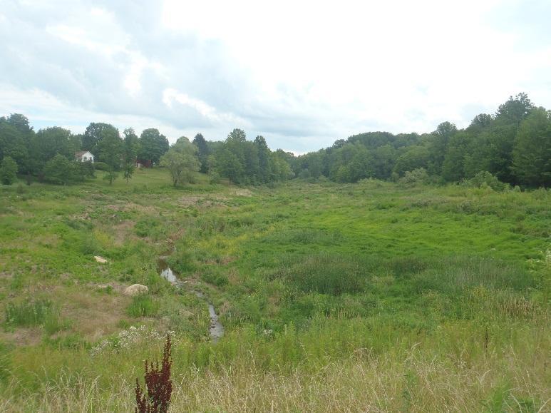

5 Photo 5. Photo 6. Photo 7. Photo 8.
6 Cross Sections 1-5 (upstream-downstream) are provided below. Locations of Cross sections are shown on Map 1 and longitudinal profile (Attachment A) Entrenchment Ratio Topo pts Bankfull pts Water surface pts Entrenchment Ratio- 3.55
7 Entrenchment Ratio Entrenchment Ratio- 2.74
8 Entrenchment Ratio Habitat The restoration project restored specific habitat for biology in relation to the stream channel and wetlands. A majority of the project reach was floodplain expansion. This morphologic improvement helps the overall habitat by reducing erosion and providing a location for deposition of fines that would otherwise embed substrates. This was due to the presence of sediment accumulation that caused a change of slope not corresponding with the overall average. In other words, it was a lump of sediment causing a gradient issue. A grade control structure and appropriate riffle-pool sequence was restored. One reach of the main stream of approximately 100ft, riffle-pool habitat was restored. Another reach of approximately 100ft immediately upstream of the new culvert was restored using imported rock, grade control and riffle-pool morphology. Similar to the upstream area, this reach had accumulated sediment upstream of the culvert where a defined channel needed to be created. Muck and unstable sediments were particularly difficult in this area. However, the restored channel has performed and has maintained its shape and function. This stream bed and banks in this area have stabilized very well. A variety of wetland habitats were restored along the stream corridor. Floodplain wetlands were associated with the lower bench of the floodplain excavation and receive regular flooding from the stream. Other wetland features were restored to accept slope drainage and groundwater seepage from the surrounding valley. These wetlands were created through spoil berms to contain water at shallow depths. All restored wetlands were planted with a variety of trees, shrubs and herbaceous plugs. Restored wetland areas totalled acre in 2011, in 2012 and now total acre as of June 2013 (Map 1).
9 Wildlife Observations Wildlife that was observed during the 2013 monitoring survey included: Fish Many unidentified fish were observed during the survey Macroinvertebrates No macroinvertebrates were observed during the survey Birds Red-tailed hawk (Buteo jamaicensis) Killdeer (Charadrius vociferus) Northern cardinal (Cardinalis cardinalis) American goldfinch (Carduelis tristis) House sparrow (Passer domesticus) Song sparrow (Melospiza melodia) Mammals No mammals were observed during the survey Reptiles / Amphibians Eastern garter snake (Thamnophis sirtalis sirta) Green frog (Lithobates clamitans melanota) Native Plantings In 2011, a total of 620 native trees and shrubs consisting of 9 species were installed into the riparian corridor. In addition, a total of 950 herbaceous wetland plugs consisting of 10 species were installed into wetland areas.
10 The following seed mix species and quantities were also installed. IV. Maps Maps are included as Attachment B. V. Conclusions Based on observations and data collected from the 2013 monitoring survey, the restoration project is performing very well. The stream has undergone some substantial rain events post construction, and the stream channel has not adjusted laterally or downcut significantly. Small amounts of bank erosion were observed in a few areas, mostly outside the areas of active construction. Water regularly inundates the floodplain and wetland areas, and retention of the wetland acreage has been successful to date. Furthermore, cross section evaluations indicate appropriate floodplain availability with entrenchment ratios ranging from Continued monitoring will provide more insight into the success of vegetation and mitigated wetlands.
11 ATTACHMENT A 2013 STREAM PROFILE Bankfull points / Average grade line Stream bed points Riffle Cross section locations Pool
12 ATTACHMENT B MAPS
13 Stream Flow KINGSWOOD DR Cross Section Locations Restored Floodplain Restored Wetland Grade Control Structure Grade Control Structures Cross Section Locations KENSTON LAKE DR
14 KINGSWOOD DR Flow Existing Wetlands Wetland Impacts acres
15 KENSTON LAKE DR 8 KINGSWOOD DR Stream Flow 3 1 2