To accomplish the above objectives, the project is comprised of four primary tasks consisting of: (1)
|
|
|
- Amberly Ellis
- 5 years ago
- Views:
Transcription
1 . Project Summary This proposal is for a single project to develop a Groundwater Sustainability Plan (GSP) for the entire Sonoma Valley Groundwater Subbasin (Basin), which is designated as medium priority basin number in California Department of Water Resources (DWR) Bulletin No The GSP will be developed through a transparent and public process based on the best available science and information so that it can be adopted by the Sonoma Valley Groundwater Sustainability Agency (GSA) and submitted to the State on or before January 31, Objectives of the proposed project include developing a GSP that: Meets requirements of the Sustainable Groundwater Management Act (SGMA) and DWR s adopted Groundwater Sustainability Plan Emergency Regulations (GSP Regulations) by establishing criteria and management actions that will achieve and maintain sustainable groundwater conditions in Sonoma Valley; Incorporates the best available scientific and technical information established through previous technical studies and voluntary groundwater management activities; Establishes a governance structure that provides opportunity for significant public and community engagement and integrates the perspectives and addresses the needs of the many diverse users and uses of groundwater resources within the Basin; Leverages the limited available funding and local resources through continued regional coordination and information sharing with other local GSAs. To accomplish the above objectives, the project is comprised of four primary tasks consisting of: (1) Formation of GSA and Establishment of Governance Structure; (2) Public Outreach/Community Engagement; (3) GSP Development; and (4) Project Management and Grant Administration. The work activities proposed in Task 3 to prepare the GSP constitute the most substantial component of the project and have been divided into seven major phases of development: (I) Prepare and Submit Initial Notification of GSP Preparation; (II) Define Plan Area and Basin Setting; (III) Develop Sustainable Management Criteria; (IV) Design Sustainability Progress Monitoring Program; (V) Identify and Evaluate Proposed Project and Management Actions; (VI) Develop GSP Implementation Program, Costs, Detailed Schedule, and Reporting (VII) Compile Complete GSP for Adoption by GSA. Development of the GSP will be a collaborative and iterative process that builds upon existing technical and policy information, including a voluntary groundwater management plan developed for the Sonoma Creek watershed in The process will incorporate input from the GSA Board, the GSA Advisory Committee, GSA Member Agencies and the public. Preparation of the GSP will have a robust public outreach component to encourage involvement and integrate input from the community. The development of the GSP will be closely coordinated with neighboring GSAs in the Santa Rosa Plain and Petaluma Valleys, as well as local agencies with land use responsibilities including the Cities of Sonoma and the County of Sonoma, as further described in Section 3.0 of this Project Justification. Basin stakeholders have a history of collaborative groundwater management and water resource planning and have made substantial commitments to complying with SGMA. In addition to technical studies and voluntary groundwater management planning activities, local stakeholders have proactively coordinated to negotiate the formation of a single GSA covering the entire Basin. The GSA has formed an Advisory Committee to reflect and solicit input from the diverse groundwater users in the Basin, which will have a key role in preparing the GSP. These foundational efforts will allow the GSA to move forward efficiently and swiftly in meeting the next required step in SGMA compliance.
2 Technical Need Groundwater resources have long played a significant role in the development, growth and sustainability of Sonoma Valley, with more than half the water demand in a given year met by local groundwater resources. These groundwater resources are relied upon by rural and urban residents, vineyards and wineries, dairies, and other businesses and also support the rich ecosystems present in Sonoma Valley. Assuring sustainable groundwater supplies in the Sonoma Valley is critical to the environmental health and economic vitality of the Basin. In recognition of the importance of local groundwater resources, local agencies and stakeholders have funded and supported technical studies and voluntary groundwater management programs that provide a strong technical and institutional foundation to build upon under SGMA. The USGS completed studies and modeling of the basin in 2006, and basin stakeholders engaged in a voluntary Groundwater Management Program between 2007 and Key information, tools and outcomes from these previous groundwater management planning activities include: Technical information on the Basin hydrology, hydrogeologic framework, water chemistry and source, surface water and groundwater interaction monitoring, and records of groundwater levels, including historical trends and documentation of two depressions in southern Sonoma Valley. Development of a MODFLOW groundwater flow model of surface water and groundwater systems in the Basin and contributing watershed area. The model has been used to simulate the water budget for the Basin and run preliminary future scenarios that will be needed for the GSP. Engagement of local stakeholders in local groundwater planning and management. While a strong foundation of technical information and stakeholder involvement has been developed in the Basin, significant work will be needed to address data gaps, meet the new technical requirements of SGMA and the GSP Regulations and inform and engage community members and stakeholders on the GSP development process. Primary technical needs, data gaps and areas of substantial GSP requirements include: Transitioning from a voluntary groundwater management plan to a new sustainability plan with regulatory authority will require extensive public outreach and education. This will be addressed through implementation of a comprehensive community engagement program, as described in Task 2 in the Work Plan. Potential depletion of interconnected surface water and impacts to groundwater-dependent ecosystems from groundwater pumping, as well as accounting for the interconnection between surface water and groundwater and the many policies and regulatory programs. This need will be addressed by evaluating datasets such as work by The Nature Conservancy, Sonoma County LiDAR vegetation mapping and the hydrologic model, as described in Phases II, III and IV of Task 3 in the Work Plan. Improved water use estimates are needed for rural groundwater users (rural domestic and agriculture). This technical need will be addressed in Phase II, Task 3 in the Work Plan. Developing future projected conditions that simulate the impacts of climate change, land use changes, hydrology, and changes in demands, and assessing need to update spatial and temporal coverage of the groundwater flow model. Use of the integrated model underpins much of the analyses described in Phases II, III, and V of Task 3 of the Work Plan. Continued monitoring of the two deep groundwater depression areas in the southern Sonoma Valley Area, and continued monitoring for saltwater intrusion. Depth-dependent water level and water quality data are needed to improve understanding of the hydrogeology and aquifer system. Further evaluation of water level and saltwater intrusion data will be conducted through the process of designing the monitoring program, described in Phase IV, Task 3 of the Work Plan. Identifying undesirable results as defined in SGMA and establishing quantifiable thresholds and interim milestones for sustainable management criteria. An iterative process with extensive stakeholder and community input has been developed for this need, as described in Phase III, Task 3 of the Work Plan. Identifying, evaluating, and planning of projects and management actions capable of addressing groundwater depletion and the basin s sustainability goal. A robust process for identifying management actions and projects is described in Phase V of Task 3 of the Work Plan. Continued State funding and support will be critical to the success of the recently formed Sonoma Valley GSA and local stakeholders to meet the challenge of developing a technically sound and politically durable GSP, with limited local funding and resources, while also addressing the catastrophic aftermath of the most destructive wildfires in the history of the State of California.
3 Project Support GSA Coordination The development of the GSP will be closely coordinated with neighboring GSAs in Petaluma Valley and the Santa Rosa Plain, as well as local agencies with land use responsibilities including the City of Sonoma and the County of Sonoma. In addition to closely coordinating on managing and monitoring along shared basin boundaries, resources will be leveraged and shared by the three GSAs in Sonoma County to maximize efficiencies, including shared templates and methodologies for certain GSP components, outreach resources, grant opportunities, and the development of data management system tools and technologies. The coordination with neighboring GSAs and land use agencies will be facilitated through the following: (1) each of the local agencies with land use responsibilities in the Basin are members of the GSA and are represented on the GSA Board; (2) several members of the Sonoma Valley GSA (County of Sonoma, Sonoma County Water Agency, and Sonoma Resource Conservation District) are also members and represented on the Boards of the two neighboring GSAs in Petaluma Valley and the Santa Rosa Plain; (3) the Sonoma County Water Agency is providing technical, grant management and outreach services to all three GSAs in Sonoma County through service agreements; and (4) administrators from each of three GSAs meet regularly with Water Agency staff to coordinate activities. Documentation for the coordination includes the shared website set up for the three GSAs (sonomacountygroundwater.org), the Water Agency Service Agreements with each GSA, meeting agendas from regional coordination meetings of the administrators and Water Agency staff. Communication with Beneficial Users of Groundwater SGMA requires the GSA to consider the interests of all beneficial uses and users of groundwater, and encourage involvement of diverse social, cultural, and economic elements of the population within the Basin during GSP preparation and implementation. In recognition of this considerable activities were conducted during the initial task of GSA formation, as further detailed under Task 1 of the Work Plan: Conducting a Stakeholder Assessment Report on Implementing SGMA in Sonoma County; Developing a communications plan and an engagement subcommittee to support outreach to interested parties. Developing a countywide SGMA informational website ( containing background on SGMA, basin-specific information, frequently asked questions, community meeting calendars and notices, and other issue updates. Through the website and at community meetings over the last two years, staff developed an interested parties list, currently numbering over 850 people who are receiving monthly updates. Nearly monthly updates to the interested parties list on GSA development beginning in 2016 to the present day. Three public workshops were held during the development of the GSA to inform and solicit input from interested parties on the development of the GSA. Staff issued press releases, public advertisements in print media, and shared announcements with the interested parties list to encourage attendance at workshops. Briefing the Basin Advisory Panel and Technical Advisory Committees for the voluntary Sonoma Valley Groundwater Management Program (SV-GMP) at their regular quarterly and bi-monthly meetings. Numerous presentations have been given (and continue to be given) to various community and interest groups.
4 Holding multiple public meeting sessions at Board and Council meetings to consider GSA formation. Each board or council meeting was an opportunity to share information and solicit input from interested parties. As described in Task 2 of the Work Plan, these activities will be continued and expanded during the next phase of GSP development. GSA staff is currently working with the Advisory Committee to develop a Community Engagement Plan with the following draft goals: Enhance understanding and inform the public about water and groundwater resources in the Sonoma Valley and the purpose and need for the GSP. Engage a diverse group of interested parties and stakeholders and promote informed community feedback throughout the GSP preparation and implementation process. Coordinate communication and involvement between the GSA (Board, Advisory Committee and staff), and other local agencies (including other GSAs), elected and appointed officials, and the general public. Utilize the GSA Advisory Committee to facilitate a comprehensive public engagement process. Employ a variety of outreach methods that make public participation easy and accessible. Hold meetings at times and venues that encourage broad participation. Respond to public concerns and provide accurate and up-to-date information. Manage the community engagement program in a manner that provides maximum value to the public and an efficient use of GSA and local agency resources. Through its Community Engagement Plan, the GSA plans robust outreach to DACs and EDAs. Engagement will include Spanish language communications, and reaching out to DACs through hands-on events and activities (festivals, churches, school gatherings). In order to engage the thousands of residents displaced by the fires, the GSA will cast a wide communications net. The GSA received several letters of support from non-profits and local agencies who represent the DACs and EDAs. Please see Att7_2017SGWPC2_DAC_3of3 and Att8_2017SGWPC2_EDA_3of3 for Letters of Support.
5 Groundwater Sustainability Plan Work Plan Sonoma Valley Groundwater Sustainability Agency Table of Contents Page 1.0 Introduction and Background Proposed GSP Development Approach Scope of Work 5 Task 1 GSA Formation and Establishment of Governance Structure (100% Complete) 6 Task 2 Community Engagement Program (5% Complete) 7 Task 3 Prepare GSP (15%) 9 Task 4 Project Management and Grant Administration (0% Complete) Cost Estimate and Schedule 24 Appendix A Sonoma Valley Groundwater Conditions and Management GSP Work Plan SV 1
6 1.0 Introduction and Background This Work Plan (Scope of Work) presents the approach for developing a Groundwater Sustainability Plan (GSP) for the Sonoma Valley Groundwater Subbasin (Basin), which is designated as medium priority basin number in California Department of Water Resources (DWR) Bulletin No The GSP will be developed through a transparent and public process based on the best available science and information so that it can be adopted by the Sonoma Valley Groundwater Sustainability Agency (GSA) and submitted to the State on or before January 31, Objectives of the proposed project are to develop a GSP that: Meets requirements of the Sustainable Groundwater Management Act (SGMA) and DWR s adopted Groundwater Sustainability Plan Emergency Regulations (GSP Regulations) by establishing criteria and management actions that will achieve and maintain sustainable groundwater management in the Sonoma Valley Groundwater Subbasin. Incorporates the best available scientific and technical information by building on the strong technical foundation established through previous technical studies and voluntary groundwater management activities. Establishes a governance structure that provides opportunity for significant public and community engagement and integrates the perspectives and addresses the needs of the many diverse users and uses of groundwater resources within the basin Leverages the limited available funding and local resources through continued regional coordination and information sharing with other local GSAs. Work Plan Structure and Organization The Work Plan is organized as follows: Introduction (Section 1.0) Proposed GSP development approach, including roles and coordination of the involved staff, boards, committees, consultants and the public (Section 2.0) Scope for GSP development (Section 3.0), which includes four primary tasks: o Task 1 Formation of GSA and Establishment of Governance Structure o Task 2 Public Outreach/Community Engagement 2
7 o Task 3 GSP Development o Task 4 Project Management and Grant Administration Summary of Cost Estimate and Schedule, which are provided as Attachments 5 and 6 (Section 4.0) A brief summary of groundwater conditions, previous studies and groundwater management activities and identification of key data and technical needs and challenges is provided in the Project Justification (Attachment 3). Additional information on groundwater conditions in Sonoma Valley is provided as Appendix A to this Work Plan. 2.0 Proposed GSP Development Approach This section describes the overall approach to the process of developing the GSP, including roles, responsibilities and coordination among staff, boards, committees and the public. Development of the GSP will be a collaborative and iterative process that builds upon existing technical and policy information, including the previous voluntary groundwater management program. The process will incorporate input from the GSA Board, the GSA Advisory Committee, GSA Member Agencies and the public. Preparation of the GSP will have a robust public outreach component to solicit community involvement and input. Roles and Responsibilities Roles and responsibilities of organizations and groups that will be key to the successful development of the GSP are defined in the following sections. GSA Board The GSA formed through a Joint Exercise of Powers Agreement (JPA) entered into by the City of Sonoma, County of Sonoma, North Bay Water District, Sonoma County Water Agency, Sonoma Resource Conservation District, and Valley of the Moon Water District. The GSA has a governing board of six, composed of representatives of each of the JPA member agencies. The GSA Board will receive updates on GSP development progress and consider recommendations from the GSA Advisory Committee at its bi-monthly public meetings and will provide guidance and direction on key components of the GSP. The GSA Board is responsible for approving the GSP and authorizing its filing with DWR. 3
8 GSA Advisory Committee The GSA Board has formed an Advisory Committee comprised of 12 members, including one member appointed by each JPA Member Agency (six members) and six interest-based members appointed by the GSA Board. The interest-based members include one business community representative, one representative for agricultural interests, one for environmental interests, one for rural residential well owners, and two at-large community representatives. Advisory Committee membership is intended to reflect the diverse interests of local public agencies and groundwater users and uses in the Basin. The Advisory Committees are expected to report to, and seek input, from their larger constituency groups on key components and proposals related to GSP development. The Advisory Committee s purpose is to work towards consensus and incorporate community and stakeholder interests into recommendations to the GSA Board on GSP development and SGMA implementation. The Advisory Committee will make written recommendations to the GSA Board that reflect the outcome of Committee discussions. To ensure that all viewpoints are heard and considered by the Board, Advisory Committee reports to the GSA Board will identify areas of agreement and disagreement among the Committee. GSP Team The Sonoma County Water Agency is providing technical and outreach services and is serving as the Plan Manager to the GSA through a service agreement approved by the GSA Board. In this role, Water Agency staff will be responsible for leading preparation of the GSP, including community engagement, and coordinating with the GSA Board, Advisory Committee, and GSA member agency staff. The GSP Team may also include consultants under contract to the Water Agency to assist on an asneeded basis. The GSP Team will be responsible for: Performing technical analysis and evaluation, including computer modeling, in support of developing the GSP; Presenting information and draft materials to the Advisory Committee and GSA Board for background and feedback; Addressing input and comments on draft components, sections and materials related to the GSP; Preparing draft and final versions of text, figures, and tables needed for the GSP; and Serving as primary contact with DWR and interface with U.S. Geological Survey (USGS) and other state and federal agencies for technical matters related to development of the GSP. 4
9 The draft sections of the GSP will be distributed in an iterative review process to the Advisory Committee and GSA member agency staff. The GSP Team will work collaboratively with all parties to reach consensus whenever possible on subsections and sections of the GSP as it is developed. GSA Member Agency Staff GSA member agency staff will meet regularly with the GSP Team and will be involved in: (1) briefing their respective GSA Board members on pertinent GSP components and activities; (2) planning the approach and sequencing for each technical element of the plan; (3) reviewing draft materials and GSP sections; (4) providing guidance and assistance in addressing comments and input on the draft GSP from the Advisory Committee, the GSA Board and the public; and (5) providing relevant data and information that each member agency collects. Additionally, member agency staff from all three GSAs in Sonoma County meet on a routine basis to coordinate on common activities and programs and to promote consistency and efficiency among the three basins. These regional coordination meetings include the Interim Administrators for each GSA and the GSP Team to provide opportunities to leverage resources and opportunities across Sonoma County s three medium-priority basins. Resources to be leveraged include sharing templates and methodologies for certain GSP components, outreach resources, grant opportunities, and the development of data management system tools and technologies. Community Members Community members will be informed of the development of the GSP and will be asked to provide community perspectives and input at several key steps in the process, as further described in Section 3.0, Task 2, below. 3.0 Scope of Work The proposed scope of work has been developed to meet the objectives identified in Section 1.0 and will follow the approach described in Section 2.0 to facilitate the coordination and stakeholder participation needed to develop a successful GSP. 5
10 Task 1 GSA Formation and Establishment of Governance Structure (100% Complete) Following passage of the SGMA, staff from local GSA-eligible agencies cooperated to develop a proposed governance structure for the Sonoma Valley Groundwater Sustainability Agency. These agencies consisted of the North Bay Water District, County of Sonoma, Sonoma County Water Agency, Sonoma Resource Conservation District, Valley of the Moon Water District, and City of Sonoma. In forming the GSA, all GSA-eligible local agencies proactively engaged over a two-and-a-half-year period in the challenging process of collaboratively negotiating the formation of a single GSA to cover the entire Basin. The facilitated process included significant coordination and extensive meetings among local agencies within the Basin, commitment of resources, and a robust community engagement process (including three public workshops and numerous other presentations to various organizations and stakeholder groups). Some of the more significant activities associated with the GSA formation process are summarized below: In September 2015, an impartial facilitator from the Consensus Building Institute completed a Stakeholder Assessment Report on Implementing SGMA in Sonoma County, which found widespread community support for forming a single GSA for the Basin and laid out a framework and process for forming the GSA. In 2015, staff and the facilitator developed a communications plan and an engagement subcommittee to support outreach to interested parties. Staff of the JPA Member agencies developed a countywide SGMA informational website ( containing background SGMA and basin-specific information, frequently asked questions, community meeting calendars and notices, and other issue updates. Through the website and at community meetings over the last two years, staff developed an interested parties list, currently numbering over 850 people who are receiving monthly updates. Staff of the GSA-eligible agencies provided nearly monthly updates to the interested parties list on GSA development beginning in 2016 to the present day. Staff held three public workshops during the development of the GSA to inform and solicit input from interested parties on the development of the GSA. Staff issued press releases, public advertisements in print media, and shared announcements with the interested parties list to encourage attendance at workshops. 6
11 o In fall 2015, the workshop focused on educating the public about groundwater in the basin, generally, and SGMA and its requirements. o In summer 2016, the public workshop focused on forming one GSA for the basin, potential board membership, and the advisory committee concept. o In March 2017, the public workshop focused on the governance structure, including the governing board, voting proposals, and an advisory committee. Staff briefed the Basin Advisory Panel and Technical Advisory Committees for the existing GMP at their regular quarterly and bi-monthly meetings and held three facilitated discussions with the Basin Advisory Panel to solicit input on GSA development. Lastly, the boards and councils of the GSA eligible agencies each held multiple public meeting sessions to consider GSA formation. Each board or council meeting was an opportunity to share information and solicit input from interested parties. The GSA formed through a Joint Exercise of Powers Agreement (JPA) entered into by the North Bay Water District, County of Sonoma, Sonoma County Water Agency, Sonoma Resource Conservation District, Valley of the Moon Water District, and the City of Sonoma. The GSA held its first meeting and public hearing on June 8, 2017, followed by filing a Groundwater Sustainability Agency Formation Notification with DWR on June 15, Deliverables: 2015 Stakeholder Assessment Report, JPA, GSA Formation Notification online documentation Task 2 Community Engagement Program (5% Complete) Each GSA Board and Advisory Committee member will present and report back periodically to their constituent groups to share information on GSP preparation progress and to receive input. Additionally, SGMA requires the GSA to consider the interests of all beneficial uses and users of groundwater, and encourage involvement of diverse social, cultural, and economic elements of the population within the Basin during GSP preparation and implementation. To meet this requirement, one of the first tasks of the GSA Advisory Committee is to develop a comprehensive community engagement plan and program. The goals of the program are to: 7
12 Enhance understanding and inform the public about water and groundwater resources in the Sonoma Valley and the purpose and need for the GSP. Engage a diverse group of interested parties and promote informed community feedback throughout the GSP preparation and implementation process. Coordinate communication and involvement between the GSA and other local agencies (including other GSAs), elected and appointed officials, and the general public. Employ a variety of outreach methods that make public participation easy and accessible. Hold meetings at times and venues that encourage broad participation. Respond to public concerns and provide accurate and up-to-date information. Manage the community engagement program in a manner that provides maximum value to the public and an efficient use of GSA and local agency resources. The community engagement program will provide specificity on the timing and details of outreach, including the following opportunities for the public to directly participate in the planning process of the GSP: GSA Board and Advisory Committee meetings, which will be noticed and open to the public. Community Workshops - Workshops will be held periodically for a variety of purposes, such as reporting on project progress and soliciting community feedback at project milestones. Specific workshops focused on components of the GSP preparation process are described under Task 3, below. Community Group Briefings - Community groups will be periodically briefed to learn about water and groundwater resources, the GSP preparation process, GSA progress, and to provide feedback. Interactive Website A website, will continue to provide the latest news about GSP development and other GSA activities, information on upcoming activities, and links for contacting the GSA with questions and/or comments. There is an online form to request updates and information on upcoming public participation opportunities. The website is envisioned to be a key communication tool for the GSP development process. Interested Parties List To provide direct information on the GSP process and GSA activities to interested parties. This list will use and build upon the interested parties list developed during the GSA formation process. Periodic use of social media channels Social media, including Next Door, FaceBook and Twitter will be used to inform people about workshops, briefings and milestones, and to link people to educational materials and the website. 8
13 Informational materials on topics of interest will be prepared and disseminated to the public. Potential topics include basic groundwater technical information, legal and water rights issues, fee/rate considerations, groundwater management primer, and basic facts, figures, and frequently-asked-questions (FAQs) on water and groundwater resources in the Basin. Deliverable: Community Engagement Plan. Task 3 Prepare GSP (15%) The GSP will be prepared iteratively and in a logical progression, building on previously developed technical and policy information. Throughout the process of preparing the GSP, background materials along with draft text, figures and tables for each section will be provided to the GSA member agency staff, Advisory Committee, and GSA Board in advance of meetings for input and comment. As summarized in Section 2.0, draft materials will be distributed in an iterative review process to GSA Member Agency staff and the Advisory Committee. The Advisory Committee will then provide input and comment on draft sections to the GSP Team, which will make any necessary revisions, prior to presentation to the GSA Board for consideration along with any Advisory Committee recommendations. The GSP Team will work collaboratively with the GSA Member Staff and the GSA Advisory Committee to reach consensus whenever possible on subsections and sections of the GSP as it is developed. In order to be responsive to input from the community, GSA Advisory Committee and the GSA Board, the scope of work described for Task 3 will be adaptive and may require adjustments or modifications to the proposed scope of work and schedule. DWR will be kept apprised and consulted with for any proposed significant modifications or adjustments to the scope of work described herein. For planning and implementation purposes, the GSP has been divided into seven major phases of development, which are consistent with DWR s GSP Annotated Outline Guidance Document: I) Prepare and Submit Initial Notification of GSP Preparation II) Define Plan Area and Basin Setting III) Develop Sustainable Management Criteria IV) Design Sustainability Progress Monitoring Program 9
14 V) Identify and Evaluate Proposed Projects and Management Actions VI) Develop GSP Implementation Program, Costs, Detailed Schedule, and Reporting VII) Compile Complete GSP for Adoption by GSA Phase I Prepare and Submit Initial Notification of GSP Preparation Prior to initiating development of a GSP, SGMA requires written notification to DWR and local agencies. The initial notification will provide information about the GSA s process for developing the GSP, including the manner in which interested parties may contact the GSA and participate in the development and implementation of the GSP. The required initial notification will be prepared, submitted to DWR and local agencies, distributed to the GSA s interested-parties list and posted on the GSA website. Phase II Define Plan Area and Basin Setting The next phase of GSP development will involve preparation of the Plan Area and Basin Setting section to inform the GSA Board, Advisory Committee and public about SGMA, the plan area and current understanding of the basin. The main components of this section include: A description of the Plan Area Hydrogeologic conceptual model A description of current and historical groundwater conditions in the basin Water budget for the basin Determination of the need to develop management areas within the basin Primary technical studies and planning activities completed in Sonoma Valley that will inform and contribute to the development of the Plan Area and Basin Setting are summarized below and include: Historical groundwater studies performed by the USGS (Kunkel and Upson, 1960) and DWR (1982), provide data on groundwater resources in Sonoma Valley, including groundwater levels and water quality representative of differing patterns of land use, groundwater development, and climate. Such data is integral for evaluating trends and patterns from more recently collected data, contributing to groundwater model calibration, and projecting future trends; A study conducted by the USGS (Farrar et al, 2006), co-funded by the Water Agency, which updated the hydrogeologic characterization of the basin and provided an assessment of hydrologic conditions, including a description of 10
15 historical groundwater levels and water quality changes. A groundwater flow model was also developed as part of the study that was used to evaluate conjunctive water management options during development of the voluntary SV-GMP. Studies and monitoring activities following development of the voluntary SV- GMP (Sonoma Valley Basin Advisory Panel, 2007), such as: o Expansion of a voluntary groundwater-level monitoring program to include nearly 150 wells, including private water wells and dedicated monitoring wells instrumented with pressure transducers; o Follow-up water quality sampling conducted by the USGS in 2015 and The monitoring conducted was intended to be similar to sampling conducted as part of the 2006 USGS study (Farrar et al, 2006) to help understand how changes in stress have affected groundwater flow patterns in the Basin since the previous study. New additional water-quality data was collected to fill spatial and temporal gaps in previous records. The sampling included conducting field and laboratory analysis for electrical conductivity and total dissolved solids. In addition, select wells were sampled for general minerals, stable isotopes, and other age dating parameters. These data are useful for defining the Basin water budget, recharge areas, define seawater intrusion conditions, and the identification of interconnected surface water systems, as required by the GSP. o Seepage run monitoring performed by the Sonoma Ecology Center runs on Sonoma Creek and major tributaries in the Sonoma Valley. The studies depict the spatial and temporal dynamics where surface water is gaining, losing, and is neutral along Sonoma Creek and smaller tributaries. The information obtained from this program is used to refine gains and losses along reaches of Sonoma Creek, enhance the understanding of recharge and discharge mechanisms in, and to aid in model calibration. The results indicate that the two systems are interconnected, are exchanging water in both directions, and that the data that will be useful in evaluating surface water depletion by groundwater pumping. o Periodic reports on groundwater conditions including annual reports and a Five-Year Review report, which describe hydrologic conditions, evaluate groundwater data collected, and report on SV-GMP activities. o Developing a new groundwater flow model for the Basin using the model code MODFLOW-OWHM, which is an integrated surface water and groundwater model incorporating measured and estimated water demands, recycled water deliveries, and surface water diversions. The 11
16 model contains an array of geologic, climate, and water supply information that, through their synthesis, will provide additional data that can be utilized and tested in the GSP. While these studies and activities provide a strong framework for development of the Phase II components, significant additional information and evaluation will be needed to comply with SGMA. The following table summarizes the current availability of information related to each Phase II component and identifies new informational needs required by the GSP regulations: 12
17 GSP Component Description of Plan Area Hydrogeologic Conceptual Model Groundwater Conditions Water Budget Management Areas Information available from existing GMP or studies Description of existing water resource management programs, jurisdictional boundaries, land use elements from general plans. Description of principal aquifers and aquitards, general water quality, principal uses of each aquifer, 2 scaled crosssections. Description of groundwater elevation trends over time, groundwater elevation hydrographs and contour maps, groundwater quality data. Summary of historical and current Water Budget from MODFLOW-OWHM model for Sonoma Valley Watershed. Consider use of subareas defined in existing GMP Additional GSP Requirements Well density maps, discussion of relationship between land use plans and GSP and how existing plans may affect ability to achieve sustainable groundwater management over 50-year planning horizon, description of how existing programs may limit operational flexibility in the basin, summary of the well permitting process. Hydrogeologic Conceptual Model, Description and assessment of boundaries, data gaps and uncertainty analysis, delineation of recharge and discharge areas Annual and cumulative change in groundwater storage based on groundwater-level changes, description and map of known groundwater contamination sites and plumes, rates and map of land subsidence, as applicable, identification of interconnected surface waters and groundwater dependent ecosystems and estimates on timing and quantity of stream depletions. Processing of output from existing model to define current, historical and projected groundwater budgets for Bulletin 118 Basin. Estimate of sustainable yield (based on development of Sustainable Management Criteria). Conduct Uncertainty Analysis. Future simulations incorporating 50 years of historical climate data, population projections, and climate change. Quantitative evaluation of availability or reliability of historical surface water supplies by source and water year type. Describe reason for creation of management areas, rationale for selecting different thresholds and objectives and how they will not impact sustainability of entire basin 13
18 The proposed scope for preparing each Phase II component is described below. Description of Plan Area The Plan Area description will address the requirements of Article 4, Subarticle 1, Section of the GSP Regulations and will include: A summary of jurisdictional areas and other land use features within the Basin Maps displaying updated land use designations, identification of water use sector and water source type, and density of wells per square mile Description of how existing monitoring networks and management programs will be incorporated into GSP monitoring A description of the relevant provisions of local General Plans (including but not limited to Land Use and Water Resource Elements), incorporating a description of how GSP implementation may change water demands, water availability and water supply assumptions in land use decision-making, a summary of the current process for well permitting, and information regarding land use planning outside the basins that may affect the basin Additional GSP elements would include a description of current and historical water supply sources within the Basin, including imported Russian River water, tertiary-treated recycled water, and water-use efficiency programs Hydrogeologic Conceptual Model The Hydrogeologic Conceptual Model will address the requirements of GSP of the GSP Regulations and will characterize the physical components of the Basin and interaction of the surface water and groundwater systems in the basin, including a description of the computer model of surface water and groundwater flow developed for the Basin. The Hydrogeologic Conceptual Model will provide narrative descriptions and graphical representations of the regional geologic context of the basin, basin geometry, and groundwater flow dynamics. Geologic cross sections that identify major aquifers will be used to visualize the hydrogeology of the basin, along with maps of aquifer properties, conditions, water quality, soil characteristics, and other data required by GSP (d). As an informational tool, the hydrogeologic conceptual model will become the basis for much of the stakeholder understanding of groundwater behavior. Data used to develop the cross-sections include well drillers reports, geophysical records and interpretations, surface geology, isotopic analyses, published reports, and other geologic information. Data gaps for the hydrogeologic conceptual model include: a definable bottom of the basin, identifying the primary water use for each 14
19 aquifer, and identifying uncertainty. Development of the hydrogeologic conceptual model will rely on information described in the voluntary groundwater management plan and other hydrogeologic investigations, such as the development of a numerical groundwater flow model, that were performed in support of the groundwater management program. The numerical groundwater flow model will underpin a significant portion of the GSP. Future baseline scenario modeling will require forecasts of land use, population growth, and climate change. The model will need to be updated to cover conditions in 2015 and will need to be assessed to determine the effect of its geographic coverage on the GSP process. Existing simulation results will satisfy portions of the historical water budget requirements in SGMA, but additional simulations of future conditions, baseline conditions, sustainable yield, and management actions will be needed. Groundwater Conditions Historical and present day groundwater conditions will be described in relation to undesirable results, including a description as of January 1, Data gaps and data uncertainty that limit basin understanding or evaluation of GSP performance will be included. The types of data to be presented include: groundwater level hydrographs, groundwater level contours for the major aquifers, streamflow stage and discharge hydrographs, precipitation data, land-use maps and statistics, and water quality measurements. Data will be presented in terms of water year type, identifying drought, wet, and dry years. The following additional information will also be included: Available information on potential land subsidence related to groundwater extraction Identification of interconnected surface water using a combination of groundwater-level contour maps, LIDAR datasets, streamflow data, seepage runs, and the MODFLOW-OWHM model Identification of groundwater dependent ecosystems by comparing statewide mapping being conducted by The Nature Conservancy with local information available from countywide LIDAR-based vegetation mapping and other local data sources The conditions identified in this section represent the baseline conditions that will be utilized in setting the sustainable management criteria and for assessing the success of management actions. 15
20 Water Budget The water budget for the Basin will provide an accounting and assessment of the total annual volume of surface water and groundwater entering and leaving the basin, including historical, current and projected conditions, and an estimate of sustainable yield for the Basin. The groundwater budget for the basin will detail annual groundwater and surface water fluxes by source type and by water year type. An assessment of current hydrologic conditions will be performed to incorporate the most recent hydrology, water supply, water demand, and land use information. As rural domestic and agricultural groundwater uses represent an estimated 80% of the total groundwater use in the Basin, improving and refining water use estimates for these uses which are not metered or reported has been identified as a primary technical need. Previous water demand estimates for these rural uses will be re-assessed and different methods for estimating rural groundwater demands will be evaluated in consultation with rural groundwater users and agricultural irrigators for reasonableness to better constrain this critical component of the water budget. Examples of methodologies that will be assessed include the use of remote sensing technologies, use of the County s parcel database and aerial imagery. A minimum 10-year quantitative assessment of recent conditions will be derived for use in developing a 50-year baseline for projections of future budget information and aquifer response to proposed groundwater management activities. Projections of future groundwater conditions will forecast scenarios into the 50-year planning horizon that will incorporate estimates of future groundwater pumping, land use, population, climate change and other drivers of groundwater conditions and use. These forecasts will utilize the numerical groundwater flow developed for the SV- GMP. Before new simulations can be performed for the purposes of the water budget, the model will need to be assessed to determine if it needs modification. Modifications may be necessary because of changes to the HCM, or because the model may not have adequate spatial and temporal coverage. Future projections of total water delivery volumes will need to assess the reliability of imported surface water deliveries from the Russian River to meet demands of urban water users under various water year types and will partly rely upon the Urban Water Management Plan (UWMP; Sonoma County Water Agency, 2016) developed by the Sonoma County Water Agency, which forecasts water supply availability into Additional assumptions will be required for years after Known water budget data gaps include delineation of existing and potential recharge areas, and discharge areas, including springs and other wetlands. The groundwater budget will be derived in part from the calibrated groundwater flow model developed for the basin, but will rely upon additional data and analyses to satisfy requirements of GSP 16
21 Uncertainty analysis will be performed on the groundwater flow model to determine the uncertainty in groundwater budget terms, for example uncertainty in the groundwater recharge flux in areas with little observational data. A critical portion of the water budget work will be in determining the sustainable yield for the basin, defined in SGMA as the amount of groundwater that can be withdrawn without causing undesirable results. Calculation of sustainable yield will be informed by the results presented in the water budget but will also require extensive input from stakeholders, the GSA Advisory Committee and the GSA Board to determine what conditions constitute an undesirable result for the Basin. The calculation of sustainable yield will involve considerable groundwater simulations in order to determine the effects of varying pumping on potential undesirable results. Scenario-based modeling will incorporate variations in land use and population growth forecasts, along with variable groundwater pumping rates, while monitoring for simulated undesirable results. These simulations will be performed over the 50-year planning horizon of the GSP. The presentation of the sustainable yield will also discuss the sustainable management criteria and the interdependency between the two. Management Areas An assessment of the need to identify specific management areas within the basin will be performed. Management areas are distinct geographical areas within the Basin that may have different minimum thresholds, measurable objectives, monitoring, or project and management actions based on unique local conditions for water use, water source, geology, aquifer characteristics, or other factors. The process for determining the need for management areas will include evaluation of previously identified subareas of the Basin, well as an evaluation of geographic patterns for groundwater level trends, water chemistry, water use patterns and other factors. Public Workshop It is anticipated that a public workshop will be held at the completion of the initial Phase II draft to review findings and seek public input on the content and present the planned approach for Phase III of the GSP. 17
22 Phase III Develop Sustainable Management Criteria: Sustainability Goal, Undesirable Results, Minimum Thresholds, Measurable Objectives and Interim Milestones. Streamflow Records. The third phase of GSP preparation is the development of sustainable management criteria. This phase will involve a high level of technical analysis, stakeholder and community engagement and coordination, as it involves the establishment of new criteria for managing the basin to sustainability. Establishing, achieving, and maintaining sustainable groundwater management in the Basin will be accomplished through the development of sustainable management criteria. Setting of the basin sustainability goal will occur through a local stakeholder process through the GSA Advisory Committee and other outreach tools with the objective of having no significant and unreasonable undesirable results in the basin within 20 years of GSP adoption. The actual methodologies and approaches utilized will be developed based on information from Phase II and stakeholder input, but it is expected that a combination of groundwater model simulations, empirical analyses of field data, and other robust hydrogeologic tools will be utilized to support the development of the Sustainable Management Criteria. Where possible, methodologies will be shared across basins within Sonoma County. The sustainability goal will consider information from the basin setting and will include a discussion of measures that will be implemented and how the sustainability goal will be achieved within 20 years of Plan implementation. Sustainability indicators will be identified, and minimum thresholds for each applicable sustainability indicator established to avoid undesirable results. The GSP will describe the process and criteria used to define minimum thresholds for each sustainability indicator, along with the potential effects on beneficial uses/users, land uses and property interests. The Plan will identify how the minimum thresholds relate to existing standards and the measurement programs and metrics used to define them. The thresholds will also need to be developed in conjunction with the Projects and Management Actions in order to assure that the Sustainability Goal may be achieved. Undesirable results occur when one or more sustainability indicators experience conditions below the minimum thresholds that are significant and unreasonable due to groundwater conditions occurring throughout the Basin. The GSP will describe the process and criteria used to define undesirable results for each sustainability indicator, the groundwater conditions that would cause the undesirable result and the potential effects on beneficial uses/users, land uses and property interests. One or more measurable objectives for each sustainability 18
23 indicator and associated interim milestones for every 5-year interval will be established to achieve the sustainability goal. The same assumptions and methods utilized in developing the thresholds will be utilized in developing the measurable objectives, where possible. The measurable objectives will be designed to allow for operational flexibility while accounting for climate variations and uncertainty. For the Sonoma Valley, it is anticipated all of the six undesirable results identified in SGMA will be evaluated for establishment of minimum thresholds (chronic lowering of groundwater levels, reduction in groundwater storage, degraded water quality, land subsidence, depletions of interconnected surface water, and seawater intrusion). It is anticipated that groundwater elevation will be used as a proxy to multiple sustainability indicators where a relationship can be shown, as provided for in the GSP Regulations. Progress towards meeting interim milestones will be reported to and assessed by DWR as GSPs are updated every five years. Public Workshop It is anticipated that three public workshops will be held at key milestones associated with Phase III. Phase IV Design Monitoring Program and Data Management System The GSP will address the requirements of GSP , including a detailed description of the basin-specific monitoring network, and will address GSP regarding monitoring protocols and the data management system. Assessment of Data Gaps and Improvement of Monitoring Network Assessments of data gaps and preliminary recommendations for improvement of monitoring networks have been conducted through both the SV-GMP and the Sonoma Valley Salt and Nutrient Management Plan (SNMP), as summarized below. These initial efforts will be incorporated into the GSP to: (1) form the basis and rationale for selecting potential representative monitoring locations; (2) describe how measurable objectives will be monitored for each sustainability indicator; and (3) provide data for quantifying annual changes in water budget components. The initial assessment of data gaps conducted to support the SV-GMP located data gaps in groundwater monitoring wells for shallow and deep aquifers. This work supported the data gap assessment undertaken by the SV-GMP to determine where groundwater observation wells should be located. Depth-dependent water level and water quality data at these locations will help to improve understanding of the hydrogeology and aquifer system of Sonoma Valley, which is characterized by aquifers that are separated by confining layers. Plans were also developed to assess 19
24 data gaps in surface water groundwater exchanges, land surface subsidence, and precipitation gaging locations. The data gap assessments recognized the importance of maintaining reliable and accurate monitoring of the two depression areas in southern Sonoma Valley, as well as the ability to monitor for saltwater intrusion. The assessments also underscored the importance of the ongoing seepage run measurements occurring in Sonoma Valley that monitor for surface-water and groundwater interactions. Monitoring Protocols Monitoring protocols will be established to identify standards for measuring devices and other equipment as needed to implement the GSP. This may include but is not limited to devices to measure: Groundwater levels Groundwater quality Groundwater production Ground surface location and elevation (for potential groundwater production related land surface subsidence) Surface water flow (stream gauging) The GSP will generally incorporate the Data Quality Objectives (DQO) process following the USEPA Guidance on Systematic Planning Using the Data Quality Objectives Process (US EPA 2006), as recommended in the DWR BMPs. The DQO process will be used to help guide the GSA to the development of the most efficient monitoring process to meet the measurable objectives of the GSP and sustainability goal through the following steps (DWR BMP for Monitoring Networks and Identification of Data Gaps, 2016): 1. State the problem define sustainability indicators and planning considerations of the GSP and sustainability goal 2. Identify the goal describe the quantitative measurable objectives and minimum thresholds for each of the sustainability indicators 3. Identify the inputs describe the data necessary to evaluate the sustainability indicators and other GSP requirements (i.e., water budget) 4. Define the boundaries of the study Extent of the Bulletin 118 groundwater basin, and for factors affected outside basin, the watershed. 5. Develop an analytical approach Determine how the quantitative sustainability indicators will be evaluated (i.e., are special analytical methods required that have specific data needs) 6. Specify performance or acceptance criteria Determine what quality the data must have to achieve the objective and provide some assurance that the analysis is accurate and reliable 20
25 7. Develop a plan for obtaining data Once the objectives are known determine how these data should be collected. Existing data sources should be used to the greatest extent possible Data Management System SGMA requires that each GSA develop and maintain a data management system (DMS) that is capable of storing and reporting information relevant to the development or implementation of the GSP and monitoring of the basin. Sonoma County received a $250,000 Stressed Counties Grant under Proposition 1 to develop a DMS to be applied to each of the three SGMA medium priority basins in Sonoma County and improve efficiency of technical work needed to complete GSPs. The web-based DMS is in the process of being developed and will be utilized for storing, retrieving, analyzing, visualizing, exporting and reporting groundwater and other hydrologic and related data. Additionally, the DMS will include a public web-portal to facilitate community engagement by improving public access to groundwater data and information. The development of the DMS and public web-portal is scheduled for completion in early While the DMS and associated tools will be integral in the work needed to develop the GSP, the scope and funding for the development of the DMS is a separate effort and is not included as part of the scope or budget for this grant application. Work related to supporting, maintaining and updating the DMS after its development starting in the beginning of calendar year 2019 is not covered by the Stressed Basins grant and is included in the budget for this grant application. Public Workshop It is anticipated that a public workshop will be held at the completion of the initial Phase IV draft to review findings and seek public input on the content and present the planned approach for Phase V of the GSP. Phase V Identify and Evaluate Proposed Projects and Management Actions This phase will the identify projects and management actions necessary to respond to changing conditions, address problems, and to help achieve the Sustainability Goal. This phase will build upon an initial alternatives screening analysis conducted through the previous voluntary GMP, which assessed potential projects and actions to address groundwater declines in the two areas of depletion in the southern Sonoma Valley, including: (1) the El Verano area; and (2) southeast of the City of Sonoma. Work completed for the initial alternatives screening analysis includes: 21
26 Identification of potential technical, regulatory, land use and institutional response action alternatives, including but not limited to additional water supply (stormwater capture, aquifer storage and recovery, and increased water reuse), water use efficiency and conservation programs, increased data collection and reporting, implementation of land use strategies, regulatory responses, and institutional approaches. Preliminary screening criteria to evaluate possible response action alternatives. Preliminary screening criteria included technical feasibility, regulatory and community acceptance, relative cost, and environmental benefits. Baseline future model scenarios that incorporate a range of climate futures, population growth and potential land use changes were simulated with the groundwater model. This initial assessment will need to be further refined and evaluated to incorporate GSP requirements, as well as any other potential projects and management actions based on input from the Advisory Committee, GSA Board and the community. The selection of projects and management actions will take into consideration permitting, implementation timetable, expected benefits, required legal authority, and implementation costs. For each sustainability indicator, projects and management actions will be identified including determining the minimum threshold that will trigger implementation. For example, if water levels in a monitoring well fall below the minimum threshold, a project response could be to provide recycled water to groundwater users. Projects and management actions will be assessed in terms of their benefit for each Measurable Objective. The expected benefit for each of the proposed projects and management actions will be predicted through simulations using the groundwater flow model where appropriate. These efforts will need to account for uncertainty arising from model errors and other hydrogeologic factors determined in the Basin Setting that inhibit accurately predicting the effects of projects and management actions. This phase will address the GSA s legal authority to implement the project, relevant permitting processes and requirements, and if reliant on Russian River water supplies, will include a water supply reliability analysis. Public Workshop It is anticipated that a public workshop will be held at the completion of the initial Phase V draft to review findings and seek public input on the content and present the planned approach for Phase VI of the GSP. 22
27 Phase VI Develop GSP Implementation Costs, Detailed Schedule, and Reporting Phase VI will involve the development of GSP implementation costs and general description of how the GSA plans to meet those costs, along with a detailed schedule for GSP implementation, including annual and five-year reporting and updating. Currently, the GSA is funded through member contributions, and is initiating a financial options study that will identify and evaluate potential options, including fees or rates, needed to support GSA administration and assist with GSP preparation until GSP adoption. Once the GSP is prepared, an additional financial options study would likely be conducted to support GSP implementation costs. SGMA requires annual and five-year reporting, and a DWR adequacy review will take place for the initial GSP development, at each annual report, and at each GSP reevaluation throughout the 2020/2022 to 2040/2042 periods. Material submitted to DWR will be submitted electronically through an online reporting system and in a format provided by the state as required by SGMA. All data and information reported to DWR will comply with Data and Reporting Standards. The DMS will be designed to facilitate the submittal of the required data on an annual basis to DWR as part of the Annual Report. Public Workshop It is anticipated that a public workshop will be held at the completion of the initial Phase VI draft to review findings and seek public input on the content. Phase VII Compile Complete GSP for Adoption by GSA The final phase of GSP development involves the compilation of the complete GSP and preparing for adoption by the GSA Board. This involves compiling sections from the previous phases into a single document and preparing additional required components, such as administrative and jurisdictional information, an executive summary, list of references used in development of the GSP, and other supporting information and materials. The GSA will make the plans and prepare the necessary documents for GSP adoption including: Providing a 90-day notice to local cities and counties Posting of a public notice for the hearing to adopt Assisting with conducting the public hearing to adopt GSP submittal to DWR 23
28 Task 3 Deliverables: Initial Notification of GSP Preparation, 2015 and 2016 Annual Reports for Sonoma Valley GMP, Data Gap Assessment Reports,, Public Review Draft of GSP, Public Notice for Hearing to Adopt, Adopted GSP Task 4 Project Management and Grant Administration (0% Complete) Project Management Activities The GSP Team will provide the necessary resources, project management, and guidance to ensure that the project and GSP are completed successfully and submitted on time to DWR. Project management tasks include use of effective project management tools, resources to be used for the duration of the project, tracking of all consultant resources and efforts, and regular communications with the GSA and their staff. Quarterly Project Summaries, Invoicing and Periodic Budget Review The GSP Team will prepare and submit quarterly invoices and project summaries to provide DWR with a comprehensive status on the project, including: Activities completed during the billing period Activities planned for the following billing period Budget spent and remaining as of the end of the billing period Identification of potential project management issues and solutions There are a number of assumptions and uncertainties with the cost estimate and completion of the GSP. As such, the GSP Team will provide a project and budget review annually for submittal to DWR as part of its annual budget planning process. 4.0 Cost Estimate and Schedule The Cost Estimate and Schedule to implement this GSP Work Plan are provided as Attachments 5 & 6. Assumptions for the Cost Estimate are included in the Work Plan narrative, listed in the Cost Estimate attachment, and further discussed below. There are a large number of assumptions uncertainties inherent in developing the GSP and in estimating the associated costs, including but not limited to: 24
29 The costs assume a high degree of coordination between the three GSAs in Sonoma County; The costs assume that any additional data collection efforts determined to be needed for completing the GSP will be funded through other sources; Uncertainties exist related to the level of effort that will be needed to inform the community and groundwater users and solicit useful input on complex technical issues and the new SGMA requirements; and The development of sustainability management criteria, including setting the goal, measureable objectives, interim milestones, minimum thresholds and defining undesirable results, is new to groundwater management planning and will require significant community input, imparting additional uncertainty to the process and the schedule. References Cited California Department of Water Resources, 1982, Evaluation of Ground Water Resources: Sonoma County, Bulletin 118-4, v. 4: Sonoma Valley, 78 p., and 1 plate. Farrar, C.D., Metzger, L.F., Nishikawa, Tracy, Koczot, K.M., and Reichard, E.G. 2006, Geohydrologic characterization, water-chemistry, and ground-water flow simulation model of the Sonoma Valley area, Sonoma County, California, with a section on basement rock configuration interpreted from gravity data by Victoria E. Langenheim: U.S. Geological Survey Scientific Investigations Report , 167 p. Sonoma County Water Agency Urban Water Management Plan. Santa Rosa, California: Prepared for Sonoma County Water Agency, June. Sonoma Valley Basin Advisory Panel, Sonoma Valley Groundwater Management Plan. Santa Rosa, California. Groundwater-Management-Plan-Dec-2007.pdf Kunkel, F., and Upson, J.E., 1960, Geology and ground water in Napa and Sonoma Valleys, Napa and Sonoma Counties, California: U.S. Geological Survey Water- Supply Paper 1495, 252 p. 25
30 Appendix A Sonoma Valley Groundwater Conditions and Management SONOMA VALLEY GROUNDWATER CONDITIONS, WATER DEMAND AND WATER BUDGET Sonoma Valley Groundwater Conditions This attachment presents a summary of the conceptual model for groundwater conditions in Sonoma Valley. Further information and details are provided in the following key studies that document the conditions of the Sonoma Valley groundwater basin: 2014, Sonoma Valley Groundwater Management Program. Five-Year Review and Update Report , Sonoma County Water Agency. Sonoma Valley Groundwater Management Plan. Management-Plan-Dec-2007.pdf 2006, U. S. Geological Survey. Geohydrological Characterization, Water-Chemistry, and Ground-Water Flow Simulation Model of the Sonoma Valley Area, Sonoma County, California. Watershed and Climate: The Sonoma Valley watershed is located within the North Coast Ranges of northern California, which has a Mediterranean climate, with moderate temperatures and distinct wet and dry seasons. About 90 percent of the annual precipitation typically occurs during the months of November through April, and nearly half of the precipitation is due to atmospheric rivers, which concentrate rainfall and runoff along narrow bands. Mean annual precipitation at Sonoma has been variable and averaged 28.8 inches during the 63- year period from 1953 through 2016, with 12 of the last 15 years seeing below average rainfall at 25.2 inches per year, including 8 years of a state-defined drought. Stream discharge patterns typically mirror rainfall, with peak flows occurring in response to precipitation. Significant for Sonoma Valley is that late spring rains provide soil moisture to crops, thereby reducing spring and early summer groundwater demands. Hydrologic models of potential climate change scenarios predict that precipitation could be subject to increased variability resulting in reduced water supply reliability and increased water demands due to increased evapotranspiration rates during warmer and extended summers. Hydrogeology: The Sonoma Valley watershed is located within the geologically complex North Coast Ranges of California, dominated by northwest trending valleys with faults that may act as barriers to groundwater flow, or conduits to deeper saline water intrusion. A mixture of younger volcanic, sedimentary rocks and unconsolidated sediments form the complex aquifer system, which overlies older basement rocks that are fractured. The aquifer system consists of a shallow zone, approximately 200 feet depth or less, that appears relatively continuous and largely associated with alluvial and fluvial sedimentary deposits and some volcanics, and a deeper 26
31 hydraulically isolated zone. The shallow aquifer zone is locally connected to Sonoma Creek, with most recharge occurring largely through streambed sediments along water courses throughout the valley, and also direct infiltration of precipitation on the valley floor and along the margins of the valley areas (mountain front recharge). In general, groundwater flows from recharge areas in the mountains and uplands surrounding the Sonoma Valley toward the valley axis, and in a generally southern direction towards San Pablo Bay. Surface water-groundwater interaction within the entire watershed continues to be an important component of the groundwater system in Sonoma Valley. Data from the GMP monitoring program provides information on seasonally and annually variable groundwater discharge from the shallow aquifer to maintain and enhance flows in the Sonoma Creek and many of its tributaries, and the important role streams play in recharging groundwater in some areas. Groundwater Levels and Movement: Monitoring of groundwater levels over time indicates declines continue to persist within deep zone aquifers primarily southeast of the City and in the El Verano/Fowler Creek subareas. The areas of decline have persisted for the last decade or more and may be expanding. While the magnitude of the declining rate may be influenced in part by the lower than average rainfall in recent years, many of the wells with declining groundwater levels exhibit persistent declines that do not recover during relatively wetter years. These chronic declines indicate that groundwater withdrawals are occurring at a rate exceeding the rate of recharge (or replenishment) within the deeper aquifer zones of southern Sonoma Valley. Water Quality: Groundwater quality within the Sonoma Valley is generally good for all beneficial uses, with the exception that some wells contain elevated levels of arsenic, boron, manganese or iron. Brackish groundwater present beneath the southernmost Sonoma Valley represents a future threat to groundwater resources should groundwater declines continue to persist. Adequate groundwater quality monitoring and potential water quality degradation will need to be addressed in the GSP and through the Salt and Nutrient Plan monitoring program. Water Demands: Water demands in Sonoma Valley are met by four primary sources of supply comprised of local groundwater, imported surface water, local surface water and recycled water. The total estimated water demands from these four sources of supply for Sonoma Valley in Water Year 2012 were approximately 17,900 acre-feet (Figure B-1 shows percentage of each): 10,500 AF - Local groundwater pumped from wells located within Sonoma Valley 4,700 AF - Imported surface water from the Russian River Watershed delivered by the City of Sonoma and Valley of the Moon Water District 1,500 AF - Local surface water diverted from Sonoma Creek and its tributaries 1,200 AF - Recycled water produced at Sonoma Valley Wastewater Treatment Plant and delivered for irrigation use within Sonoma Valley 27


32 The above estimates reflect the following percentage-sourcing of water-supply valley-wide in Water Year 2012: groundwater 59%, imported water 26%, diverted surface water 8%, and recycled water 7%. Figure A-1 Water Budget: The water budgets derived from computer models of the basin simulate average annual losses of groundwater in storage ranging from approximately 660 to 1,400 AFY, with estimates of approximately 850 AFY for the most recent decade (based on the most recent update of the MODFLOW model). While the certainty of these model simulations is constrained by the limitations of data and inherent assumptions, the groundwater storage declines estimated by the model are corroborated by the measured groundwater level declines in southern Sonoma Valley, where two pumping depressions have existed for several decades and appear to be expanding. 28
33 The Sonoma Valley GSA is requesting a cost share waiver for the full 50% cost share requirement as the project serves the needs of DACs and EDAs, which respectively cover 5% and 81% of the Basin area. The budget below reflects the total cost of the project, which includes an 19.36% cost share. Assuming DWR grants the cost share waiver the total cost share below would be waived. Should the cost share waiver not be granted by DWR, the GSA is prepared to meet the full original 50% cost share requirement. Proposal Title: Sonoma Valley Groundwater Sustainability Plan Project Project Title: Sonoma Valley Groundwater Sustainability Plan Project Project serves the need of a DAC?: Yes No Cost Share Waiver request?: Yes No Table 4 Project Budget (a) (b) (c) (d) Tasks Requested Grant Cost Share: Non Amount State Fund Source Other Cost Share Total Cost Task 1 Formation of GSA & Establishment of Governance Structure Task 2 Public Outreach/Community Engagement 99, , , Task 3 GSP Development 900, , , Phase I: Prepare and Submit Initial Notification of GSP Preparation 3, , Phase II: Define Plan Area and Basin Setting 96, , , Phase III: Develop Sustainable Management Criteria 318, , Phase IV: Design Sustainability Progress Monitoring Program 131, , Phase V: Identify and Evaluate Proposed Projects and Management Actions 213, , Phase VI: Develop GSP Implementation Program, Costs, Detailed Schedule, and Reporting 97, , Phase VII: Compile Complete GSP for Adoption by GSA 39, , Task 4 Project Management & Grant Administration 35, , Grand Total 1,000, , ,240, Source of Funding: Consultant and staff costs incurred by Sonoma Valley GSA and its member agencies after January 1, 2015 related to GSA formation, voluntary groundwater management activities that contribute to GSP development, and grant administration and management. Proposal Title: Sonoma Valley Groundwater Sustainability Plan Project Table 5 Proposal Budget (a) (b) (c) (d) (e) Individual Project Title Requested Grant Cost Share: Non % Cost Other Cost Share Total Cost Amount State Fund Source Share (a) Sonoma Valley Groundwater Sustainability Plan Project 1,000, , ,240, % (b) Grand Total 1,000, , ,240, Source of Funding: Consultant and staff costs incurred by Sonoma Valley GSA and its member agencies after January 1, 2015 related to GSA formation, voluntary groundwater management activities that contribute to GSP development, and grant administration and management.
34 Budget Justification The total cost estimate for the project is $1,240,088 as shown in Tables 4 and 5. This includes $1,000,000 in requested grant funds and $240,088 in local cost share. As described in Attachments 7 and 8, the Sonoma Valley GSA is eligible for a cost share waiver, allowing the required 50% cost share of the total project costs to be completely waived. Disadvantaged Communities and Economically Distressed Areas cover 5% and 81%, respectively, of the Basin area. The budget reflects the total estimated costs it would take to complete this project (Requested Grant Amount & Cost Share), assuming that DWR grants the cost share waiver the total cost share in column b would be waived. As further indicated above Table 4, should the cost share waiver not be granted by DWR, the GSA is prepared to meet the full 50% cost share requirement. While the PSP requires only that costs be shown by task, estimated costs for the seven phases of Task 3 for GSP preparation are also shown in Table 4 to indicate the anticipated level of effort associated with each phase of GSP preparation, which constitutes the most significant component of the project. Estimated costs in the budget are based on the experience of GSA Team staff in local groundwater management planning and budgets of other groundwater management planning efforts. While the estimated costs are considered to be realistic for completing the project, a number of assumptions and uncertainties have been identified below, as the iterative process for developing the GSP is new throughout the State and will include significant community input. The costs assume a high degree of coordination between the three GSAs in Sonoma County; The costs assume that any additional data collection efforts determined to be needed for completing the GSP will be funded through other sources; Uncertainties exist related to the level of effort that will be needed to inform the community and groundwater users and solicit useful input on complex technical issues and the new SGMA requirements; The development of sustainability management criteria, including setting the goal, measureable objectives, interim milestones, minimum thresholds and defining undesirable results, is new to groundwater management planning and will require significant community input, imparting additional uncertainty to the process and the schedule. Notwithstanding the above assumptions and uncertainties, the GSA is committed to completing the project on time and meeting the SGMA deadline for GSP submittal.
35 Project Schedule A schedule for the Sonoma Valley Groundwater Sustainability Plan Project is provided below both in tabular and bar chart form, which show the projected start and end dates and milestones for each task and phase. The tasks and phases shown are consistent with the tasks and phases in the Work Plan and Budget. As shown in the schedule, work activities have been ongoing since 2015 with the formation of the Sonoma Valley GSA and are projected to continue through completion of the GSP no later than January An additional four months have been added to the end of the schedule to allow for grant closeout reporting. Key schedule dependencies and predecessors include the following: Communication, Outreach and Engagement will occur throughout the entire project and is closely linked with each phase of GSP development identified under Task 3 through ongoing communication and periodic public workshops; The seven phases identified under Task 3 are generally sequential in nature with actions or information developed in each preceding task necessary for completion of the following tasks; Some components of Phase II of Task 3 (Define Plan Area and Basin Setting) will require information from the later Phase III of Task 3 (Develop Sustainable Management Criteria), such as sustainable yield estimates; and Phases III and IV of Task 3 (Develop Sustainable Management Criteria and Design Sustainability Progress Monitoring Program) will be developed concurrently, as identification of monitoring points and protocols is integral to the establishment of sustainable management criteria including minimum thresholds and measurable objectives. As described in the Work Plan in Attachment 4, due to uncertainties associated with developing the GSP and in order to be responsive to input from the community, GSA Advisory Committee and the GSA Board, the scope of work and schedule will need to be adaptive and may require adjustments or modifications. For example, the timing and frequency of milestones associated with GSA Board and Advisory Committee discussion and input and community workshops will be adjusted as needed based on actual progress achieved. DWR will be kept apprised and consulted with for any proposed significant modifications or adjustments to the scope of work and schedule. Notwithstanding the above, the GSA is committed to completing the project on time and meeting the SGMA deadline for GSP submittal. Proposal Schedule The Proposal s overall schedule is identical to the Project schedule described above, as the Proposal consists of a single project.
36 Task 1: GSA Formation and Establishment of Governance Structure Task 2: Communication, Outreach and Engagement Groundwater Sustainability Plan Schedule Sonoma Valley Groundwater Sustainability Agency Start Date End Date 1/1/2015 6/15/2017 1/1/2015 1/31/2022 Task 3: Prepare GSP 1/1/2018 1/31/2022 Phase I Prepare and Submit Initial Notification of GSP Preparation 1/1/2018 2/28/2018 Phase II Define Plan Area and Basin Setting 3/1/ /3/2018 Phase III Develop Sustainable Management Criteria 12/3/2018 6/1/2020 Phase IV Design Sustainability Progress Monitoring Program 10/19/2019 6/1/2020 Phase V Identify and Evaluate Proposed Projects and Management Actions 6/1/2020 6/11/2021 Phase VI Develop GSP Implementation Program, Costs, Detailed Schedule, and Reporting 6/11/ /25/2021 Phase VII Compile Complete GSP for Adoption by GSA 11/25/2021 1/31/2022 Task 4: Project Management and Grant Administration 1/1/2018 4/30/2022
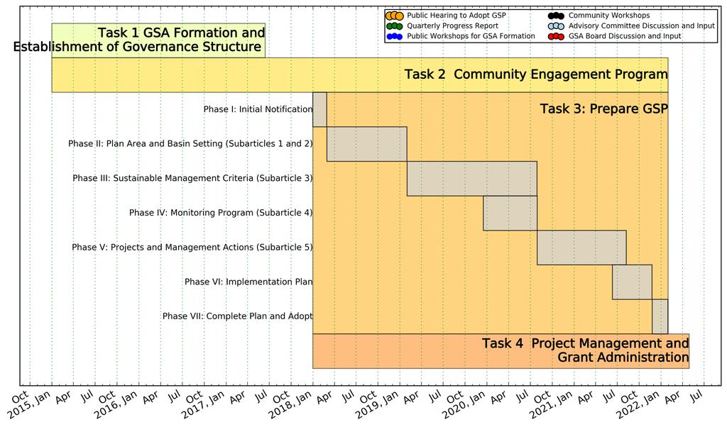
37