Des Plaines River Watershed Plan
|
|
|
- Gyles Stokes
- 5 years ago
- Views:
Transcription


1 Des Plaines River Watershed Plan February 1, 2017 FUNDING FOR THIS PROJECT PROVIDED, IN PART, BY THE ILLINOIS ENVIRONMENTAL PROTECTION AGENCY THROUGH SECTION 319 OF THE CLEAN WATER ACT.
 Flows into Sanitary")

2 Des Plaines River Watershed Planning Area: 235 square miles (150,361 acres) Flows into Sanitary and Ship Canal, the Illinois and the Mississippi Rivers Des Plaines River Watershed Gulf Hypoxia Dead Zone
 Mill Creek (2014) Buffalo Creek (2015) No Plan Approved Newport Drainage Ditch Upper Des Plaines Lower Des Plaines Aptakisic")
3 Des Plaines Subwatersheds 6 Previously Approved Watershed-Based Plans Bull Creek/Bulls Brook (2009) Indian Creek (2009) North Mill Creek-Dutch Gap Canal (2013) Mill Creek (2014) Buffalo Creek (2015) No Plan Approved Newport Drainage Ditch Upper Des Plaines Lower Des Plaines Aptakisic Creek
4 About This Project Create an umbrella watershed-based plan for the Des Plaines River Watershed Goals to reduce nonpoint source pollution, mitigate flood damage, protect natural resources The Des Plaines Watershed Workgroup (DRWW) is monitoring water quality


5 Why a Watershed Plan? Clean water, healthy lakes and streams, safety from flooding are important for residents & businesses Existing problems: o Lake County and downstream water quality impairments o Flood damage H 2 O doesn t flow with political boundaries, planning improves coordination & cooperation among communities Population and land use change influences Eligibility for grant funds for plan implementation
6 Watershed Plan Content 1. Introduction 2. Goals & Objectives 3. Watershed Characteristics Assessment 4. Watershed Problem Assessment (Consultant) 5. Flood Damage Problem Assessment 6. Prioritized Action Plan (Consultant) 7. Implementation and Evaluating Plan Performance (Consultant) 8. Education and Outreach Strategy
7 Watershed-Based Plan 9 Elements (Consultant Deliverables) 1. Identification of the causes and sources of pollution 2. Estimate of the pollutant load reductions expected 3. Description of nonpoint source management measures & critical areas 4. Estimate of technical and financial assistance needed 5. Public information/education component (SMC) 6. Plan implementation schedule 7. Description of interim, measurable milestones 8. Criteria to determine whether pollutant loading reductions met 9. A monitoring component (Review and recommend changes to DRWW monitoring strategy as needed)
8 RFP: Consultant Assistance Watershed Plan Components Watershed Problems Assessment pollutant load model, causes & sources of pollution, critical areas Action Plan - programmatic and prioritized sitespecific action plan with implementation schedule Plan Implementation includes pollutant load reduction calculations, technical and financial assistance needed (action plan implementation costs) Plan Evaluation measureable milestones, success criteria and evaluation tool, and water quality monitoring strategy
9 Plan Review and Adoption Review/Revision Phases 1. Stormwater Management Commission 2. ~45 day public review 3. IL EPA, stakeholders including DRWW, Adoption 1. Stormwater Management Commission 2. Lake County Board 3. DRWW 4. Municipalities/Townships 5. Other stakeholder organizations
10 Process and Timeline Stakeholder planning group is guiding the planning process SMC hosts 20 planning meetings 2016-early 2018 o 8 watershed-wide planning meetings (3 in 2016) o 12 topic-focused meetings (6 in 2016) Meeting materials are available on the SMC website Draft Plan will be delivered to IL EPA February 2018 IL EPA and Stakeholder Review March-April 2018 Final Plan will be delivered to IL EPA by May 31, 2018 SMC & County adoption of WBP June-July 2018
11 Watershed Characteristics
12 Watershed Assessment Methods Use Existing Studies, Reports, Information to Assess Watershed Character & Condition Fill in Holes by Collecting New Field Data: Stream, River, Detention Basin and Lake Shoreline Inventories Monitor Water Quality in Lakes & Streams (DRWW) Flood Problem Area Update and Flood Questionnaire Forecast Future Conditions Model Nonpoint Pollution Loads Map Green Infrastructure System
13 Identifying Critical Areas Highly erodible soils on agricultural land and future development sites Severe lake shoreline erosion Severe streambank erosion Problem discharge points & hydraulic structures Poor buffers along stream corridors Highly vulnerable land use catchments Pollutant loading hotspot catchments

14 Planning Jurisdictions Extent: Kenosha County, WI; Lake County & Cook County, IL Portions of 38 municipalities; 18 townships Unincorporated Lake County 30% of watershed
15 Topography Landscape formed by last glaciation Watershed drains to the southeast Topography used to delineate watersheds and used to produce planning models
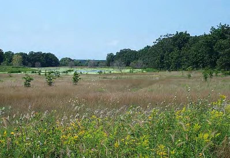
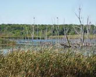
16 Water Resources 241 miles of streams 28,863 acres wetlands 7,975 acres of open water 6,824 acres of High Quality wetlands 114 named lakes

17 Catchments Mapped 422 catchments delineated for: Nonpoint pollutant load modeling Identifying Critical Areas Action plan recommendations

18 High Quality Natural Resources 24 Natural Area Inventory Sites 41 Forest Preserves/County Parks 20 Nature Preserves ~55 Threatened & Endangered Species

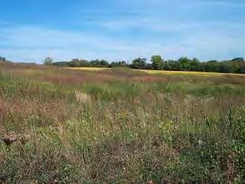

19 Historic Landscape Oak Woodland/Savanna Wet Prairie Prairie Marsh


20 Current Landscape Agriculture Residential Open Space Commercial/Industrial White Slough Wetland
21 Demographics Categories Population 358, ,232 Households 145, ,403 Employment 195, ,942 Sources: CMAP Southeastern Wisconsin Regional Planning Commission

22 Projected Land Use Changes Sources: Lake County Southeastern Wisconsin Regional Planning Commission Chicago Metropolitan Agency for Planning


23 Impacts of Land Use Change Changes in land use impact watershed hydrology and alter stormwater runoff characteristics


24 Stormwater Impacts on Streams Resulting stream channel Typical historic stream channel Channel downcutting and widening Source: Cruse et al., 2012

25 Stream Inventory SMC stream inventories used to objectively assess stream reaches or segments Characteristics Inventoried: Channel Conditions Hydraulic Structures Discharge Points Riparian Corridor Aquatic Habitat Snapshot assessment of overall stream condition

26 Approximately 246 miles of inventoried streams: North Mill Creek Mill Creek Buffalo Creek miles Bull s Brook Bull Creek Indian Creek Newport Drainage Ditch miles Des Plaines River miles including 38 miles of the Des Plaines River mainstem.


27 Channel Conditions & Hydraulic Structures Channel conditions include dimensions, erosion & sediment, and channelization Measure all in-stream (hydraulic) structures such as dams, culverts, and bridges, & note any obvious issues


28 Discharge Points, Riparian Corridor, & Aquatic Habitat Discharge points include the outlets of storm sewers, drainage ditches, and all drainage pipes and tiles >4 in diameter, note obvious issues Note riparian corridor and aquatic habitat characteristics in all reaches


29 26 Miles No/Slight Channelization 20% make labels readable 64 Miles Low Channelization 48% 29 Miles Moderate Channelization 22% 13 Miles High Channelization 10%


30 52 Miles No/Slight Bank Erosion 30% 107 Miles Moderate Bank Erosion 61% 17 Miles Severe Bank Erosion 10% 274 Areas Identified for Recommended Maintenance
31 810 Hydraulic Structures Identified 92 (11%) Identified as problems/maintenance recommended

32 1022 Discharge Locations Identified 181 (18%) Identified as problems/maintenance recommended Notes: COULD BE THE PIPE ITSELF, DISCHARGE OR DITCH OR SWALE
 Identified as Obstructing")
33 2073 Identified Debris Jams 1553 (75%) Identified as Obstructing Flow
34 Inventory Output & Results Output: Discharge Points (pipes/tiles) = 1022 total, 181 potential problems Swale/Open Channel = 421 total, 36 problem and/or maintenance required Debris Jams = 2073 total, 1553 marked as obstructing flow Inventory results used to: Compile a general inventory report for the watershed Create maps and tables to compare conditions across the watershed Formulate action plan recommendations for restoration and retrofits Hydraulic Structures = 810 total, 92 potential problems

35 Stream Water Quality Illinois EPA-Designated Uses in DPR Watershed: Aquatic Life Fish Consumption Primary Contact (swimming) Aesthetic Quality Nonsupport of Use = Impairment Mouth of Bull Cr. (Left) at Des Plaines River, 2006 Physical, chemical, & biological factors
36 Impaired Segments Assessed Segments 12 Impaired (6 on DPR) 16 Causes 53 Total Impairments Mercury, Arsenic, Phosphorus, & Dissolved Oxygen most common causes

37 High Quality & Non-Assessed Streams Biological surveys indicate a few higher-quality reaches (Bull s Br., Mill Cr.) Many streams NOT assessed, and no data exist


38 2016 Stream DRWW Monitoring Map Monitoring Effort 70 Sites in watershed Little Pend Oreille Wildlife Refuge Water Quality Research Physical, chemical, biological, & flow data Data will be used to inform action plan

39 Lakes Lake (> 6 acres) Totals: Lakes greater than 6 acres = 88 Lakes greater than 20 acres = 55 Various Origins: Glacial Wetland-type Old gravel pits Etc
.")
40 Lake Water Quality Insert Map Water quality is variable (some good/bad) 61 of the waterbodies in the watershed are impaired for at least one designated use (IL EPA). o Examples: recreational impairment (too many weeds ), fecal coliform, turbidity, phosphorus
 Phosphorus (current and")

41 Water Quality in Lakes Main Concerns: Turbidity (suspended solids) Phosphorus (current and historic) Dissolved oxygen Aquatic plants Invasive species (Eurasian milfoil, zebra mussels, carp) Chlorides


42 Des Plaines River Watershed Lakes (Lake Co.)
43 Increased concentrations of Cl- measured in Lakes in Lake County Illinois Samples collected between Apr. Oct. Graph from Walt Kelly, Illinois State Water Survey


44 Harmful Algae Bloom (HAB) Toxins Cyanobacteria (blue-green algae) Dermal Ingestion Aerosol

, chloride 1 x / month Aquatic")
45 Lake Measurements Water quality: dissolved oxygen, conductivity, ph, water temperature, nutrients (phosphorus, nitrogen), chloride 1 x / month Aquatic Plants 1-2 x / year
46 Constructed Drainage System Detention Basin Inventory Map Stormsewer System


47 Detention Basin Inventory Identify and map all basins & conduct site visit Document existing conditions Identify potential management or retrofit opportunities Formulate watershed plan recommendations

48 Green Infrastructure & Watershed Planning Stormwater management benefits at site & watershed scales: Runoff reduction Water quality Flood damage reduction Parcels prioritized based on water quality, flood reduction and natural resources green infrastructure criteria
49 Components of a Watershed Green Infrastructure Network Action Plan Open space areas Riparian corridors Wetlands Floodplains Potential restoration sites Site-level BMPs


50 Site-Scale Green Infrastructure Action Plan Recommendations: Best Management Practices (BMPs) that maintain natural hydrologic functions Rain gardens Bioswales Naturalized detention Porous pavement Green roofs Filter strips & vegetated drainageways


51 Watershed-Scale Green Infrastructure Action Plan Recommendations: Network of open spaces & natural areas that mitigate runoff, recharge aquifers, & improve water quality Provide recreational opportunities & habitat Network of hubs and links


52 Source: Suwannee River Water Management District Floodplain Restudied in 2000 by US Army Corps of Engineers Revised study fixed errors, oversights, and inaccuracies of original study

53 Structures in the Floodplain Assessment started in 1996; Currently ongoing by SMC Staff 193 areas identified affecting ~3656 structures Structures damaged by flood events include transportation and utility infrastructure
")
54 Flood Problem Area Inventory Lake County 1995 inventory updated in 2002 Updated again for this watershed plan (including Wisconsin and Cook County data): Letters/survey to municipalities and other jurisdictional agencies Letters/survey to residents in known FPA s and in the 100- year floodplain Flood survey to general watershed stakeholder list SMC Code/Site Cause of Flooding Area (acres) Local Drainage Depressional Storage Local Drainage Depressional Storage Depressional Storage Depressional Storage


55 Flood Problem Areas and Survey Results used for Action Plan recommendations
56 Consulting Assistance Timeframe Task Project Coordination (Project kick-off and follow-up coordination meetings with SMC) Develop Watershed Expertise (Review draft watershed plan chapters data and studies. Optional windshield tour of watershed may be appropriate.) Timeframe March 2017-May 2018 March-October 2017 Attend Watershed Stakeholder Meetings (5-6 stakeholder meetings) May 2017-May 2018 Watershed Problem Assessment: (Causes and Sources of Pollution; Pollutant Model w/nonpoint Pollutant Load Analysis; Identify Critical Areas) March-October 2017 Prioritized Watershed Action Plan: (Site-Specific and Programmatic Actions w/lead responsibility, schedule, est. cost and priority rank) June-November 2017 Plan Implementation: (Pollutant Load Reductions, Cost Estimates, Implementation Milestones, Performance/Progress Evaluation and augment DRWW Water Quality Monitoring Strategy if/as needed.) June-November 2017 Consultant s complete draft report due to SMC November 15, 2017 SMC review comments to Consultant December 29, 2017 Consultant revisions to draft report due to SMC January 19, 2018 SMC delivers draft watershed plan to IL EPA February 28, 2018 Consultant and SMC present draft plan to stakeholders and DRWW March 2018 Stakeholder, DRWW and IL EPA comments received April 15, 2018 Final revisions to Consultant portions of draft plan due to SMC May 15, 2018 Final watershed plan report delivered to IL EPA by SMC May 31, 2018
57 Proposals Due 10 AM February 13, 2017 Firm s approach to project Project schedule Experience of project personnel Firm s experience/smc contract history Cost estimate Proposed modifications to scope w/ rationale GIS capabilities Keep proposal brief with information relevant to this project and assigned project team
58 Proposal Evaluation Project Approach - 15 points Project Team s Experience with Watershed Plan Development - 40 points Firm s Experience with Watershed Plan Development/Previous SMC Contracts - 15 points Project Schedule - 10 points Firm s Proximity to / Knowledge of the Study Area - 10 points Proposed Fee - 5 points Proposal Format and Quality - 5 points
59 For More Information You can follow the planning process and view meeting documents at: ntywatersheds/desplainesriver/pages/default.aspx RFP Contact: Patty Werner