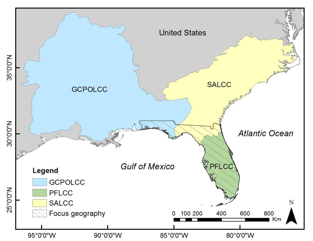
Peninsular Florida Landscape Conservation Cooperative. Marine and Estuarine Priority Resources and Conservation Targets
|
|
|
- Eleanor Lucas
- 5 years ago
- Views:
Transcription
1 Peninsular Florida Landscape Conservation Cooperative Marine and Estuarine Priority Resources and Conservation Targets
2 Today s Webinar Overview of Peninsular Florida Landscape Conservation Cooperative Priority Resources and Conservation Targets Marine and Estuarine Systems

3 The Landscape Conservation Cooperatives 22 individual, self-directed partnerships North American continent, Pacific Islands and the Caribbean Applied conservation science partnerships: Federal agencies Regional organizations State agencies Tribes NGOs Private stakeholders Universities Other entities
4
5 Peninsular Florida Landscape Conservation Cooperative (PFLCC) An applied conservation science partnership among local, state, and federal agencies, tribes, non-governmental organizations, universities, and other stakeholders to benefit fish and wildlife and associated habitats. The function of the PFLCC is to facilitate landscape-level 1) planning, 2) design, and 3) implementation of conservation strategies for fish and wildlife species
6 PFLCC Science Plan: Ecological Planning Conservation Design Conservation Delivery Research and Monitoring Data Sharing and Coordination Identifying priority resources and establishing conservation targets is an essential part of the Ecological Planning component
7
8


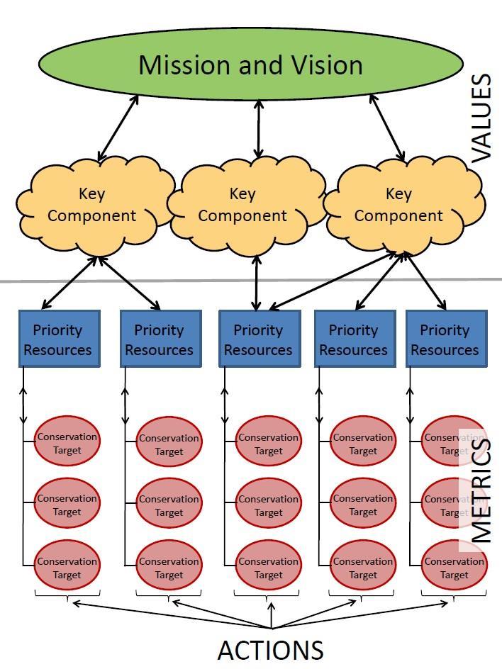
9 Priority resources are the set of biological, ecological, and cultural features and ecological processes collaboratively identified as most important, and are the focus of the PFLCC s planning. Priority resources should represent the most significant resources for the focus geography, embody the key components, and reflect the mission, vision, common interests, and values of the focus geography partners.
10 Development of Priority Resources PFLCC Technical Team by recommendation of PFLCC Steering Committee members USFWS, FWC State Wildlife Action Plan (SWAP) serve as starting point to define priority resources (PFLCC Steering Committee) Habitats in SWAP should be selected to best represent key components Additional priority resources beyond SWAP may be necessary and should be included to completely represent key components
11 PFLCC Priority Resources DRAFT list developed by Technical Team and approved by PFLCC Steering Committee Identified 12 priority resources: 9 habitat based 3 additional PRs, non-habitat based High Pine and Scrub Coastal Uplands Pine Flatwoods and Dry Prairie Freshwater Forested Wetlands Hardwood Forested Uplands Freshwater Non-Forested Wetland Freshwater Aquatic Estuarine Marine Cultural Working Lands and Socio-economic Landscape Connectivity


12 Conservation targets (indicators) are the measurable expressions of desired resource conditions. More specifically, conservation targets are the quantifiable biological, chemical, physical, or cultural attributes of a landscape that are important or valued to stakeholders identified during the biological planning process. Conservation targets consist of three elements: the measurable attribute: quantifiable characteristic that informs about landscape conditions the metric: unit of measure the target: numerical endpoint of measurable attribute

13 Primary Criteria for Conservation Target Selection
14 Examples of Conservation Targets Priority Resource Measurable Attribute Metric Priority Resource: Estuarine Target Estuarine Mangrove Extent Hectares (ha) Maintain 230,704 ha Coastal Uplands Pine Flatwoods and Dry Prairie Amount of altered beach Bird habitat suitability Linear miles Index of habitat suitability Reduce amount of altered beach by 25% by 2030 Achieve and maintain high status on 80% of pine flatwoods
15

16
17
18 Questions?? Staff: Todd Hopkins Coordinator, Beth Stys Science Coordinator, Steve Traxler Science Coordinator, Sarah Friedl Marine/Estuarine Project Lead, Cherie Keller GIS Coordinator, Caroline Gorga FWC Legacy Initiative, Web page Conservation Planning Atlas Guidance document

19 Peninsular Florida Landscape Conservation Cooperative Priority Resources Marine/Estuarine
20 Draft Priority Resources Hardwood Forested Uplands High Pine & Scrub Pine Flatwoods & Dry Prairie Freshwater Forested Wetlands Freshwater Non-Forested Wetlands Coastal Uplands Freshwater Aquatic Estuarine Marine Working Lands (WL 1, WL2)* Cultural and Socio-Economic Landscape Connectivity
21 Sub Resources Salt Marsh Mangrove Coral Seagrass Selected Classification systems Cooperative Land Cover Map (CLC) Coastal & Marine Ecological Classification Standard (CMECS) Extent 200m bathymetric line
22 Cooperative Land Cover V m Raster Vector Statewide Update in 2014 Moving forward - Partnership between the FWC and FNAI to maintain/update Continuously updated: New versions released every 6 12 months
23 CLC Estuarine Classifications Estuarine (5000) Subtidal (5100) Intertidal (5200) Exposed Limestone ( ) Tidal Flat ( ) Oyster Bar (5230) Salt Marsh (5240) Mangrove ( )
24 CLC Marine Classification Extends only to state waters No distinct classifications Includes only: Marine (6000) Surf Zone (6100)
25 CLC Classification System Mangrove 5250 Mangrove Swamp 5251 Buttonwood Forest 5252 Scrub Mangrove Saltmarsh 5240 Salt Marsh 5241 Salt Flat 5242 Cordgrass 5243 Needlerush
26 CMECS Classification System Estuarine System Tidally influenced waters Open-surface connection to the sea Regularly diluted by freshwater runoff from land Have some degree of land enclosure Tidal riverine coastal Tidal riverine open water Coastal Open water
27 CMECS Classification System Marine System 35 ppt All non-estuarine waters Coastal indentations/bays with little freshwater input River plumes that discharge into marine waters (e.g., Mississippi River plume, Chesapeake Bay plume) Nearshore (30 m depth contour) Offshore (Continental shelf break, ~200 m depth contour) Oceanic (>200 m depth/continental shelf break)
28 Preliminary Maps

29 Sources: FWRI Saltmarsh Habitat CLC V 3.2 Charlotte Harbor NEP
30 Sources: FWRI Mangrove Habitat FWRI ESI Shoreline Classification CLC V 3.2
31 Sources: FWRI Coral/Hardbottom Habitat FWRI Unified Reef Map FWRI Acropora presence, priority sites
32 Sources: FWRI NOAA Office of Coastal Management TNC SABMA
33 Data Catalog Marine mammals Cetaceans Manatees Migratory birds Sea turtles Oyster reefs Benthic cover EFH/HAPC Critical habitat Landcover Reef fish Migratory fish Reefs Wetlands Etc.
34 Next Steps Conservation Target Identification Workshops 4/25 4/27/17 Saint Petersburg, FWRI Building 5/2 5/4/17 Panama City, NOAA SEFSC 5/16 5/18/17 Gainesville, DPI Doyle Conner Building 6/20 6/22/17 Davie, UF-IFAS FLREC