Partnering for Resilient Infrastructure and Ecosystems in Massachusetts
|
|
|
- Liliana Osborne
- 5 years ago
- Views:
Transcription

1 Partnering for Resilient Infrastructure and Ecosystems in Massachusetts Northeastern Transportation & Wildlife Conference September 10 th, Tim Dexter, MassDOT Highway Division Brad Chase, MA Division of Marine Fisheries


2 Presentation Overview Overview of DOT Climate Change, Vulnerability, Adaptation & Ecological work, and associated Partners MA Division of Marine Fisheries Coordination

3 Executive Order 569: An integrated Climate Change Strategy for the Commonwealth Reducing greenhouse gas emissions to combat climate change Protecting life, property, natural resources and our economy from the impacts of climate change State Plan Agency Vulnerability Assessments Municipal Support Climate Coordinators


4 Mapping Our Vulnerable Infrastructure Tool - MOVIT Purpose: Map locations of repeat flooding, erosion, and infrastructure structure damage to storms Partners: MassDOT- ENV, GIS, District Operations & Maintenance


5 Deerfield River Watershed Vulnerability Analysis Purpose: Comprehensive analysis of stream crossings for structural, hydraulic and geomorphic risk, potential for disruption of emergency services and aquatic connectivity Partners: MassDOT, FHWA, UMass Transportation Center, North Atlantic Connectivity Collaborative

6 Statewide Flood Resiliency Analysis Purpose: Evaluate flood resiliency of MassDOT infrastructure (i.e., roads, culverts, and bridges) to improve asset management Partners: FHWA, MassDOT

7 Central Artery Climate Change & Extreme Weather Study Purpose: Identify extreme weather vulnerabilities under current & predicted climate scenarios Partners: FHWA, UMass Boston, Woods Hole Group, UNH, MassDOT

8 MA Coastal Vulnerability Study Purpose: Expand the Central Artery Study to the MA Coast & identify vulnerabilities to transportation network & coastal communities Partners: MassDOT, EEA FEMA

9 MassDOT Project Intake Tool - MaPIT Purpose: Web-based project initiation application, with automated transportation, safety, environmental & vulnerability analysis & reporting Partners: FHWA, MassDOT, ENV agencies, Baystate Roads, UMass Transportation Center

10 Wildlife Collisions Collector App Purpose: Wildlife roadway mortality mobile app Partners: MassDOT, MassWildlife

11 MassDOT Stream Crossing Handbook Purpose: Guidance on meeting MA River & Stream Crossing Standards; constraints analysis; conceptual design guidance Partners: MassDOT, MassWildlife, MassDEP, ACOE, DMF, DER, NMFS, CZM, EPA, CEI, MA Stream Continuity Partnership


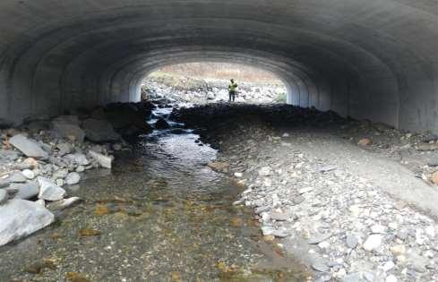
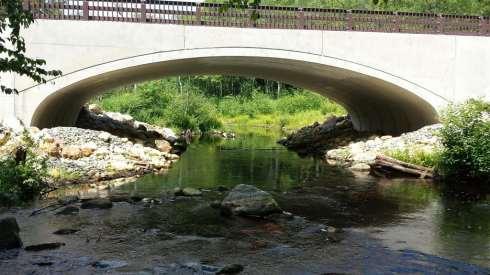
12 Stream Crossing Design
13 Wildlife Passage Bench Design MN DNR

14 Diadromous Fish Restoration Tool Purpose: Map diadromous fish presence/absence, and fish passage & blockage locations. Partners: DMF, MassDOT, MassWildlife


15 Fishways, Fish Ladders & Eel Ramps Purpose: Restore fish DOT project sites Partners: DMF, NMFS, MassDEP, CZM, MassDOT Morey s Dam, Taunton, MA

16 Diadromous Fish Culverts Purpose: Coordinate culvert maintenance, plan for future upgrades Partners: DMF, MassDOT, Dennis MA Natural Resources Department


17 Artificial Reef Collaboration Purpose: Reuse certain construction materials to create marine reef habitat Partners: DMF, MassDOT Highway & Rail Divisions
18 THANK YOU Tim Dexter Fish & Wildlife Supervisor Environmental Services MassDOT Highway Division (857)