November 19, 2013 JOINT PUBLIC NOTICE SAM U.S. ARMY CORPS OF ENGINEERS
|
|
|
- Magdalene Manning
- 5 years ago
- Views:
Transcription

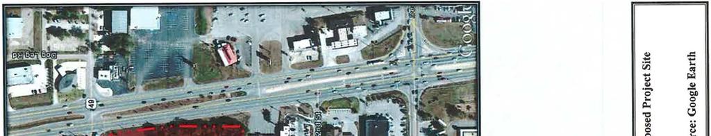
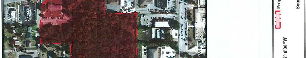
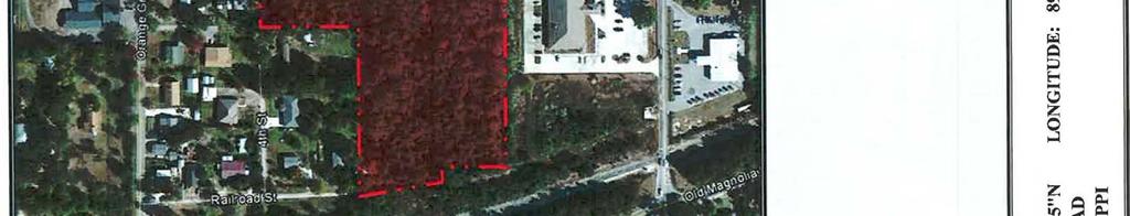
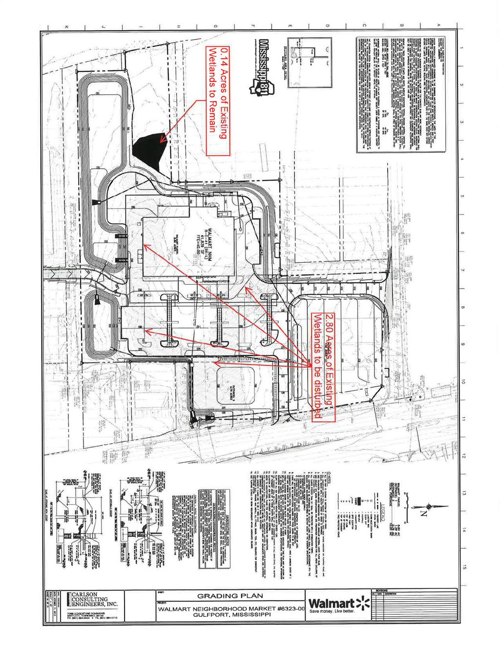
1 DEPARTMENT OF THE ARMY U.S. ARMY ENGINEER DISTRICT, MOBILE DISTRICT P.O. BOX 2288 MOBILE, ALABAMA November 19, 2013 Mississippi Branch Regulatory Division JOINT PUBLIC NOTICE SAM U.S. ARMY CORPS OF ENGINEERS MISSISSIPPI DEPARTMENT OF ENVIRONMENTAL QUALITY OFFICE OF POLLUTION CONTROL TO WHOM IT MAY CONCERN: MISSISSIPPI DEPARTMENT OF MARINE RESOURCES DMR PROPOSED IMPACTS ASSOCIATED WITH THE CONSTRUCTION OF A COMMERCIAL DEVELOPMENT GULFPORT, HARRISON COUNTY, MISSISSIPPI This District has received an application for a Department of the Army permit pursuant to Section 404 of the Clean Water Act. Please communicate this information to interested parties. APPLICANT: Sam Walton Development Complex 2001 Southeast 10 th Street Bentonville, Arkansas AGENT: Carlson Consulting Engineers, Inc. Attention: Mr. John Parrish 7068 Ledgestone Commons Bartlett, Tennessee LOCATION: In wetlands associated with the Flat Branch and Bernard Bayou, Section 9, Township 7 South, Range 11 West, City of Gulfport, Harrison County, Mississippi (Latitude North, Longitude West). WORK: The applicant proposes to construct a commercial development consisting of a 41,839- square-foot steel frame building, 169 parking spaces, all necessary utilities, 2 out lots for sale and use by others and a sediment basin. The subject property is located at the southwest intersection of U.S Highway 49 (U.S. 49) and Orange Grove Road in Gulfport. The subject property is approximately acres in size and contains approximately 2.94 acres of jurisdictional wetlands. The applicant is proposing to utilize approximately 23,000 cubic yards of clean fill material to fill approximately 2.80 acres of jurisdictional wetland for the proposed development. The remaining 0.14 acre would be left undisturbed. The proposed work would consist of site clearing, site grading and filling, paving and construction of the proposed structures.
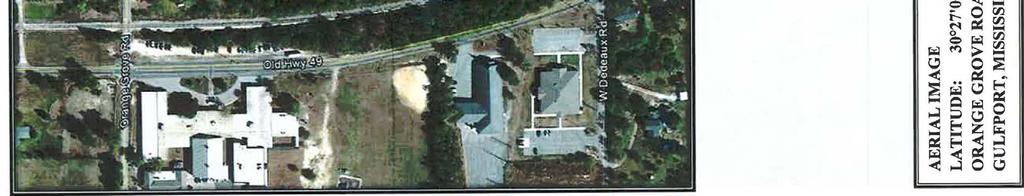
2 CESAM-RD-C November 19, 2013 SAM Page 2 of 4 EXISTING CONDITIONS: The property is located within a highly developed area of Gulfport, along the U.S. 49 corridor. The project site consists of an existing road frontage commercial property and undeveloped land. The northeastern portion of the site, fronting U.S. 49 with ingress and egress from Orange Grove Road, had previously been developed and had a commercial business located on it. The property has rolling topography with the highest portion located along the Orange Grove Road frontage and sloping towards two valleys that converge east of a small ridge near the central portion of the site. The southern valley flows from west to east and then turns north to converge with the northwestern valley. The northwestern valley flows from northwest to southeast where it merges with the southern valley and flows east to exit the property through a storm drainage structure underneath U.S. 49. The site is bounded to the north by Orange Grove Road and to the east by U.S. 49. Land use to the northwest of the site is primarily residential; while the areas to the south and east are heavily commercial. Moving westward of the site is an overhead utility easement, a railroad line, Old U.S. 49 and an elementary school. The property contains two low areas that converge near the center of the site and makeup the boundaries of jurisdictional wetlands. No streams or other waters of the United States were observed. PROJECT PURPOSE: As stated by the applicant, The purpose of the proposed project is to serve a growing Gulfport community and surrounding areas. City officials welcomed the proposed project and stated there is not much diversity when it comes to grocery shopping. The U.S. Army Corps of Engineers (Corps) initially determined the basic project purpose is for the construction of a commercial retail development with amenities and would not be considered a water dependent activity. Additional review will be performed by the Corps and cooperating agencies. ALTERNATIVES: The Corps initial review of alternatives submitted by the applicant consists of potential sites all located within the U.S. 49 corridor. One site was eliminated due to size and wetland issues; a second site was eliminated due to size and a third site was eliminated because it consisted of 8 parcels and an agreement could not be reach between all parties involved. The site selected had adequate size, access to U.S. 49 and consisted of 2 parcels belonging to 1 owner. Additional review of alternatives will be performed by the Corps and cooperating agencies. MITIGATION: Mitigation for the loss of ±2.94 acres of low quality Cypress-Bay-Gum bottomland forested wetlands, composed primarily of trees and underbrush dominated by Acer rubrum, Ligustrum sinense, Magnolia virginiana and Cinnamomum camphora, is proposed through the purchase of 6.0 credits from the Wetland Solutions Mitigation Bank. Additional review of mitigation requirements will be performed by the Corps and cooperating agencies. Final compensatory mitigation will be evaluated by the Corps and cooperating resource agencies throughout the review process for the proposed project. The applicant has applied for certification from the State of Mississippi in accordance with Section 401(a)(1) of the Clean Water Act and upon completion of the required advertising; a determination relative to certification will be made. The applicant has received coastal zone consistency from the State of Mississippi Department of Marine Resources in accordance with Section of the Mississippi Code Annotated, by October 21, 2013 letter (DMR ).
3 CESAM-RD-C November 19, 2013 SAM Page 3 of 4 This public notice is being distributed to all known interested persons in order to assist in developing facts on which a decision by the Corps can be based. For accuracy and completeness of the record, all data in support of or in opposition to the proposed work should be submitted in writing setting forth sufficient detail to furnish a clear understanding of the reasons for support or opposition. The decision whether to issue a permit will be based on an evaluation of the probable impact, including cumulative impacts, of the proposed activity on the public interest. That decision will reflect the national concern for both protection and utilization of important resources. The benefits, which reasonably may be expected to accrue from the proposal, must be balanced against its reasonably foreseeable detriments. All factors, which may be relevant to the proposal, will be considered, including the cumulative effects thereof; among those are conservation, economics, aesthetics, general environmental concerns, wetlands, cultural values, fish and wildlife values, protected species, flood hazards, flood plain values, land use, navigation, shoreline erosion and accretion, recreation, water supply and conservation, water quality, energy needs, safety, food production and in general, the needs and welfare of the people. The Corps is soliciting comments from the public; Federal, State and local agencies and officials; Indian Tribes; and other interested parties in order to consider and evaluate the impacts of this proposed activity. Any comments received will be considered by the Corps to determine whether to issue, modify, condition or deny a permit for this proposal. To make this decision, comments are used to assess impacts on endangered species, historic properties, water quality, general environmental effects and the other public interest factors listed above. Comments are used in the preparation of an Environmental Assessment and/or an Environmental Impact Statement pursuant to the National Environmental Policy Act. Comments are also used to determine the need for a public hearing and to determine the overall public interest of the proposed activity. Any person may request, in writing, within the comment period specified in this notice, that a public hearing be held for consideration of this application. Requests for public hearings shall state with particularity, the reasons for holding a public hearing. Evaluation of the probable impacts involving deposits of dredged or fill material into waters of the United States will include the application of guidelines established by the Administrator of the U.S. Environmental Protection Agency. In accordance with Section 106 of the National Historic Preservation Act, and Appendix C of 33 CFR 325, the undertaking defined in this notice is being considered for the potential to effect cultural and historic properties within the permit area. The State Historic Preservation Officer (SHPO) has commented to notice from MDMR by October 7, 2013 letter. SHPO reviewed a submitted Phase I Archaeological Resources Survey and concur that no known cultural resources listed in or eligible for listing in the National Register of Historic Places are likely to be affected within the project area surveyed (MDAH Project Log # ). In accordance with Appendix C of 33 CFR Part 325, the Corps has determined that the permit area is the full area of development for the overall project footprint. The Corps will consult with the State Historic Preservation Officer to make a final determination based upon this review unless comment to this notice is received documenting that significant sites or properties exist which may be affected by this work or that adequately documents that a potential exists for the location of significant sites or properties within the permit area.
4 CESAM-RD-C November 19, 2013 SAM Page 4 of 4 The U.S. Fish and Wildlife Service (FWS) lists 16 endangered, threatened or candidate species as occurring or potentially occurring in Harrison County. These include the gopher tortoise (T)(Gopherus polypemus), the Louisiana quillwort(e) (Isoetes louisianensis), the Mississippi gopher frog (E) (Rana capito sevosa), the Gulf sturgeon (TCH) (Acipenser oxyrinchus desotoi), the Red-cockaded woodpecker (E) (Picoides borealis), the Piping Plover (TCH)(Charadrius melodus), the Red knot (Calidris canutus rufa), the West Indian manatee (E) (Trichechus manatus), the Louisiana black bear (T)(Ursus americanus luteolus), the Alabama red-belly turtle (E) (Pseudemys alabamensis), the Black pine snake (C) (Pituophis melanoleucus lodingi), the Green sea turtle (T)(Chelonia), the Hawksbill sea turtle (E) (Eretmochelys imbricate), the leatherback sea turtle (E)(Dermochelys coriacea), the Kemp s ridley sea turtle (E) (Lepidochelys kempii) and the Loggerhead sea turtle (T) (Caretta caretta). Preliminary review of this application and the U.S. Department of the Interior List of Endangered and Threatened Wildlife and Plants for the 12-HUC watershed suggest that the proposed activity may affect but is not likely to adversely affect listed endangered or threatened species. Specifically, the Black pine snake, the Louisiana black bear and the Gopher tortoise may be affected by this project. Required habitat for the remaining listed species is not found on the proposed project site. By June 23, 2013 letter, the FWS stated the proposed project will have no effect on Federally listed species or their habitats. Correspondence concerning this Public Notice should refer to Public Notice Number SAM and should be directed to the District Engineer, Corps, Mobile District, Attention: Ms. Maryellen Farmer, 1141 Bayview Avenue, Suite 501, Biloxi, Mississippi 39530, Attention: USACE Biloxi Field Office, with a copy to the Mississippi Department of Environmental Quality, Office of Pollution Control, Attention: Ms. Florance Watson, P.E., Post Office Box 2261, Jackson, Mississippi and the Mississippi Department of Marine Resources, Attention: Ms. Willa Brantley, 1141 Bayview Avenue, Suite 501, Biloxi, Mississippi 39530, in time to be received within 30 days of the date of this public notice. If you have any questions concerning this publication, you may contact the project manager for this application, Ms. Maryellen Farmer (maryellen.j.farmer@usace.army.mil), phone (228) Please refer to the above Public Notice number. For additional information about our Regulatory Program, please visit our web site at: MOBILE DISTRICT U.S. Army Corps of Engineers Enclosures


5
6

7
8
9
10
11
12
13
14