Public Notice Corps of Engineers
|
|
|
- Kristina Hamilton
- 5 years ago
- Views:
Transcription

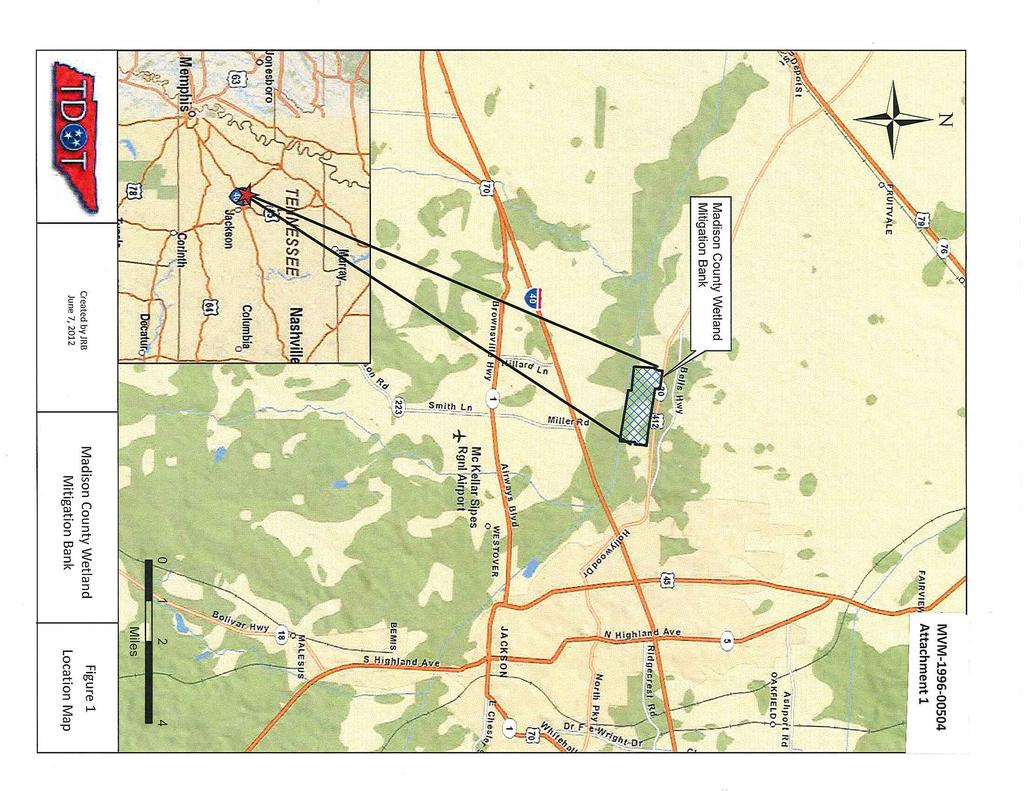
1 Public Notice US Army Corps of Engineers Memphis District REPLY TO ATTN: Roger Allan U.S. Army Corps of Engineers 167 North Main Street, Room B-202 Memphis, Tennessee Telephone: (901) Fax (901) POSTMASTER PLEASE POST UNTIL: PUBLIC NOTICE NO: MVM PUBLIC NOTICE DATE: September 27, 2013 EXPIRATION DATE: October 28, 2013 Public Notice Corps of Engineers AUTHORITY: Pursuant to 33 CFR 332.8(d)(4) (Mitigation banks and in-lieu fee programs, public review and comment), this notice announces the proposed modification of the existing Madison County Wetland Mitigation Bank (MCWMB). SPONSOR: Tennessee Department of Transportation Attn: Mike Williams 505 Deaderick Street Nashville, TN (615) LOCATION: The MCWMB includes approximately 778 acres located south of U.S. Highway 412 and north of the South Fork Forked Deer River (SFFDR) approximately 3 miles west of Jackson in Madison County, Tennessee. The approximate latitude and longitude of the bank site are N and W, respectively. A location map is provided as Attachment 1. PURPOSE: The purpose of this notice is to inform the public of a proposed modification to an existing wetland mitigation bank. This mitigation bank has generated and would continue to generate credits that could be used to meet compensatory mitigation requirements for future permits issued under Section 404 of the Clean Water Act for the deposition of dredged or fill material into waters of the U.S., under Section 10 of the Rivers and Harbors Act of 1899 for work within navigable waters of the U.S., or under the Tennessee Water Quality Control Act for permits issued by the Tennessee Department of Environment and Conservation. The original MCWMB was established under a Memorandum of Agreement (MOA) in The original plan was to restore approximately 424 acres of bottomland hardwood wetlands and establish approximately 50 acres of moist soil plants. As outlined by the sponsor, a combination of beaver activity and inadequate breaching of the levee that protected the site from flooding resulted in prolonged inundation of large portions of the site and high mortality of planted trees. Additionally, approximately 6 acres of the site were determined to include berms and other upland features; this reduced the total wetland area to approximately 468 acres. In , the levees which surrounded the site were removed and additional trees (62,000+) were planted within approximately 166 acres of the 468-acre restoration area. Despite its development as a wetland, portions of the site do not meet the standards established in the 1996 MOA. Additionally, the 1996 MOA does not meet the standards established in the 2008 Mitigation Rule. The following is a summary of the proposed modifications of the Mitigation Banking Instrument (MBI) for this project that would address current site conditions and bring the site into compliance with the mitigation rule; please see the complete proposed modified MBI (available online at for additional details.
2 -2- WATERSHED DETAILS: The sponsor notes that the bank site is located in the SFFDR 8-digit HUC ( ) and that the SFFDR and several of its tributaries are on the 303(d) list for such pollutants/problems as high levels of phosphorus, siltation, habitat alterations, Escherichia coli, and loss of littoral vegetative cover. The sponsor further notes that wetland restoration within 468 acres and additional establishment of upland buffers within former agricultural fields has likely led to reduction in sediment runoff and other site pollutants into the SFFDR. Additionally, the removal of the levees that surrounded the site has reconnected nearly 800 acres of floodplain to the SFFDR. OBJECTIVES: The original objectives for the site were to: (1) restore the natural drainage that was altered by ditches and levees; (2) reforest approximately 424 acres in bottomland hardwoods; and (3) establish approximately 50 acres of moist soil wetlands. Objectives 1 and 3 have been met. Objective 2 has only been partially met through the restoration of approximately 233 acres of bottomland hardwood wetlands. An additional 108 acres of emergent and open water/moist soil have successfully converted into cypress, tupelo and mixed hardwood wetlands since the remedial work in TDOT proposes to allow approximately 115 acres (or less) of the bank to remain as a combination of herbaceous and scrub-shrub wetlands and 11.5 acres (or less) as open water areas for open water areas for waterfowl habitat. As justification for the proposed modification, CEC, Inc., analyzed National Land Cover Dataset 1992 and National Wetlands Inventory data within the watershed. This analysis showed that approximately 80-82% of the wetlands in the watershed were forested, 5-12% were emergent/herbaceous, approximately 4% were scrub-shrub, and 8-9% were riverine or open water. The MCWMB is currently 82% forested, 16% emergent/scrub-shrub and 2% open water. SERVICE AREA: The original service area included the entire Forked Deer River 6-digit HUC as well as all counties contiguous with Madison County. The proposed service area would only include the Forked Deer River watershed (Figure 2). BASELINE CONDITIONS: Historically, this area was dominated by bottomland hardwoods but the bank site was in agricultural production when the bank was originally approved. Although other mapping units are present, the majority of the soils on the site are mapped as Falaya silt loam and Waverly silt loam. Prior to wetland restoration in 1997, a levee and a series of pumps and drainage ditches were used to keep the site dry enough to farm. MITIGATION WORK PLAN: Originally, trees (including swamp chestnut oak, willow oak, Nuttall oak, pin oak, cherrybark oak and bald cypress) were to be planted at a density of approximately 450 stems per acre. As proposed, the original work plan would be modified as follows: A diversity of species will be planted including cypress and tupelo in previously inundated areas and oaks will be planted in along the levee removal areas of the east field and in the drier portions of the west field. Habitat Community types within the proposed 468 acres of wetland restoration will consist of the following: 1) Open Water/Mud Flats; 2) Emergent/Herbaceous, Occasionally Inundated; 3) Scrub Shrub/Emergent; 4) Mixed Hardwoods; 5) Cypress/Tupelo/Mix Hardwoods; and 6) Cypress/Tupelo. No greater than 16.7% (130 acres) of the total BANK site shall include Open water/mud Flats, Emergent/Herbaceous, Occasionally Inundated, or Scrub/Shrub/Emergent as defined above. OPERATION AND MAINTENANCE PLAN: The sponsor notes that a primary goal of the project is a selfsustaining natural wetland system but adds that TDOT will be responsible for site maintenance. Minimal maintenance is anticipated beyond recent supplemental tree plantings and levee removal. However, periodic removal of invasive species and replanting of native hardwood species may be required in certain areas.
3 -3- ECOLOGICAL SUCCESS CRITERIA/PERFORMANCE STANDARDS: The sponsor has proposed new ecological success criteria and performance standards based on a comprehensive site evaluation completed in 2010 and monitoring in Current standards require at least 300 trees per acre of hard mast producing species which have been established on-site for 5 consecutive years within forested areas and 75% coverage of approved species for five consecutive years within established moist soil habitats. The sponsor has proposed to revised these standards as follows: 1. Minimum survival rates for vegetational plantings: a) An overall stem count of 200 trees per acre (including native volunteer hydrophytic tree species and buttonbush) as a gauge for determining vegetation success for restored hardwood bottomland wetlands. The large buffer of preservation wetland areas surrounding the site provides an abundant seed supply for regeneration of native hardwood species within the proposed restoration areas. b) In established moist soil (emergent wetland) habitats, 75% coverage of hydrophytic species as determined by the Regional Supplement to the Corps of Engineers Wetland Delineation Manual: Atlantic and Gulf Coastal Plain Region, November c) All plantings shall meet federal delineation specifications for hydrophytic vegetation as determined by the Regional Supplement to the Corps of Engineers Wetland Delineation Manual: Atlantic and Gulf Coastal Plain Region, November d) Approximately 1.5% of the total Bank site will remain as open water areas for waterfowl habitat. MONITORING REQUIREMENTS: As proposed, annual monitoring of the bank vegetation would continue to document the wetland characteristics of the site. Monitoring of vegetation would occur at a minimum of 14 permanently established monitoring stations. Data to be collected would include species composition and average height of woody vegetation (planted and volunteer species) as well as the indicator status of each species in the herbaceous stratum. Photographs would also be taken within each vegetation plot. The sponsor has requested to discontinue groundwater monitoring because the site has met hydrology requirements. This site has been monitored to some extent since TDOT proposes to monitor the site in 2013, 2014 and 2015 to document site conditions. PROPOSED OWNERSHIP ARRANGEMENTS: The State of Tennessee retains ownership of the property. The sponsor has signed an MOA with the Tennessee Wildlife Resources Agency (TWRA) that allows TWRA to manage the wildlife resources for the State and enforce laws associated with its use as a refuge. The sponsor proposes to add further restrictions to the site based on the Notice of Land Use Restrictions developed by the Tennessee Department of Environment and Conservation with additions by the Corps of Engineers. Low-impact, non-invasive public recreational uses such as hiking, wildlife viewing, hunting and educational uses would continue to be allowed on the site. Following closure of the bank, the sponsor would transfer the property to TWRA. LONG-TERM MANAGEMENT: TWRA will continue to manage the site as a wildlife refuge and will assume responsibility for the long-term management of the site. Future management goals and objectives would be developed with consideration to the terms and conditions of its restrictive covenant, wildlife habitat and public use. ADAPTIVE MANAGEMENT: To date, the sponsor has implemented adaptive management including removal of beaver dams, breaching/removal of levees and planting of additional trees. In the event that future monitoring indicates the need for additional corrective actions, the sponsor has proposed that the Interagency Review Team shall provide notice to TDOT. TDOT will then prepare an analysis of the cause of failure and determine the appropriate corrective action and a schedule of implementation. TDOT will be responsible for financing, developing and implementing contingency plans until closure.
4 -4- DETERMINATION OF CREDITS/CREDIT RELEASES/DEBITING OF CREDITS: The sponsor has not proposed to modify the credits generated on the bank (1 credit generated for each acre of restoration of hydrologic functions and vegetation on hydric soils); based on an analysis of current site conditions this would result in a total of 468 credits generated. To date, credits have been released for use at the bank and approximately 231 credits have been debited. TDOT is requesting the release of an additional 90.4 credits (approximately 19% of the total) based on current site conditions. TDOT has further proposed additional credit releases of 46.8 (10% of the total) following successful monitoring over the next 3 years. TDOT has proposed to mitigate in-kind impacts only at this site. As proposed, the new credit total would include credits for impacts to forested wetlands, 115 credits for impacts to emergent/scrub shrub wetlands, and 11.5 credits for impacts to open water/unconsolidated bottom wetlands. ENDANGERED SPECIES: No additional earth work is proposed for the bank. However, this project is being coordinated with the U.S. Fish and Wildlife Service. Any comments they may have regarding endangered or threatened wildlife or plants, or their critical habitat, will be considered in our evaluation of the described work. CULTURAL RESOURCES: No additional earth work is proposed for the bank. However, the Memphis District will evaluate information provided by the State Historic Preservation Officer, Federally-recognized Tribes and the public in response to this public notice and we may conduct or require a survey of the project area. FLOOD PLAIN: In accordance with 44 CFR Part 60 (Flood Plain Management and Use), participating communities are required to review all proposed development to determine if a flood plain development permit is required. Flood plain administrators should review the proposed public notice and apprise this office of any flood plain development permit requirements. PUBLIC INTEREST REVIEW: The purpose of this public notice is to advise all interested parties of the proposed activities and to solicit comments and information necessary to evaluate the probable impact on the public interest. The decision whether to authorize this mitigation bank will be based on an evaluation of the probable impact including cumulative impacts of the activity on the public interest. That decision will reflect the national concern for both protection and utilization of important resources. The benefits which reasonably may be expected to accrue from the project must be balanced against its reasonably foreseeable detriments. All factors which may be relevant to the project will be considered, including the cumulative effects thereof; among those are conservation, economics, aesthetics, general environmental concerns, wetlands historic properties, fish and wildlife values, flood hazards, floodplain values, land use, navigation, shoreline erosion and accretion, recreation, water supply and conservation, water quality, energy needs, safety, food and fiber production, mineral needs, considerations of property ownership and in general, the needs and welfare of the people. The Corps of Engineers is soliciting comments from the public; Federal, state and local agencies and officials; Federally-recognized Tribes; and other interested parties in order to consider and evaluate the proposed activity. Any comments received will be considered by the Corps of Engineers to determine whether to authorize this request. To make this decision, comments are used to assess impacts on endangered species, historic properties, water quality, general environmental effects and the other public interest factors listed above. Comments are used in the preparation of an Environmental Assessment and/or an Environmental Impact Statement pursuant to the National Environmental Policy Act. Comments are also used to determine the need for a public hearing and to determine the overall public interest of the proposed activity.
5 -5- PUBLIC HEARING: Any person may request, in writing, within the comment period specified in this notice that a public hearing be held to consider this prospectus. Requests for a public hearing shall state, with particularity, the reason for holding a public hearing. The District Engineer will determine if the issues raised are substantial and whether a hearing is needed for making a decision. If a public hearing is held, it will be for the purpose of obtaining additional information that we could not otherwise obtain through a public notice process and not to inform the public about the specific details of the project in greater detail than what is found in this notice. This is not a Corps project. We are not a proponent nor are we an opponent of the project. We are merely the permitting authority of Section 404 and Section 10 permits required by our office. COMMENTS OR REQUEST FOR ADDITIONAL INFORMATION: If you wish to obtain additional information or to submit comments on this project, please contact Roger Allan at the U.S. Army Corps of Engineers, 167 North Main Street, Room B-202, Memphis, Tennessee , telephone (901) Copies of all comments, including the names and address of commenters, may be provided to the bank sponsor for consideration and response prior to a decision by the Corps. For Final Individual Permit actions in the Memphis District, go to the following link: Using the Filter by District drop down box, select MVM-Memphis District, then select the year and month (information will populate in the table below). All pending individual permits can be located by selecting the Pending IP tab above. All of the environmental documents and statements of findings supporting issuance or denial of the permit decisions are available upon written request and where applicable, upon the payment of administrative fees. They are also available at the Memphis District, Regulatory Branch office for examination. Comments should be received by October 28, Gregg Williams Chief Regulatory Branch Attachments
6

7