August 19, 2016 Final EIR. General Plan Update Final Environmental Impact Report. for the City of San Leandro
|
|
|
- Lucas Maxwell
- 5 years ago
- Views:
Transcription


1 August 19, 2016 Final EIR General Plan Update Final Environmental Impact Report for the City of San Leandro State Clearing House Number:
2
3 August 19, 2016 Final EIR Submitted By: PlaceWorks 1625 Shattuck Avenue, Suite 300 Berkeley, California (f) General Plan Update Final Environmental Impact Report for the City of San Leandro State Clearing House Number: In Association With: Kittelson & Associates, Inc. Environmental Collaborative Tom Origer & Associates Barry J. Miller, FAICP ORANGE COUNTY NORTHERN CALIFORNIA LOS ANGELES INLAND EMPIRE SAN DIEGO
4
5 Table of Contents 1. INTRODUCTION Purpose of the Environmental Impact Report Environmental Review Process Report Organization EXECUTIVE SUMMARY REVISIONS TO THE DRAFT EIR Revisions to Chapter 1, Executive Summary Revisions to Chapter 3, Project Description Revisions to Chapter 4.2, Air Quality Revisions to Chapter 4.11, Population and Housing Revisions to Chapter 4.12, Public Services and recreation Revisions to Chapter 4.13, Transportation and Traffic Revisions to Chapter 5, Significant Unavoidable Impacts Revisions to Chapter 6, Alternatives to the Proposed Project Revisions to Appendices LIST OF COMMENTERS Comments on the Draft EIR Comments on the Merits of the Proposed Project COMMENTS AND RESPONSES APPENDICES Appendix B: Proposed Zoning Code Amendments Appendix I: Comments Received during the Public Review Period PLACEWORKS i
6 SAN LEANDRO GENERAL PLAN UPDATE FINAL EIR CITY OF SAN LEANDRO TABLE OF CONTENTS LIST OF TABLES Table 2-1 Summary of Impacts and Mitigation Measures Table 5-1 Comments and Response Matrix ii AUGUST 2016
7 1. Introduction 1.1 PURPOSE OF THE ENVIRONMENTAL IMPACT REPORT This document provides responses to comments received on the Draft Environmental Impact Report (Draft EIR) for the proposed San Leandro 2035 General Plan ( proposed Plan ) and Zoning Code amendments, herein together referred to as the proposed project. The Draft EIR identified significant impacts associated with the proposed project, and examined alternatives and recommended mitigation measures that could avoid or reduce potential impacts. This document, together with the Draft EIR, will constitute the Final EIR if the City of San Leandro City Council certifies it as complete and adequate under the California Environmental Quality Act (CEQA). 1.2 ENVIRONMENTAL REVIEW PROCESS According to CEQA, lead agencies are required to consult with public agencies having jurisdiction over a proposed project, and to provide the general public with an opportunity to comment on the Draft EIR. This Final EIR has been prepared to respond to comments received on the Draft EIR. The Draft EIR was made available for public review from June 1, 2016 through July 15, The Draft EIR was distributed to local, regional, and State agencies and the general public. Copies of the Draft EIR were made available for review to interested parties at: City Hall at 835 East 14th Street Main Library at 300 Estudillo Avenue The San Leandro 2035 General Plan website at The 45-day public comment period ended on July 15, Copies of all written comments received on the Draft EIR are contained in this document. These comments and responses to these comments are laid out in Chapter 5, Comments and Responses, of this Final EIR. This Final EIR will be considered at a Planning Commission public hearing on the proposed project, after which the Commission will make a recommendation to the City Council on certification of the EIR and approval of the project. The City Council will consider the Planning Commission s recommendations on the Final EIR and the proposed Project during a noticed public hearing, and will take the final action with regard to certification of the Final EIR. PLACEWORKS 1-1
8 SAN LEANDRO GENERAL PLAN UPDATE FINAL EIR CITY OF SAN LEANDRO INTRODUCTION 1.3 REPORT ORGANIZATION This document is organized into the following chapters: Chapter 1: Introduction. This chapter discusses the use and organization of this Final EIR. Chapter 2: Executive Summary. This chapter is a summary of the findings of the Draft and the Final EIR. It contains a reprint of Table 1-1 from the Draft EIR with revisions resulting from the public review process. Chapter 3: Revisions to the Draft EIR. Revisions to the text and graphics of the Draft EIR are contained in this chapter. Double underline text represents language that has been added to the EIR; text with strikethrough has been deleted from the EIR. Chapter 4: List of Commenters. Names of agencies and individuals who commented on the Draft EIR are included in this chapter. Chapter 5: Comments and Responses. This chapter lists the comments received from agencies and the public on the Draft EIR, and provides responses to those comments. Chapter 6: Mitigation Monitoring and Reporting Program. This chapter lists the mitigation measures included in the Draft EIR, with any revisions, and identifies programs for monitoring and reporting the progress on implementing these measures. 1-2 AUGUST 2016
9 2. Executive Summary Table 2-1 summarizes the conclusions of the environmental analysis contained in this Draft EIR and presents a summary of impacts and mitigation measures identified. It is organized to correspond with the environmental issues discussed in Chapters 4.1 through The table is arranged in four columns: 1) impact; 2) significance before mitigation; 3) mitigation measures; and 4) significance after mitigation. For a complete description of potential impacts, please refer to the specific discussions in Chapters 4.1 through Table 2-1 is a reprint of Table 1-1 of the Draft EIR, with necessary changes made in Final EIR shown in double underline and strikethrough. The remainder of Chapter 1, Executive Summary, of the Draft EIR has not been changed since the Draft EIR was published, with the exception of the specific revisions to Section 1.3 that are shown in Chapter 3 of this Final EIR. PLACEWORKS 2-1
10 SAN LEANDRO GENERAL PLAN UPDATE FINAL EIR CITY OF SAN LEANDRO EXECUTIVE SUMMARY TABLE 2-1 SUMMARY OF IMPACTS AND MITIGATION MEASURES AESTHETICS Impact AES-1: The proposed project would not have a substantial adverse effect on a scenic vista. AES-2: The proposed project would not substantially degrade the view from a scenic highway, including, but not limited to, trees, rock outcroppings, and historic buildings. AES-3: The proposed project would not degrade the existing visual character or quality of the site and its surroundings. AES-4: The proposed project would not expose people on- or off-site to substantial light or glare which would adversely affect day or nighttime views in the area. AES-5: The proposed project, in combination with past, present, and reasonably foreseeable projects, would result in less-than-significant cumulative impacts with respect to aesthetics. AIR QUALITY AQ-1: Implementation of the proposed project would not conflict with or obstruct implementation of the applicable air quality plan. AQ-2A: Despite implementation of the policies in the proposed Plan, criteria air pollutant emissions associated with the proposed project would cause a substantial net increase in emissions that exceeds the BAAQMD regional significance thresholds. Significance before Mitigation Mitigation Measures Significance after Mitigation LTS N/A N/A No Impact N/A N/A LTS N/A N/A LTS N/A N/A LTS N/A N/A LTS N/A N/A S AQ-2A: Prior to issuance of construction permits, development project applicants that are subject to CEQA and exceed the screening sizes in the Bay Area Air Quality Management District s (BAAQMD) CEQA Guidelines shall prepare and submit to the City of San Leandro a technical assessment evaluating potential air quality impacts related to the project s operation phase. The evaluation shall be prepared in conformance with the BAAQMD methodology in assessing air quality impacts. If operation-related criteria air pollutants are determined to have the potential to exceed the BAAQMD thresholds of significance, as identified in BAAQMD s CEQA Guidelines, the City of San Leandro Community Development Department shall require that applicants for new development projects incorporate mitigation measures to reduce air pollutant emissions during operation activities. SU LTS = Less Than Significant S = Significant SU = Significant Unavoidable Impact N/A = Not Applicable 2-2 AUGUST 2016
11 SAN LEANDRO GENERAL PLAN UPDATE FINAL EIR CITY OF SAN LEANDRO EXECUTIVE SUMMARY TABLE 2-1 SUMMARY OF IMPACTS AND MITIGATION MEASURES Impact AQ-2B: Despite implementation of the proposed project policies, criteria air pollutant emissions associated with the proposed project construction activities would generate a substantial net increase in emissions that exceeds the BAAQMD regional significance thresholds. AQ-3: Warehousing operations could generate a substantial amount of diesel particulate matter (DPM) emissions from off-road equipment use and truck idling. In addition, some warehousing and industrial facilities may include use of transport refrigeration units (TRUs) for cold storage that could expose sensitive receptors to substantial pollutant concentrations. Mitigation is needed to ensure that new projects are evaluated in accordance with BAAQMD s CEQA Guidelines, and therefore impacts Significance before Mitigation S S Mitigation Measures AQ-2B-1: As part of the City s development approval process, the City shall require applicants for future development projects to comply with the current Bay Area Air Quality Management District s basic control measures for reducing construction emissions of PM 10 (Table 8-1, Basic Construction Mitigation Measures Recommended for All Proposed Projects, of the BAAQMD CEQA Guidelines). AQ-2B-2: Prior to issuance of construction permits, development project applicants that are subject to CEQA and exceed the screening sizes in the BAAQMD s CEQA Guidelines shall prepare and submit to the City of San Leandro a technical assessment evaluating potential project construction-related air quality impacts. The evaluation shall be prepared in conformance with the BAAQMD methodology in assessing air quality impacts. If construction-related criteria air pollutants are determined to have the potential to exceed the BAAQMD thresholds of significance, as identified in the BAAQMD CEQA Guidelines, the City of San Leandro shall require that applicants for new development projects incorporate mitigation measures to reduce air pollutant emissions during construction activities to below these thresholds (Table 8-2, Additional Construction Mitigation Measures Recommended for Projects with Construction Emissions Above the Threshold, of the BAAQMD CEQA Guidelines, or applicable construction mitigation measures subsequently approved by BAAQMD). These identified measures shall be incorporated into all appropriate construction documents (e.g. construction management plans) submitted to the City and shall be verified by the City s Engineering/Transportation Department, Building and/or Planning Division, and/or Community Development Department. AQ-3: Applicants for future non-residential land uses within the city that: 1) have the potential to generate 100 or more diesel truck trips per day or have 40 or more trucks with operating diesel-powered TRUs, and 2) are within 1,000 feet of a sensitive land use (e.g. residential, schools, hospitals, nursing homes), as measured from the property line of a proposed project to the property line of the nearest sensitive use, shall submit a health risk assessment (HRA) to the City of San Leandro prior to future discretionary project approval. The HRA shall be prepared in accordance with policies and Significance after Mitigation SU LTS LTS = Less Than Significant S = Significant SU = Significant Unavoidable Impact N/A = Not Applicable PLACEWORKS 2-3
12 SAN LEANDRO GENERAL PLAN UPDATE FINAL EIR CITY OF SAN LEANDRO EXECUTIVE SUMMARY TABLE 2-1 SUMMARY OF IMPACTS AND MITIGATION MEASURES are significant. Impact AQ -4: Implementation of the proposed Plan would not create or expose a substantial number of people to objectionable odors. AQ-5: Despite implementation of the proposed Plan policies, criteria air pollutant emissions associated with the proposed project would generate a substantial net increase in emissions that exceeds the BAAQMD regional significance thresholds, and impacts would be significant. BIOLOGICAL RESOURCES BIO-1: The proposed project would not have a substantial adverse effect, either directly or through habitat modifications, on special-status species. BIO-2: The proposed project would not have a substantial adverse effect on sensitive natural communities. Significance before Mitigation Significance after Mitigation Mitigation Measures procedures of the State Office of Environmental Health Hazard Assessment and the Bay Area Air Quality Management District. If the HRA shows that the incremental cancer risk exceeds 10 in one million (10E-06), PM 2.5 concentrations exceed 0.3 µg/m 3, or the appropriate non-cancer hazard index exceeds 1.0, the applicant will be required to identify and demonstrate that mitigation measures are capable of reducing potential cancer and non-cancer risks to an acceptable level, including appropriate enforcement mechanisms. Mitigation measures may include but are not limited to: Restricting idling on-site beyond Air Toxic Control Measures idling restrictions, as feasible. Electrifying warehousing docks. Requiring use of newer equipment and/or vehicles. Restricting off-site truck travel through the creation of truck routes. Mitigation measures identified in the project-specific HRA shall be identified as mitigation measures in the environmental document and/or incorporated into the site development plan as a component of a proposed project. LTS N/A N/A S AQ-5: Implementation of Mitigation Measures AQ-1 through AQ-3. There are no additional mitigation measures available to mitigate this impact. LTS N/A N/A LTS N/A N/A SU LTS = Less Than Significant S = Significant SU = Significant Unavoidable Impact N/A = Not Applicable 2-4 AUGUST 2016
13 SAN LEANDRO GENERAL PLAN UPDATE FINAL EIR CITY OF SAN LEANDRO EXECUTIVE SUMMARY TABLE 2-1 SUMMARY OF IMPACTS AND MITIGATION MEASURES Impact BIO-3: The proposed project would not have a substantial adverse effect on federally protected wetlands as defined by Section 404 of the Clean Water Act. BIO-4: The proposed project would not interfere substantially with the movement of any native resident or migratory fish or wildlife species, or with established native resident or migratory wildlife corridors, or impede the use of native wildlife nursery sites. BIO-5: The proposed project would not conflict with any local policies or ordinances protecting biological resources, such as a tree preservation policy or ordinance. BIO-6: The proposed project would not conflict with the provisions of an adopted Habitat Conservation Plan, Natural Community Conservation Plan, or other approved local, regional, or State habitat conservation plan. BIO-7: The proposed project contribution to cumulative impacts on biological resources would be less than significant. CULTURAL RESOURCES CULT-1: The proposed project would not cause a substantial adverse change in the significance of a historical resource. CULT-2: The proposed project would not cause a substantial adverse change in the significance of an archeological resource pursuant to CEQA Guidelines Section CULT-3: The proposed project would not directly or indirectly destroy a unique paleontological resource or site or unique geological feature. CULT-4: The proposed project would not disturb any human remains, including those interred outside of formal cemeteries. Significance before Mitigation Mitigation Measures Significance after Mitigation LTS N/A N/A LTS N/A N/A LTS N/A N/A No Impact N/A N/A LTS N/A N/A LTS N/A N/A LTS N/A N/A LTS N/A N/A LTS N/A N/A LTS = Less Than Significant S = Significant SU = Significant Unavoidable Impact N/A = Not Applicable PLACEWORKS 2-5
14 SAN LEANDRO GENERAL PLAN UPDATE FINAL EIR CITY OF SAN LEANDRO EXECUTIVE SUMMARY TABLE 2-1 SUMMARY OF IMPACTS AND MITIGATION MEASURES Impact CULT-5: The proposed project would not cause a substantial adverse change in the significance of a tribal cultural resource as defined in Public Resources Code CULT-6: The proposed project, in combination with past, present, and reasonably foreseeable projects, would result in less-than-significant cumulative impacts with respect to cultural resources. GEOLOGY, SOILS, AND SEISMICITY GEO-1: The proposed project would not expose people or structures to potential substantial adverse effects, including the risk of loss, injury, or death involving rupture of a known earthquake fault; strong seismic ground shaking; seismic-related ground failure; including liquefaction and lateral spreading; and landslides. GEO-2: The proposed project would not result in substantial soil erosion or the loss of topsoil. GEO-3: The proposed project would not result in a significant impact related to development on unstable geologic units and soils or result in on- or off-site landsliding, lateral spreading, subsidence, liquefaction, or collapse. GEO-4: The proposed project would not create substantial risks to property as a result of its location on expansive soil, as defined by Section of the California Building Code. GEO-5: The proposed project would not have soils incapable of adequately supporting the use of septic tanks or alternative wastewater disposal systems where sewers are not available for the disposal of wastewater. GEO-6: The proposed project, in combination with past, present, and reasonably foreseeable projects, would result in less-than-significant cumulative impacts with respect to geology, soils, and seismicity. Significance before Mitigation Mitigation Measures Significance after Mitigation LTS N/A N/A LTS N/A N/A LTS N/A N/A LTS N/A N/A LTS N/A N/A LTS N/A N/A LTS N/A N/A LTS N/A N/A N/A LTS = Less Than Significant S = Significant SU = Significant Unavoidable Impact N/A = Not Applicable 2-6 AUGUST 2016
15 SAN LEANDRO GENERAL PLAN UPDATE FINAL EIR CITY OF SAN LEANDRO EXECUTIVE SUMMARY TABLE 2-1 SUMMARY OF IMPACTS AND MITIGATION MEASURES Impact GREENHOUSE GAS EMISSIONS GHG-1: Implementation of the proposed Plan would directly and indirectly generate greenhouse gas (GHG) emissions but would not exceed identified GHG efficiency targets for 2020 or General Plan horizon year of 2035, and, therefore, would not have a significant impact on the environment. GHG-2: While the proposed Plan supports progress toward the long term-goals identified in Executive Order B and Executive Order S-03-05, it cannot yet be demonstrated that San Leandro will achieve GHG emissions reductions that are consistent with an 80 percent reduction below 1990 levels by the year 2050 based on existing technologies and currently adopted policies and programs. HAZARDS AND HAZARDOUS MATERIALS HAZ-1: The proposed project would not create a significant hazard to the public or the environment through the routine transport, use, or disposal of hazardous materials. HAZ-2: The proposed project would not create a significant hazard to the public or the environment through reasonably foreseeable upset and accident conditions involving the release of hazardous materials into the environment. HAZ-3: Implementation of the proposed project would not emit hazardous emissions or handle hazardous or acutely hazardous materials, substances, or waste within ¼-mile of an existing or proposed school. HAZ-4: The proposed project would not be located on a site which is included on a list of hazardous materials sites compiled pursuant to Government Code Section and, as a result, create a significant hazard to the public or the environment. Significance before Mitigation Mitigation Measures Significance after Mitigation LTS N/A N/A S GHG-2: No mitigation measures are currently available to address post-2030 GHG reductions. The proposed Plan and the Climate Action Plan (CAP) include measures to align the City with the GHG reductions of AB 32 and Executive Order B However, additional State and federal actions are necessary to ensure that State and federally regulated sources (i.e., sources outside the City s jurisdictional control) take similar aggressive measures to ensure the deep cuts needed to achieve the 2050 target. LTS N/A N/A LTS N/A N/A LTS N/A N/A LTS N/A N/A SU LTS = Less Than Significant S = Significant SU = Significant Unavoidable Impact N/A = Not Applicable PLACEWORKS 2-7
16 SAN LEANDRO GENERAL PLAN UPDATE FINAL EIR CITY OF SAN LEANDRO EXECUTIVE SUMMARY TABLE 2-1 SUMMARY OF IMPACTS AND MITIGATION MEASURES Impact HAZ-5: The proposed project would not be located within an airport land use plan or, where such a plan has not been adopted, within two miles of a public airport or public use airport it results in a safety hazard for people residing or working in the project area. HAZ-6: The proposed project would not be within the vicinity of a private airstrip and result in a safety hazard for people residing or working in the project area. HAZ-7: The proposed project would not impair implementation of, or physically interfere with, an adopted emergency response plan or emergency evacuation plan. HAZ-8: The proposed project would not expose people or structures to a significant risk of loss, injury, or death involving wildland fires, including where wildlands are adjacent to urbanized areas or where residences are intermixed with wildlands. HAZ-9: Implementation of the proposed project, in combination with past, present, and reasonably foreseeable projects, would result in less-than-significant cumulative impacts with respect to hazards and hazardous materials. HYDROLOGY AND WATER QUALITY HYD-1: The proposed project would not violate any water quality standards or discharge requirements. HYD-2: The proposed project would not substantially deplete groundwater supplies or interfere substantially with groundwater recharge such that there would be a net deficit in aquifer volume or a lowering of the local groundwater table level (e.g., the production rate of preexisting nearby wells would drop to a level which would not support existing land uses or planned uses for which permits have been granted). HYD-3: The proposed project would not substantially alter the existing drainage pattern of the site or area, including through the alteration of the course of a stream or river, Significance before Mitigation Mitigation Measures Significance after Mitigation LTS N/A N/A No Impact N/A N/A LTS N/A N/A LTS N/A N/A LTS N/A N/A LTS N/A N/A LTS N/A N/A LTS N/A N/A LTS = Less Than Significant S = Significant SU = Significant Unavoidable Impact N/A = Not Applicable 2-8 AUGUST 2016
17 SAN LEANDRO GENERAL PLAN UPDATE FINAL EIR CITY OF SAN LEANDRO EXECUTIVE SUMMARY TABLE 2-1 SUMMARY OF IMPACTS AND MITIGATION MEASURES Impact or substantially increase the amount of surface runoff in a manner which would result in substantial erosion or siltation on- or off-site. HYD-4: The proposed project would not substantially alter the existing drainage pattern of the site or area, including through the alteration of the course of a stream or river, or substantially increase the rate or amount of surface runoff in a manner which would result in flooding on- or off-site. HYD-5: The proposed project would not create or contribute runoff water which would exceed the capacity of existing or planned stormwater drainage systems or provide substantial additional sources of polluted runoff. HYD-6: The proposed project would not otherwise substantially degrade water quality. HYD-7: The proposed project would place housing within a 100-year flood hazard area as mapped on a federal Flood Hazard Boundary or Flood Insurance Rate Map or other flood hazard delineation map. HYD-8: The proposed project would not result in significant impacts associated with placing within a 100- year flood hazard area structures which would impede or redirect flood flows. HYD-9: The proposed project would not expose people or structures to a significant risk of loss, injury, or death involving flooding, including flooding as a result of a levee or dam. HYD-10: The proposed project would not expose people or structures to a significant risk of inundation by seiche, tsunami, or mudflow. HYD-11: The proposed project, in combination with past, present, and reasonably foreseeable projects, would result in less-than-significant cumulative impacts with respect to hydrology and water quality. Significance before Mitigation Mitigation Measures Significance after Mitigation LTS N/A N/A LTS N/A N/A LTS N/A N/A No Impact N/A N/A LTS N/A N/A No Impact N/A N/A LTS N/A N/A LTS N/A N/A N/A N/A LTS = Less Than Significant S = Significant SU = Significant Unavoidable Impact N/A = Not Applicable PLACEWORKS 2-9
18 SAN LEANDRO GENERAL PLAN UPDATE FINAL EIR CITY OF SAN LEANDRO EXECUTIVE SUMMARY TABLE 2-1 SUMMARY OF IMPACTS AND MITIGATION MEASURES LAND USE AND PLANNING Impact LAND-1: The proposed project would not physically divide an established community. LAND-2: The proposed project would not conflict with any applicable land use plan, policy, or regulation of an agency with jurisdiction over the project (including, but not limited to, the general plan, specific plan, local coastal program, or zoning ordinance) adopted for the purpose of avoiding or mitigating an environmental effect. LAND-3: The proposed project would not conflict with any applicable habitat conservation plan or natural community conservation plan. LAND-4: Implementation of the proposed project, in combination with past, present, and reasonable foreseeable projects, would result in less-than-significant cumulative impacts with respect to land use and planning. NOISE NOI-1: The proposed project would not generate noise levels in excess of standards established in the General Plan or the Municipal Code, and/or the applicable standards of other agencies. NOI-2: The proposed project could generate excessive groundborne vibration or groundborne noise levels. NOI-3: The proposed project would cause a substantial permanent increase in ambient transportation-related noise levels in the project vicinity. Significance before Mitigation Mitigation Measures Significance after Mitigation LTS N/A N/A LTS N/A N/A No Impact N/A N/A LTS N/A N/A N/A N/A N/A LTS N/A N/A S NOI-3: Beyond the General Plan Environmental Hazards Element policies discussed above, the following mitigation measures were considered, but as described below, were found to be infeasible. Technological Advances for Noise-Generating Vehicles Most urban noise results from the use of roadway vehicles, including automobiles, motorcycles, and trucks. The implementation of improved technologies for the prevention or muffling of noise from these sources could theoretically prevent substantial increases to ambient noise levels; however, this approach would be infeasible as much of this implementation is beyond the jurisdiction of the City. Beyond currently-accepted State and industry standards and best SU LTS = Less Than Significant S = Significant SU = Significant Unavoidable Impact N/A = Not Applicable 2-10 AUGUST 2016
19 SAN LEANDRO GENERAL PLAN UPDATE FINAL EIR CITY OF SAN LEANDRO EXECUTIVE SUMMARY TABLE 2-1 SUMMARY OF IMPACTS AND MITIGATION MEASURES Impact Significance before Mitigation Mitigation Measures practices, developing and/or requiring novel technological improvements for noise-generating vehicles would not be affordable, scientifically plausible, or within the City s jurisdiction. Therefore, this potential mitigation measure is regarded as infeasible. Significance after Mitigation NOI-4: Construction activities under the proposed project may lead to substantial temporary or periodic increases to ambient noise levels. This would be a potentially significant impact. S Universal Use of Noise-Attenuating Features The universal use of noise attenuating features such as rubberized asphalt, soundwalls, berms, and improved building sound-insulation, could prevent transmission of excessive noise to the outdoor and indoor areas of sensitive land uses and/or could prevent projected increases in ambient noise levels. However, this approach would be infeasible in several situations. Specifically, rubberized asphalt reduces tire-pavement noise and when new, achieves a reduction of approximately 4 db when compared to normal pavement surfaces. However, the noise reduction properties degrade over time, and the noise reduction would not be sufficient to reduce noise impacts in many areas of San Leandro. In many cases, aesthetic concerns, costs, physical constraints, or other issues would prevent the universal implementation of adequate noise-attenuating features. In addition to their expense, soundwalls often block views and are regarded as unsightly. Moreover, the construction of soundwalls can result in reduced pedestrian and vehicle connectivity, which would contravene other goals of the proposed General Plan and have negative social, economic, and even environmental consequences. Although improved building construction and insulation beyond that which is required by California Title 24 and the General Plan could further reduce indoor exposure to excessive noise, substantial outdoor increases to ambient noise levels would remain. Therefore, this potential mitigation measure is regarded as infeasible. NOI-4: The City of San Leandro shall adopt the following measures as Standard Conditions of Approval or Construction Development Standards for new construction in the city. The Standard Conditions of Approval/Construction Development Standards shall include an exception that states that the Engineering & Transportation Director or his/her designee may waive individual measures upon individual written request from an Applicant after City review. LTS LTS = Less Than Significant S = Significant SU = Significant Unavoidable Impact N/A = Not Applicable PLACEWORKS 2-11
20 SAN LEANDRO GENERAL PLAN UPDATE FINAL EIR CITY OF SAN LEANDRO EXECUTIVE SUMMARY TABLE 2-1 SUMMARY OF IMPACTS AND MITIGATION MEASURES Impact NOI-5: The proposed project would not result in the exposure of people residing or working in the vicinity of the project site to excessive aircraft noise levels, for a project located within an airport land use plan, or where such a plan has not been adopted, within 2 miles of a public airport or public use airport. NOI-6: The proposed project would not result in the exposure of people residing or working in the project site to excessive noise levels, for a project within the vicinity of a private airstrip. Significance before Mitigation Mitigation Measures Significance after Mitigation Construction activities shall be restricted to the daytime hours of between 7:00 a.m. and 7:00 p.m. on weekdays, or between 8:00 a.m. and 7:00 p.m. on Sunday and Saturday. Prior to the start of construction activities, the construction contractor shall: Maintain and tune all proposed equipment in accordance with the manufacturer s recommendations to minimize noise emission. Inspect all proposed equipment and fit all equipment with properly operating mufflers, air intake silencers, and engine shrouds that are no less effective than as originally equipped by the manufacturer. Post a sign, clearly visible at the site, with a contact name and telephone number of the City of San Leandro s authorized representative to respond in the event of a noise complaint. Place stationary construction equipment and material delivery in loading and unloading areas as far as practicable from the residences. Limit unnecessary engine idling to the extent feasible. Use smart back-up alarms, which automatically adjust the alarm level based on the background noise level, or switch off back-up alarms and replace with human spotters. Use low-noise emission equipment. Limit use of public address systems. Minimize grade surface irregularities on construction sites. LTS N/A N/A LTS N/A N/A LTS = Less Than Significant S = Significant SU = Significant Unavoidable Impact N/A = Not Applicable 2-12 AUGUST 2016
21 SAN LEANDRO GENERAL PLAN UPDATE FINAL EIR CITY OF SAN LEANDRO EXECUTIVE SUMMARY TABLE 2-1 SUMMARY OF IMPACTS AND MITIGATION MEASURES Impact NOI-7: The proposed project would result in significant and unavoidable cumulatively excessive noise levels within the city. POPULATION AND HOUSING POP-1: Implementation of the proposed project would not induce substantial unexpected population growth, either directly (for example, by proposing new homes and businesses) or indirectly (for example, through extension of roads or other infrastructure). POP-2: Implementation of the proposed project would not displace substantial numbers of existing housing units, necessitating the construction of replacement housing elsewhere. POP-3: Implementation of the proposed project would not displace substantial numbers of people, necessitating the construction of replacement housing elsewhere. POP-4: Implementation of the proposed project, in combination with past, present, and reasonably foreseeable projects, would result in less-than-significant cumulative impacts with respect to population and housing. Significance before Mitigation S Mitigation Measures NOI-7: Beyond the General Plan Environmental Hazards Element policies discussed above, the same mitigation measures were considered as were evaluated in NOI-3 and were, likewise, found to be infeasible. In summary, for cumulative noise impacts, there are no feasible mitigations for preventing substantial increases in ambient noise levels, since all conceivable mitigations would be, in some circumstances, economically impractical, scientifically unachievable, outside the City s jurisdiction, and/or inconsistent with City planning goals and objectives. Thus, cumulative impacts would remain significant and unavoidable because no feasible mitigation measures are available to mitigate noise impacts to a less than significant level, resulting in a significant and unavoidable impact. Significance after Mitigation SU LTS N/A N/A LTS N/A N/A LTS N/A N/A LTS N/A N/A LTS = Less Than Significant S = Significant SU = Significant Unavoidable Impact N/A = Not Applicable PLACEWORKS 2-13
22 SAN LEANDRO GENERAL PLAN UPDATE FINAL EIR CITY OF SAN LEANDRO EXECUTIVE SUMMARY TABLE 2-1 SUMMARY OF IMPACTS AND MITIGATION MEASURES Impact PUBLIC SERVICES AND RECREATION SVCS-1: The proposed project would not result in the need for new or physically altered fire protection facilities, the construction of which could cause significant environmental impacts, in order to maintain acceptable service ratios, response times, or other performance objectives. SVCS-2: The proposed project, in combination with past, present and reasonably foreseeable projects, would result in less-than-significant cumulative impacts with respect to fire protection services. SVCS-3: The proposed project would not result in the need for new or physically altered police protection facilities, the construction of which could cause significant environmental impacts, in order to maintain acceptable service ratios, response times, or other performance objectives. SVCS-4: The proposed project, in combination with past, present and reasonably foreseeable projects, would result in less-than-significant cumulative impacts with respect to police services. SVCS-5: The proposed project would not result in the need for new or physically altered school facilities, the construction of which could cause significant environmental impacts, in order to maintain acceptable service ratios, or other performance objectives. SVCS-6: The proposed project, in combination with past, present and reasonably foreseeable projects, would result in less-than-significant cumulative impacts with respect to school services. SVCS-7: The proposed project would not result in the need for new or physically altered park facilities, the construction of which could cause significant environmental impacts, in order to maintain acceptable service ratios, or other performance objectives. Significance before Mitigation Mitigation Measures Significance after Mitigation LTS N/A N/A LTS N/A N/A LTS N/A N/A LTS N/A N/A LTS N/A N/A LTS N/A N/A LTS N/A N/A LTS = Less Than Significant S = Significant SU = Significant Unavoidable Impact N/A = Not Applicable 2-14 AUGUST 2016
23 SAN LEANDRO GENERAL PLAN UPDATE FINAL EIR CITY OF SAN LEANDRO EXECUTIVE SUMMARY TABLE 2-1 SUMMARY OF IMPACTS AND MITIGATION MEASURES Impact SVCS-8: The proposed project would not increase the use of existing neighborhood and regional parks or other recreational facilities, such that substantial physical deterioration of the facility would occur, or be accelerated. SVCS-9: The proposed project would not include recreational facilities or require the construction or expansion of recreational facilities which might have an adverse physical effect on the environment. SVCS-10: The proposed project, in combination with past, present and reasonably foreseeable projects, would result in less-than-significant cumulative impacts with respect to parks and recreation facilities. SVCS-11: The proposed project would not result in the need for new or physically altered public facilities, the construction of which could cause significant environmental impacts, in order to maintain acceptable service ratios, or other performance objectives. SVCS-12: The proposed project, in combination with past, present and reasonably foreseeable projects, would result in less-than-significant cumulative impacts with respect to the construction of other public facilities. TRANSPORTATION AND TRAFFIC TRAF-1: Implementation of the Proposed Plan, in combination with regional growth outside of San Leandro, would result in increased vehicle traffic, which would affect the operations of local intersections and freeway segments. As shown in Table , the addition of proposed Plan traffic would result in significant impacts to intersections during at least one of the peak hours. As shown in Table and Table , the addition of proposed Plan traffic would result in significant impacts to seven eight freeway Significance before Mitigation Mitigation Measures Significance after Mitigation LTS N/A N/A LTS N/A N/A LTS N/A N/A LTS N/A N/A LTS N/A N/A S TRAF-1A: Intersections: The City of San Leandro should implement the following traffic improvements and facilities to reduce impacts to standard: E. 14 th Street and Davis Street (SR-112) (#3): The addition of Cumulative with proposed Plan traffic would cause the intersection level of service to degrade from LOS C to LOS F in the AM peak hour. Therefore, the Cumulative with Proposed Plan impact is considered to be significant. Implementation of the following measures would improve intersection operations during the AM peak hour to LOS D: Add an additional northbound left-turn lane on E. 14 th Street. This would result in the northbound approach having two SU LTS = Less Than Significant S = Significant SU = Significant Unavoidable Impact N/A = Not Applicable PLACEWORKS 2-15
24 SAN LEANDRO GENERAL PLAN UPDATE FINAL EIR CITY OF SAN LEANDRO EXECUTIVE SUMMARY TABLE 2-1 SUMMARY OF IMPACTS AND MITIGATION MEASURES Impact segments during at least one of the peak hours. Significance before Mitigation Mitigation Measures exclusive left-turn lanes, an exclusive through lane, and a shared through/right-turn lane. Optimize the traffic signal cycle length and splits in conjunction with adaptive traffic control technology. Because this intersection is within the East 14 th Street Downtown Transit-Oriented Development PDA, implementation of the following measures would improve intersection operations during the AM peak hour to LOS E: Implement proposed Policy T-5.2: Evaluating Development Impacts. Optimize the traffic signal cycle length and splits in conjunction with adaptive traffic control technology. This mitigation is considered feasible if the intersection was under City control. However, this intersection is under Caltrans jurisdiction, so the implementation and timing of the mitigation measures remain uncertain since the intersection is not under the City s control. Consequently, the Cumulative with proposed Plan impact remains significant and unavoidable. E. 14 th Street and San Leandro Boulevard (#4): The addition of Cumulative with proposed Plan traffic would cause the intersection level of service to degrade from LOS C to LOS E in the AM peak hour. Therefore, the Cumulative with Proposed Plan impact is considered to be significant. Significance after Mitigation Implementation of the following measure would improve intersection operations during the AM peak hour to LOS D: Optimize the traffic signal cycle length and splits in conjunction with adaptive traffic control technology. This intersection is within the Bay Fair BART Transit Village East 14 th Street PDA and ABAG/MTC has already designated Bay Fair BART Transit Village a potential PDA. Upon adoption of the Bay Fair TOD Specific Plan, currently anticipated in 2017, Bay Fair will achieve official PDA status. Since this intersection is currently in a potential PDA, area the degradation of intersection operations from LOS C to LOS E in the AM peak hour due to the addition of LTS = Less Than Significant S = Significant SU = Significant Unavoidable Impact N/A = Not Applicable 2-16 AUGUST 2016
25 SAN LEANDRO GENERAL PLAN UPDATE FINAL EIR CITY OF SAN LEANDRO EXECUTIVE SUMMARY TABLE 2-1 SUMMARY OF IMPACTS AND MITIGATION MEASURES Impact Significance before Mitigation Mitigation Measures Cumulative with Proposed Plan traffic would not be considered a significant impact under proposed Plan Policy T-5.2: Evaluating Development Impacts. Upon implementation of this measure, intersection operations would improve to LOS D during the AM peak hour. This mitigation is considered feasible if the intersection was under City control. However, this intersection is under Caltrans jurisdiction, so the implementation and timing of the mitigation measures remain uncertain since the intersection is under Caltrans jurisdiction. Consequently, the Cumulative with proposed Plan impact remains significant and unavoidable. E. 14 th Street and Hesperian Boulevard/Bancroft Avenue (#5): The addition of Cumulative with proposed Plan traffic would cause the intersection level of service to degrade from LOS C to LOS E in the AM peak hour. Therefore, the Cumulative with Proposed Plan impact is considered to be significant. Significance after Mitigation Implementation of the following measure would improve intersection operations during the AM peak hour: Optimize the traffic signal cycle length and splits in conjunction with adaptive traffic control technology. This intersection is within the Bay Fair BART Transit Village PDA and ABAG/MTC has already designated Bay Fair BART Transit Village a potential PDA. Upon adoption of the Bay Fair TOD Specific Plan, currently anticipated in 2017, Bay Fair will achieve official PDA status. Since this intersection is currently in a potential PDA area, the degradation of intersection operations from LOS C to LOS E in the AM peak hour due to the addition of Cumulative with Proposed Plan traffic would not be considered an impact under proposed Plan Policy T-5.2: Evaluating Development Impacts. Upon implementation of this measure, intersection operations would improve to LOS D during the AM peak hour. This mitigation is considered feasible if the intersection was under City control. However, this intersection is under Caltrans jurisdiction, so the implementation and timing of the mitigation measures remain LTS = Less Than Significant S = Significant SU = Significant Unavoidable Impact N/A = Not Applicable PLACEWORKS 2-17
26 SAN LEANDRO GENERAL PLAN UPDATE FINAL EIR CITY OF SAN LEANDRO EXECUTIVE SUMMARY TABLE 2-1 SUMMARY OF IMPACTS AND MITIGATION MEASURES Impact Significance before Mitigation Mitigation Measures uncertain since the intersection is under Caltrans jurisdiction. Consequently, the Cumulative with Proposed Plan impact remains significant and unavoidable. Significance after Mitigation Hesperian Boulevard and Halcyon Drive/Fairmont Drive (#10): The addition of Cumulative with proposed Plan traffic would cause the intersection level of service to degrade from LOS D to LOS F in the AM peak hour and LOS D to LOS E in the PM peak hour. Therefore, the Cumulative with Proposed Plan impact is considered to be significant. Implementation of the following measures would improve intersection operations during the AM and PM peak hours to LOS D: Widen the south leg of the intersection in order to add a second northbound left-turn lane. This would result in the northbound approach having two exclusive left-turn lanes, two exclusive through lanes, and an exclusive right-turn lane. Provide an overlap signal phase for the northbound right turns. Optimize the traffic signal cycle length and splits in conjunction with adaptive traffic control technology. This intersection is within the Bay Fair BART Transit Village PDA and ABAG/MTC has already designated Bay Fair BART Transit Village a potential PDA. Upon adoption of the Bay Fair TOD Specific Plan, currently anticipated in 2017, Bay Fair will achieve official PDA status. Since this intersection is currently in a potential PDA area, the degradation of intersection operations from LOS D to LOS E in the PM peak hour due to the addition of Cumulative with Proposed Plan traffic would not be considered an impact under proposed Plan Policy T-5.2: Evaluating Development Impacts. Implementation of the following measures, which do not involve evaluation or acquisition of rightof-way, would improve intersection operations during the AM peak hour to LOS E: Implement proposed Policy T-5.2: Evaluating Development Impacts. LTS = Less Than Significant S = Significant SU = Significant Unavoidable Impact N/A = Not Applicable 2-18 AUGUST 2016
27 SAN LEANDRO GENERAL PLAN UPDATE FINAL EIR CITY OF SAN LEANDRO EXECUTIVE SUMMARY TABLE 2-1 SUMMARY OF IMPACTS AND MITIGATION MEASURES Impact Significance before Mitigation Mitigation Measures Significance after Mitigation Provide an overlap signal phase for the northbound right turns. Optimize the traffic signal cycle length and splits in conjunction with adaptive traffic control technology. Upon implementation of the first three measures, intersection operations would improve to LOS D during the AM and PM peak hours. The availability of right-of-way for the required widening on the south leg of the intersection is uncertain; therefore, the measures may be infeasible. Consequently, the Cumulative with Proposed Plan impact remains significant and unavoidable. Washington Avenue and San Leandro Boulevard (#15): The addition of Cumulative with Proposed Plan traffic would cause the intersection level of service to degrade from LOS C to LOS F in the AM peak hour. Therefore, the Cumulative with Proposed Plan impact is considered to be significant. Implementation of the following measure would improve intersection operations during the AM peak hour to LOS D: Optimize the traffic signal cycle length and splits in conjunction with adaptive traffic control technology. Upon implementation of this measure, intersection operations would improve to LOS D during the AM peak hour and lessen the Cumulative with Proposed Plan impact to less than significant. San Leandro Boulevard and Marina Boulevard (#16): The addition of Cumulative with proposed Plan traffic would cause the intersection level of service to degrade from LOS D to LOS F in the AM peak hour and LOS C to LOS F in the PM peak hour. Therefore, the Cumulative with proposed Plan impact is considered to be significant. Implementation of the following measures would improve intersection operations during the AM and PM peak hours: Add a northbound left-turn lane on San Leandro Boulevard to provide two exclusive left-turn lanes, one exclusive through lane and one shared through/right-turn lane. (Consistent with LTS = Less Than Significant S = Significant SU = Significant Unavoidable Impact N/A = Not Applicable PLACEWORKS 2-19
28 SAN LEANDRO GENERAL PLAN UPDATE FINAL EIR CITY OF SAN LEANDRO EXECUTIVE SUMMARY TABLE 2-1 SUMMARY OF IMPACTS AND MITIGATION MEASURES Impact Significance before Mitigation Mitigation Measures the findings of the San Leandro Shoreline Development Project EIR) Restripe lanes on the west leg to provide two corresponding receiving lanes. (Consistent with the findings of the San Leandro Shoreline Development Project EIR) Provide an exclusive southbound right-turn lane to feed the existing channelized right-turn lane from San Leandro Boulevard southbound to Marina Boulevard westbound so that southbound through traffic does not block access to the channelized southbound right-turn lane. Optimize the traffic signal cycle length and splits in conjunction with adaptive traffic control technology. Upon implementation of these measures, intersection operations would improve to LOS D during the AM and PM peak hours. The availability of right-of-way for the required widening on the south and north legs of the intersection is uncertain; therefore, the measure may be infeasible. Consequently, the Cumulative with proposed Plan impact remains significant and unavoidable. Significance after Mitigation San Leandro Boulevard and Davis Street (#17): The addition of Cumulative with proposed Plan traffic would cause the intersection level of service to degrade from LOS C to LOS F in the AM peak hour and LOS C to LOS E in the PM peak hour. Therefore, the Cumulative with Proposed Plan impact is considered to be significant. Implementation of the following measures would improve intersection operations during the AM and PM peak hours to LOS D: Add a northbound right-turn lane on San Leandro Boulevard to provide two exclusive left-turn lanes, two exclusive through lanes and one exclusive right-turn lane. Optimize the traffic signal cycle length and splits in conjunction with adaptive traffic control technology. Because this intersection is within the Downtown Transit Oriented Development PDA, the degradation of intersection LTS = Less Than Significant S = Significant SU = Significant Unavoidable Impact N/A = Not Applicable 2-20 AUGUST 2016
29 SAN LEANDRO GENERAL PLAN UPDATE FINAL EIR CITY OF SAN LEANDRO EXECUTIVE SUMMARY TABLE 2-1 SUMMARY OF IMPACTS AND MITIGATION MEASURES Impact Significance before Mitigation Mitigation Measures operations from LOS C to LOS E in the PM peak hour due to the addition of Cumulative with Proposed Plan traffic would not be considered an impact under Proposed Plan Policy T-5.2: Evaluating Development Impacts. Implementation of the following measures, which do not involve evaluation or acquisition of right-of-way, would improve intersection operations during the AM peak hour to LOS E: Implement proposed Policy T-5.2: Evaluating Development Impacts. Optimize the traffic signal cycle length and splits in conjunction with adaptive traffic control technology. Upon implementation of the first two measures, intersection operations would improve to LOS D during the AM and PM peak hours. The availability of right-of-way for the required widening on the south leg of the intersection is uncertain; therefore, the measure may be infeasible. This intersection is under Caltrans jurisdiction, and the implementation and timing of the mitigation measures are not under the City s control. Consequently, the Cumulative with Proposed Plan impact remains significant and unavoidable. Significance after Mitigation Philips Lane and Davis Street (#28): The addition of Cumulative with Proposed Plan traffic would cause the intersection level of service to degrade from LOS C to LOS F in the PM peak hour. Therefore, the Cumulative with Proposed Plan impact is considered to be significant. Implementation of the following measures would improve intersection operations during the PM peak hour: Convert the existing shared through/right-turn lane on the westbound approach to an exclusive through lane to provide an exclusive left-turn lane, two exclusive through lanes and an exclusive right-turn lane. Optimize the traffic signal cycle length and splits in conjunction with adaptive traffic control technology. Upon implementation of these measures, intersection operations would improve to LOS D during the PM peak hour. This LTS = Less Than Significant S = Significant SU = Significant Unavoidable Impact N/A = Not Applicable PLACEWORKS 2-21
30 SAN LEANDRO GENERAL PLAN UPDATE FINAL EIR CITY OF SAN LEANDRO EXECUTIVE SUMMARY TABLE 2-1 SUMMARY OF IMPACTS AND MITIGATION MEASURES Impact Significance before Mitigation Mitigation Measures intersection is under Caltrans jurisdiction, and the implementation and timing of the mitigation measures are not under the City s control. Consequently, the Cumulative with Proposed Plan impact remains significant and unavoidable. Significance after Mitigation Warden Avenue/Timothy Drive and Davis Street (#29): The addition of Cumulative with Proposed Plan traffic would cause the intersection level of service to degrade from LOS C to LOS E in the PM peak hour. Therefore, the Cumulative with Proposed Plan impact is considered to be significant. Implementation of the following measures would improve intersection operations during the PM peak hour: Restripe the three northbound lanes from Timothy Drive to provide an exclusive left-turn lane, a shared leftturn/through/right-turn lane and an exclusive right-turn lane. Optimize the traffic signal cycle length and splits in conjunction with adaptive traffic control technology. Upon implementation of these measures, intersection operations would improve to LOS D during the PM peak hour. This intersection is under Caltrans jurisdiction, and the implementation and timing of the mitigation measures are not under the City s control. Consequently, the Cumulative with Proposed Plan impact remains significant and unavoidable. Doolittle Drive and Davis Street (#30): The addition of Cumulative with Proposed Plan traffic would cause the intersection level of service to degrade from LOS C to LOS F in the PM peak hour. Therefore, the Cumulative with Proposed Plan impact is considered to be significant. Implementation of the following measures would improve intersection operations during the PM peak hour: Restripe the four westbound lanes from Davis Street to provide one exclusive left-turn lane, one exclusive through lane and two exclusive right-turn lanes. Restrict westbound right turns on red to reduce conflict between right-turning vehicles in the two exclusive right-turn LTS = Less Than Significant S = Significant SU = Significant Unavoidable Impact N/A = Not Applicable 2-22 AUGUST 2016
31 SAN LEANDRO GENERAL PLAN UPDATE FINAL EIR CITY OF SAN LEANDRO EXECUTIVE SUMMARY TABLE 2-1 SUMMARY OF IMPACTS AND MITIGATION MEASURES Impact Significance before Mitigation Mitigation Measures lanes as well as between right-turning vehicles and movements with the right-of-way. Optimize the traffic signal cycle length and splits. Upon implementation of these measures, intersection operations would improve to LOS D during the PM peak hour. Even if this intersection was under City control, the availability of right-ofway for the required widening on the east leg of the intersection is uncertain; therefore, the measure may be infeasible. This intersection is under Caltrans jurisdiction, and the implementation and timing of the mitigation measures are not under the City s control. Consequently, the Cumulative with Proposed Plan impact remains significant and unavoidable. Significance after Mitigation Doolittle Drive and Marina Boulevard (#31): The addition of Cumulative with Proposed Plan traffic would cause the intersection level of service to degrade from LOS C to LOS F in the AM peak hour and from LOS D to LOS E in the PM peak hour. Therefore, the Cumulative with Proposed Plan impact is considered to be significant. Implementation of the following measures would improve intersection operations during the AM and PM peak hours to LOS D and lessen the Cumulative with proposed Plan impact to less than significant: Restripe the eastbound approach on Marina Boulevard to provide an exclusive left-turn lane, an exclusive through lane and a shared through/right-turn lane. (Consistent with the findings of the San Leandro Shoreline Development Project EIR). Optimize the traffic signal cycle length and splits. (Consistent with the findings of the San Leandro Shoreline Development Project EIR). Implement a right-turn overlap signal phase for the northbound and westbound approaches. (A new mitigation not called for in the San Leandro Shoreline Development Project EIR). Alvarado Street and Aladdin Avenue (#35): The addition of LTS = Less Than Significant S = Significant SU = Significant Unavoidable Impact N/A = Not Applicable PLACEWORKS 2-23
32 SAN LEANDRO GENERAL PLAN UPDATE FINAL EIR CITY OF SAN LEANDRO EXECUTIVE SUMMARY TABLE 2-1 SUMMARY OF IMPACTS AND MITIGATION MEASURES Impact Significance before Mitigation Mitigation Measures Cumulative with Proposed Plan traffic would cause the intersection level of service to degrade from LOS D to LOS F in the AM peak hour. Therefore, the Cumulative with proposed Plan impact is considered to be significant. Implementation of the following measures would improve intersection operations during the AM peak hour to LOS D and lessen the Proposed Plan impact to less than significant: Convert the left-turn signal phasing for the eastbound and westbound approaches on Aladdin Avenue from protected left-turn signal phasing to permitted left-turn signal phasing with flashing yellow arrows. Convert the northbound left-turn signal phasing on Alvarado Avenue from protected left-turn signal phasing to protected/permitted left-turn signal phasing with flashing yellow arrows. Convert the southbound left-turn signal phasing on Alvarado Avenue from protected left-turn signal phasing to permitted left-turn signal phasing with flashing yellow arrows. Optimize the traffic signal cycle length and splits. Significance after Mitigation While implementation of Mitigation Measure TRAF-1A would secure future roadway and infrastructure improvements that are necessary to mitigate impacts from future development in the city based on current standards, some impacts would remain significant and unavoidable because the City cannot guarantee improvements at all of the impacted intersections. The proposed Plan includes policies and strategies that, once adopted, would ensure adequate public transit and bicycle and pedestrian facilities are available to the residents of San Leandro. These policies and actions are included in the discussion of Impact TRAF-6. TRAF-1B: Freeway Segments: The City of San Leandro shall initiate efforts to coordinate with Caltrans and Alameda CTC to identify potential traffic improvements to reduce impacts to acceptable levels on the regional freeways. I-880 northbound segments between Washington Avenue and 98 th Avenue. These three mainline segments experience LOS F SU LTS = Less Than Significant S = Significant SU = Significant Unavoidable Impact N/A = Not Applicable 2-24 AUGUST 2016
33 SAN LEANDRO GENERAL PLAN UPDATE FINAL EIR CITY OF SAN LEANDRO EXECUTIVE SUMMARY TABLE 2-1 SUMMARY OF IMPACTS AND MITIGATION MEASURES Impact Significance before Mitigation Mitigation Measures conditions during the AM peak hour under both existing and cumulative plus Proposed Plan conditions. Significance after Mitigation Implementation of the following measure would improve freeway segment operations during the AM peak hour to LOS D or better and lessen the proposed Plan impact to less than significant: Add additional capacity to the freeway segment by increasing the number of travel lanes in the northbound direction. However, the implementation and timing of the Mitigation Measure is not under the City s control and widening I-880 is not considered to be feasible due to cost and freeway right-of-way constraints.. Consequently, the Cumulative plus Proposed Plan impact remains significant and unavoidable. I-580 Northbound segment between 150 th Avenue and Benedict Drive, which is at LOS F during the AM peak hour under both existing and cumulative plus Proposed Plan conditions. Implementation of the following measure would improve freeway segment operations during the AM peak hour to LOS D or better and lessen the proposed Plan impact to less than significant: Add additional capacity to the freeway segment by increasing the number of travel lanes in the northbound direction. However, the implementation and timing of the Mitigation Measure is not under the City s control and widening I-580 is not considered to be feasible due to cost and freeway right-of-way constraints.. Consequently, the Cumulative plus Proposed Plan impact remains significant and unavoidable. I-580 Northbound segment between Foothill Boulevard and 106 th Avenue, is at LOS E during the AM peak hour under existing and LOS F under cumulative plus Proposed Plan conditions. Implementation of the following measure would improve freeway segment operations during the AM peak hour to LOS D or better and lessen the proposed Plan impact to less than significant: Add additional capacity to the freeway segment by increasing the number of travel lanes in the northbound direction. LTS = Less Than Significant S = Significant SU = Significant Unavoidable Impact N/A = Not Applicable PLACEWORKS 2-25
34 SAN LEANDRO GENERAL PLAN UPDATE FINAL EIR CITY OF SAN LEANDRO EXECUTIVE SUMMARY TABLE 2-1 SUMMARY OF IMPACTS AND MITIGATION MEASURES Impact Significance before Mitigation Mitigation Measures Significance after Mitigation However, the implementation and timing of the Mitigation Measure is not under the City s control and widening I-580 is not considered to be feasible due to cost and freeway right-of-way constraints.. Consequently, the Cumulative plus Proposed Plan impact remains significant and unavoidable. I-880 Southbound segment between Marina Boulevard and Washington Avenue would operate at LOS F during the PM peak hour under cumulative plus Proposed Plan condition, which is considered to be significant. Implementation of the following measure would improve freeway segment operations during the AM peak hour to LOS D or better and lessen the Proposed Plan impact to less than significant: Add additional capacity to the freeway segment by increasing the number of travel lanes in the southbound direction. However, the implementation and timing of the Mitigation Measure is not under the City s control and widening I-880 is not considered to be feasible due to cost and freeway right-of-way constraints.. Consequently, the Cumulative plus Proposed Plan impact remains significant and unavoidable. I-238 Eastbound segment between Hesperian Boulevard and SR 185 would operate at LOS E during the PM peak hour under cumulative plus Proposed Plan condition, which is considered to be significant. Implementation of the following measure would improve freeway segment operations during the AM peak hour to LOS D or better and lessen the proposed Plan impact to less than significant: Add additional capacity to the freeway segment by increasing the number of travel lanes in the eastbound direction. However, the implementation and timing of the Mitigation Measure is not under the City s control and widening I-238 is not considered to be feasible due to cost and freeway right-of-way constraints.. Consequently, the Cumulative plus Proposed Plan impact remains significant and unavoidable. LTS = Less Than Significant S = Significant SU = Significant Unavoidable Impact N/A = Not Applicable 2-26 AUGUST 2016
35 SAN LEANDRO GENERAL PLAN UPDATE FINAL EIR CITY OF SAN LEANDRO EXECUTIVE SUMMARY TABLE 2-1 SUMMARY OF IMPACTS AND MITIGATION MEASURES Impact Significance before Mitigation Mitigation Measures Significance after Mitigation TRAF-2A: The Proposed Plan would cause the volume-tocapacity (v/c) ratio on the northbound segment of Doolittle Drive, which would operate at Level of Service (LOS) F, to increase by 0.04 under Year 2040 conditions in the AM peak hour. Therefore, this is considered a significant impact. S All impacted freeway sections would require additional capacity or widening to mitigate the impacts to less than significant. If the widenings are feasible, then future development implementing the Proposed Plan would contribute its fair share through development fees for street improvements. To this end, the City shall coordinate with Caltrans and the Alameda CTC to develop a co-operative agreement to fund these improvements and determine the fair share contribution. Since these mitigations are not certain, the findings remain as significant and unavoidable. TRAF-2A: Implementation of the following improvement would reduce the impact to acceptable levels: Widen Doolittle Drive to provide an additional travel lane in the northbound direction; or Provide transit or shuttle service that operates between the Proposed Plan site and key locations such as San Leandro and Coliseum BART stations and Oakland International Airport.; or Restripe Doolittle Drive to convert the existing bike lanes into buffered or protected bike lanes. Widening Doolittle Drive to provide an additional travel lane in the northbound direction would improve the level of service to LOS D in Year 2040 and would mitigate the Proposed Plan impact to less than significant. However, the feasibility of this measure is uncertain due to right of way constraints along this mostly developed corridor. Alternatively, provision of a shuttle service that operates between the City site and key locations, such as San Leandro and Coliseum BART stations and Oakland International Airport, during the AM and PM peak hour would likely lessen the Proposed Plan s impact on the segment. However, the effectiveness of the shuttle service in reducing the number of Proposed Plan trips on Doolittle Drive cannot be adequately quantified. Provision of buffered or protected bike lanes could make the bike facility attractive to more potential bike riders and lead to a shift in mode of travel among some people and further reduce vehicle trips along Doolittle Drive. However, the degree to which people would shift modes cannot be adequately quantified. SU LTS = Less Than Significant S = Significant SU = Significant Unavoidable Impact N/A = Not Applicable PLACEWORKS 2-27
36 SAN LEANDRO GENERAL PLAN UPDATE FINAL EIR CITY OF SAN LEANDRO EXECUTIVE SUMMARY TABLE 2-1 SUMMARY OF IMPACTS AND MITIGATION MEASURES Impact TRAF-2B: The effect of an increase of Proposed Plan vehicle traffic would cause mixed flow transit operations to be significantly impacted. Since impacts identified under TRAF-1 and their recommended mitigations are uncertain, this could impact mixed flow transit operations in San Leandro and therefore, this is considered a significant impact. TRAF-3: The proposed Plan would not result in a change in air traffic patterns, including either an increase in traffic levels or a change in location that results in substantial safety risks. TRAF-4: Implementation of the proposed Plan would not substantially increase hazards due to a design feature (e.g. sharp curves or dangerous intersection) or incompatible uses (e.g. farm equipment). TRAF-5: Implementation of the proposed Plan would not result in inadequate emergency access. TRAF-6: Implementation of the proposed Plan would not conflict with adopted policies, plans, or programs regarding public transit, bicycle, or pedestrian facilities, or otherwise decrease the performance or safety of such facilities. UTILITIES AND SERVICE SYSTEMS UTIL-1: The proposed project would have sufficient water supplies available to serve the proposed project from existing entitlements and resources, and would not require new or expanded entitlements. UTIL-2: The proposed project would not require or result in the construction of new water facilities or expansion of existing facilities, the construction of which would cause Significance before Mitigation S Mitigation Measures As discussed above, the ongoing I-880 Integrated Corridor Management effort led by the MTC that aims to optimize freeway, arterial signal, rail, and bus systems and incorporate Intelligent Transportation System would also help enhance efficiency on the freeway. However, for the reasons listed above this impact would remain significant and unavoidable. TRAF-2B: Implementation of the mitigation measures unidentified Under TRAF-1A would reduce the impact to transit operations to acceptable levels. However, for the reasons listed above this impact would remain significant and unavoidable. Significance after Mitigation No Impact N/A N/A LTS N/A N/A LTS N/A N/A LTS N/A N/A LTS N/A N/A LTS N/A N/A SU LTS = Less Than Significant S = Significant SU = Significant Unavoidable Impact N/A = Not Applicable 2-28 AUGUST 2016
37 SAN LEANDRO GENERAL PLAN UPDATE FINAL EIR CITY OF SAN LEANDRO EXECUTIVE SUMMARY TABLE 2-1 SUMMARY OF IMPACTS AND MITIGATION MEASURES Impact significant environmental effects. Significance before Mitigation Mitigation Measures Significance after Mitigation UTIL-3: The proposed project, in combination with past, present, and reasonably foreseeable projects, would result in less-than-significant cumulative impacts with respect to water service. UTIL-4: Implementation of the proposed project would not exceed wastewater treatment requirements of the San Francisco Bay Regional Water Quality Control Board. UTIL-5: The proposed project would not require or result in the construction of new wastewater treatment facilities or expansion of existing facilities, the construction of which would cause significant environmental effects. UTIL-6: The proposed project would not result in the determination by the wastewater treatment provider, which serves or may serve the Project that it does not have adequate capacity to serve the Project s projected demand in addition to the provider s existing commitments. UTIL-7: The proposed project, in combination with past, present, and reasonably foreseeable projects would result in less-than-significant cumulative impacts with respect to wastewater service. UTIL-8: The proposed project would be served by a landfill with sufficient permitted capacity to accommodate the Project s solid waste disposal needs. UTIL-9: The proposed project would comply with federal, State, and local statutes and regulations related to solid waste. UTIL-10: The proposed project, in combination with past, present, and reasonably foreseeable development, would result in less-than-significant impacts with respect to solid waste. UTIL-11: The proposed project would not require or result in the construction of new stormwater drainage facilities or expansion of existing facilities, the construction of which would cause significant environmental effects. LTS N/A N/A LTS N/A N/A LTS N/A N/A LTS N/A N/A LTS N/A N/A LTS N/A N/A LTS N/A N/A LTS N/A N/A LTS N/A N/A LTS = Less Than Significant S = Significant SU = Significant Unavoidable Impact N/A = Not Applicable PLACEWORKS 2-29
38 SAN LEANDRO GENERAL PLAN UPDATE FINAL EIR CITY OF SAN LEANDRO EXECUTIVE SUMMARY TABLE 2-1 SUMMARY OF IMPACTS AND MITIGATION MEASURES Impact UTIL-12: The proposed project, in combination with past, present, and reasonably foreseeable projects, would result in less-than-significant cumulative impacts with respect to stormwater infrastructure. UTIL-13: Implementation of the proposed project would not result in a substantial increase in natural gas and electrical service demands, and would not require new energy supply facilities and transmission infrastructure or capacity enhancing alterations to existing facilities. UTIL-14: The proposed project, in combination with past, present, and reasonably foreseeable development, would result in less-than-significant impacts with respect to energy conservation. Significance before Mitigation Mitigation Measures Significance after Mitigation LTS N/A N/A LTS N/A N/A LTS N/A N/A LTS = Less Than Significant S = Significant SU = Significant Unavoidable Impact N/A = Not Applicable 2-30 AUGUST 2016
39 3. Revisions to the Draft EIR This chapter presents changes to the Draft EIR that resulted from preparation of responses to comments on the Draft EIR, or were staff-directed changes including typographical corrections and clarifications. In each case, the Draft EIR page and location on the page is presented, followed by the textual, tabular, or graphical revision. Double underline text represents language that has been added to the EIR; text with strikethrough has been deleted from the EIR. None of the revisions constitutes significant new information added to the analysis contained in the Draft EIR. As such, the Draft EIR does not need to be recirculated for public review. All changes to Draft EIR Table 2-1, Summary of Impacts and Mitigation Measures, are updated in Chapter 2 of this Final EIR. 3.1 REVISIONS TO CHAPTER 1, EXECUTIVE SUMMARY Section 1.3 on page 1-4, continuing onto page 1-5, of the Draft EIR is hereby amended as follows: This Draft EIR analyzes alternatives to the proposed project that are designed to reduce the significant environmental impacts of the proposed project and feasibly attain most of the proposed project objectives. There is no set methodology for comparing the alternatives or determining the environmentally superior alternative under CEQA. Identification of the environmentally superior alternative involves weighing and balancing all of the environmental resource areas by the City. The following alternatives to the proposed project were considered and analyzed in detail: No Project Alternative Reduced Floodplain Development Alternative Reduced Industrial Alternative Chapter 6, Alternatives to the Proposed Project, of this Draft EIR, includes a complete discussion of these alternatives and of alternatives that were rejected for various reasons No Project Alternative Consistent with Section (e)(2) of the CEQA Guidelines, under the No Project Alternative, the proposed project would not be adopted or implemented, and further development in the city would continue to be subject to existing policies, regulations, development standards, and land use designations under the existing San Leandro General Plan. PLACEWORKS 3-1
40 SAN LEANDRO GENERAL PLAN UPDATE DRAFT FEIR CITY OF SAN LEANDRO REVISIONS TO THE DRAFT EIR Reduced Floodplain Development Alternative The Reduced Floodplain Development Alternative would include a General Plan land use map that imposes buffers to development alongside portions of San Leandro s creeks and flood control channels, in order to lower future risk associated with 100-year floodplains Reduced Industrial Development Alternative In the Reduced Industrial Development Alternative, some of the industrial areas on the proposed Plan land use map would be converted to residential uses. This would have the benefit of reducing industrial uses that would create new sources of Toxic Air Contaminants (TACs) near new sensitive receptors. 3.2 REVISIONS TO CHAPTER 3, PROJECT DESCRIPTION The bulleted list on page 3-16, continuing onto page 3-17, of the Draft EIR is hereby amended as followed: Downtown The recommendations of the 2007 Downtown TOD and Downtown Design Guidelines would continue to be implemented. Downtown s role as the city s civic and cultural gathering place would be elevated. Mixed-use infill development on vacant and underutilized sites would be encouraged throughout the area. Along East 14 th Street, land use changes would focus on active ground floor uses, such as retail, with upper-story housing above. The Town Hall Square site and vacant former CVS at Davis Street and East 14 th Street would be redeveloped. The City would seek opportunities to improve pedestrian circulation and restore the street grid around the historic plaza, and enhance access to linear open space along San Leandro Creek. The six-story height limit east of the BART station would be maintained. The City would seek additional opportunities for infill east of Downtown, an area currently characterized by small local offices and multi-family housing. Historic resources would be preserved, and a historic district around Casa Peralta would be created. Proposed Zoning Code amendments to Article 6, Commercial and Professional Districts, for Professional (P), Downtown Area (DA), and DA-1 Districts on page 3-23, continuing onto page 3-24, of the Draft EIR are hereby amended as follows: 3-2 AUGUST 2016
41 SAN LEANDRO GENERAL PLAN UPDATE DRAFT FEIR CITY OF SAN LEANDRO REVISIONS TO THE DRAFT EIR In Professional (P) Districts: Modify Article 6, Section Specific Purposes, to include residential uses in the P District; Add Multi-Family Residential and Mixed-Use Residential as a Conditional Use in Section 2-618; and Add P zoning district to development regulations for residential development in commercial uses in Section 2-696, Additional Property Development Regulations, to allow a maximum density of up to 24 units per acre. Eliminate the entire PHD District and its accompanying language and development regulations in Sections and In Downtown Area (DA) Districts: Modify Section 2-600, Specific Purposes, to accurately describe district locations for all DA districts; Provide for increased flexibility on multi-family residential and mixed-use residential parcels by reducing the lot size required from 20,000 square feet to 10,000 square feet to allow a maximum density of 24 units per acre (Sections 2-636, 2-638, 2-640, 2-642, and 2-646); Establish a 20 percent density bonus for average unit size of less than 750 square feet in the DA-1, DA-3, DA-4 and DA-6 Districts (Sections 2-636, 2-640, and 2-646); Change the corner side yard setback requirements in the DA-1, DA-2, DA-3, and DA-6 districts from 10 to 15 feet to zero (0) feet, and the corner side yard setback in the DA-4 district from 10 feet to zero (0) feet in Section 2-680; Apply the following additional regulation to all commercial for DA zoning districts: Structures shall not intercept a one-to-one (1:1) or forty-five degree (45) daylight plane inclined inward from a height of eight (8) feet above existing grade at an RS or RD Zoning District property line. The Zoning Enforcement Official may approve an Administrative Exception if an applicant cannot meet these provisions. (Please refer to illustration Required Daylight Plane at Adjoining Districts in Section 2-680); and DA-1 District Increase the allowable maximum density from 75 to 100 dwelling units/acre on multi-family residential lots greater than 10,000 square feet in Section 2-636; Define the mixed-use residential area where retail uses are required on the ground floor as parcels fronting on East 14 th Street and Washington Avenue, north of Parrott Street in Section 2-636; Remove the wording With residential on upper floors only in the Mixed-Use Residential use regulations in Section 2-636; and PLACEWORKS 3-3
42 SAN LEANDRO GENERAL PLAN UPDATE DRAFT FEIR CITY OF SAN LEANDRO REVISIONS TO THE DRAFT EIR Remove the Maximum Office FAR: 2.0 and Maximum Retail FAR: 2.0 and replace with Maximum Non-Residential FAR: 3.5 in Section Remove the wording in Section F.1(a) A front building setback of 12 feet to 15 feet from the existing property line is required along the west side of East 14 th Street to align with the Civic Center and to create a minimum 25-foot sidewalk and pedestrian amenity zone. 3.3 REVISIONS TO CHAPTER 4.2, AIR QUALITY The third paragraph on page of the Draft EIR is hereby amended as follows: Significance after Mitigation: Significant and unavoidable. The General Plan includes policies, listed above and under Impact AQ-1 that, once adopted, would minimize emissions to the extent feasible. Mitigation Measure AQ-1 AQ-2A would require implementation of BAAQMD-approved mitigation measures if subsequent environmental review determines that applicants for future development in San Leandro could generate operational emissions in excess of the BAAQMD significance thresholds. An analysis of emissions generated from the operation of specific future projects allowed under the General Plan would be compared to BAAQMD s project-level significance thresholds during individual environmental review. The total criteria air pollutant emissions from operation of future development projects under the proposed project would be substantial and would contribute to increases in concentrations of air pollutants, which could contribute to ongoing violations of air quality standards. It should be noted that the identification of this program-level impact does not preclude the finding of less-than-significant impacts for subsequent projects that comply with BAAQMD screening criteria or meet applicable thresholds of significance. The policies proposed as part of the General Plan would reduce criteria air pollutants, to the extent feasible, as part of this programmatic review of air quality impacts. Additional measures to reduce criteria air pollutant emissions would be considered during individual project-level review based on site-specific and project-specific characteristics to reduce significant impacts as applicable. Because those projects and measures cannot be known at this time, the impact is considered significant and unavoidable. 3.4 REVISIONS TO CHAPTER 4.11, POPULATION AND HOUSING The last paragraph on page of the Draft EIR is hereby amended as follows: As described under Section , Existing Conditions, the City of San Leandro s jobs-to-household ratio was 1.36 in 2015 which is consistent with the 1.35 jobs-to-household ratio for the Bay Area as a whole. However, the 28 percent increase in jobs, under the proposed Plan, would increase the jobs-to-household ratio from 1.36 in 2015 to 1.44 by the horizon year This suggests that there will be a higher number of employment opportunities relative to housing within San Leandro, thus, workers would need to 3-4 AUGUST 2016
43 SAN LEANDRO GENERAL PLAN UPDATE DRAFT FEIR CITY OF SAN LEANDRO REVISIONS TO THE DRAFT EIR commute into the city. However, as described under Section , Regulatory Framework, the City of San Leandro s Housing Element, contains goals, policies, and actions that would ensure an adequate supply of housing opportunities is available within the San Leandro to accommodate current and future employed residents. Policy in particular calls for maintaining an adequate supply of housing units for persons who are locally employed. Policies and would ensure that adequate land supply and funding opportunities are available to meet housing needs in San Leandro. In addition, the proposed Plan s Land Use Element includes goals, policies, and actions that would help to ensure an adequate amount of housing inventory for San Leandro s current and future residents: 3.5 REVISIONS TO CHAPTER 4.12, PUBLIC SERVICES AND RECREATION The second paragraph under the heading Proposed General Plan Update on page of the Draft EIR is hereby amended as follows: Demand would be distributed throughout San Leandro, although increases in demand would likely be higher in the areas most likely to change and add residents under the proposed Plan: Downtown, the East 14 th Street corridor, the Bayfair Bay Fair Station Area, the shoreline, and the MacArthur Boulevard corridor. The Action CSF-3.3 B: Library Kiosks on page of the Draft EIR is hereby amended as follows: Explore electronic library kiosks with downloadable ("e-book") materials in high-volume pedestrian areas such as the BART stations, Downtown, and Bay Fair Bayfair Mall, and in areas without easy access to the Main Library or branch libraries. 3.6 REVISIONS TO CHAPTER 4.13, TRANSPORTATION AND TRAFFIC The third paragraph under the heading Transit Facilities on page of the Draft EIR is hereby amended as follows: Future improvements to BART service include the extension into Santa Clara County as well as to Livermore. In addition, the Bayfair Bay Fair Connector project, which is funded by Alameda CTC through Measure BB funds, would provide for a smoother transfer at Bayfair Bay Fair, if traveling between Pleasanton and Fremont. PLACEWORKS 3-5
44 SAN LEANDRO GENERAL PLAN UPDATE DRAFT FEIR CITY OF SAN LEANDRO REVISIONS TO THE DRAFT EIR The first paragraph under the heading City of San Leandro, Alameda CTC, and Caltrans on page of the Draft EIR is hereby amended as follows: The LOS standard for signalized intersections in the City of San Leandro is LOS D or better at Citycontrolled intersections. For The ACTC does not have an adopted threshold, therefore, the City s LOS D standard will be used for those intersections that are located on the CMP network, the LOS standard is LOS D. The LOS standard for signalized intersections within Caltrans jurisdiction is LOS C or better. The LOS standard for each study intersection is indicated in Table The last paragraph on page of the Draft EIR is hereby amended as follows: An impact would be potentially significant if it exceeded the proposed current LOS standard. This section includes measures to mitigate impacts associated with the proposed Plan to the existing standard LOS D at all intersections as well as measures to mitigate impacts associated with the proposed Plan to LOS E at intersections within PDAs, as considered in the proposed Plan. The first paragraph under the heading CMP Analysis Impact Criteria on page of the Draft EIR is hereby amended as follows: The LOS standard for CMP is LOS E. The Alameda CTC's CMP does not establish significance thresholds for designated roadways for the purposes of the Land Use Analysis Program (LUAP). The following thresholds are based on prior studies conducted in San Leandro and will be used to identify impacts. If the CMP segment operates worse than LOS E then traffic impacts on the MTS would occur when the addition of traffic associated with implementation of the Proposed Plan causes: Mitigation Measure TRAF-1A as it pertains to Intersections #3 and #4 on page , continuing onto page , of the Draft EIR is hereby amended as follows: E. 14 th Street and Davis Street (SR-112) (#3): The addition of Cumulative with proposed Plan traffic would cause the intersection level of service to degrade from LOS C to LOS F in the AM peak hour. Therefore, the Cumulative with Proposed Plan impact is considered to be significant. Implementation of the following measures would improve intersection operations during the AM peak hour to LOS D: Add an additional northbound left-turn lane on E. 14 th Street. This would result in the northbound approach having two exclusive left-turn lanes, an exclusive through lane, and a shared through/right-turn lane. Optimize the traffic signal cycle length and splits in conjunction with adaptive traffic control technology. Because this intersection is within the East 14 th Street Downtown Transit-Oriented Development PDA, implementation of the following measures would improve intersection operations during the AM peak hour to LOS E: 3-6 AUGUST 2016
45 SAN LEANDRO GENERAL PLAN UPDATE DRAFT FEIR CITY OF SAN LEANDRO REVISIONS TO THE DRAFT EIR Implement proposed Policy T-5.2: Evaluating Development Impacts. Optimize the traffic signal cycle length and splits in conjunction with adaptive traffic control technology. This mitigation is considered feasible if the intersection was under City control. However, this intersection is under Caltrans jurisdiction, so the implementation and timing of the mitigation measures remain uncertain since the intersection is not under the City s control. Consequently, the Cumulative with proposed Plan impact remains significant and unavoidable. E. 14 th Street and San Leandro Boulevard (#4): The addition of Cumulative with proposed Plan traffic would cause the intersection level of service to degrade from LOS C to LOS E in the AM peak hour. Therefore, the Cumulative with Proposed Plan impact is considered to be significant. Implementation of the following measure would improve intersection operations during the AM peak hour to LOS D: Optimize the traffic signal cycle length and splits in conjunction with adaptive traffic control technology. This intersection is within the Bay Fair BART Transit Village East 14 th Street PDA and ABAG/MTC has already designated Bay Fair BART Transit Village a potential PDA. Upon adoption of the Bay Fair TOD Specific Plan, currently anticipated in 2017, Bay Fair will achieve official PDA status. Since this intersection is currently in a potential PDA, area the degradation of intersection operations from LOS C to LOS E in the AM peak hour due to the addition of Cumulative with Proposed Plan traffic would not be considered a significant impact under proposed Plan Policy T- 5.2: Evaluating Development Impacts. Upon implementation of this measure, intersection operations would improve to LOS D during the AM peak hour. This mitigation is considered feasible if the intersection was under City control. However, this intersection is under Caltrans jurisdiction, so the implementation and timing of the mitigation measures remain uncertain. Consequently, the Cumulative with proposed Plan impact remains significant and unavoidable. The last paragraph of Mitigation Measures TRAF-1A on page of the Draft EIR is hereby amended as follows: While implementation of Mitigation Measure TRAF-1A would secure future roadway and infrastructure improvements that are necessary to mitigate impacts from future development in the city based on current standards, some impacts would remain significant and unavoidable because the City cannot guarantee improvements at all of the impacted intersections. The proposed Plan includes policies and strategies that, once adopted, would ensure adequate public transit and bicycle and pedestrian facilities are available to the residents of San Leandro. These policies and actions are included in the discussion of Impact TRAF-6. PLACEWORKS 3-7
46 SAN LEANDRO GENERAL PLAN UPDATE DRAFT FEIR CITY OF SAN LEANDRO REVISIONS TO THE DRAFT EIR The following section is hereby added to the top of page of the Draft EIR: Bicycle and Pedestrian Facilities on the MTS Network Kittelson and Associates, Inc. analyzed the addition of traffic associated with the proposed project to the MTS network and found that it would not present barriers to bicyclists and pedestrians safely crossing roadways, bicyclists executing turning movements, and pedestrians crossing at intersection and mid-block crossings, and that it would not necessitate greater separation between bicyclists and vehicles on MTS network segments. Action T-3.1.A, Bikeway Plan Implementation, of the proposed General Plan calls for an update to the City's Bicycle and Pedestrian Master Plan every five years to identify existing and future needs and provide specific recommendations for facility and program improvements and phasing. That endeavor may conclude that certain MTS network segments within San Leandro are ideal candidates for new bicycle and/or pedestrian facilities or modification of existing bicycle and/or pedestrian facilities to further provide for people who wish to travel by bicycle and on foot. In addition, Kittelson and Associates, Inc. analyzed the proposed project s effects on existing bicycle and pedestrian access and found that it would not reduce or sever existing bicycle or pedestrian access in the city. Mitigation Measure TRAF-2A on page of the Draft EIR is hereby amended as follows: Mitigation Measure TRAF-2A: Implementation of the following improvement would reduce the impact to acceptable levels: Widen Doolittle Drive to provide an additional travel lane in the northbound direction; or Provide transit or shuttle service that operates between the Proposed Plan site and key locations such as San Leandro and Coliseum BART stations and Oakland International Airport.; or Restripe Doolittle Drive to convert the existing bike lanes into buffered or protected bike lanes. Widening Doolittle Drive to provide an additional travel lane in the northbound direction would improve the level of service to LOS D in Year 2040 and would mitigate the Proposed Plan impact to less than significant. However, the feasibility of this measure is uncertain due to right of way constraints along this mostly developed corridor. Alternatively, provision of a shuttle service that operates between the City site and key locations, such as San Leandro and Coliseum BART stations and Oakland International Airport, during the AM and PM peak hour would likely lessen the Proposed Plan s impact on the segment. However, the effectiveness of the shuttle service in reducing the number of Proposed Plan trips on Doolittle Drive cannot be adequately quantified. Provision of buffered or protected bike lanes could make the bike facility attractive to more potential bike riders and lead to a shift in mode of travel among some people and further reduce vehicle trips along Doolittle Drive. However, the degree to which people would shift modes cannot be adequately quantified. 3-8 AUGUST 2016
47 SAN LEANDRO GENERAL PLAN UPDATE DRAFT FEIR CITY OF SAN LEANDRO REVISIONS TO THE DRAFT EIR As discussed above, the ongoing I-880 Integrated Corridor Management effort led by the MTC that aims to optimize freeway, arterial signal, rail, and bus systems and incorporate Intelligent Transportation System would also help enhance efficiency on the freeway. However, for the reasons listed above this impact would remain significant and unavoidable. 3.7 REVISIONS TO CHAPTER 5, SIGNIFICANT UNAVOIDABLE IMPACTS The bulleted list on page 5-2 of the Draft EIR is hereby amended as follows: As shown in Table , the addition of proposed Plan traffic would result in significant impacts to intersections during at least one of the peak hours. As shown in Table and Table , the addition of proposed Plan traffic would result in significant impacts to seven eight freeway segments during at least one of the peak hours. 3.8 REVISIONS TO CHAPTER 6, ALTERNATIVES TO THE PROPOSED PROJECT The first bulleted paragraph on page 6-2 of the Draft EIR is hereby amended as follows: No Project Alternative. Consistent with Section (e)(2) of the CEQA Guidelines, under the No Project Alternative, neither the proposed General Plan Update nor and the proposed Zoning Code amendments would not be adopted, and future development in the city would continue to be subject to existing policies, regulations, development standards, and land use designations under the existing San Leandro General Plan and Zoning Code. The General Plan land use map for the No Project Alternative would be the same as the City s current General Plan land use map. Total acreages of various land use designations would not differ drastically between the proposed project and the No Project Alternative. However, the No Project Alternative would not include the new higher density residential land use or transit-oriented development designations of the proposed project, nor would it include the increases in allowable residential densities associated with proposed Zoning Code amendments. Therefore, the No Project Alternative would result in less residential development than the proposed project. In terms of job growth, the No Project Alternative would not include the proposed Industrial Transition designation or the proposed Economic Development Element, with its job-generating focus on innovation, and local manufacturing and technology sector growth. Therefore, while the No Project Alternative might result in a similar amount of non-residential square footage by 2035, that square footage would be more likely to be warehousing or traditional manufacturing, containing a lower proportion of employees per square foot and therefore fewer jobs. PLACEWORKS 3-9
48 SAN LEANDRO GENERAL PLAN UPDATE DRAFT FEIR CITY OF SAN LEANDRO REVISIONS TO THE DRAFT EIR 3.9 REVISIONS TO APPENDICES Appendix B of the Draft EIR is hereby replaced with Appendix B attached to this Final EIR AUGUST 2016
49 4. List of Commenters 4.1 COMMENTS ON THE DRAFT EIR Comments on the Draft EIR were received from the following agencies, organizations, and individuals. Letters are arranged by category and by the date received. Each comment letter has been assigned a number, as indicated below. These letters are included in and responded to in Table 5-1 of this Final EIR AGENCIES AND SERVICE PROVIDERS A01 Sandra Hamlat, Senior Planner, East Bay Regional Park District, June 23, 2016 A02 Patricia Maurice, District Branch Chief, Local Development Intergovernmental Review, State of California Department of Transportation, District 4, Office of Transit and Community Planning, July 11, 2016 A03 Saravana Suthanthira, Principal Transportation Planner, Alameda County Transportation Commission, July 13, 2016 A04 David Rehnstrom, Manager of Water Distribution Planning, East Bay Municipal Utility District, July 14, ORGANIZATIONS AND INDIVIDUALS B01 Christine Gordon, June 23, 2016 B02 Kathy Wolff, June 27, 2016 B03 Ed Hernandez, July 13, 2016 B04 Virginia Madsen, July 15, COMMENTS RECEIVED AFTER THE CLOSE OF THE PUBLIC REVIEW PERIOD C01 Elizabeth Felter, San Francisco Bay Conservation and Development Commission, July 21, COMMENTS ON THE MERITS OF THE PROPOSED PROJECT During the public comment period for the Draft EIR, the City received several comments that pertain only to the merits of the proposed project, rather than the analysis or environmental issues addressed in the Draft EIR. See Master Response in Chapter 5. These letters are included in Appendix I of this Final EIR and PLACEWORKS 4-1
50 SAN LEANDRO GENERAL PLAN UPDATE FINAL EIR CITY OF SAN LEANDRO LIST OF COMMENTERS are not included in Table 5-1. Letters on the merits of the proposed project were received from the following organizations and individuals: Stephen Cassidy, June 8, 2016 Pat Devitt, June 9, 2016 Galen Guilbert, June 10, 2016 Ken Paris, June 10, 2016 Robert Caruso and Faye Clements, June 12, 2016 Carol and Paul Jewell, June 12, 2016 Sonia C., June 13, 2016 Leah Hall, June 13, 2016 Dale and Patricia Jeong, June 13, 2016 Len and Lynn Vahey, June 13, 2016 Jane Abelee, June 14, 2016 Debra Blondheim, June 14, 2016 Tony Breslin, June 14, 2016 Jennifer Moran, June 14, 2016 Julie Nicholas, June 14, 2016 Vicky Radigue, June 14, 2016 Jill Singleton, June 14, 2016 Judy Verhoek, June 14, 2016 Corey and Ute Anderson, June 15, 2016 Stephen Cassidy, June 15, 2016 Daly, Rodrigues, Caruso, and Cassidy, June 15, 2016 Kendra Ferguson Barr, June 15, 2016 Moira Fry, June 15, 2016 David Jorgensen, June 15, 2016 Lisa Kenny, June 15, 2016 Alex Smallman, June 15, 2016 John Sullivan, June 15, 2016 Carol Thornberry, June 15, 2016 Richard Aguirre, June 16, 2016 Nancy Alpay and Paul Bracke, June 16, 2016 Richard and Kristine Dahllof, June 16, 2016 Jon Foster, June 16, 2016 Catharina Howard, June 16, 2016 Terry and Lynn Kirby, June 16, 2016 Debbie Martin, June 16, 2016 Patricia Martin, June 16, 2016 Erin Ouborg, June 16, 2016 Gaye Quinn, June 16, 2016 Javier Ramirez, June 16, AUGUST 2016
51 SAN LEANDRO GENERAL PLAN UPDATE FINAL EIR CITY OF SAN LEANDRO LIST OF COMMENTERS Diane Rinella, June 16, 2016 Tom Santilena, June 16, 2016 Steve Song, June 16, 2016 Leila, Will, Liam, and Nora Towne, June 16, 2016 Leona Wong, June 16, 2016 Cynthia Hicks, June 17, 2016 Fred Reicker, June 17, 2016 Carol and Paul Jewell, June 19, 2016 Gary and Kristine Peterson, June 19, 2016 Anonymous, June 20, 2016 Jennie Gisslow, June 20, 2016 Barbara Vester, June 20, 2016 Art and Julie Brandt, June 21, 2016 Dolores Stephan, June 21, 2016 Bill Chow, June 22, 2016 Melisa Di Tano, June 22, 2016 Lewis and Lorelei Pollack, June 22, 2016 Donna Chang, June 23, 2016 Christine Gordon, June 23, 2016 Brenda Ferrell, June 24, 2016 Bike East Bay, June 27, 2016 Kirby McKinnon, June 28, 2016 Judi Clark, July 6, 2016 The following individuals made oral comments at the June 16, 2016 Planning Commission hearing. Comments made from the following individuals pertained only to the merits of the proposed project. The comments submitted by the following individuals are not included in Table 5-1: Jamie Santos Peggy Martin Philip Daly Aaron Brown Susan Rose Riskind Jeanne Kinkella Maureen Forney Lola Sander Mia Ousley Dori Gutman Alex Dolan John Carlson Margaret Carlson Stephen Cassidy PLACEWORKS 4-3
52 SAN LEANDRO GENERAL PLAN UPDATE FINAL EIR CITY OF SAN LEANDRO LIST OF COMMENTERS Karen Diaz Darlene Evans Vanessa Pineda-Klein Tom Silva Bahar Navab 4-4 AUGUST 2016
53 5. Comments and Responses This chapter includes a reproduction of, and responses to, each comment letter on the Draft EIR received during the public review period. Comments are presented in their original format in Appendix I, along with annotations that identify each individual comment number. Responses to individual comments are provided in this chapter alongside the text of each corresponding comment. Letters follow the same order as listed in Section 4.1 of this Final EIR and are categorized by: Agencies and Service Providers Organizations and Individuals Letters are arranged by category and then by date received. Where the same comment has been made more than once, a response may direct the reader to another numbered comment and response. Where a response requires revisions to the Draft EIR, these revisions are shown in Chapter 3 of this Final EIR. Responses to individual comments are presented in Table 5-1. The California Environmental Quality Act (CEQA) requires the Final EIR to provide written responses to comments received on the environmental analysis in the Draft EIR during the public review period. The City received several such letters from agencies and the general public, as noted above. However, some of the public comments related to the merits of the proposed San Leandro 2035 General Plan and Zoning Code amendments, as opposed to comments on the environmental analysis in the Draft EIR. CEQA does not require the Final EIR to respond to comments on the merits of the proposed project; however, in light of the numerous comments on the merits, the City has prepared the following master response to explain the basis for not preparing detailed responses on these non-ceqa comments. MASTER RESPONSE: COMMENTS RELATED TO THE MERITS OF THE PROPOSED PROJECT During the review period for the Draft EIR, members of the public submitted several comments that related to the details of the proposed San Leandro 2035 General Plan and Zoning Code amendments (together referred to as the proposed project ), conveyed the commenter s opinion on the proposed project, or addressed the relative consequences or benefits of the proposed project (referred to here as merits of the proposed Plan ), rather than the adequacy of the Draft EIR or the environmental issues, impacts, and mitigation measures addressed in the Draft EIR. For example, the City received a number of comments from concerned citizens, both in written comments and oral testimony at the Planning Commission and City Council meetings, that proposed zoning changes would cause increased traffic; however, these comments did not cite specific issues with the traffic analysis in the Draft EIR. Similarly, PLACEWORKS 5-1
54 SAN LEANDRO GENERAL PLAN UPDATE FINAL EIR CITY OF SAN LEANDRO COMMENTS AND RESPONSES one commenter addressed historic preservation policies in detail, but did not comment on the Draft EIR s analysis of historic resources. It is important for the City in its decision-making process to consider both the adequacy of the Draft EIR and the merits of the proposed project. However, the City as Lead Agency is only required by CEQA to respond in its Final EIR to comments on pertinent environmental issues related to the adequacy of the Draft EIR. Section of the CEQA Guidelines provides direction for parties reviewing and providing comment on a Draft EIR, as follows: In reviewing draft EIRs, persons and public agencies should focus on the sufficiency of the document in identifying and analyzing the possible impacts on the environment and ways in which the significant effects of the project might be avoided or mitigated. Section continues in relation to the role of the Lead Agency in responding to comments on the Draft EIR: When responding to comments, lead agencies need only respond to significant environmental issues and do not need to provide all information requested by reviewers, as long as a good faith effort at full disclosure is made in the EIR. Where comments in Table 5-1 refer to the merits of the project, the response indicates that the comment does not address the adequacy of the Draft EIR and cross references to this Master Response. In addition to the comment letters included in Table 5-1, the City received several letters that pertain only to the merits of the proposed project. This may be because the Draft San Leandro 2035 General Plan and Draft EIR were released at the same time. However, there is no formal public review or responses-to-comments process for comments on the Draft General Plan (or zoning amendments). Instead, comments on the merits of the project are included in the administrative record, and are available for review at City Hall during normal business hours. These letters are listed in Chapter 4 of this Final EIR and are included in Appendix I. Issues raised in the comments on the merits of the proposed General Plan and zoning amendments may also be addressed in the staff reports prepared for public hearings on the proposed project. The majority of these comments pertain to the proposed Zoning Code amendments and related land use policy issues. The City notes that in some cases, the proposed project has been revised to reflect suggestions contained in the public comments on the merits that the City received. Although comments related to the merits of the proposed project do not require responses in the Final EIR, they do provide important input to the decision-making process. All letters received during the public comment period will be forwarded to decision makers. 5-2 AUGUST 2016
55 SAN LEANDRO GENERAL PLAN UPDATE FINAL EIR CITY OF SAN LEANDRO COMMENTS AND RESPONSES TABLE 5-1 COMMENTS AND RESPONSE MATRIX Comment # Date Comment Response A. Agencies and Service Providers A01 6/23/2016 Sandra Hamlat, Senior Planner, East Bay Regional Park District A01-01 Thank you for the opportunity to comment on the Draft General Plan Update and associated Environmental Impact Report (EIR). The East Bay Regional Park District owns and manages over 120,000 acres of open space and active transportation trails in both Alameda and Contra Costa Counties. The District is interested in how the Draft General Plan Update and EIR might affect Oyster Bay Regional Shoreline, the East Bay Greenway, and the San Francisco Bay Trail, especially as it relates to projected sea level rise in the area. A01-02 An initial review of the Draft 2035 General Plan Map shows conversion of open space, sections of a golf course, to Medium Density Residential. As stewards of open space in the region, we would prefer to see more infill development rather than conversion of open space to residential land uses. The suitability of the golf course for residential land uses should also be studied, especially in terms of hydrology. A01-03 We would also suggest that the planning considerations for sea level rise be included in the Conservation and Sustainability section of the General Plan Update rather than as a memorandum in the appendices. This discussion should include the more recent sea level rise projections that San Francisco Bay Conservation and Development Commission (BCDC) staff provided in their Notice of Preparation comment letter. BCDC staff should also be able to provide you with a more recent sea level rise map that is based on the best available science than the one that was included in the appendices. A01-04 In terms of the Draft EIR, we are particularly interested in potential impacts to Public Services and Recreation in addition to public access and green infrastructure that protects the shoreline from sea level rise. As mentioned above, we have concerns regarding the 187-acre public golf course that includes open space and recreational facilities. Conversion of IO acres of this open space would result in physically altered This comment is an introductory remark and does not state a specific concern or question regarding the sufficiency of the analysis contained in the Draft EIR, nor does the comment raise a new environmental issue. No further response is required. However, the City notes that the San Leandro 2035 General Plan is consistent with the East Bay Regional Park Distric ts (EBRPD) Oyster Bay Land Use Plan and San Francisco Bay Trail plan, and promotes coordination with EBRPD. For example, proposed Plan Policy OSC-3.1 is to Maintain Oyster Bay Regional Shoreline Park as permanent open space. Support EBRPD efforts to develop recreational facilities, such as picnic areas, off-leash dog areas, interpretive trails and plaques, and children s play areas, at Oyster Bay. Proposed Plan Policy OSC- 3.3 supports the development and improvement of regional trails, including the Bay Trail. In addition, as the East Bay Greenway is inland, sea level rise is not considered to be an issue of concern. The comment addresses the merits of the proposed project. Please see Master Response 1. The Shoreline project area land use designations are existing, not proposed. The project was analyzed in a separate certified EIR in As stated on page 4-4 of the Draft EIR, "the City recognizes that sea level rise is a local issue of concern. The effects of sea level rise on the proposed project are not subject to CEQA review following the CBIA and Ballona cases. [However, f]or informational purposes, Appendix D of this Draft EIR provides information on sea level rise that may be used for planning purposes." As described on page 2 of the memorandum contained in Appendix D, several projections have been developed in an effort to predict and plan for future sea level rise scenarios. Appendix D shows a 55-inch scenario because this is the projection the San Francisco Bay Conservation and Development Commission (BCDC) uses when assessing long-term impacts. While Appendix D of the Draft EIR uses the 55-inch scenario, the City acknowledges that other projections exist that may be used for planning purposes. No revision to the Draft EIR is necessary. Please note that sea level rise is addressed in the proposed San Leandro 2035 General Plan in the Environmental Hazards Element. In addition, the City will continue to consult and coordinate with BCDC on any proposed development near the shoreline. The General Plan proposes no change to the existing land use designation. The conversion that the commenter references was approved as part of the Shoreline Development Project, which was the subject of an EIR certified in July 2015 (SCH # ). The change is not proposed as part of the San Leandro 2035 General Plan. PLACEWORKS 5-3
56 SAN LEANDRO GENERAL PLAN UPDATE FINAL EIR CITY OF SAN LEANDRO COMMENTS AND RESPONSES TABLE 5-1 COMMENTS AND RESPONSE MATRIX Comment # Date Comment Response parks and recreational facilities, regardless if there is a net increase in these facilities throughout the City. This potential impact would need to be analyzed and potentially mitigated. Policy OSC-2.2 specifically states that: In the event that land currently included in the City's park inventory (Table 5-1) is to be converted to a non-park related purpose, an area of equivalent or larger acreage shall be set aside as parkland. The conversion of this open space needs to be discussed in Impact SVCS-7 as it relates to the threshold of significance. A01-05 The District is interested in working with the City to create an agreement where developments could receive LEED-certified credits for open space by mitigating for it with District parklands, especially if you are increasing density. Please feel free to contact us if you have any questions or would like additional information. Patricia Maurice, District Branch Chief, Local Development Intergovernmental Review, A02 7/11/2016 State of California Department of Transportation, District 4, Office of Transit and Community Planning A02-01 Thank you for including the California Department of Transportation (Caltrans) in the environmental review process for the San Leandro General Plan Update. The new Caltrans mission, vision, and goals signal a modernization of our approach to California's transportation system, in which we seek to reduce statewide vehicle miles traveled (VMT) by 15 percent by 2020 and increase non-auto modes of active transportation. Caltrans plans to increase non-auto mode shares by 2020 through tripling bicycle, and doubling pedestrian and transit trips. These targets also support the Metropolitan Transportation Commission's (MTC) Regional Transportation Plan/Sustainable Communities Strategy (RTP/SCS), which promotes the increase of non-auto mode shares by ten percentage points and a decrease in automobile VMT per capita by ten percent. The following comments are based on the Revised Draft Environmental Impact Report (RDEIR). Project Understanding The proposed general plan update would replace the existing General Plan for the City of San Leandro, which was last comprehensively updated in The planning horizon for the proposed plan is The overall purpose of the General Plan is to create a policy framework that articulates a vision for long term physical form and development, while preserving and enhancing the quality of life for San Leandro s residents. The proposed plan does not include any specific development. The project also includes amendments to the Zoning Code and zoning map to bring these regulatory documents into conformance to the updated general plan. The majority of proposed changes to the General Plan land use map consist of the re- The comment does not state a specific concern or question regarding the sufficiency of the analysis contained in the Draft EIR, nor does the comment raise a new environmental issue. No further response is required. However, the City would be glad to discuss this idea with the District. The comment provides background information regarding Caltrans and the project. The comment does not state a specific concern or question regarding the sufficiency of the analysis contained in the Draft EIR, nor does the comment raise a new environmental issue. Regarding the request for information regarding fair share contribution and financing, costs associated with implementation of mitigation measures outlined in an EIR do not fall under the purview of CEQA. Therefore, estimates of potential costs of improvements necessitated by the proposed project have not been prepared. However, the City has an active development impact fee program,and plans to begin updating its Development Fee for Street Improvement after the proposed San Leandro 2035 General Plan is adopted that could providepotential fair share contributions to fund needed improvements (Draft EIR page ). 5-4 AUGUST 2016
57 SAN LEANDRO GENERAL PLAN UPDATE FINAL EIR CITY OF SAN LEANDRO COMMENTS AND RESPONSES TABLE 5-1 COMMENTS AND RESPONSE MATRIX Comment # Date Comment Response designation of sites that were previously designated as Office (now an obsolete land use designation), or the application of the new land use designations to sites that were previously designated for other uses. Implementation of the proposed project is projected to result in 5,595 new housing units, 14,790 new residents, and 12,130 new jobs in Lead Agency As the Lead Agency, the City of San Leandro (City) is responsible for all project mitigation, including any needed improvements to State highways. The project's fair share contribution, financing, scheduling, implementation responsibilities, and Lead Agency monitoring should be fully discussed for all proposed mitigation measures. Vehicle Trip Reduction Please note that Caltrans embraces a Fix-It First policy regarding the commitment oftransportation funds, focusing on maintenance and rehabilitation. Priority for expansion of the State Transportation Network is second to investing in the management, preservation, and efficient operation of the existing infrastructure. We support measures to reduce VMT and increase sustainable mode shares. The following comments regarding housing and parking are related to reducing vehicle trips: A02-02 Housing. We encourage the City to seek methods to increase the number of housing units that would be constructed under the proposed plan. To reduce the amount of traffic generated by new development, the plan includes "a commitment to balance job growth and housing growth to avoid the need for regional cross-commuting" (Integrating Land Use and Transportation Planning inset, p. 4-9). However, the 2035 growth forecast for new jobs more than doubles that of new housing units. Increasing the number of housing units will achieve a better housing-to-jobs ratio and reduce vehicle trips. The comment addresses the merits of the proposed project rather than the Draft EIR. Please see Master Response 1. The City notes, however, that the Draft EIR acknowledges that job growth under the proposed project would exceed housing growth. Page of the Draft EIR states, "As described under Section , Existing Conditions, the City of San Leandro s jobs-to-household ratio was 1.36 in 2015 which is consistent with the 1.35 jobs-to-household ratio for the Bay Area as a whole. However, the 28 percent increase in jobs under the proposed Plan would increase the jobs-to-household ratio from 1.36 in 2015 to 1.44 by the horizon year This suggests that there will be a higher number of employment opportunities relative to housing within San Leandro, thus, workers would need to commute into the city. However, as described under Section , Regulatory Framework, the City of San Leandro s Housing Element contains goals, policies, and actions that would ensure an adequate supply of housing opportunities is available within San Leandro to accommodate current and future employed residents[...] In addition, the proposed Plan s Land Use Element includes goals, policies, and actions that would help to ensure an adequate amount of housing inventory for San Leandro s current and future residents..." San Leandro lost 7,000 jobs during the 2012 recession (while the number of housing units increased slightly). The San Leandro 2035 General Plan strives to regain those jobs and support future economic growth so that the city has a more balanced mix of jobs and housing. Furthermore, much of the proposed job growth is in the city s Priority Development Areas to facilitate transit commuting and potentially reduce VMT. No revision to the Draft EIR is necessary. PLACEWORKS 5-5
58 SAN LEANDRO GENERAL PLAN UPDATE FINAL EIR CITY OF SAN LEANDRO COMMENTS AND RESPONSES TABLE 5-1 COMMENTS AND RESPONSE MATRIX Comment # Date Comment Response A02-03 Parking. Please confirm that there is an existing, unmet need for additional parking, as suggested in the Parking section of the draft EIR (p. 4-45). Please also confirm that any increase in parking supply as described would not increase VMT and impact the State Highway System. Reducing parking supply can encourage alternate forms of transportation, reduce regional vehicle miles traveled, and lessen future impacts. Please note that the commenter is referring to page 4-45 of the proposed General Plan and not the Draft EIR. Parking is not an environmental issue requiring analysis under CEQA so it was not included in the Draft EIR. However, the City agrees that reducing parking can encourage alternative forms of transportation and decrease VMT. Therefore, the City has incorporated policies into the proposed General Plan that encourage use of alternative modes to driving (for example, Policies T-1.4, T- 2.8, T-3.1, T-3.5, T-3.6, T-3.7, T-4.1, T-4.4, T-4.6, and T-4.9, and Actions T-1.4C, T- 3.1A, T-3.5A, T-3.5B, T-3.7B, T-3.7C, T-4.3A, T-4.4A, T-4.8A, and T-49.A). A02-04 As the City develops a Parking Management Plan, please consider eliminating minimum parking requirements or implementing maximum parking ratios in the City's three existing Priority Development Areas (PDAs). Secure locations for bicycle parking in PDAs should also be identified, to encourage active transportation and further reduce VMT. Please refer to Reforming Parking Policies to Support Smart Growth-a Caltrans-funded MTC study-for sample parking ratios and strategies that support compact growth. This handbook is available online at: A02-05 Planned Caltrans ProjectsPlease provide more detail regarding the planned extension of the Interstate 880 (1-880) express and HOV lanes. The Planned Improvement section discusses recent and planned improvements to 1-880, but the location of the future improvements are not included. This information can be found in the Plan Bay Area RTP. A02-06 Transportation Impact Fees Please include a discussion of the traffic impacts to the State highway system. Please identify the project-generated traffic and estimate the costs of improvements necessitated by the proposed plan. The plan should estimate the costs of the needed improvements and identify viable funding sources such as development impact fees or transportation impact fees. We encourage a sufficient allocation of fair share contributions toward multi-modal improvements and regional transit projects in order to better mitigate and plan for the impact of future cumulative growth on the regional transportation system. A02-07 In addition to sending the draft EIR to the State Clearinghouse, CEQA Guidelines require that the Lead Agency also submit to the appropriate metropolitan area council of governments for review and comment (14 CCR 15206(b)(l)). Should you have any questions regarding this letter, please contact Jesse Schofield at or jesse.schofield@dot.ca.gov. The comment does not state a specific concern or question regarding the sufficiency of the analysis contained in the Draft EIR, nor does the comment raise a new environmental issue. See Response A02-03 above for proposed policies to encourage alternative modes of transportation. The City is conducting a Parking Management Study for its Downtown Area now, and is also evaluating parking needs through the Bay Fair Transit-Oriented Development Plan. Changes to parking standards could result from these processes. Please note that the commenter is referring to page 4-40 of the proposed General Plan and not the Draft EIR. Planned improvements to Interstate 880 include southbound High Occupancy Vehicle (HOV) Lanes from Hegenberger Road in the north to connect to existing HOV lanes at Marina Boulevard in the south. The Metropolitan Transportation Commission's (MTC) Plan Bay Area Regional Transportation Plan (RTP) proposes to convert all HOV lanes from the Bay Bridge to Fremont to Tolled Express Lanes. As part of the traffic forecasting assumptions, Kittelson and Associates, Inc. used the Alameda County Transportation Commission's Countywide Model, which is consistent with the assumptions from the Alameda Countywide Plan and the MTC Plan Bay Area RTP. Costs associated with implementation of mitigation measures outlined in an EIR do not fall under the purview of CEQA. Therefore, estimates of potential costs of improvements necessitated by the proposed project have not been prepared. However, the City has an active development impact fee program, and plans to begin updating its Development Fee for Street Improvement after the proposed San Leandro 2035 General Plan is adopted that could provide potential fair share contributions to fund needed improvements (Draft EIR page ). The City submitted the Draft EIR to the Association of Bay Area Governments (ABAG) as part of the Draft EIR distribution. ABAG published the Draft EIR notification in its CEQA Environmental Review Log (Issue 404, Wednesday, June 15, 2016). 5-6 AUGUST 2016
59 SAN LEANDRO GENERAL PLAN UPDATE FINAL EIR CITY OF SAN LEANDRO COMMENTS AND RESPONSES TABLE 5-1 COMMENTS AND RESPONSE MATRIX Comment # Date Comment Response A03 7/13/2016 Saravana Suthanthira, Principal Transportation Planner, Alameda County Transportation Commission A03-01 Thank you for the opportunity to comment on the Draft Environmental Impact Report (DEIR) for the City of San Leandra's General Plan Update. The proposed Plan would replace the City's existing General Plan (updated in 2002). The proposed General Plan Update will guide development and conservation in the city through the 2035 buildout horizon of the General Plan. For most of San Leandro, the current land use designations established by the 2002 General Plan would remain unchanged. The proposed Plan removes the Office land use designation and includes the following new land use designations: 1) medium-high density residential, 2) Bay Fair Transit-Oriented Development, and 3) Industrial Transition. The majority of proposed changes consist of the redesignation of sites that were previously designated as Office or the application of the new land use designations to sites that were previously designated for other uses. Implementation of the proposed General Plan is projected to result in in 5,595 new housing units, 14,790 new residents, and 12,130 new jobs in This comment is an introductory remark and does not state a specific concern or question regarding the sufficiency of the analysis contained in the Draft EIR, nor does the comment raise a new environmental issue. No further response is required. The Alameda County Transportation Commission (Alameda CTC) respectfully submits the following comments: A03-02 The document should reflect the following status update of some of Alameda CTC and The Notice of Preparation of the Draft EIR was issued on November 4, The the regional planning processes: actions mentioned by the commenter occurred or were approved after the Notice o Alameda CTC adopted its latest Countywide Transportation Plan (CTP) in 2016, and of Preparation was issued and therefore were not included as part of the baseline projects listed in the CTP served as Alameda County's input to MTC's current update evaluation. However, the City appreciates the Alameda CTC providing this updated to Plan Bay Area 2040 (scheduled for adoption in Summer of 2017). information. o Alameda CTC has completed and approved several Countywide plans as of June 2016, including the Countywide Multimodal Arterial Plan, the Countywide Transit Plan, and the Countywide Goods Movement Plan. o In order to assess the existing circulation conditions in San Leandro, the DEIR gathered information on freeway and highway segments from Alameda CTC's 2014 Level of Service Monitoring; note that the most recent 2016 C14 Level of Service Monitoring has been completed and results are available on this webpage: http: // pages/view/ 8091 A03-03 Alameda CTC notes that the DEIR has included a VMT assessment in line with the pending update of the California Environmental Quality Act (CEQA) guidelines by the Office of Planning and Research (OPR). Alameda CTC has not set thresholds for a VMT assessment and is also closely monitoring the development of the CEQA guidelines update. A03-04 The Alameda CTC's Congestion Management Program (CMP) does not establish significance performance analysis thresholds for designated roadways for the purposes of Land Use Analysis Program (LUAP). Please modify the language on pages and to reflect that. The comment does not state a specific concern or question regarding the sufficiency of the analysis contained in the Draft EIR, nor does the comment raise a new environmental issue. No further response is required. The text on pages and of the Draft EIR has been revised to clarify the source for the identified thresholds of significance. LOS D is the threshold used for CMP features, based on the City s threshold and prior traffic studies in the city, as shown in Chapter 3 of this Final EIR. A03-05 The Alameda CTC's CMP requires that the DEIR address potential impacts to not only Page of the Draft EIR discussion of CMP facilities clarifies that potential PLACEWORKS 5-7
60 SAN LEANDRO GENERAL PLAN UPDATE FINAL EIR CITY OF SAN LEANDRO COMMENTS AND RESPONSES TABLE 5-1 COMMENTS AND RESPONSE MATRIX Comment # Date Comment Response roadways on the Metropolitan Transportation System (MTS) network, but also potential impacts on MTS transit operators (AC Transit and BART in this case), Countywide Bicycle Network, and Pedestrian Areas of Countywide Significance. The CMP Land Use Analysis (DEIR Impact TRAF-2) identified potential impacts on the roadway network and transit operators, but did not identify potential impacts on the Countywide Bicycle Network and the Pedestrian Areas of Countywide Significance. See Appendix J of the 2015 CMP document for more details on how these impacts should be assessed: TransImpactAnalysis TechGujidelines 2015.pdf pedestrian and bicycle impacts will be addressed under Impact TRAF-6. Thus, in addition to analyzing potential impacts to the MTS network resulting from vehicle trips associated with the proposed Plan, the Draft EIR evaluates the effects of vehicle traffic on bicyclist and pedestrian conditions. The Countywide bike and pedestrian plans enacted by the Alameda CTC are among the referenced sources for strategies to support alternative modes of transporation. (Draft EIR p ) Consistency with adopted plans is addressed in Impact TRAF-6, along with presentation of the many related policies and actions in the proposed General Plan. In addition, the discussion in Impact TRAF-2 on page has been revised in response to the comment, as shown in Chapter 3 of this Final EIR, to provide additional detail on bicycle and pedestrian facilities on MTS network roadways, as requested by the commenter. A03-06 The DEIR's CMP Land Use Analysis found that northbound Doolittle Drive north of Davis Street in the AM Peak is the only MTS arterial segment that would experience significant traffic impact. The DEIR identified two mitigations: widening northbound Doolittle Drive and providing shuttle service between key city sites. However, the DEIR could not determine the benefits of these improvements nor the feasibility of road widening, therefore this impact was considered significant and unavoidable. o Please clarify whether the identified mitigation of shuttle service would be an expansion of the existing Links Shuttle service. Also, provide an explanation for the type of analysis used to determine that the provision of shuttle service would lessen the project related traffic impacts on this roadway segment. o Alameda CTC suggests that the DEIR identify improvements to the existing Class II bicycle facility on this segment of Doolittle Drive, such as buffered bicycle lane or cycle track, as to encourage mode shift from auto to bicycling in this corridor. A03-07 The DEIR's CMP Land Use Analysis found that the Proposed Plan would not cause transit ridership to exceed available transit capacity during peak hours on AC Transit and BART. However, the proposed plan is still expected to generate more than 2,200 daily riders at the San Leandro and Bay Fair BART stations. o Alameda CTC suggests that the DEIR assess how this daily ridership increase would affect demand at the parking lot of both BART stations. The DEIR could also identify strategies and improvements to encourage BART passengers to use alternative modes to access both stations. Thank you for the opportunity to comment on this DEIR. Please contact me at (510) or Daniel Wu of my staff at (510) if you have any questions. Impact TRAF-2A of the Draft EIR CMP land use analysis found traffic on northbound Doolittle Drive north of Davis Street would be significant as a result of the proposed project. Mitigation could include the provision of shuttle service, which would be an expansion of the existing LINKS Shuttle system. Page of the Draft EIR explains that shuttle service would likely lessen the proposed project s impact on the segment, but that its effectiveness in reducing the number of trips on Doolittle Drive cannot be adequately quantified. In assessing this mitigatoni measure, Kittelson and Associates, Inc., performed qualitative estimates of vehicle trip reduction and mode shift to shuttles to understand the potential effects of expansion of the LINKS Shuttle service. If expansion of LINKS Shuttle service led to a reduction in project trips during the AM peak hour of at least 16 trips (21 percent of project trips), the impact would be mitigated. However, because vehicle trip reduction and mode shift to shuttles cannot be guaranteed with expansion of LINKS Shuttle service, the impact remains significant and unavoidable. In further response to this comment, Mitigation Measure TRAF-2A has been revised to add restriping to convert existing bicycle lanes to buffered or protected bike lanes, as shown in Chapter 3 of this FInal EIR. Parking capacity and demand at the two BART stations were not analyzed in the Draft EIR because parking is not an issue requiring analysis under CEQA. The additional project trips mentioned by the commenter are divided between the two BART stations, and they are further divided between many modes of access, including park and ride, kiss and ride, walk, bike, bus, and taxi. The trips are further divided across multiple trip purposes and different arrival/departure times during the day. Therefore,the increased ridership will be dispersed throughout the system and not concentrated at the same time or location. The proposed Plan encourages use of alternative modes to driving via several policies and actions (for example, Policies T-1.4, T-2.8, T-3.1, T-3.5, T-3.6, T-3.7, T- 4.1, T-4.4, T-4.6, and T-4.9, and Actions T-1.4C, T-3.1A, T-3.5A, T-3.5B, T-3.7B, T- 3.7C, T-4.3A, T-4.4A, T-4.8A, and T-49.A). 5-8 AUGUST 2016
61 SAN LEANDRO GENERAL PLAN UPDATE FINAL EIR CITY OF SAN LEANDRO COMMENTS AND RESPONSES TABLE 5-1 COMMENTS AND RESPONSE MATRIX Comment # Date Comment Response A04 7/14/2016 David Rehnstrom, Manager of Water Distribution Planning, East Bay Municipal Utility District A04-01 East Bay Municipal Utility District (EBMUD) appreciates the opportunity to comment on This comment is an introductory remark and does not state a specific concern or the Notice of Preparation of a Draft Environmental Impact Report (EIR) for the City of San question regarding the sufficiency of the analysis or mitigation measures contained Leandro (City) 2035 General Plan. EBMUD has the following comments. in the Draft EIR, nor does the comment raise a new environmental issue. No further response is required. A04-02 WATER SERVICE EBMUD's Central Pressure Zone with a service elevation between O and 100 feet, Upper San Leandro Pressure Zone with a service elevation between I 00 feet and 275 feet, and Proctor Pressure Zone with a service elevation between 3 50 and 500 feet will serve the General Plan area. Any development project associated with the City's General Plan will be subject to the following general requirements.depending on the size and/or square footage, the lead agency for future individual projects within the City's General Plan area should contact EBMUD to request a Water Supply Assessment (WSA) for projects that meet the threshold of a WSA pursuant to Section of the California Environmental Quality Act Guidelines and Sections I of the California Water Code. EBMUD requires the project sponsor to provide future water demand data and estimates for the project site for the analysis of the WSA. Please be aware that the WSA can take up to 90 days to complete from the day on which the request is received.main extensions that may be required to serve any specific development projects to provide adequate domestic water supply, fire flows, and system redundancy will be at the project sponsor's expense. Pipeline and fire hydrant relocations and replacements due to modifications of existing streets, and off-site pipeline improvements, also at the project sponsor's expense, may be required depending on EBMUD metering requirements and fire flow requirements set by the local fire department. When the development plans are finalized, all project sponsors should contact EBMUD's New Business Office and request a water service estimate to determine costs and conditions of providing water service to the development. Engineering and installation of new and relocated pipelines and services require substantial lead time, which should be provided for in the project sponsor's development schedule. Project sponsors should be aware that EBMUD will not inspect, install or maintain pipeline in contaminated soil or groundwater (if groundwater is present at any time during the year at the depth piping is to be installed) that must be handled as a hazardous waste or that may be hazardous to the a health and safety of construction or maintenance personnel wearing Level D personal protective equipment. Nor will EBMUD install piping or services in areas where groundwater contaminant concentrations exceed specified limits for discharge to the sanitary sewer system and sewage treatment plants. Project sponsors for EBMUD piping and services requiring excavation in contaminated areas must submit copies of all known information regarding soil and groundwater quality within or adjacent to the project boundary.in addition, the project sponsors must The comment provides background information regarding EBMUD water service, including general requirements for new development. The comment does not state a specific concern or question regarding the sufficiency of the analysis contained in the Draft EIR, nor does the comment raise a new environmental issue. No further response is required. PLACEWORKS 5-9
62 SAN LEANDRO GENERAL PLAN UPDATE FINAL EIR CITY OF SAN LEANDRO COMMENTS AND RESPONSES TABLE 5-1 COMMENTS AND RESPONSE MATRIX Comment # Date Comment Response provide a legally sufficient, complete and specific written remediation plan establishing the methodology, planning and design of all necessary systems for the removal, treatment, and disposal of all identified contaminated soil and/or groundwater. EBMUD will not design piping or services until soil and groundwater quality data and remediation plans have been received and reviewed and will not start underground work until remediation has been carried out and documentation of the effectiveness of the remediation has been received and reviewed. If no soil or groundwater quality data exists, or the information supplied by the project sponsor is insufficient, EBMUD may require the project sponsor to perform sampling and analysis to characterize the soil and groundwater that may be encountered during excavation, or EBMUD may perform such sampling and analysis at the project sponsor's expense. A04-03 WATER RECYCLING EBMUD's Policy 9.05 requires that customers use non-potable water, including recycled water, for non-domestic purposes when it is of adequate quality and quantity, available at reasonable cost, not detrimental to public health and not injurious to plant, fish and wildlife to offset demand on EBMUD's limited potable water supply. Some portions of the City's boundaries fall within and around EBMUD' s San Leandro Recycled Water Pipeline service area. Any projects within the boundary of EBMUD's San Leandro Recycled Water Pipeline service area present opportunities for recycled water uses ranging from landscape irrigation, toilet flushing and other non-potable commercial and industrial applications that can be served by existing or expanded recycled water pipelines in the future. The current recycled water in the area is limited to secondary treated supply. State and health regulations do not allow the use of secondary treated water for some of these applications; however, the existing San Leandro Recycled Water Project could potentially expand uses in the future should the treatment level be upgraded to a tertiary level. If EBMUD determines that recycled water will be available, then the project sponsor will be responsible for extension of recycled water pipelines to and within the proposed development. EBMUD recommends that the City and project sponsors maintain continued coordination and consultation with EBMUD, as they plan and implement the various projects within the 2035 General Plan, regarding the feasibility of providing recycled water for appropriate non-potable uses. A04-04 WATER CONSERVATION Individual projects within the General Plan area may present opportunities to incorporate water conservation measures. EBMUD requests that the City include in its conditions of approval a requirement that the project sponsor comply with Assembly Bill 325, "Model Water Efficient Landscape Ordinance," (Division 2, Title 23, California Code of Regulations, Chapter 2.7, Sections 490 through 495). Project sponsors should be aware that Section 31 of EBMUD's Water Service Regulations requires that water service shall not be furnished for new or expanded service unless all the applicable waterefficiency measures described in the regulation are installed at the project sponsor's expense. The comment provides background information regarding the EBMUD water recycling program. The comment does not state a specific concern or question regarding the sufficiency of the analysis contained in the Draft EIR, nor does the comment raise a new environmental issue. No further response is required. The comment does not state a specific concern or question regarding the sufficiency of the analysis contained in the Draft EIR, nor does the comment raise a new environmental issue. No further response is required. However, the City notes that it is currently in compliance with the State Water Efficiency Landscaping Ordinance (WELO), which applies to new development AUGUST 2016
63 SAN LEANDRO GENERAL PLAN UPDATE FINAL EIR CITY OF SAN LEANDRO COMMENTS AND RESPONSES TABLE 5-1 COMMENTS AND RESPONSE MATRIX Comment # Date Comment Response If you have any questions regarding this response, please contact Timothy R. McGowan, Senior Civil Engineer, Major Facilities Planning Section at (51 0) B. Organizations and Individuals B01 6/23/2016 Christine Gordon B01-01 I live at 902 Bridge Road and am strongly opposed to the re-zoning proposal for Bancroft as well as the professional spaces on Estudillo from the Fire House to Bancroft. I have several strong concerns: B01-02 Traffic: Estudillo Avenue is already at its maximum capacity, especially at rush hours. A denser population of apartments and businesses would exacerbate an existing problem. I have lived in my home on Bridge Road for 8 years and I have witnessed increasing traffic not only on Estudillo, but also on Bridge. Traffic on Bridge Road is a big concern. Bridge is already the short cut from MacArthur to Estudillo at Morgan; drivers seek to avoid the signal on MacArthur and to beat the traffic heading West on Estudillo. On far too many occasions I have witnessed vehicles travelling at a very high rate of speed and running the stop sign at the intersection of Bridge & Morgan, again in order to beat oncoming traffic on Estudillo. Bridge Road is a neighborhood street, with pets, children and numerous walkers throughout the day. Further, Bridge Road has become a route for delivery vehicles, including semi trailers delivering to RiteAid. To re-zone the professional areas along Estudillo and the piece of property at 1300 Bancroft, will increase vehicle traffic in this residential area, clog a main artery through San Leandro, and congest all the side streets. Additionally, the topic of traffic cannot conclude without special attention to the congestion that occurs along Estudillo and Bancroft 9 months out of the year, as parents are getting their children to and from Bancroft Middle School. More vehicles travelling Estudillo and Bancroft will make this intersection an even greater hazard to our students. B01-03 Walking: Presently, Estudillo Avenue is a mostly walker-friendly street. And yes, I walk it frequently to Estudillo Produce, the Library, the bank, the post office, Peets, etc.! Because of the already significant traffic on Estudillo I must be ever vigilant of cars making turns not only onto cross streets, but also in and out of the existing professional businesses. To change the zoning along Estudillo, thus increasing traffic will make the entire area less walker friendly! And if one wishes to cross Estudillo, other than at a signal, even when using a crosswalk it is quite hazardous. One of the reasons I moved to this Estudillo Estates neighborhood is because of my ability to walk my errands. It would sadden me greatly so see this blessing disappear. This comment is an introductory remark and does not state a specific concern or question regarding the sufficiency of the analysis contained in the Draft EIR, nor does the comment raise a new environmental issue. Please note that the City Council has removed the proposed Zoning map amendments in the Downtown Area - East area referred to by the commenter. Please see Appendix B for a revised project description for proposed Zoning Code amendments. Traffic counts along Estudillo Avenue between Bancroft Avenue and MacArthur Boulevard and at the Estudillo Avenue intersections with Bancroft Avenue and MacArthur Boulevard were collected in the second week of September 2014 while local schools were in session. Therefore, the traffic analysis in the Draft EIR considers the congestion caused by the schools along this corridor. Additionally, the traffic volumes on Estudillo Avenue show a slight decrease between counts collected in 1999 (15,400 vehicles per day) as part of the previous General Plan update and the counts collected in 2014 (15,100 vehicles per day) for the proposed San Leandro 2035 General Plan. In any case, please note that at the July 25, 2016 City Council Meeting, the Council decided to retain the current P zoning and elected to remove the proposed DA-2 zoning in the Downtown East area that is the subject of the comment. This action was taken, in part, to address neighborhood members' concerns regarding higher densities and more traffic. While this comment does not directly address the adequacy of the analysis in the Draft EIR, the traffic analysis in the Draft EIR showed the intersections of Estudillo Avenue at Bancroft Avenue and at MacArthur Boulevard would each operate at LOS C under Cumulative with Proposed Plan conditions. LOS C represents acceptable delay; therefore, a substantive impact on walking is not anticipated as a result of implementation of the proposed Plan. As noted above, however, the rezoning referenced in the comment has been removed from the project. PLACEWORKS 5-11
64 SAN LEANDRO GENERAL PLAN UPDATE FINAL EIR CITY OF SAN LEANDRO COMMENTS AND RESPONSES TABLE 5-1 COMMENTS AND RESPONSE MATRIX Comment # Date Comment Response B01-04 Parking:With denser population comes a greater demand for vehicle parking. To imagine that folks who move into new rental properties will have 1.5 cars per unit is absurd. That planning approach will congest all surrounding residential neighborhoods with increased demands on already limited street parking. And then before you know it, we residents will be facing two hour parking limits in front of our houses and parking permit requirements!!! Parking is not an environmental issue requiring analysis under CEQA so it was not included in the Draft EIR. However, the availability and use of parking is an important topic to the City. The City's Zoning Code lays out the off-street parking requirements in Part IV, Article 17, Section The commenter mentions 1.5 cars per unit, which corresponds to the requirement for studio and one-bedroom units in mixed-use and multi-family residential developments as well as in the areas zoned DA to implement the Downtown San Leandro Transit-Oriented Development Strategy (Downtown TOD Strategy). As stated in the Downtown TOD Strategy, "The Downtown San Leandro Transit-Oriented Development Strategy is a document that will lead to a new kind of development in downtown San Leandro. This new development will bring more housing, retail and jobs and will result in more attractive and easy to use streets and sidewalks. With more residents living and working there, downtown San Leandro will be a more vibrant and inviting place, and public transit will be better supported and more able to provide the majority of daily transportation needs." The City's Residential Parking Permit Program was developed to protect neighborhood parking for residents. The Highlights of the San Leandro Residential Parking Permit Program fact sheet on the City's website ( describes the process for initiating a RPP. In addition, the City Council is in the process of considering a Downtown Parking Management Plan. The current draft of the Downtown Parking Management Plan, which was most recently considered at the May 23, 2016 City Council meeting, is available on the City s website at B01-05 Buildings up to 50 feet tall Absolutely NOT! I agree that change and growth here in San Leandro, to accommodate the needs of the SF Bay Area is appropriate; but not by bringing retail/downtown business into the existing residential areas and allowing structures of up to 50 feet in height to be built on these properties. I am a 4th generation native San Franciscan and lived in the city for 50 years. I witnessed the increasing population density, traffic, parking issues, and overcrowding in the city first hand. But, SF did not build new high rise apartments in established residential areas, rather they redeveloped blighted areas of downtown South of Market, the Embarcadero, etc. creating thriving new communities without disrupting already existing residential neighborhoods. If indeed one of San Leandro s goals is to welcome families who work in San Francisco to a more affordable, comfortable and peaceful community, constructing dense housing in areas that cannot accommodate the stress on its infrastructure, will achieve nothing but headaches for new and existing San Leandrans. As described in Response B01-01, the City Council has removed the proposed DA-2 rezoning referenced by the commmenter. The comment does not state a specific concern or question regarding the sufficiency of the analysis contained in the Draft EIR, nor does the comment raise a new environmental issue. No further response is required AUGUST 2016
65 SAN LEANDRO GENERAL PLAN UPDATE FINAL EIR CITY OF SAN LEANDRO COMMENTS AND RESPONSES TABLE 5-1 COMMENTS AND RESPONSE MATRIX Comment # Date Comment Response B01-06 New Commercial Uses:The zoning change of the Estudillo/Bancroft properties will allow for new uses, many of which are inappropriate in a residential neighborhood area, and near a school. Specifically, the City Planning Services Director s 6/16/16 document presented at the Planning Commission meeting of that date specifies that these areas on Estudillo could now offer bars, atm s, home improvement & custom industry, fast food As described in Response B01-01, the City Council has removed the proposed DA-2 rezoning referenced by the commmenter. The comment does not state a specific concern or question regarding the sufficiency of the analysis contained in the Draft EIR, nor does the comment raise a new environmental issue. No further response is required. establishments and other retail sales, including drugstores. While I understand that some of these businesses would need separate approval in order to operate, overall, this is unacceptable. The existing downtown area of San Leandro has plenty of drug stores and an abundance of vacant retail space to accommodate other retail sales. That said, I would love to have more fine dining opportunities in our fair City. B01-07 Market Rate Rents: Conversation surrounding this re-zoning proposal, refers to the proposed new apartment units in DA-2 San Leandro, specifically the development proposed for Bancroft, being rented at market rate. Market Rate in this instance is being identified as $4,000 per month rent for a 2 bedroom/2 bath apartment. The reason folks are looking to leave San Francisco is that they cannot afford the market rates. And those who choose to stick it out, are living 4 to 6 people in a two bedroom apartment which is what it takes to pay that market rate rent bill. 4 to 6 individuals in one apartment have 4 to 6 cars, not the planned 1.5 vehicles per unit. As described in Response B01-01, the City Council has removed the proposed DA-2 rezoning referenced by the commmenter. The comment does not state a specific concern or question regarding the sufficiency of the analysis contained in the Draft EIR, nor does the comment raise a new environmental issue. No further response is required. B01-08 The issues I have identified above are legitimate concerns that San Leandro City Officials must seriously consider. Reference has been made to the EIR and that traffic congestion was not identified as a problem in the Estudillo and Bancroft areas currently targeted for this re-zoning from P to DA-2. What the EIR did not address was how the increase of traffic due to a denser population on those two streets, will impact the parallel side streets, which, as I mention in my first topic, are already used as alternate routes. Thank you very much for your consideration of my concerns. B02 6/27/2016 Kathy Wolff B02-01 Regarding page 6 Impact Conclusions, significant and unavoidable: air quality, greenhouse gas emissions, noise, transportation & traffic. With regards to downtown east specifically Estudillo Ave. I was wondering if a specific study of the traffic was done on Estudillo Ave/Bancroft Ave, during school drop off and during the commute hours, I.E how many cars tracked etc.? If so could you tell me the pages in you EIR report specifically. If not why not? As stated previously, at the July 25, 2016 City Council Meeting, the Council decided to retain the current P zoning and elected to remove the DA-2 zoning proposal. This action was taken, in part, to address neighborhood members' concerns regarding higher densities and more traffic. While the City recognizes there is potential for diversion to side streets, the traffic analysis for the Draft EIR evaulated a potentially worst case scenario, in accordance with CEQA. Therefore, the Cumulative with Proposed Plan condition assigned regional background traffic and traffic generated by the proposed Plan to all major roadways within San Leandro using the Alameda CTC Travel Demand model. Analysis of the Estudillo Avenue/Bancroft Avenue and Estudillo Avenue/MacArthur Boulevard intersections found both intersections to operate at LOS C during the AM and PM peak hours. LOS C is characterized by acceptable delays and would be unlikely to result in substantially more diversion to side streets in Cumulative with Proposed Plan conditions than what occurs today. A specific study of traffic at the Estudillo Avenue/Bancroft Avenue intersection was performed as part of the Draft EIR for the highest volume hour between 7 AM and 9 AM and the highest volume hour between 4 PM and 6 PM. Intersection counts were collected during the second week of September in 2014 when schools were in session. The hours analyzed would represent the worst of the school traffic conditions (AM peak hour) as well as the worst commute hours (AM and PM peak hour). The findings of the traffic analysis at this intersection (Intersection #8) for Existing Conditions can be found on page of the Draft EIR, while the findings PLACEWORKS 5-13
66 SAN LEANDRO GENERAL PLAN UPDATE FINAL EIR CITY OF SAN LEANDRO COMMENTS AND RESPONSES TABLE 5-1 COMMENTS AND RESPONSE MATRIX Comment # Date Comment Response of the Cumulative conditions analysis can be found on page Detailed data on traffic volumes and traffic counts collected during the AM and PM peak periods can be found in Appendix H of the Draft EIR. B03 7/13/2016 Ed Hernandez B03-01 Tom In the Executive Summary of the Draft EIR, page 1-21, please confirm that E.14 Street and San Leandro Boulevard (#4) is within the Bay Fair BART Transit Village PDA, I believe is incorrect and is not within that area. B03-02 In addition, I would like to understand the Transportation and Traffic Mitigation Measures in the Executive Summary on adding additional lanes where there is no mention of bicycle/pedestrian inclusion in the measures. It is my understanding that the Level of Services may degrade, but pointing only to adding additional turn lanes and acquiring property (or right of ways) for this traffic, seems not sufficient. If the Mitigation Measure estimates the change in the Levels of Service, the addition of lanes cannot be the only measure since we ought to discuss an alternative mitigation measure like adding on-demand bike service, additional transportation options like local trolley/street cars as alternatives to private transportation. The commenter is correct that the intersection of East 14th Street and San Leandro Boulevard (Intersection #4) is not within the Bay Fair BART Transit Village PDA. Rather, the intersection is within the East 14th Street PDA as designated by MTC/ABAG. Mitigation Measure TRAF-1A has been revised accordingly, as shown in Chapter 3 of this Final EIR. Impact TRAF-1 in the Draft EIR identifies impacts to vehicular level of service at intersections and along freeway segments, and Mitigation Measures TRAF-1A and TRAF-1B address those impacts. Impact TRAF-6 identifies potential impacts to alternative modes of transportation. The discussion of potential impacts under Impact TRAF-6 details numerous policies and actions in the proposed General Plan that would support and encourage use of alternate transportation modes. Mitigation Measure TRAF-1A has been revised, as shown in Chapter 3 of this FInal EIR, to reference alternative transportation modes. In addition, included in the proposed Plan is Policy T-2.8: Car-Sharing and Bike- Sharing, which states, Encourage car-sharing, bike-sharing and other programs that reduce the need for individual car ownership. Such programs should be focused in the Downtown area and near the city s two BART stations. While such programs should be focused in the downtown, the policy does not preclude the City from encouraging bike-sharing in other parts of San Leandro. Also included in the proposed plan are: Policy T-4.1: Coordination with Service Providers, which states, Work collaboratively with AC Transit and BART to ensure that public transit service remains safe, reliable, and affordable, and to improve service frequency and coverage within San Leandro neighborhoods and employment centers. Policy T-4.4: Coordination of Shuttle Services, which states, Promote the consolidation of private shuttle services to provide more efficient and comprehensive service between the City s employment centers and major public transit facilities, and to make the expansion of such service more viable. Where shuttle service is provided, it should supplement rather than compete with conventional public transit service. These policies and the actions associated with them are a few examples of how the proposed Plan could lead to provision of local trolleys/street cars and/or expansion of existing services that are alternatives to private transportation AUGUST 2016
67 SAN LEANDRO GENERAL PLAN UPDATE FINAL EIR CITY OF SAN LEANDRO COMMENTS AND RESPONSES TABLE 5-1 COMMENTS AND RESPONSE MATRIX Comment # Date Comment Response B03-03 Please include my comments in the Draft EIR as I have read through the Executive Summary and reviewed the Mitigation Measures that do not explore alternatives to private transportation and ought to discuss alternatives towards complete streets that de-emphasize automobile transportation and priorities towards pedestrian, bicycle, transit and then private transportation. B04 7/15/2016 Virginia Madsen B04-01 When community feedback regarding the General Plan 2035 were solicited, I attended meetings and have read both the 2035 General Plan and the Draft EIR and given feedback at several community outreach events. I had heard about commercial development in my neighborhood but was aghast when I saw the Plan Map showed the City golf course rezoned for medium density housing. After talking to neighboring homeowners, I am certain that it is highly unlikely that any resident of the Marina area is not angry and resentful about the planned changes, and many residents outside the neighborhood share those sentiments. I believe that the 2035 General Plan Draft Environmental Impact Report and its CEQA Mandated Sections is an irresponsible disservice to residents. Several members of the City Council told me that my concerns about the Draft EIR and CEQA were groundless because there is another EIR for Shoreline development. I have found and read that as well and see that it was more comprehensive but still does not adequately delineate risks. My statement to you is that IF the plans for the Marina are included in the General Plan then the Environmental Impact Report for the General Plan 2035 should reflect the real information, not a diluted, white-washed version. B04-02 Two statements in the in the 2035 General Plan Draft EIR that I believe are patently false and dangerous are from Chapter 4.5 GEOLOGY, SOILS, AND SEISMICITY Section Impact Discussion page "GE0-1 The proposed project would not expose people or structures to potential substantial adverse effects, including the risk of loss, injury, or death involving rupture of a known earthquake fault; strong seismic ground shaking; seismic-related ground failure; including liquefaction and lateral spreading; and landslides." "GE0-2 The proposed project would not result in substantial soil erosion or the loss of topsoil." The preceding map and sections in Chapter 4.5 make clear that the Marina area and other parts in the southwestern portion of San Leandro have VERY HIGH susceptibility to As stated previously, Impact TRAF-6 identifies potential impacts to alternative modes of transportation. The discussion of potential impacts under Impact TRAF-6 details numerous policies and actions in the proposed General Plan that would support and encourage use of alternate transportation modes (for example, Policies T-1.4, T-2.8, T-3.1, T-3.5, T-3.6, T-3.7, T-4.1, T-4.4, T-4.6, and T-4.9, and Actions T- 1.4C, T-3.1A, T-3.5A, T-3.5B, T-3.7B, T-3.7C, T-4.3A, T-4.4A, T-4.8A, and T-49.A). In addition, the proposed General Plan includes several policies and actions realted to Complete Streets (see Goal T-2 and related policies and actions). The Medium Density Housing land use desigation is an existing designation; the General Plan does not propose any change, and is therefore not addressed in the Draft EIR. Please see Response A The potential adverse impact of the proposed project as it relates to liquefaction and erosion are considered in the Draft EIR. As noted on page of the Draft EIR, exposure to seismic hazards is not a CEQA impact pursuant to the 2015 California Supreme Court decision, California Buildling Industry Association v. Bay Area Air Quality Management District (CBIA v BAAQMD case). However, liquefaction is not just a seismic issue. Figure in the Draft EIR shows liquefaction potential throughout the City, including very high potential for the shoreline area. See also Figure 7-2. Related text on p says liquefaction can have many causes and is a serious hazard. In short, the Draft EIR is very straightforward about the potential for and extent of liquefaction hazard in the shoreline and the rest of the City, as reflected in Impact GEO-3. This and other land stability constraints in the City can, however, be managed by proper engineering. As further disclosed in the impact discussion, the City has a comprehensive network of regulation to respond to potential impacts. In addition, development throughout the City is subject to the PLACEWORKS 5-15
68 SAN LEANDRO GENERAL PLAN UPDATE FINAL EIR CITY OF SAN LEANDRO COMMENTS AND RESPONSES TABLE 5-1 COMMENTS AND RESPONSE MATRIX Comment # Date Comment Response liquefaction, and that "Seismic-related ground failure, including liquefaction and lateral spreading" "would result in a significant impact" to people or structures with "potential substantial adverse effects, including the risk of loss, injury, or death"; statements in the Draft EIR itself makes these bolded 'assessments egregious. I may only have a BS in Geology but I can tell you that non-geologists can make the potentially disastrous connections as well. I spoke briefly with a structural engineer who was immediately alarmed. B04-03 I did a little checking and found pertinent facts that are ignored in this EIR and should be well-known and understood by the experts the City hired. Were they not included in the Draft EIR made available during the period of public comment on purpose?the next three paragraphs reference Special Publication 117 the State Mining and Geology Board GUIDELINES FOR EVALUATING AND MITIGATING SEISMIC HAZARDS IN CALIFORNIA adopted March 13, 1997:The very definition of a project from Table 1: Definition of a Project on page 10 makes it clear to me that building even 21 units per acre on the golf course is a project that does not meet the exceptions noted for allowed "eventual construction of structures for human occupancy." Chapter 2: Relationship of these Guidelines to the CEQA Process and Other Site Investigation Requirements (pg 11) states "other mitigation measures ( e.g., draining of subsurface water, driving of piles, densification, extensive grading, or removal of liquefiable material) may have significant impacts." Chapter 6 Analysis and Mitigation of Liquefaction Hazards starting on page 40 should be required reading and is full of too many pertinent statements to quote here. B fault mapping studies on the Hayward fault make it clear enough for me that seismic shaking should be expected. In the past 2000 years there have been: 12 earthquakes at 161 year intervals+/- 65 years, 9 of which actually had 151 year intervals+/- 64 years and the LAST 5 had intervals of 138 years+/- 59 years. The last earthquake in 1868 took down the brick courthouse in downtown San Leandro which only has moderate liquefaction susceptibility. Recent seismology papers use 167 years as the expected earthquake interval on the Hayward fault; 2035 is 167 years from stringent requirements of the California Building Code. Through requirements for soils reports with soils information and corrective action, the City has in place an extensive regulatory structure for managing potential liquefaction and other soils hazards. This potential risk is adequately addressed in the Draft EIR and no further analysis is required. Impact GEO-2 on page of the Draft EIR acknowledges that erosion could be a concern during construction-related excavation and grading for development allowed by the proposed General Plan. Again, the EIR's analysis concludes that compliance with existing erosion control regulations in the City's Municipal Code together with proposed General Plan Policy EH-1.3 would ensure that impacts associated with erosion and loss of topsoil would be less-than-significant. Please note that the document referred to by the commenter has been revised and is now superceded by Special Publication 117A, which was adopted September 11, 2008 by the State Mining and Geology Board. The golf course development mentioned in the comment is part of the Shoreline Development Project, which was the subject of a project-level EIR that the City certified in July 2015 (SCH # ). Although the proposed San Leandro 2035 General Plan reflects and incorporates the Shoreline Development Project land use change, the changes themselves are not proposed as part of and represent a separate project-level EIR. As described on page of the Draft EIR, engineering techniques would effectively address construction on unstable geologic units or soils. Compliance with the California Building Code and preparation of detailed soils and/or geotechnical studies in areas of suspected geological hazards (such as liquefaction) would help to mitigate hazards. In addition to the building code safeguards, the proposed General Plan includes Action EH-1.1A, which requires the preparation and submittal of soils and/or geologic reports for development in areas where potentially serious geologic risks are known to be present. The City agrees that seismic shaking should be expected. In fact, the Draft General Plan states that earthquakes are the most pervasive safety hazard in San Leandro (Draft General Plan page 7-2). Figure 7-1 of the Draft General Plan shows faults affecting the city, including the Hayward Fault referenced in the comment. Figure 7-2 maps the Hayward Fault and related liquefaction hazard, rated as very high in the shoreline areas and moderate for most of the rest of the city, The Draft General Plan text from pages 7-2 to 7-6 is equally frank about seismic risk in the city. At the State level, the California Building Code, which is implemented through local building permits, contains specific provisions designed to reduce the potential for quake damage (Draft General Plan page 7-4). Similarly, Special Studies Zones along earthquake faults require setbacks from the fault and special engineerring to address quake damage. The City s local response to earthquake risks is reflected in the grading permit rquirements in Municipal Code Chapter These 5-16 AUGUST 2016
69 SAN LEANDRO GENERAL PLAN UPDATE FINAL EIR CITY OF SAN LEANDRO COMMENTS AND RESPONSES TABLE 5-1 COMMENTS AND RESPONSE MATRIX Comment # Date Comment Response requirements are a comprehensive approach to regulating new development, and include extensive provisions for addressing geologic and soil stability issues on development sites, which could result from seismic activity and other causes as well (see Impacts GEO-3 and GEO-4 in the Draft EIR). The Draft General Plan also carries forward existing Action EH.1.1.A, which requires soils and/or geologic reports for development in areas of serious risk, such as liquefaction hazard areas. As previously discussed in Response B04-02, exposure of people or structures to seismic hazards due to project implementation is no longer considered a CEQA impact. Seismic hazards are nevertheless an important land use issue for the City. Through its existing policy and regulatory requirements, the City acknowledges the fact of seismic-related land stability issues such as liquefaction and expansive soils, and has in place a means to engineer for those constraints in new development. All of these requirements are existing, and proposed to be carried forward in the proposed San Leandro 2035 General Plan. Through Draft General Plan Policy EH-1.4, the City also commits to revising and updating construction codes and regulations to incorporate the latest available information and technology related to eqrthquake hazards (Draft General Plan page7-45). The Draft EIR adequaltely addresses land stability issues and no further discussion is required. B04-05 I even found a 1990's study by the San Francisco Bay Regional Water Quality Control Board Groundwater Committee which contains maps showing the 1000 feet of bay sediments that underlie the Marina area with two aquifers that could be impacted. It even mentions the shallow landfill gas plume (methane is the predominant green house gas) under the golf course. Anybody who smells the gases vented from the two 5 foot in diameter out-gassing vents in Oyster Bay on warm afternoons can tell you what puncturing that would smell like; it would certainly affect Air Quality. Could driving piles into the highest aquifer (down to 250 feet) affect what is known as the San Leandro toxic groundwater plume (mostly from old leaking gas wells) from farther east and impact the many San Leandro Waste Water Treatment Plant wells which go from 50 to 750 feet? B04-06 According to the California Building Code the two most prominent methods of mitigation for liquefaction are the driving of piles and piers and soil replacement. These will have negative significant impacts far beyond geology, soil and water, including surface and subtidal biology, air quality, noise and traffic - most certainly during the construction phase. The presence of Bay Mud is noted in Section of the Draft EIR and on the soils map in Figure Page of the Draft EIR further identifies four major groundwater plumes in the city that are undergoing site characterization and/or remediation. The Shoreline project EIR states that the nearest of these plumes is 0.4 miles from the Shoreline project site, and further notes that construction vibration effects tend to dissipate quickly, within 500 to 600 feet of the source. Therefore it is not likely that construction vibration from any pile driving would affect the groundwater plume. In any case, as noted in earlier responses, the Draft General Plan does not change the existing Shoreline site land use designations that were approved in 2015; nor does the Draft General Plan approve development on this or any other site in the city. Concerns noted by the commenter specific to individual development projects do not have to be analyzed in the context of the adoption and implementation of the proposed San Leandro 2035 General Plan and Zoning Code amendments. The City agrees that pile driving and soil replacement can be mitigation for liquefaction, but these techniques will not be proposed or appropriate for all development projects. The comment reflects the importance of choosing engineering techniques tailored to a particular development site. As noted in earlier responses, the City s grading regulations require development projects to prepare soils reports that not only assess soils conditions, such as liquefaction, but also identify corrective actions for soils stability conditions. Furthermore, the City may condition a grading permit to have the work performed in a particular manner. In those cases where pile driving is proposed, the City will evaluate the proposal PLACEWORKS 5-17
70 SAN LEANDRO GENERAL PLAN UPDATE FINAL EIR CITY OF SAN LEANDRO COMMENTS AND RESPONSES TABLE 5-1 COMMENTS AND RESPONSE MATRIX Comment # Date Comment Response through the grading permit process and impose appropriate mitigation measures. If the proposal involves a discretionary land use permit, the construction details will be addressed through project- and site-specific environmental review. The Final EIR for the Shoreline project (SCH # ) is an example of project-specific review, with potential mitigation measures targeted to potential construction vibration impacts from the project. (See Mitigation Measures BIO-1B, NOISE -2, and Mitigation Measure HYDRO-1A for removal of piles.) The City s regulatory requirements for proposed construction actions adequately addresses the potential for risks from various construction techniques. No further discussion in the Draft EIR is required. B04-07 Two lane roads through densely occupied residential areas leading to the Marina are already full - it doesn't take a traffic engineer to know that when these are jammed with construction traffic and increased sightseeing and residential traffic living on them will be toxic. For the current EIR to say that only traffic on Doolittle Drive will be significantly impacted is yet another example of how so much information is being ignored and white-washed in this report as to be a clear violation of the trust of the San Leandro residents. B04-08 If the City, City Council, and the Planning Commission are not just asking for community input just so they can say they did, then you need to listen and hear it. It is short-sighted and wrong for decisions to be made based on input from developers and people who stand to gain from development and don't even live in San Leandro.I have been a resident of the Marina area for just over 10 years and have come to know and care about San Leandro. In that time, I have seen the unoccupied, unmaintained, ugly, commercial properties many with for sale signs on them for the entire 10 years. Some of these are even walking distance to BART, and on the same thoroughfares the City wants to develop. Why is the City not working harder on them, turning unused commercial space into housing instead of gutting good neighborhoods where people already live and open space at the shoreline which ALL San Leandrans can enjoy? If the developmentoriented factions want to remake San Leandro into something more like Emeryville, they need to actually take a look at Emeryville and try walking or driving around there maybe even try to live there. I worked in Emeryville in the 1980's and 2000's, and I know what it looked like when the superfund steel mill and paint manufacturing plants were torn down in the 50's-60's. Its Bay front was already ruined, there was nothing to do but build it over with commercial monstrosities because the area was already polluted and nobody could live or play there. Surrounding industrial buildings are now a refurbished mix of The comment appears to request that the Draft General Plan Update EIR analyze project-specific impacts of a particular development. This is not required or appropriate. Most of the General Plan land use designations in the city are being retained, including the Shoreline project area. As a program-level EIR under CEQA, for the purposes of the Draft EIR on the San Leandro 2035 General Plan, the traffic analysis assumes development of the Shoreline site based on the existing land use designations, and includes these assumptions in its analysis and modeling. On a General Plan program level, therefore, the Draft EIR properly identifies future traffic conditions at Doolittle Drive as significant; no further discussion in the Draft EIR is required. However, the City requires construction traffic management plans as part of development applications that impact the public right of way. The City s Engineering/Transportation Department reviews these plans, and these plans may also be reviewed as part of a project-level environmental review, as appropriate. The comment does not state a specific concern or question regarding the sufficiency of the analysis contained in the Draft EIR, nor does the comment raise a new environmental issue. No further response is required. However, the City conducted extensive outreach for the proposed San Leandro 2035 General Plan and Zoning Code amendments and has actively incorporated suggestions into the draft plan and amendments, as appropriate AUGUST 2016
71 SAN LEANDRO GENERAL PLAN UPDATE FINAL EIR CITY OF SAN LEANDRO COMMENTS AND RESPONSES TABLE 5-1 COMMENTS AND RESPONSE MATRIX Comment # Date Comment Response business and rentals. There are still a few blocks of family residences but they are hard to find. In my entire life in the Bay Area I have never met anybody who said they were from Emeryville. The entire Emeryville school district is a single building housing K through 12 with about 700 students. Is that the future you envision for San Leandro? San Leandro may look shabby in a lot of places but people are still from here and proud of it. Planning really needs to honor the home town that San Leandro is to so many, whether 3rd generation residents, homeowners or long time tenants. Development does not have to be synonymous with displacement and destruction. It should not ignore the input of people who call it home. C. Comments Received after the Close of Public Review Period C01 7/21/2016 Elizabeth Felter, Coastal Program Analyst, San Francisco Bay Conservation & Development Commission C01-01 Thank you for the opportunity to comment on the Draft Environmental Impact Report (DEIR) for the San Leandro General Plan Update (General Plan), received June The following staff comments are based on the McAteer-Petris Act, the provisions of the San Francisco Bay Plan (Bay Plan), and staff review of the DEIR. In particular, these comments are related to BCDC jurisdiction within the project area, climate change and sea level rise, safety of fills, shoreline protection, recreation, and public access. C01-02 Jurisdiction. The Commission has jurisdiction over all areas of the San Francisco Bay subject to tidal action, which is defined as shoreline that extends up to mean high water, except in marsh areas, where the Commission s Bay jurisdiction extends to five feet above mean sea level. The Commission also has jurisdiction over managed wetlands, salt ponds, and the tidal portions of certain waterways, as identified in the McAteer-Petris Act, as well as shoreline band jurisdiction extending 100 feet landward of and parallel to the shoreline. In regards to the San Leandro General Plan Update, the Commission has jurisdiction over the Bay waters, including from the Bay edge to the portion of San Lorenzo Creek subject to tidal action and the tide control structure on Alameda County Flood Control District Line A Zone 2 (Estudillo Canal), as well as over the 100-foot shoreline band. For BCDC s Bay jurisdiction, an essential part of the regulatory framework is the Commission s Bay Plan. Projects approved by BCDC must be consistent with the McAteer-Petris Act and the Bay Plan. The Bay Plan includes priority land use designations for certain areas around the Bay to ensure that sufficient areas are reserved for important water-oriented uses such as ports, water-related industry, parks, and wildlife areas. In the vicinity of the City of San Leandro, the Commission has designated Oyster Bay Regional Shoreline and the South San Leandro shoreline as areas that should be reserved for waterfront park/beach priority land uses. The Commission has authority to issue or deny permit applications for placing fill, extracting material, or changing use of any land, water or structure within the Commission s jurisdiction in conformity with the provisions and policies of the McAteer-Petris Act and the Bay Plan. Comments on the Notice of Preparation (NOP) of the DEIR for the San Leandro General This comment is an introductory remark and does not state a specific concern or question regarding the sufficiency of the analysis contained in the Draft EIR, nor does the comment raise a new environmental issue. No further response is required. The comment provides background information on BCDC jurisdiction and its adopted Bay Plan, including the Plan s relation to city bayfront areas, and references related portions of the EIR. The comment does not state a specific concern or question regarding the sufficiency of the analysis contained in the Draft EIR, nor does the comment raise a new environmental issue. No further response is required. PLACEWORKS 5-19
72 SAN LEANDRO GENERAL PLAN UPDATE FINAL EIR CITY OF SAN LEANDRO COMMENTS AND RESPONSES TABLE 5-1 COMMENTS AND RESPONSE MATRIX Comment # Date Comment Response Plan Update, submitted to the City of San Leandro by BCDC staff on December 2, 2014, state that the General Plan and the DEIR should acknowledge and describe the Commission s jurisdiction and permit authority. Sections 4-8 Hydrology and Water Quality, 4-9 Land Use and Planning, and 4-14 Utilities and Service Systems include descriptions of BCDC jurisdiction and permit authority, and sections 4-3 Biological Resources and 4-6 Greenhouse Gas Emissions also recognize the Commission s authority and role in regional planning. Page states the San Leandro General Plan Update s compatibility with the Bay Plan, that no development projects are currently identified under the proposed General Plan, and that any future development would be required to comply with Bay Plan objectives and BCDC permit requirements. Additionally, on pages , the DEIR lists the specific goals, policies, and actions of the proposed General Plan that would ensure compatibility with the Bay Plan and protect natural resources along the San Leandro shoreline. C01-03 Sea Level Rise. Comments on the Notice of Preparation (NOP) of the DEIR for the San Leandro General Plan Update, submitted to the City of San Leandro by BCDC staff on December 2, 2014, state that the DEIR should assess the potential for sea level rise impacts on the Bay and its shoreline in the General Plan area. The assessment should use the best available sea level rise projections to consider potential impacts in the General Plan at mid- and end-of-century. BCDC policies state that sea level rise risk assessments should be prepared when planning shoreline areas. Page acknowledges Executive Order S and the two sea level rise scenarios 16 inches by mid-century and 55 inches by end-of-century that Natural Resource Agencies are planning for. Page acknowledges BCDC climate change and sea level rise policies for projects: The Bay Plan contains policies which call for review with respect to the effects of climate change on projects in BCDC s jurisdiction, including the requirement that projects include a risk assessment prepared by a qualified engineer to assure that the risk of flooding from sea level rise is acceptable. Appendix D of the DEIR includes a map of the current 100-year flood event and 55 inches of sea level rise. However, this map is for informational and planning purposes, and an assessment of the impacts of sea level rise on the Bay and the shoreline of the City of San Leandro was not completed. Page 4-4 of the DEIR cites cases California Building Industry Association v. Bay Area Air Quality Management District (2015) 62 Cal.4th 369 and Ballona Wetlands Trust v. City of Los Angeles (2011) 201 Cal.App.4th 455, as to why the effects of sea level rise on the proposed project are not subject to CEQA review. Some specific evaluation of sea level rise is included in the DEIR. On page , sea level rise impacts to and future considerations for a specific portion of the shoreline are acknowledged in proposed General Plan Update Action OSC-6.5.C: Dredge Materials Management Site: Consider restoration alternatives for the former Dredge Materials Management Site located east of the Tony Lema Golf Course and north of the Shoreline Marshlands. Planning for this area should consider potential impacts related to sea level The comment correctly states that page 4-4 of the Draft EIR cites the California Building Industry Association v. Bay Area Air Quality Management District (2015) 62 Cal.4th 369 (CBIA), Ballona Wetlands Trust v. City of Los Angeles (2011) 201 Cal.App.4th 455, (Ballona) cases in explaining why sea level rise impacts on the proposed project are not subject to CEQA review. The comment states that sea level rise impacts to the San Leandro shoreline, including the proposed zoning changes and preliminary components in the San Leandro Shoreline Development Project should be analyzed. The Shoreline Development Project was the subject of an EIR certified in July 2015 (SCH # ). The Shoreline Development Project EIR predates the CBIA case and includes an evaluation of sea level rise impacts. The proposed San Leandro 2035 General Plan does not propose any change to the Shoreline project land use designations, and analyzes the site under its current land use designations. Proposed Zoning Code amendments are described in Appendix B and do not include any map changes within the BCDC jurisdiction. Nevertheless, the City agrees with the commenter on the importance of planning adequately and proactively for sea level rise. Accordingly, the proposed Plan includes action programs targeting planning on a development project level, and equally important, on a citywide level. As stated on page 4-4 of the Draft EIR, "Given San Leandro s location on the San Francisco Bay shoreline, the City recognizes that sea level rise is a local issue of concern." The proposed Plan states on page 7-14, "In the future, sea level rise risk assessments will be required for projects in areas where the long-term risk of coastal flooding is present. Such assessments will need to address the likelihood of flooding and the need for shoreline improvements such as levees and seawalls. The City itself will need to engage in adaptation planning to protect public and private property in vulnerable areas." Proposed General Plan Action LU-9.4.B is to, "Ensure that future development at the shoreline takes place in an environmentally sensitive manner, taking into consideration the potential effects of rising sea levels." Sea level rise is 5-20 AUGUST 2016
73 SAN LEANDRO GENERAL PLAN UPDATE FINAL EIR CITY OF SAN LEANDRO COMMENTS AND RESPONSES TABLE 5-1 COMMENTS AND RESPONSE MATRIX Comment # Date Comment Response rise. Pages references Alameda County Flood Control and Water Conservation District participation with the Federal Emergency Management Agency to study the effects of sea level rise on Bay area shorelines, creeks, and levees and determine what changes may be needed to provide 100-year level of flood protection. The Bay Plan policies on climate change state, in part that [w]hen planning shoreline areas or designing larger shoreline projects, a risk assessment should be prepared by a qualified engineer and should be based on the estimated 100-year flood elevation that takes into account the best estimates of future sea level rise and current flood protection and planned flood protection that will be funded and constructed when needed to provide protection for the proposed project or shoreline area. A range of sea level rise projections for mid-century and end of century based on the best scientific data available should be used in the risk assessment. Inundation maps used for the risk assessment should be prepared under the direction of a qualified engineer. The risk assessment should identify all types of potential flooding, degrees of uncertainty, consequences of defense failure, and risks to existing habitat from proposed flood protection devices. An analysis of potential impacts from sea level rise should be used to evaluate impacts to the San Leandro shoreline, including the proposed zoning changes and preliminary components in the San Leandro Shoreline Development Project. also addressed in the proposed San Leandro 2035 General Plan in the Environmental Hazards Element. Policy EH-1.8 of the proposed Plan is to, "Consider the effects of projected sea level rise in the design and planning of all development, recreational improvements, and infrastructure along the San Leandro shoreline." C01-04 Safety of Fills. On page , the DEIR states Although there are no development projects currently identified under the proposed (General) Plan, future development could still occur along the San Leandro Shoreline under the proposed (General) Plan. However, details for a General Plan Amendment for the San Leandro Shoreline Development Project, starting on page of the proposed General Plan, identifies housing units, an office campus, a banquet and conference facility, and other preliminary components. Proposed development projects which require Bay fill will be subject to Bay Plan Safety of Fills findings which state, in part, that New projects on fill or near the shoreline should either be set back from the edge of the shore so that the project will not be subject to dynamic wave energy, be built so the bottom floor level of structures will be above a 100-year flood elevation that takes future sea level rise into account for the expected life of the project, be specifically designed to tolerate periodic flooding, or employ other effective means of addressing the impacts of future sea level rise and storm activity, and that adequate measures should be provided to prevent damage from sea level rise and storm activity that may occur on fill or near the shoreline over the expected life of a project. General Plan Update Action LU-9.4.B: Sustainability and Sea Level Rise recognizes the need for review of future projects to Ensure that future development at the shoreline takes place in an environmentally sensitive manner, taking into consideration the potential effects of rising sea levels. Further, Section of the McAteer-Petris Act authorizes the place of fill in the Bay only for water-oriented uses or minor fill for improving shoreline appearance or public access. C01-05 Shoreline Protection. Page of the DEIR recognizes the policies of the Commission: Projects in BCDC jurisdiction that involve Bay fill must be consistent with the Bay Plan As described in Response C01-03, the proposed San Leandro 2035 General Plan includes the existing land use designations for the Shoreline project site and a brief description of anticipated future development. When areas subject to BCDC jurisdiction are proposed for future development, the development will be subject to all applicable BCDC regulatory requirements, including standards for bay fill and preparation of sea level rise assessments. The City notes that sea level rise regulation is evolving. The Shoreline EIR mitigation measures require the project to prepare a sea level rise assessment (Mitigation Measure HYDRO-7); the draft San Leandro 2035 General Plan includes Policy EH-1.8 to, "Consider the effects of projected sea level rise in the design and planning of all development, recreational improvements, and infrastructure along the San Leandro shoreline." The proposed project is a General Plan update and does not include any development projects involving Bay fill. Please see Response C01-03 for a detailed PLACEWORKS 5-21
74 SAN LEANDRO GENERAL PLAN UPDATE FINAL EIR CITY OF SAN LEANDRO COMMENTS AND RESPONSES TABLE 5-1 COMMENTS AND RESPONSE MATRIX Comment # Date Comment Response policies on the safety of fills and shoreline protection. These policies state that adequate flood protection should consider future relative sea level rise and all proposed development should be above the highest estimated tide level for the expected life of the project or sufficiently protected by levees. Goal LU-9 of the General Plan highlights the value of the shoreline to the City of San Leandro, and goals for the future: Reinforce the San Leandro Shoreline as a regional destination for dining, lodging, entertainment, and recreation, while creating a new waterfront neighborhood with housing, retail, and office uses. response regarding sea level rise impacts. Please see Response C01-04 confirming that sea level rise and compliance with the Bay Plan policies, including shoreline protection, apply to future development proposals within BCDC jurisdiction. Conducting an assessment of potential impacts from sea level rise would help to identify future needs for shoreline protection. Bay Plan policies require shoreline protection to be designed to withstand the effects of projected sea level rise and to be integrated with adjacent shoreline protection. Whenever possible, projects should integrate hard shoreline protection structures with natural features that enhance the Bay ecosystem. Where it is feasible, ecosystem restoration projects should be designed to provide space for marsh migration as sea level rises. C01-06 Recreation. The DEIR should discuss whether General Plan elements regarding parks and The improvement of 114 acres at the Oyster Bay Regional Shoreline is noted in the recreational facilities would be consistent with Bay Plan Recreation policies. The General Draft EIR but is not a part of the proposed project. As noted on footnote 36 on page Plan Update proposes adding 114 acres to the Oyster Bay Regional Shoreline, which will of the Draft EIR, this project is under the jurisdiction of the East Bay be accessible for recreational use, and adding five acres to the San Leandro Shoreline (p. Regional Park District, and the conversion of the existing undeveloped area to ). Both these recreational areas are along the Bay, and should address the recreational use is planned for in the East Bay Regional Park District's 2013 Oyster recreation policies of the Bay Plan, which state, in part, that diverse and accessible Bay Land Use Plan Amendment. As stated on page of the Draft EIR, the 5- water-oriented recreational facilities, such as marinas, launch ramps, beaches, and acre gain at the San Leandro Shoreline is also part of an approved project; in this fishing piers, should be provided to meet the needs of a growing and diversifying case, the City's previous approval of the Shoreline Development Project. While the population, and should be well distributed around the Bay and improved to Draft EIR reflects these projects in the tally of future (2035) park acreage, because accommodate a broad range of water-oriented recreational activities for all races, they will be in place in 2035, this improvement is not proposed as part of the Draft cultures, ages, and income levels. Action LU-9.4C: Water-Oriented Recreation addresses San Leandro 2035 General Plan. BCDC recreation policies well: Continue to explore potential water-oriented recreational activities at the San Leandro Shoreline, such as swimming, non-motorized watercraft rentals, and windsurfing. Policy LU-9.3: Public Amenities in Shoreline Development: Ensure that future development at the Shoreline includes complementary amenities that benefit San Leandro residents and current shoreline users, such as improved park space, restaurants, pedestrian and bicycle paths, and access to the Bay Trail. C01-07 Public Access. Section of the McAteer-Petris Act states, in part, that existing public access to the shoreline and waters of the San Francisco Bay is inadequate and that maximum feasible public access, consistent with a proposed project, should be provided. Bay Plan policies require that public access be designed and maintained to avoid flood damage due to sea level rise and storms. Any public access provided as a condition of development must either remain viable in the event of future sea level rise or flooding, or equivalent access consistent with the project must be provided nearby. As there are significant biological resources along the shoreline of the City of San Leandro, The comment includes policy recommendations for the proposed Plan but does not state a specific concern or question regarding the sufficiency of the analysis contained in the Draft EIR, nor does the comment raise a new environmental issue. As noted above, recreational uses in Oyster Bay Regional Shoreline would occur under the jurisiction of the East Bay Regional Parks District. The proposed Plan includes policies to maximize access to the Bay and also balance public access to open space with biological resources protection, including: 5-22 AUGUST 2016
75 SAN LEANDRO GENERAL PLAN UPDATE FINAL EIR CITY OF SAN LEANDRO COMMENTS AND RESPONSES TABLE 5-1 COMMENTS AND RESPONSE MATRIX Comment # Date Comment Response the plan should also consider the Bay Plan public access policies that aim to maximize public access opportunities while minimizing significant adverse impacts upon wildlife. Thank you for the opportunity to comment on the DEIR. If you have any questions regarding this letter please contact me directly at (415) or by at elizabeth.felter@bcdc.ca.gov. Policy OSC-3.1: Oyster Bay Regional Shoreline. Maintain Oyster Bay Regional Shoreline Park as permanent open space. Support EBRPD efforts to develop recreational facilities, such as picnic areas, off-leash dog areas, interpretive trails and plaques, and children s play areas, at Oyster Bay. Policy OSC-6.2: Mitigation of Development Impacts. Require measures to mitigate the impacts of development or public improvements on fish and wildlife habitat, plant resources, and other valuable natural resources in the City. Policy OSC-6.3: Habitat Restoration. Encourage the restoration of native vegetation in the City s open spaces as a means of enhancing habitat and reducing wildfire hazards. Action OSC-6.5A: San Leandro Shoreline Marshlands Enhancement Program. Conduct periodic assessments of hydrology, vegetation, and wildlife along the San Leandro shoreline and marshlands, and make adjustments to the existing management program based on the findings. PLACEWORKS 5-23
76 SAN LEANDRO GENERAL PLAN UPDATE FINAL EIR CITY OF SAN LEANDRO COMMENTS AND RESPONSES 5-24 AUGUST 2016
77 A P P E N D I X B P ROPOSED Z ONING C ODE A MENDMENTS...
78 ...
79 2016 Zoning Code Amendments Project Description August 2016 Note: During the public review of the Draft San Leandro 2035 General Plan, several members of the community offered feedback related to height, density, traffic, and parking for the neighborhood affected by the proposed DA 2 zoning in the Downtown East area. At the July 25, 2016 City Council Meeting, in response to this public feedback, the Council decided to retain the current P zoning and elected to remove the proposed DA 2 zoning in the Downtown East area. The following project description reflects this change to the proposed 2016 Zoning Code amendments and does not include the DA 2 zoning in the Downtown East areas. Government Code Section 65860(a) states that a city s zoning ordinance shall be consistent with its general plan. The proposed project seeks to bring the underlying zoning on certain properties in the city into conformance with the city s general plan and will allow for development intensities and uses that are consistent with the general plan. Amendments to the San Leandro Zoning Map shall be undertaken on certain properties to bring the underlying zoning into conformity with the general plan. Amendments to the San Leandro Zoning Code shall be made in the following sections, to bring the underlying zoning into conformity with the general plan: Amendments to Article 3, Definitions Amend the definitions for Health and Fitness Centers to remove the phrase, Any such facilities that offer alcoholic beverage service shall be defined as commercial recreation. and Industry, General to remove the phrase stonework and concrete products manufacture in Section Amendments to Article 6, Commercial and Professional Districts In P Districts Modify Article 6, Section Specific Purposes, to include residential uses in the P District; Add Multi-Family Residential and Mixed-Use Residential as a Conditional Use in Section 2-618; and Add P zoning district to development regulations for residential development in commercial uses in Section to allow a maximum density of up to 24 units per acre.
80 2 Project Description August 2016 In DA Districts Modify Section Specific Purposes for certain DA Districts to accurately describe district locations; Provide for increased flexibility on multi-family residential and mixed-use residential parcels in the DA Districts by reducing the lot size required from 20,000 square feet to 10,000 square feet to allow a maximum density of 24 units per acre (Sections 2-636, 2-638, 2-640, 2-642, and 2-646); Establish a 20% density bonus for average unit size of less than 750 square feet in the DA-1, DA-3, DA-4 and DA-6 Districts (Sections 2-636, 2-640, and 2-642); Change the corner side yard setback requirements in the DA-1, DA-2, DA-3, and DA-6 districts from 10 to 15 feet to Zero (0) feet, and the corner side yard setback in the DA-4 district from 10 feet to Zero (0) feet in Section 2-680; Apply the following additional regulation for DA zoning districts: Structures shall not intercept a one-to-one (1:1) or forty-five degree (45) daylight plane inclined inward from a height of eight (8) feet above existing grade at an RS or RD Zoning District property line. The Zoning Enforcement Official may approve an Administrative Exception if an applicant cannot meet these provisions. (Please refer to illustration Required Daylight Plane at Adjoining Districts in Section 2-680); and Remove all language and development regulations for the DA-5 (Section 2-644) and PHD (Section 2-620) zoning districts. DA-1 District Increase the allowable maximum density from 75 to 100 dwelling units/acre on multifamily residential lots greater than 10,000 square feet in Section 2-636; Define the mixed-use residential area where retail uses are required on the ground floor as parcels fronting on East 14 th Street and Washington Avenue, north of Parrott Street in Section 2-636; Remove the wording With residential on upper floors only in the Mixed-Use Residential use regulations in Section 2-636; and Remove the Maximum Office FAR: 2.0 and Maximum Retail FAR: 2.0 and replace with Maximum Non-Residential FAR: 3.5 in Section Remove the wording in Section F.1(a) A front building setback of 12 feet to 15 feet from the existing property line is required along the west side of East 14 th Street to align with the Civic Center and to create a minimum 25-foot sidewalk and pedestrian amenity zone. DA-2 District Replace the FAR maximum 1.0 commercial use with 1.0 Non-Residential in Section
81 3 Project Description August 2016 DA-4 District Add Offices, Business and Professional as a permitted use in Section DA-5 District Eliminate the entire DA-5 District and its accompanying language and development regulations of Section DA-6 District Amend the use regulations in Section by changing Catering Services from a Conditional Use Permit to a Permitted use, add Entertainment Events as a new use subject to a Conditional Use Permit, and change Fast Food Establishments, Small Scale from an Administrative Review process to a Conditional Use Permit; and Remove wording regarding No maximum FAR and replace it with Maximum FAR: 4.0, with FAR: 5.0 allowed adjacent to the BART Station in Section All Commercial Districts Add a Division 3. Discretionary Permits and a new Section (or other number, to be determined) for Administrative Exceptions to allow for an administrative exception to the daylight plane requirements laid out in Section 2-680, to allow the Zoning Enforcement Official to approve an Administrative Exception and establish findings, neighborhood notification process, and appeals procedures as outlined in Article Administrative Exceptions (which currently only apply to exceptions requested for R Districts.) Amendments to Article 7, Industrial Districts Establish a new IT, Industrial Transition zoning district to conform to the new Industrial Transition general plan designation. The purposes of the IT district in Section are stated as To provide and protect industrial lands for the development of emerging technologies, artisanal production, and light manufacturing methods, while serving to support and preserve existing businesses. Certain types of commercial and residential uses are permitted under specified limitations. New use regulations are established for the IT District in Section Adding the IT district to existing buffering standards that serve to reduce potential land use conflicts and noise impacts within adjacent Residential Districts. Land uses in the IT District will be subject to the existing development regulations for new construction and performance standards set forth in Sections and
82 4 Project Description August 2016 Amendments to Article 16, Development Regulations Add the IT Industrial Transition zoning district to existing development regulations for I Districts (Section , , , , , , ; and Eliminate references to the DA-5 and PHD zoning districts (throughout). Amendments to Article 18, Signs Include signage requirements for the IT zoning district in Section ; and Remove signage requirements for the DA-5 and PHD zoning districts in Section Amendments to Article 25, Site Plan Review Eliminate references to the DA-5 and PHD zoning districts (throughout). Miscellaneous Amendments to the Ordinance Establishing the Special Study Overlays in the DA Districts: Remove the S Overlay Zones in the Downtown TOD Areas identified as SP-1, Downtown South Gateway, and SP-8, BART/Westlake Properties Special Policies. In the SP-2 Washington Plaza Shopping Center and San Leandro Plaza Special Policies: Replace the word must with should in the following sentence requiring that any expansion of square footage North of Estudillo Avenue must should include a mixeduse component with either office or residential on upper floors. In the SP-3, Town Hall Square and Vicinity Special Policies: Remove wording Mixed use development is required, with residential uses on the upper floors along Davis Street and Callan Avenue frontages in all new development ; Remove wording the building setbacks along the west side of East 14 th Street shall be approximately 12 feet to align with the Civic Center and create a minimum 25 foot wide sidewalk/pedestrian amenity zone ; Add sentence Reconfiguration and/or narrowing of Dan Niemi Way (Hays Street) is encouraged between East 14 th Street and Davis Street to create an improved pedestrian experience, outdoor plazas, and increased interaction with the creek; and Add wording A building setback shall be provided to encourage development of a creek trail and open space along the San Leandro Creek.
83 5 Project Description August 2016 In the SP-4, Toler Parking Lot Special Policies: Remove the sentence The building setbacks along East 14 th Street shall be 15 feet from the existing property line to align with the Civic Center and create a minimum 25 foot wide sidewalk/pedestrian amenity zone. In the SP-5, North Alvarado Sites Special Policies: Remove the 150 foot setback requirement from San Leandro Creek and add wording to encourage development of a creek trail and open space along the San Leandro Creek and remove wording for a linear park connection. General Text Clean Up: Minor corrections to typographical errors and other text items, where appropriate.
84

85 Downtown Area - West Proposed Zoning Changes

86 Downtown Area - North Proposed Zoning Changes

87 Downtown Area - South Proposed Zoning Changes

88 Industrial Transition - Westgate Shopping Center Proposed Zoning Changes

89 Industrial Transition - Marina Boulevard, West Proposed Zoning Changes

90 Industrial Transition - Marina Boulevard, East Proposed Zoning Changes
91 A P P E N D I X I C OMMENTS R ECEIVED DURING THE P UBLIC R EVIEW P ERIOD...
92 ...
93 C OMMENTS ON THE D RAFT EIR
94

95 COMMENT LETTER # A01 A01-01 A01-02 A01-03 A01-04
96 A01-04 cont. A01-05

97 COMMENT LETTER # A02 A02-01

98 A02-01 cont. A02-02 A02-03 A02-04 A02-05 A02-06
99 A02-06 cont. A02-07
100 COMMENT LETTER # A03 A03-01 A03-02

101 A03-03 A03-04 A03-05 A03-06 A03-07
102 A03-07 cont.
103 COMMENT LETTER # A04 A04-01 A04-02

104 A04-02 cont. A04-03
105 A04-03 cont. A04-04
106 COMMENT LETTER # B01 From: Christine Gordon Sent: Thursday, June 23, :27 PM To: _Council; Battenberg, Cynthia; Liao, Thomas; Barros, Sally; Cutter, Pauline Subject: Re-Zoning of Estudillo Avenue (from Firehouse to Bancroft) and property recently sold at Bancroft from Professional to Downtown Area 2 Ladies and Gentlemen: I live at 902 Bridge Road and am strongly opposed to the re-zoning proposal for Bancroft as well as the professional spaces on Estudillo from the Fire House to Bancroft. I have several strong concerns: B01-01 Traffic: Estudillo Avenue is already at its maximum capacity, especially at rush hours. A denser population of apartments and businesses would exacerbate an existing problem. I have lived in my home on Bridge Road for 8 years and I have witnessed increasing traffic not only on Estudillo, but also on Bridge. Traffic on Bridge Road is a big concern. Bridge is already the short cut from MacArthur to Estudillo at Morgan; drivers seek to avoid the signal on MacArthur and to beat the traffic heading West on Estudillo. On far too many occasions I have witnessed vehicles travelling at a very high rate of speed and running the stop sign at the intersection of Bridge & Morgan, again in order to beat oncoming traffic on Estudillo. Bridge Road is a neighborhood street, with pets, children and numerous walkers throughout the day. Further, Bridge Road has become a route for delivery vehicles, including semi trailers delivering to RiteAid. To re-zone the professional areas along Estudillo and the piece of property at 1300 Bancroft, will increase vehicle traffic in this residential area, clog a main artery through San Leandro, and congest all the side streets. Additionally, the topic of traffic cannot conclude without special attention to the congestion that occurs along Estudillo and Bancroft 9 months out of the year, as parents are getting their children to and from Bancroft Middle School. More vehicles travelling Estudillo and Bancroft will make this intersection an even greater hazard to our students. B01-02 Walking: Presently, Estudillo Avenue is a mostly walker-friendly street. And yes, I walk it frequently to Estudillo Produce, the Library, the bank, the post office, Peets, etc.! Because of the already significant traffic on Estudillo I must be ever vigilant of cars making turns not only onto cross streets, but also in and out of the existing professional businesses. To change the zoning along Estudillo, thus increasing traffic will make the entire area less walker friendly! And if one wishes to cross Estudillo, other than at a signal, even when using a crosswalk it is quite hazardous. One of the reasons I moved to this Estudillo Estates neighborhood is because of my ability to walk my errands. It would sadden me greatly so see this blessing disappear. B01-03 Parking: With denser population comes a greater demand for vehicle parking. To imagine that folks who move into new rental properties will have 1.5 cars per unit is absurd. That planning approach will B01-04
107 congest all surrounding residential neighborhoods with increased demands on already limited street parking. And then before you know it, we residents will be facing two hour parking limits in front of our houses and parking permit requirements!!! B01-04 cont. Buildings up to 50 feet tall Absolutely NOT! I agree that change and growth here in San Leandro, to accommodate the needs of the SF Bay Area is appropriate; but not by bringing retail/downtown business into the existing residential areas and allowing structures of up to 50 feet in height to be built on these properties. I am a 4 th generation native San Franciscan and lived in the city for 50 years. I witnessed the increasing population density, traffic, parking issues, and overcrowding in the city first hand. But, SF did not build new high rise apartments in established residential areas, rather they redeveloped blighted areas of downtown South of Market, the Embarcadero, etc. creating thriving new communities without disrupting already existing residential neighborhoods. B01-05 If indeed one of San Leandro s goals is to welcome families who work in San Francisco to a more affordable, comfortable and peaceful community, constructing dense housing in areas that cannot accommodate the stress on its infrastructure, will achieve nothing but headaches for new and existing San Leandrans. New Commercial Uses: The zoning change of the Estudillo/Bancroft properties will allow for new uses, many of which are inappropriate in a residential neighborhood area, and near a school. Specifically, the City Planning Services Director s 6/16/16 document presented at the Planning Commission meeting of that date specifies that these areas on Estudillo could now offer bars, atm s, home improvement & custom industry, fast food establishments and other retail sales, including drugstores. While I understand that some of these businesses would need separate approval in order to operate, overall, this is unacceptable. The existing downtown area of San Leandro has plenty of drug stores and an abundance of vacant retail space to accommodate other retail sales. That said, I would love to have more fine dining opportunities in our fair City. B01-06 Market Rate Rents: Conversation surrounding this re-zoning proposal, refers to the proposed new apartment units in DA-2 San Leandro, specifically the development proposed for Bancroft, being rented at market rate. Market Rate in this instance is being identified as $4,000 per month rent for a 2 bedroom/2 bath apartment. The reason folks are looking to leave San Francisco is that they cannot afford the market rates. And those who choose to stick it out, are living 4 to 6 people in a two bedroom apartment which is what it takes to pay that market rate rent bill. 4 to 6 individuals in one apartment have 4 to 6 cars, not the planned 1.5 vehicles per unit. B01-07 The issues I have identified above are legitimate concerns that San Leandro City Officials must seriously consider. Reference has been made to the EIR and that traffic congestion was not identified as a problem in the Estudillo and Bancroft areas currently targeted for this re-zoning from P to DA-2. What the EIR did not address was how the increase of traffic due to a denser population B01-08
108 on those two streets, will impact the parallel side streets, which, as I mention in my first topic, are already used as alternate routes. Thank you very much for your consideration of my concerns. B01-08 cont. Regards, Christine Gordon
109 COMMENT LETTER # B02 From: Kathy Wolff Sent: Monday, June 27, :17 PM To: Liao, Thomas Subject: work session to accept public comments on the general plan 2035 draft eir Mr. Liao: Regarding page 6 Impact Conclusions, significant and unavoidable: air quality, greenhouse gas emissions, noise, transportation & traffic. With regards to downtown east specifically Estudillo Ave. I was wondering if a specific study of the traffic was done on Estudillo Ave/Bancroft Ave, during school drop off and during the commute hours, I.E how many cars tracked etc.? If so could you tell me the pages in you EIR report specifically. If not why not? B02-01 Thanks: Kathy Wolff, 868 Rodney Drive,
110 COMMENT LETTER # B03 From: Ed Hernandez [mailto:ed@bayeastlegacy.com] Sent: Wednesday, July 13, :30 PM To: Liao, Thomas Subject: DEIR Clarification / Comments for Submission Tom In the Executive Summary of the Draft EIR, page 1-21, please confirm that E.14 Street and San Leandro Boulevard (#4) is within the Bay Fair BART Transit Village PDA, I believe is incorrect and is not within that area. In addition, I would like to understand the Transportation and Traffic Mitigation Measures in the Executive Summary on adding additional lanes where there is no mention of bicycle/pedestrian inclusion in the measures. It is my understanding that the Level of Services may degrade, but pointing only to adding additional turn lanes and acquiring property (or right of ways) for this traffic, seems not sufficient. If the Mitigation Measure estimates the change in the Levels of Service, the addition of lanes cannot be the only measure since we ought to discuss an alternative mitigation measure like adding on-demand bike service, additional transportation options like local trolley/street cars as alternatives to private transportation. Please include my comments in the Draft EIR as I have read through the Executive Summary and reviewed the Mitigation Measures that do not explore alternatives to private transportation and ought to discuss alternatives towards complete streets that de-emphasize automobile transportation and priorities towards pedestrian, bicycle, transit and then private transportation. B03-01 B03-02 B03-03 Please confirm receipt. Thank you, Ed Hernandez San Leandro Citizen Planning Commissioner, District 2

111 COMMENT LETTER # B04 B04-01 B04-02 B04-03 cont.

112 B04-03 cont. B04-04 B04-05 B04-06 B04-07 B04-08
113 B04-08 cont.
114
115 COMMENT LETTER # C01 July 21, 2016 City of San Leandro Community Development Department Attn: Tom Liao 835 East 14 th Street San Leandro, CA SUBJECT: Draft Environmental Impact Report for the San Leandro General Plan Update SCH # Dear Mr. Liao: Thank you for the opportunity to comment on the Draft Environmental Impact Report (DEIR) for the San Leandro General Plan Update (General Plan), received June The following staff comments are based on the McAteer-Petris Act, the provisions of the San Francisco Bay Plan (Bay Plan), and staff review of the DEIR. In particular, these comments are related to BCDC jurisdiction within the project area, climate change and sea level rise, safety of fills, shoreline protection, recreation, and public access. Jurisdiction. The Commission has jurisdiction over all areas of the San Francisco Bay subject to tidal action, which is defined as shoreline that extends up to mean high water, except in marsh areas, where the Commission s Bay jurisdiction extends to five feet above mean sea level. The Commission also has jurisdiction over managed wetlands, salt ponds, and the tidal portions of certain waterways, as identified in the McAteer-Petris Act, as well as shoreline band jurisdiction extending 100 feet landward of and parallel to the shoreline. In regards to the San Leandro General Plan Update, the Commission has jurisdiction over the Bay waters, including from the Bay edge to the portion of San Lorenzo Creek subject to tidal action and the tide control structure on Alameda County Flood Control District Line A Zone 2 (Estudillo Canal), as well as over the 100-foot shoreline band. For BCDC s Bay jurisdiction, an essential part of the regulatory framework is the Commission s Bay Plan. Projects approved by BCDC must be consistent with the McAteer-Petris Act and the Bay Plan. The Bay Plan includes priority land use designations for certain areas around the Bay to ensure that sufficient areas are reserved for important water-oriented uses such as ports, water-related industry, parks, and wildlife areas. In the vicinity of the City of San Leandro, the Commission has designated Oyster Bay Regional Shoreline and the South San Leandro shoreline as areas that should be reserved for waterfront park/beach priority land uses. The Commission has authority to issue or deny permit applications for placing fill, extracting material, or changing use of any land, water or structure within the Commission s C01-01 C01-02
116 Tom Liao Page 2 July 21, 2016 jurisdiction in conformity with the provisions and policies of the McAteer-Petris Act and the Bay Plan. Comments on the Notice of Preparation (NOP) of the DEIR for the San Leandro General Plan Update, submitted to the City of San Leandro by BCDC staff on December 2, 2014, state that the General Plan and the DEIR should acknowledge and describe the Commission s jurisdiction and permit authority. Sections 4-8 Hydrology and Water Quality, 4-9 Land Use and Planning, and 4-14 Utilities and Service Systems include descriptions of BCDC jurisdiction and permit authority, and sections 4-3 Biological Resources and 4-6 Greenhouse Gas Emissions also recognize the Commission s authority and role in regional planning. Page states the San Leandro General Plan Update s compatibility with the Bay Plan, that no development projects are currently identified under the proposed General Plan, and that any future development would be required to comply with Bay Plan objectives and BCDC permit requirements. Additionally, on pages , the DEIR lists the specific goals, policies, and actions of the proposed General Plan that would ensure compatibility with the Bay Plan and protect natural resources along the San Leandro shoreline. Sea Level Rise. Comments on the Notice of Preparation (NOP) of the DEIR for the San Leandro General Plan Update, submitted to the City of San Leandro by BCDC staff on December 2, 2014, state that the DEIR should assess the potential for sea level rise impacts on the Bay and its shoreline in the General Plan area. The assessment should use the best available sea level rise projections to consider potential impacts in the General Plan at mid- and end-of-century. BCDC policies state that sea level rise risk assessments should be prepared when planning shoreline areas. Page acknowledges Executive Order S and the two sea level rise scenarios 16 inches by mid-century and 55 inches by end-of-century that Natural Resource Agencies are planning for. Page acknowledges BCDC climate change and sea level rise policies for projects: The Bay Plan contains policies which call for review with respect to the effects of climate change on projects in BCDC s jurisdiction, including the requirement that projects include a risk assessment prepared by a qualified engineer to assure that the risk of flooding from sea level rise is acceptable. Appendix D of the DEIR includes a map of the current 100-year flood event and 55 inches of sea level rise. However, this map is for informational and planning purposes, and an assessment of the impacts of sea level rise on the Bay and the shoreline of the City of San Leandro was not completed. Page 4-4 of the DEIR cites cases California Building Industry Association v. Bay Area Air Quality Management District (2015) 62 Cal.4th 369 and Ballona Wetlands Trust v. City of Los Angeles (2011) 201 Cal.App.4th 455, as to why the effects of sea level rise on the proposed project are not subject to CEQA review. Some specific evaluation of sea level rise is included in the DEIR. On page , sea level rise impacts to and future considerations for a specific portion of the shoreline are acknowledged in proposed General Plan Update Action OSC-6.5.C: Dredge Materials Management Site: Consider restoration alternatives for the former Dredge Materials Management Site located east of the Tony Lema Golf Course and north of the Shoreline C01-02 cont. C01-03
117 Tom Liao Page 3 July 21, 2016 Marshlands. Planning for this area should consider potential impacts related to sea level rise. Pages references Alameda County Flood Control and Water Conservation District participation with the Federal Emergency Management Agency to study the effects of sea level rise on Bay area shorelines, creeks, and levees and determine what changes may be needed to provide 100-year level of flood protection. The Bay Plan policies on climate change state, in part that [w]hen planning shoreline areas or designing larger shoreline projects, a risk assessment should be prepared by a qualified engineer and should be based on the estimated 100-year flood elevation that takes into account the best estimates of future sea level rise and current flood protection and planned flood protection that will be funded and constructed when needed to provide protection for the proposed project or shoreline area. A range of sea level rise projections for mid-century and end of century based on the best scientific data available should be used in the risk assessment. Inundation maps used for the risk assessment should be prepared under the direction of a qualified engineer. The risk assessment should identify all types of potential flooding, degrees of uncertainty, consequences of defense failure, and risks to existing habitat from proposed flood protection devices. An analysis of potential impacts from sea level rise should be used to evaluate impacts to the San Leandro shoreline, including the proposed zoning changes and preliminary components in the San Leandro Shoreline Development Project. Safety of Fills. On page , the DEIR states Although there are no development projects currently identified under the proposed (General) Plan, future development could still occur along the San Leandro Shoreline under the proposed (General) Plan. However, details for a General Plan Amendment for the San Leandro Shoreline Development Project, starting on page of the proposed General Plan, identifies housing units, an office campus, a banquet and conference facility, and other preliminary components. Proposed development projects which require Bay fill will be subject to Bay Plan Safety of Fills findings which state, in part, that New projects on fill or near the shoreline should either be set back from the edge of the shore so that the project will not be subject to dynamic wave energy, be built so the bottom floor level of structures will be above a 100-year flood elevation that takes future sea level rise into account for the expected life of the project, be specifically designed to tolerate periodic flooding, or employ other effective means of addressing the impacts of future sea level rise and storm activity, and that adequate measures should be provided to prevent damage from sea level rise and storm activity that may occur on fill or near the shoreline over the expected life of a project. General Plan Update Action LU-9.4.B: Sustainability and Sea Level Rise recognizes the need for review of future projects to Ensure that future development at the shoreline takes place in an environmentally sensitive manner, taking into consideration the potential effects of rising sea levels. Further, Section of the McAteer-Petris Act authorizes the place of fill in the Bay only for wateroriented uses or minor fill for improving shoreline appearance or public access. C01-03 cont. C01-04
118 Tom Liao Page 4 July 21, 2016 Shoreline Protection. Page of the DEIR recognizes the policies of the Commission: Projects in BCDC jurisdiction that involve Bay fill must be consistent with the Bay Plan policies on the safety of fills and shoreline protection. These policies state that adequate flood protection should consider future relative sea level rise and all proposed development should be above the highest estimated tide level for the expected life of the project or sufficiently protected by levees. Goal LU-9 of the General Plan highlights the value of the shoreline to the City of San Leandro, and goals for the future: Reinforce the San Leandro Shoreline as a regional destination for dining, lodging, entertainment, and recreation, while creating a new waterfront neighborhood with housing, retail, and office uses. Conducting an assessment of potential impacts from sea level rise would help to identify future needs for shoreline protection. Bay Plan policies require shoreline protection to be designed to withstand the effects of projected sea level rise and to be integrated with adjacent shoreline protection. Whenever possible, projects should integrate hard shoreline protection structures with natural features that enhance the Bay ecosystem. Where it is feasible, ecosystem restoration projects should be designed to provide space for marsh migration as sea level rises. Recreation. The DEIR should discuss whether General Plan elements regarding parks and recreational facilities would be consistent with Bay Plan Recreation policies. The General Plan Update proposes adding 114 acres to the Oyster Bay Regional Shoreline, which will be accessible for recreational use, and adding five acres to the San Leandro Shoreline (p ). Both these recreational areas are along the Bay, and should address the recreation policies of the Bay Plan, which state, in part, that diverse and accessible water-oriented recreational facilities, such as marinas, launch ramps, beaches, and fishing piers, should be provided to meet the needs of a growing and diversifying population, and should be well distributed around the Bay and improved to accommodate a broad range of water-oriented recreational activities for all races, cultures, ages, and income levels. Action LU-9.4C: Water-Oriented Recreation addresses BCDC recreation policies well: Continue to explore potential water-oriented recreational activities at the San Leandro Shoreline, such as swimming, non-motorized watercraft rentals, and windsurfing. Policy LU-9.3: Public Amenities in Shoreline Development: Ensure that future development at the Shoreline includes complementary amenities that benefit San Leandro residents and current shoreline users, such as improved park space, restaurants, pedestrian and bicycle paths, and access to the Bay Trail. Public Access. Section of the McAteer-Petris Act states, in part, that existing public access to the shoreline and waters of the San Francisco Bay is inadequate and that maximum feasible public access, consistent with a proposed project, should be provided. Bay Plan policies require that public access be designed and maintained to avoid flood damage due to sea level rise and storms. Any public access provided as a condition of development must either remain viable in the event of future sea level rise or flooding, or equivalent access consistent with the project must be provided nearby. As there are significant biological resources along C01-05 C01-06 C01-07
119 Tom Liao Page 5 July 21, 2016 the shoreline of the City of San Leandro, the plan should also consider the Bay Plan public access policies that aim to maximize public access opportunities while minimizing significant adverse impacts upon wildlife. Thank you for the opportunity to comment on the DEIR. If you have any questions regarding this letter please contact me directly at (415) or by at elizabeth.felter@bcdc.ca.gov. C01-07 cont. Sincerely, ELIZABETH FELTER Coastal Program Analyst
120 C OMMENTS ON THE M ERITS OF THE P ROPOSED P ROJECT
121
122 From: Stephen Cassidy Sent: Wednesday, June 08, :49 PM To: _Council Cc: Zapata, Chris; Kay, Jeff; Battenberg, Cynthia; Liao, Thomas Subject: Proposed Zoning Code Changes Dear Mayor and City Council. At the bottom of this communication is a letter I have sent to the San Leandro Times concerning certain changes to the Zoning Code in San Leandro proposed by staff in conjunction with the General Plan update and upcoming meeting the City is conducted. I have attached are three maps relevant to the points I make in the letter. The first map, TOD Land Use Map comes for the final TOD study report and shows the areas slated for new, denser development under the report. Importantly, the upper Estudillo area (defined as Estudillo Avenue from approximately the fire station to Bancroft Avenue) was not included as a area for new, denser development. The second map is the current San Leandro Zoning Code Map for the upper Estudillo area which mirrors the recommendations of the TOD study report. To understand the map, you need to what the zoning codes stand for: DA-2 (Downtown Area 2). To implement specific provisions of the Downtown San Leandro Transit-Oriented Development Strategy by providing for designated areas on the periphery of the Downtown core where new development shall be sensitive to and of a scale consistent with adjacent Residential Districts and where mixed use developments are allowed and encouraged but not required. P Professional Office District. To provide opportunities for offices at appropriate locations, subject to development standards and landscaping requirements that prevent significant adverse effects on adjacent uses. Retail activity is not appropriate. RS Residential Single-Family District. To provide opportunities for single-family residential land use in neighborhoods, subject to appropriate standards.
123 RD Residential Duplex District. To provide opportunities for two-family housing at appropriate locations. RM Residential Multi-Family District. To provide opportunities for multiple residential uses, including town houses, condominiums, multi-dwelling structures, or cluster housing with landscaped open space for residents use, and apartments. Single-family and duplex dwellings are permitted uses in these districts. Four (4) types of multi-family districts are established: RM-3000 District, where the density is 14.5 dwellings per gross acre. RM-2500 District, where the density is 17.5 dwellings per gross acre. RM-2000 District, where the density is 22 dwellings per gross acre. RM-1800 District, where the density is 24 dwellings per gross acre. The third map consist's of the proposed zoning code changes to the upper Estudillo area that you will be reviewing at a work session in July. The final document is a chart showing the proposed changes to the Downtown Area (DA) Zoning Districts proposed by staff. Here is my letter: We need to have a community conversation on the degree of development that should be permitted outside of San Leandro s downtown. Specifically, should buildings appropriate for our downtown be built next to residential neighborhoods? For context, in 2007, after a multi-year process with extensive public input, the City Council adopted a Transit Oriented Development ( TOD ) Plan to "guide new development in downtown San Leandro for the next 20 to 30 years." The plan s objective is to channel the majority of new residential growth to downtown San Leandro, within walking distance of BART, thereby lessening residents dependence on cars. The TOD Plan created a buffer of lower density professional, commercial and multi-unit housing between downtown San Leandro and the residential neighborhoods on the northeast side of the city. The buffer is reflected in the City's current zoning code.
124 Today, as part of updating the City s General Plan, staff has proposed changes to the zoning code which eliminate this buffer. Over 20 properties along Estudillo Avenue from the Estudillo Fire Station to Bancroft Avenue are to be re-zoned to allow mixeduse apartment complexes that can reach 50 feet or 5 stories in height. A developer has already purchased one site, consisting of two office buildings at the intersection of Estudillo and Bancroft Avenues immediately opposite Bancroft Middle School. Although the site is zoned exclusively for office space, the developer intends to demolish the existing buildings and replace them with a 47-foot tall, mixed-use 51-unit apartment complex. Neither the Planning Commission nor City Council have voted on the zoning changes. The Planning Commission will be reviewing them on June 16 th. The City Council will examine the zoning changes on July 5 th. Both meetings are at City Hall and start at 7 p.m. The meetings are open to the public and public comments will be taken. If you cannot attend the meetings, please contact the Mayor and City Council at CityCouncil@sanleandro.org and share your views. If you wish to contact me on this matter, shcassidy@yahoo.com is my address. -- e: stephenhcassidy@gmail.com m: l: f: b:
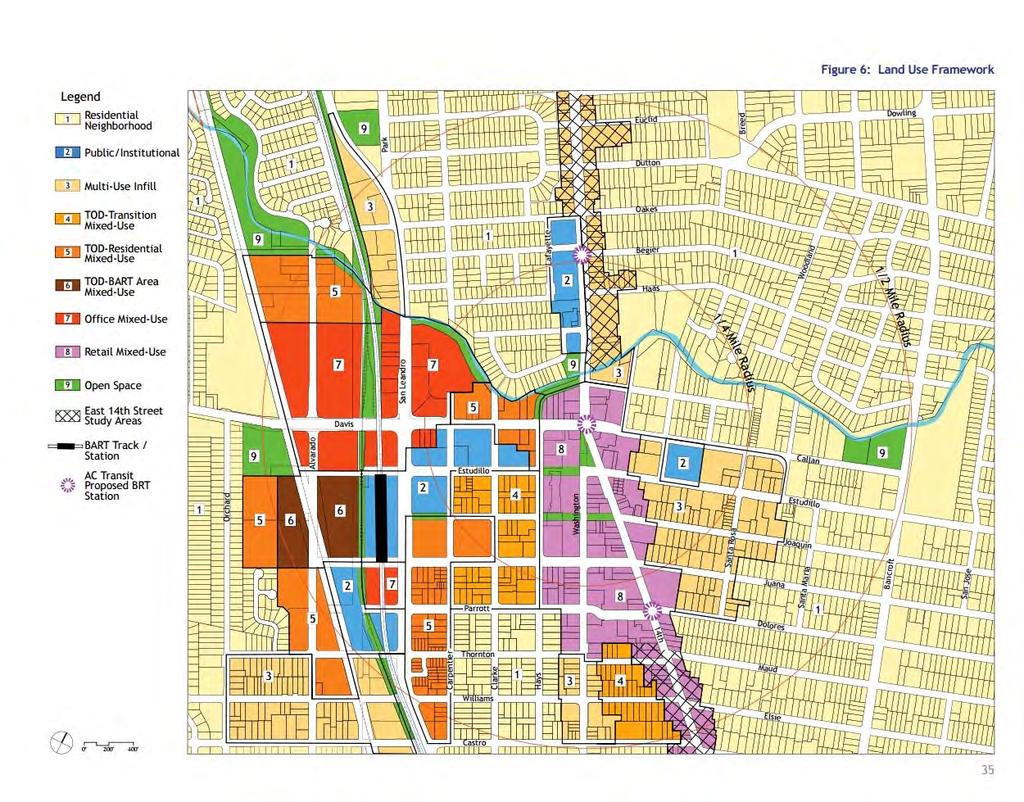
125

126


127 Downtown Area East Proposed Zoning Changes
128 From: Pat Devitt Date: June 9, 2016 at 9:53:20 AM PDT To: Subject: Apartments at corner of Bancroft and Estudillo I know the developer is trying to break leases that some businesses have in this building, but my real opposition to the building of apartments on that sight is the traffic it will produce. It is already a congested corner. Pat Devitt on San Jose St. Sent from my ipad
129 From: Galen Guilbert Sent: Friday, June 10, :34 PM To: _Council Subject: Zoning Changes in San Leandro Residential Neighborhoods Near Estudillo and Bancroft I do not support re-zoning proposals allowing a large number of residential dwellings added where office space currently exists near the intersection of Estudillo Avenue and Bancroft Avenue. City and school infrastructure are going to feel the effect of the Marea Alta complex and additional pressure is unwise. Traffic at this intersection is already congested and class sizes at our schools are too large. Please reject any rezoning of this neighborhood. Thanks Galen Guilbert 715 Dutton Avenue
130 From: On Behalf Of paris Sent: Friday, June 10, :12 PM To: _Council Subject: Proposed Zoning Changes Dear Council Members, In regards to the proposed changes to the city zoning plans, I wish to register my opposition. San Leandro has always been, primarily a residential, suburban city. It seems that with the changes proposed by the council you intend to remake San Leandro into a densely populated urban city. With the advent of the Marea Alta development, and proposed further development at the old CVS site and others, the characteristics of our city will be changed forever. More importantly, the lack of consideration for the existing residents in regards to traffic flows and noise abatement shows a complete disregard for your duties to the existing population in favor of the developers and a planned future population. I am hoping that those of us with the time will be able to attend the upcoming zoning discussions to express similar opinions in person. As for me, I hope this will encourage you to reconsider whatever benefits you believe the city will gain from this proposed unbridled growth. Ken Paris 1571 Graff Ave San Leandro, CA
131 From: Robert Caruso Sent: Sunday, June 12, :00 PM To: _Council; Battenberg, Cynthia; Liao, Thomas Cc: Faye Clements Subject: Subject: Proposed Zoning Changes in Master Plan / Meeting Last Thursday Night Dear Mayor, City Council, Cynthia and Tom: Faye (my wife, in copy) and I attended an EENA meeting last Thursday where the proposed zoning changes between the Estudillo Avenue fire station to Bancroft, and crossing over, were discussed. To follow up, we sent this to Deborah earlier which we also want to share with you. Thank you, in advance, for hearing the concerns of the community. Kind Regards, Robert Caruso and Faye Clements Forwarded Message From: Faye Clements <fayeclements@yahoo.com> To: "navab.bahar@gmail.com" <navab.bahar@gmail.com>; Deborah Cox <dcox@sanleandro.org> Cc: Robert Caruso <rcaruso510@gmail.com> Sent: Sunday, June 12, :41 PM Subject: Proposed Zoning Changes in Master Plan / Meeting Last Thursday Night Hi, Nahar, Deborah - Bahar, it was nice to meet you last Thursday night after hearing your name for a while, now. Thanks for your work for our community, and thanks for keeping us all informed of when you are next meeting with Deborah, Corina, and others about the proposed zoning changes. As you summarized at the meeting, we all definitely want to have input on the proposed zoning changes that were discussed.
132 I would also add to your summary of last Thursday's meeting that, of the people there, all had concerns about these zoning changes that are being proposed except for two people there, and perhaps only one (of the many that spoke). (To clarify: One liked, specifically, the proposed apartment complex; the other played devil's advocate.) Deborah, the overall tenor of the meeting is that development is good and necessary, and that we welcome development that is suited to the area and which the majority of residents agree upon. The majority in the room last Thursday, however, did not agree that these zoning changes would serve the neighborhood and community well, nor would Mr. Silva's development which is being discussed. There was an air of compromise, though. The concerns I heard ranged from the long-term risk of wholesale changing of zoning when variances can always be granted to deserving projects; to the nature of the changes proposed (allowing for 50 ft tall buildings in an area of predominantly one- and two-story buildings, and max 30 ft tall buildings) - and for such a large swath of parcels; to full mixed-use for 20(+?) parcels; to concern for ensuing traffic congestion and parking issues; to desire for affordable homes/condos to bring in more invested interest; to considering the concerned area DT (downtown), at all, given its location; to concern for how the City has arrived at these proposed changes and the reasons behind why this one, just-purchased parcel ( Bancroft) is included in these proposed zoning changes. Deborah, Robert and I cannot make the meeting this Thursday night; however, we are going to take our concerns to City Council-at-large, and Staff, too. In short, we share all of the concerns mentioned above and would add that any worthy, acceptable development can be approved as a variance to existing zoning while we carefully consider what the best zoning is for our community. We do not at all believe that what is being proposed is good for the community. Thanks for listening. - Faye
133 From: Carol Sent: Sunday, June 12, :20 PM To: _Council Subject: Zoning changes... June 12, 2016 Hello, Thank you to all city staff, City Council members and Planning Commissioners who work to improve our wonderful city. You are often the behind the scene voices to city issues and changes. Often times the public is not aware of what is going on/being proposed. It is our own faults as, I'm pretty sure, all information is public record and that meetings are open to the public. It is when an issue comes up that directly impacts our lives, living spaces, future - that one might stop, reflect and then say, "Wait a minute...hold on there!" The proposed change to the city of San Leandro zoning code to expand "downtown" San Leandro into residential neighborhoods - or rezone "P" (Professional Office District) zones to "DA-2" zones (Downtown Area 2) is one of those issues for me (and my husband). I was born in Oakland, lived my entire childhood and most of my adult life in San Leandro. I have lived at my current address for over twenty years. I love San Leandro. I love my house and our beautiful tree lined street! I live (with my husband) at 645 Joaquin Avenue. Our house is across the street from the recently sold office/medical building on Bancroft Avenue. If the rezoning is passed, that lot can (I understand) become a massive five story, 51 unit, apartment complex. I invite all people involved in this decision to come to our house and see how a huge complex will impact our living space (including our front patio, front and side front room windows, front door and front porch and walkway). I believe building a 51 unit apartment complex will negatively impact the parking situation in the area. Joaquin Avenue traffic will especially worsen. Evidence of worsened, more congested, traffic can be witnessed today at the start and end of the school day. I believe that the property values of the houses on Joaquin Avenue (and all residential housing near the proposed complex) will go down. I believe there will be a negative impact on the surrounding single family homes in this area - the feeling of openness and space will be lost to a huge structure! I am not opposed to change. Make the lot into a much smaller apartment complex; keeping the "P" zoning. Or build single family homes (which I believe home owners are more vested in the integrity of their city/community). I understand rent on a two bedroom, two bath apartment is proposed to be $4, a month. Really? I did some research on current San Leandro rentals and found: Out of 32 two bedroom rentals available in San Leandro - none are renting for $4, a month! The highest cost apartment is $3,697.00; two are asking $2,500.00; and the remaining 29 apartments are asking between $1, to $2, per month. Who is going to move to San Leandro with our limited arts, dining, shopping and pay $4, per
134 month? I don't think DA-2 is appropriate zoning for the area down Estudillo to Bancroft and the one property across Bancroft. I do not consider that area "Downtown" nor do I know anyone else who does. Downtown is downtown - not into residential neighborhoods. What is wrong with keeping the "P" zone? Don't neighborhoods need professional/office buildings? If the "P" zone down Estudillo is changed, and one by one buildings are changed to apartments, it will impact many of the citizens of San Leandro who walk to their dentist and doctors. Isn't the objective of the TOD plan to lessen residents' dependence on cars? Where will the displaced professionals relocate? How many new students are anticipated to be a part of this new residential growth? How will their increased numbers impact the crowding in our nearby schools? My knowledge on this matter is primarily a result of participation in a neighborhood meeting. I am a bit perplexed that nothing about the zoning change was brought to the attention of the neighborhoods impacted the most by proposed changes (I have not received any specific notice of this proposed change). Knowing what I do now, I request the zoning to remain as is. I understand the city can change zones on a parcel by parcel basis, while leaving the "P" zone in affect. But if you change to a DA-2 zone, and someone comes with plans to build a five story apartment complex, the city has to approve the plans. This is not good! Your consideration to NOT rezone to a DA-2 is appreciated. Sincerely, Carol and Paul Jewell 645 Joaquin Avenue San Leandro, CA 94577
135 From: Sonia C. Sent: Monday, June 13, :03 PM To: _Council Subject: ZONING CHANGES I am contacting you today in regards to a notice I received stating that the city of San Leandro is proposing to re-zone over 20 properties along Estudillo Avenue from the Estudillo Fire station to Bancroft Avenue to allow mixed-use apartment buildings. I currently live on Joaquin Avenue and I am OPPOSED to this!!!!! I have kids who attend McKinley Elementary, San Leandro High and Bancroft Middle School. School are already way overcrowded and having these apartment buildings will only make things worse. The ones who will suffer from this are the kids and teachers. There are apartment buildings down the street from my house and on the block over, which continues to bring in the wrong crowd of people. A lot of good citizens are moving out and bad ones are moving in. Raising the crime rates in the city. San Leandro is not what it used to be and is slowly turning into Oakland and putting apartment buildings will only make things worse for the residents of San Leandro, the schools, our kids and the congestion of traffic in these areas. NO TO THIS!!!!!!
136 From: "Leah via The BNA" Date: June 13, 2016 at 9:47:39 PM PDT To: "The BNA" Subject: Re: The BNA: Proposed zoning changes that impact North Area Reply-To: "Leah" Thanks to Stephen and Rose for calling this to our attention. I don't know about "Millennials" or care to all that much. I /do/ feel that San Leandro is auto-centric and needs to find a /way forward/ from that stance. Form-based planning codes have helped other communities such as ours establish an actionable and readily understood vision based upon community input. Upfront costs exist but in the long run saves $ and results in a built environment that exceeds expectations. Sincerely, -Leah Hall Sent from my ipad On Jun 13, 2016, at 6:31 PM, susan riskind via The BNA <thebna@listbox.com> wrote: I would like to second former mayor Stephen Cassidy's call for a public discussion on proposed zoning changes that would insert high density housing as tall as the downtown Wells Fargo building right next to 1 and 2 story homes in violation of both the community developed TOD and accepted planning practices. Our neighborhoods are small and narrow: do we want them surrounded by high walls or should we have transitional development that gradually increases in height and density as it approaches Downtown? Should areas such as the Dutton/Bancroft intersection be considered an extension of Downtown? What about parking requirements? Traffic impacts? It is naïve to believe that everyone will ride the bus and take BART. These are serious changes to our neighborhoods and we will live with them for a long time. We need a REAL community process to discuss these issues, not canned dog and pony shows that pretend they don't exist. Please contact the City Manager's office and ask them to delay these proposals until we can have a true informed voice in the future of our community. Thanks, Rose The BNA Archives Modify Your Subscription Unsubscribe Now The BNA Archives Modify Your Subscription Unsubscribe Now
137 From: Patricia Jeong Sent: Monday, June 13, :18 PM To: _Council Subject: Proposed zoning changes on Estudillo and Bancroft Ave. To the Honorable Mayor and City Council of San Leandro: We would like to share our concern over the proposed zoning changes in our neighborhood. We strongly oppose the construction of a 51-unit apartment complex at the corner of Estudillo and Bancroft Avenues. Possible consequences of such high density housing would negatively impact our quality of life in Estudillo Estates. We may see an increase in crime, traffic congestion, and over-crowding in our public schools. Please take into consideration our concerns as we have been residents in Estudillo Estates since 1980 and plan to stay in our neighborhood. Respectively yours, Dale M Jeong, DMD and Patricia Chin Jeong Joaquin Avenue
138 From: Sent: Monday, June 13, :44 PM To: _Council Subject: Proposed zoning changes To Council Members, Planning Commissioners and respective City Employees: As lifelong San Leandro residents and current homeowners, we are writing to express our concern and disapproval over recent proposals to re-zone properties within the area of the Fire Station on Estudillo Avenue to the professional building on the corner of Estudillo Avenue and Bancroft Avenue. We urge you to not rezone this area from a P to a DA-2 designation. A change to DA-2 is excessive and will negatively impact the current residents of San Leandro. We find problems with the housing density and building heights in the DA-2 designation. Additionally, we think this designation brings in excessive renters to our city who typically are not as vested in the well-being of the community as property owners. What are the service demands of this new development? How will this influx of people stress the capacities of our existing streets, utilities and public services? An increase in population density will contribute to even more congestion on our city streets, parking will become more difficult to secure not only in the immediate apartment unit area but also in our downtown shopping area (Safeway area). How many new students are calculated to be part of this new residential growth? How will their numbers impact the crowding in our nearby schools? Where are the existing Professionals and the services they provide going to relocate? A zoning change in this area from a P to a DA-2 designation does not preserve the character and quality of our existing neighborhoods and life in San Leandro. What are the benefits to the current residents of San Leandro? A change to DA-2 zoning for this area would be a benefit to a developer s profits at the expense of the current residents of this city. We urge you to not rezone this area from a P to a DA-2 designation. Sincerely, Len & Lynn Vahey 1645 Daniels Drive San Leandro, CA
139 Dear Mayor Cutter, City Council Members, Ms. Battenberg, Mr. Liao, and Mr. Breslin, My name is Jane Abelee. I have lived in San Leandro for 35 years, have raised my children here and have worked as a teacher and administrator in our schools. I am writing today with my concerns with regards to the proposed zoning changes property at 1300 and 1380 Bancroft Avenue. I attended a meeting of the EENA last week, where many of us expressed our concerns with this proposal. It is my understanding that the current owner of the property is planning a 5 story building, with approximately 50 apartments. A building like this would create additional traffic and parking concerns to an already congested area. A building this size, and density, is far more appropriate close to BART or downtown, not in a primarily single family, residential area. It is also my understanding that the owner is planning to construct 2 bedroom units and wants to price the apartments at an unrealistic peak rate of $4000/month in rent. What would be the plan for this property if the units do not rent at that rate? Another question: What was the process for the property owner to build this structure? According to my neighbors in the area, there was little if any notification or request for input from the community. When a project of this size, with the possible impact of changing a neighborhood is proposed, would it not be appropriate and expected to get community input? I strongly agree with Stephen Cassidy's suggestions that "If City staff's proposal for the re-zoning of 1300 and 1380 Bancroft Avenue (the now Silva property) was not approved, Silva could still seek to change the zoning for the property. He would have to (a) present an actual development plan (something he has not done - all we have are, in staff's words, "preliminary concepts"), (b) which would be reviewed by staff, then (c) presented to the Board of Zoning Adjustments (which consists of 7 San Leandrans appointed by the Mayor and City Council), (d) extensive notice to the community would be provided, (e) a public hearing on the matter would occur, and (f) if either party - Silva or the community - disagreed with the decision of the Board of Zoning Adjustments then they could take an appeal to the City Council, which (g) would review the appeal at a public meeting after taking public comments. " I am not opposed to all rezoning but I am opposed to changing this particular commercial property to one that allows for multiple units zoning. A smaller number of apartments (5-20), condos, single family homes or high end retail/ restaurant would positively add to the neighborhood. Hopefully, you read our Nextdoor Forum where many in the neighborhood have expressed the need for more restaurants in our city. Perhaps that is what the rezoning should be.
140 I am sorry but I will not be able to attend the meeting tonight, but I wanted to express my deep concerns over this proposed rezoning and the housing project. Thank you for your time and deep consideration for my and my neighbors concerns. Sincerely, Jane Abelee
141 From: Debra Blondheim Sent: Tuesday, June 14, :13 AM To: _Council Subject: Building Project at Estudillo and Bancroft As a 20 year resident of Estudillo Estates and neighbor of Bancroft Middle School I wish to register my no vote on the re-zoning and building project that will increase building height and lead to the further urbanization of the Estudillo approach to downtown. One of the reasons I purchased in San Leandro and Estudillo Estates in particular was because of its small town feel and appeal as a residential area. Too many homes have already been turned into businesses - real estate, dentist/doctors offices, etc. - along Estudillo. I would like to see that "business creep" halted. Such large scale apartment buildings (which need to provide at least 2 parking spaces per unit as a realistic requirement) are better suited closer to downtown and out of the residential areas. With the school and its own inadequate parking problems, we already have plenty of cars parking/picking up-dropping off without even more cars encroaching into this quiet and thus far peaceful neighborhood. I know with rental prices at record highs it is tempting to think of increasing apartment housing but that is why I left Oakland. I saw home after home pulled down for apartment buildings. Do not lose the cozy-child friendly neighborhood to quick cash and urban sprawl. Once it is gone you won t get it back. Just say no to this apartment project and the re-zoning of the area. Thank you, Debra Blondheim San Jose St.
142 Planning Commissioners, Planning Staff, and Honorable Stephen Cassidy: First, I apologize for missing this week s Planning Commission meeting. I had thought these General Plan reviews were to take place starting a few months ago. My comments below are for the record during this San Leandro General Plan proposed change review period. My comments at this time are specific to the TOD DA zone classifications, with some specific to the parcel former Mayor Cassidy has concerns with. Although I do support TOD developments, and TOD developments in current Professional Office P zoned areas, if I understand the proposed changes correctly, I would want some restrictions at the perimeters or limits of the new zones. Typically there are buffers, apartments or condos usually, acting as transition or buffer areas between commercial areas and single family (RS) properties. I would support TODs at the limits with restrictions if at the RS/TOD line TODs were required to have lower floor area ratios, have lower heights, have set-back requirements that are current or modified but not reduced to zero, and have more parking required than in proposed TOD zones. Also, at the limit or perimeters, I would not support the removal of the daylight plane requirement that protects single family home owners from being shadowed by tall developments; there are changes in language that state that this current requirement is confusing, but I don t agree. Regarding the Estudillo/Bancroft/Joaquin parcel referred to by former Mayor Cassidy in his letter to Planning Commissioners, the parcel was likely purchased with the intent to develop, with uncertainty as to whether the parcel would ultimately be approved as a TOD DA2 parcel, or approved as something different with restrictions. As currently proposed, I agree, the developer can maximize the development of the site. I think there is room for improvement at the site, with mixed use retail and housing, but the owner should not be tied or restricted to what was allowed in the past. We should be able to come up with a nicer acceptable development. I do like TODs and greater downtown housing densities. I think the increase in a younger spending population will attract the popular or more upscale food, retail, and entertainment that San Leandro residents often wonder why we cannot attract. I will likely have more comments regarding the remaining portions of the General Plan proposed changes when I return. Sincerely, Tony Breslin Planning Commissioner-District 1
143 From: luvs2labs Sent: Tuesday, June 14, :03 PM To: _Council Subject: NO! Bad Idea on zoning changes Please NO new apartmet buildings this area has enough congestion and traffic NO more renters to degrade/bring crime into the area. NO MORE STREET LITTER ETC ETC FROM renters (most) who have no respect for homes and community Lets NOT overcrowd.the schools more. NO ZONING CHANGES From: luvs2labs Sent: Tuesday, June 14, :09 PM To: _Council Subject: NO NEW ZONING Previous continued from still say NO tall apartment building I am on Collier Drive, neighbor of Oscar and Mylene, my name is Jennifer Moran This will continue to make San Leandro spiral down Sent via the Samsung GALAXY S 5, an AT&T 4G LTE smartphone
144 From: julie nicholas Sent: Tuesday, June 14, :35 PM To: _Council Subject: Zoning Changes I am unable to attend the June 16th City Council meeting as we will be out of town, but I would like to make my views heard about the proposed rezoning of 20 properties along Estudillo Avenue. I am definitely against changing the zoning to allow mix-use apartment buildings in that zone. The reasons are: 1. Would significantly increase traffic on Estudillo, which is already extremely crowded during commute time. 2. Parking would increase on adjacent streets, as there is no way enough parking would be allotted for the people in the apartments and for store use. Parents already have trouble finding places to safely park when dropping and picking up students. 3. More cars would increase possibility of Bancroft and SLHS students who walk to and from School along Bancroft to be involved in an accident.. 4. We have plenty of apartments, more than most towns in my opinion, so I don't see the need for more. All communities are feeling the pinch of housing, but increasing the density of people in San Leandro will bring more problems than solve them. 5. There are areas that would benefit from this type of development, down by Bayfair as an example. The proper placement of development is at issue here. Already the city council did not allow enough parking in the new CVS/Peet center, and neighbors are having trouble parking in their own neighborhood. As more businesses come in as planned, I am sure it will only get worse. Already I do not shop at Safeway on Washington as it is too difficult to get a parking space. A planned parking garage would have helped matters as Alameda put in, with free parking on Sunday, but this was not done. Also parking spaces around BART has decreased, resulting in people in adjacent neighborhoods not being able to park in their own neighborhood. I imagine the residents will have to request " Berkeley style street parking" with permits for residents to park in their own neighborhood. I know I will be speaking with my neighbors to learn what happens at the June 16th meeting, and the views of each council member. Sincerely, Julie Nicholas Resident of District 1
145 From: barbifever Sent: Tuesday, June 14, :06 AM To: _Council Cc: shcassidy Subject: San Leandro zoning changes Dear Mayor Cutter, San Leandro City Council and former Mayor Cassidy, I live in Estudillo Estates and I am strongly opposed to a new 51 unit, 47 - foot tall apartment building, at Bancroft Ave and Estudillo. This area is already so congested, with morning school traffic and with commuter traffic on Estudillo, going towards the 580 freeway. In the morning during the week, it is hard to turn on to Estudillo Ave from San Jose Street. Currently there is nearly the need for a 4 way stop. There is just not a feasible infrastructure there to sustain this type of apartment building. In San Leandro another poor planned zoning example is the new housing near BART. Quite frankly the zoning of the apartment building on the site of the old BART parking lot is a travesty. So many people scramble daily for parking now. Those parking places will never be recaptured, even with the parking lot under the apartment building. Parking there will now need to accommodate the new apartment building cars, the new business building across the street, and the BART commuters. My husband is a BART commuter and is now parking three blocks away from BART daily. Public transportation should be convenient for the public, not a hassle. We have lived in San Leandro for 27 years. San Leandro is a great community, but this new planning/ zoning situation is quite concerning. If zoning is not done correctly are sweet community will turn into a congested, densely populated stressful way of life. There are other areas where it would be more appropriate for a new apartment building, perhaps near the new Kaiser or closer towards the Marina area for instance. Thank you former Mayor Cassidy for your time in office and for your very helpful letters to the editor recently in the San Leandro times. Thank you, Vicky Radigue
146 From: Jill Singleton Sent: Tuesday, June 14, :25 AM To: _Council Subject: Zoning Changes on Estudillo/Bancroft -- PLEASE FIX THE INTERSECTION Dear Mayor/Council: I received a flyer on my porch from neighbors who apparently are opposed to a proposed zoning change that would permit a 51-unit apartment building at Estudillo and Bancroft. As a longtime homeowner in Estudillo Estates (since 1989), I have some concerns not about increasing density in the area, which I generally favor, but about the road configuration, especially if we are to be realistic about the pressures additional density will put on the existing infrastructure. If the zoning is changed and the project is approved, then I sincerely hope you fix the traffic problems at this intersection. Let me itemize them: 1) When Bancroft was reduced from four lanes to two, the city created traffic jams at this intersection. My understanding is that through a convoluted transportation funding process, the idea was to restripe for bike lanes and somehow reduce Green House Gases (GHG). It s time we evaluate and objectively measure the results before the city makes further commitments in this direction. 2) My observation, through daily travel, is that we have considerably longer wait times at the lights, with engines idling and this must result in a NET INCREASE IN GHGs. During the busy afternoon hours, I inevitably sit through two or three light changes before proceeding through this intersection. In the past, this NEVER happened. How is this considered a transportation, environmental, or quality of life improvement? I see absolutely zero benefit. 3) The right turn option from Northbound Bancroft to Eastbound Estudillo needs to be lengthened. Sitting in a two-block backup through several red lights and taking up pavement that is coveted by other Northbound drivers, seems to me to be a big waste of time, energy, patience All that is needed is a permissive restriping so I can turn right, go home, and shut off the engine. 4) Are we seeing a significant increase in cyclists? My observation is no. Do you have before/after counts? 5) Bicycle lanes may give cyclists a feeling of greater safety in sharing the roads with cars and trucks, but perhaps we could accommodate this another way.
147 6) The wait time to turn left from S/B Bancroft to E/B Estudillo frequently ties up the intersections at Callan/Bancroft due to the lack of pavement. 7) I am concerned about the safety of the Bancroft school children (and other pedestrians at the corners of Bancroft/Estudillo) given the tight intersection, limited line-of-sight, driving mistakes by parents dropping/picking up kids, etc. 8) I have seen large trucks make the turn at this intersection only with great difficulty. This is a safety concern as well as a traffic concern. 9) The left turn from Bancroft to Estudillo is tight (putting cars westbound on Estudillo in some jeopardy due to driver mistakes). If the intersection is not widened, then, at the very least, the limit lines should be addressed. 10) Finally, in recent years the City has reduced the capacity of its three north/south thoroughfares by about 50 percent through re-striping (San Leandro Boulevard, E. 14 th St. and Bancroft Avenue). I would like to see a thorough evaluation of the pros and cons of these changes, measuring the results against the objectives. It might also be beneficial to poll local residents on their attitudes toward the changes. Thank you for addressing these concerns as you consider making additional changes in this area. Jill Singleton 742 Rodney Drive
148 From: Sent: Tuesday, June 14, :12 PM To: _Council Subject: Proposed Zoning Changes / Estucroft Apartment Building? I am completely opposed to an apartment building being built at the "Estucroft" location. More specifically, I am opposed to any more housing being jammed into San Leandro without building more schools, first. Why are we not hearing of plans for more schools, but often hear of more dense housing? I feel that the very aspects of our town which make it pleasant are being eroded with development of this nature, potential rezoning for even taller buildings, guaranteed increased traffic, congestion, lack of parking. And definitely more crowding in our schools. Developers will profit, but the rest of us? It also concerns me that the meeting on Thursday coincides with the Warriors game, a source of local pride and excitement for so many. Maybe there should be another opportunity for neighbors to voice their opinions in person. Thank you, Judy Verhoek, a 32 year resident of Estudillo Estates.
149 From: Sent: Wednesday, June 15, :11 PM To: _Council Subject: Zoning Changes along Estudillo and Bancroft To the Mayor and City Council: As we cannot attend the meeting on the 16th we would like to submit comments for your review We agree with former Mayor Stephen Cassidy that we should be careful not to encroach against the established neighborhoods east of Bancroft, but we would like to see housing close to BART so people may walk there. We are concerned, however, with two things: 1, There should be enough parking for at least one car per unit as public transit does not get people to all places they need to go, and 2, Transit Hubs are a good idea until one realizes BART is overcrowded as it is and we are planning to worsen that situation by placing 7,000 more people close to an overcrowded BART system to overcrowd it more. We need to consider alternatives other than just BART for transport. We are not sure what that would be, but just are bringing that to the attention of City Hall at this point. That being said, we realize the need to build up as we just don't have the land for expansion in San Leandro to spread out. Thank you for your hard work Corey & Ute Anderson 1170 Oakes Boulevard San Leandro, CA
150 From: Stephen Cassidy Sent: Wednesday, June 15, :31 AM To: Mayor Cassidy Friends Cc: Phil Daly; Faye Clements; Robert Caruso; Ellen Corbett; _Council; 'Lynn Roman' via Board; Debbie Adams; Jane Abelee; John Forney; Mia; M Forney; Shelia Young; Sarah Bailey; Sarah Nash; Sarah Galvin; Morgan Mack- Rose; Katherine Vitz; Mike Katz-Lacabe; Margarita Lacabe Subject: Let's Not Shoot Ourselves in the Foot with New San Leandro Zoning Code Changes Dear Friends and Neighbors, To those that say wouldn't it be good if the City assisted in the creation of new, marketrate housing that would attract new residents and thereby generate demand for greater retail, shopping and dining options in San Leandro, my response is - yes, I agree. We can have this without bringing buildings of a use, density and height appropriate for Downtown San Leandro right up and into our residential neighborhoods on the northeast side of the city, Take a look at The maps show that city planners are seeking the re-zoning of multiple sites in the core of Downtown San Leandro - many of which are close to the BART station. That is fine with me. I support new housing in our downtown. In fact, there is one development in Downtown San Leandro well advanced in the planning process that will bring in 60 high-end apartment units within walking distance of BART. There are also vacant lots within eyesight of the BART tracks that would support dense, new housing. The City expects 15,000 new residents will live in San Leandro by 2040, with 7,000 of these new residents residing in Downtown of San Leandro. Source: Land Use section of New General Plan, page Let's make sure these new residents don't all need to have their own car to get to their jobs. The only way to do this, as set forth in the 2007 Transit Oriented Plan, is to channel new housing in Downtown San Leandro within walking distance of the BART station. We should not - as now proposed by city staff - redefine/expand the boundaries of Downtown San Leandro by eliminating the zoning of properties along Estudillo Avenue from the fire station to and across Bancroft Avenue as commercial and professional sites and re-zoning these properties as part of Downtown San Leandro.
151 We would be shooting ourselves in the foot if a large percentage of the 7,000 new residents the city is planning on living in Downtown San Leandro were actually located outside of Downtown San Leandro, beyond walking distance to BART, and thus had to rely on cars for commuting to work. This sounds absurd but it is entirely possible if the City Council adopts staff's recommendations on the re-zoning of properties along Estudillo Avenue. Unless we speak up and offer reasoned arguments based on the facts against what is being proposed - and not play upon fears or prejudice, I expect that the City Council will approve staff's proposal. If your concern is the "wrong" people will move into San Leandro, or other code words for racism, I categorically reject your viewpoint. Please move out of San Leandro. The San Leandro of 2016 is a diverse and tolerant community welcoming to all persons. This is the San Leandro I am raising my family in and the San Leandro I will fight to sustain and grow. This Thursday night, June 16th at 7 p.m., is our first opportunity to do so at a public meeting of the Planning Commission. The meeting will take place at City Hall in the City Council Chambers. The Planning Commission can make recommendations on the zoning code proposals to the City Council. The next meeting, however, is one that really counts - the City Council will be reviewing the proposed zoning code changes on July 5th at 7 p.m., again at City Hall. I wish that the City Council was not conducting such an important meeting on a date in which many are away on vacation. There is no reason why the meeting has to occur on July 5th and it is in the power of the Mayor and City Manager to change the date of the meeting. If you can't make the July 5th meeting, please share your views with the City Council by contacting them via at citycouncil@sanleandro.org Please feel free to share this message with others. Stephen Cassidy f: b:
152 From: Deborah and Kevin Cox Date: June 15, 2016 at 9:49:16 AM PDT To: "Cutter, Pauline" Subject: FYI Dropped off on my front porch.
153
154 From: Kendra Sent: Wednesday, June 15, :09 AM To: _Council Subject: Opposed to zoning changes Dear City Council member, As a 20-year Estudillo Estates resident, I am opposed to re-zoning that will allow up to 50ft tall unit apartments. The area of near Bancroft middle school will experience a huge traffic impact and add to an already over-crowded school. Parking will be very difficult for those in the area. Please do not allow this zoning change. Kendra Ferguson Barr 996 Bridge Rd San Leandro
155 From: Moira Fry Sent: Wednesday, June 15, :02 AM To: 'Mayor Cassidy Friends' Cc: 'Phil Daly'; 'Faye Clements'; 'Robert Caruso'; 'Ellen Corbett'; _Council; ''Lynn Roman' via Board'; 'Debbie Adams'; 'Jane Abelee'; 'John Forney'; 'Mia'; 'M Forney'; 'Shelia Young'; 'Sarah Bailey'; 'Sarah Nash'; 'Sarah Galvin'; 'Morgan Mack-Rose'; 'Katherine Vitz'; 'Mike Katz-Lacabe'; 'Margarita Lacabe' Subject: RE: [Former Mayor Cassidy] Let's Not Shoot Ourselves in the Foot with New San Leandro Zoning Code Changes From the meeting I attended last night, I heard nothing specific about this proposed project. I did hear about proposed zoning changes throughout the City. Please do not misunderstand me I am not in favor of building a 50 ft. high density up to the sidewalk apt building on Bancroft and Estudillo. But, I do want to hear: 1) why the zoning changes throughout the City are being proposed (and that was pretty fairly covered last night albeit in zoning jargon which takes a while to understand). 2) I want to hear from Mr. Silva what he wants to do at the Bancroft property I have heard and read assumptions about his intent but he was at last night s meeting and invited all in attendance and any who are interested in what he wants to do to be on site behind 1380 Bancroft Ave. (the southern building in the parking lot) at 3:30 on Friday 6/17 to at least hear him and include him in this discussion. 3) One of our neighbors who will not be able to attend on Friday also gave an impassioned talk to the group about not losing the focus and charm of San Leandro while allowing it to grow and retain the assets which made it a place we all want to live in. He also mentioned specific concerns about safety and security if high density housing is placed in Estudillo Estates. 4) Another neighbor gave a very clear and rational statement about respecting those who currently live in the City and specifically Estudillo Estates and making sure the City is not making decisions by drawing lines on maps but by listening to and respecting the input from those living here. HE also expressed concern that the buffer between the downtown and residential area be maintained. 5) The City Staff was polite, took notes and were clear that this was the first of many meetings to be held. No decision is to be made until September. I believe there is time to examine all sides of the issue and still have all of our voices heard. This is not changing tomorrow night nor on July 5. But, both are chances to learn more and to end up with something we can all either be proud of or simply live with but it is important that everyone take the time to learn and understand what is being proposed and why. The City s website is full of information best digested a bit at
156 a time but contacting the City Staff with your questions as well as your area Planning Commissioner and City Council member for answers will go a long way to helping all of us understand what it takes to move the City forward to into well past the time I may well even be alive. But, I want this City to thrive and be viable for my child and his children too. Moira Fry 781 Bridge Rd. From: mayor-cassidy-friends@googlegroups.com [mailto:mayor-cassidyfriends@googlegroups.com] On Behalf Of Stephen Cassidy Sent: Wednesday, June 15, :31 AM To: Mayor Cassidy Friends <mayor-cassidy-friends@googlegroups.com> Cc: Phil Daly <pg.daly@sbcglobal.net>; Faye Clements <fayeclements@yahoo.com>; Robert Caruso <rcaruso510@gmail.com>; Ellen Corbett <corbett4senate06@yahoo.com>; <CityCouncil@sanleandro.org> <CityCouncil@sanleandro.org>; 'Lynn Roman' via Board <board@estudilloestates.org>; rsmith0000@live.com; jim@rjholtom.com; Debbie Adams <adams.debbie@gmail.com>; whoareu17@aol.com; susanjensenyoung@yahoo.com; Jane Abelee <jaabelee@gmail.com>; John Forney <jforney941@gmail.com>; newedhome@comcast.net; Mia <president@thebna.org>; M Forney <mforney2870@outlook.com>; Shelia Young <mayoryoung@yahoo.com>; Sarah Bailey <smbailey57@gmail.com>; Sarah Nash <snashmail@comcast.net>; Sarah Galvin <sarah@sarahgalvin.com>; Morgan Mack-Rose <mmackrose@gmail.com>; Katherine Vitz <kvitz@yahoo.com>; Mike Katz-Lacabe <mkatz@mikesbytes.com>; Margarita Lacabe <margalacabe@gmail.com> Subject: [Former Mayor Cassidy] Let's Not Shoot Ourselves in the Foot with New San Leandro Zoning Code Changes Dear Friends and Neighbors, To those that say wouldn't it be good if the City assisted in the creation of new, marketrate housing that would attract new residents and thereby generate demand for greater retail, shopping and dining options in San Leandro, my response is - yes, I agree. We can have this without bringing buildings of a use, density and height appropriate for Downtown San Leandro right up and into our residential neighborhoods on the northeast side of the city, Take a look at The maps show that city planners are seeking the re-zoning of multiple sites in the core of Downtown San Leandro - many of which are close to the BART station.
157 That is fine with me. I support new housing in our downtown. In fact, there is one development in Downtown San Leandro well advanced in the planning process that will bring in 60 high-end apartment units within walking distance of BART. There are also vacant lots within eyesight of the BART tracks that would support dense, new housing. The City expects 15,000 new residents will live in San Leandro by 2040, with 7,000 of these new residents residing in Downtown of San Leandro. Source: Land Use section of New General Plan, page Let's make sure these new residents don't all need to have their own car to get to their jobs. The only way to do this, as set forth in the 2007 Transit Oriented Plan, is to channel new housing in Downtown San Leandro within walking distance of the BART station. We should not - as now proposed by city staff - redefine/expand the boundaries of Downtown San Leandro by eliminating the zoning of properties along Estudillo Avenue from the fire station to and across Bancroft Avenue as commercial and professional sites and re-zoning these properties as part of Downtown San Leandro. We would be shooting ourselves in the foot if a large percentage of the 7,000 new residents the city is planning on living in Downtown San Leandro were actually located outside of Downtown San Leandro, beyond walking distance to BART, and thus had to rely on cars for commuting to work. This sounds absurd but it is entirely possible if the City Council adopts staff's recommendations on the re-zoning of properties along Estudillo Avenue. Unless we speak up and offer reasoned arguments based on the facts against what is being proposed - and not play upon fears or prejudice, I expect that the City Council will approve staff's proposal. If your concern is the "wrong" people will move into San Leandro, or other code words for racism, I categorically reject your viewpoint. Please move out of San Leandro. The San Leandro of 2016 is a diverse and tolerant community welcoming to all persons. This is the San Leandro I am raising my family in and the San Leandro I will fight to sustain and grow. This Thursday night, June 16th at 7 p.m., is our first opportunity to do so at a public meeting of the Planning Commission. The meeting will take place at City Hall in the City Council Chambers. The Planning Commission can make recommendations on the zoning code proposals to the City Council. The next meeting, however, is one that really counts - the City Council will be reviewing the proposed zoning code changes on July 5th at 7 p.m., again at City Hall. I wish that the City Council was not conducting such an important meeting on a date in which
158 many are away on vacation. There is no reason why the meeting has to occur on July 5th and it is in the power of the Mayor and City Manager to change the date of the meeting. If you can't make the July 5th meeting, please share your views with the City Council by contacting them via at Please feel free to share this message with others. Stephen Cassidy f: b: -- If you wish to contact me, please me at --- You received this message because you are subscribed to the Google Groups "Mayor Cassidy Friends" group. To unsubscribe from this group and stop receiving s from it, send an to For more options, visit
159 From: Dave & Susie Jorgensen Sent: Wednesday, June 15, :59 PM To: _Council Subject: Bad zoning Changes Please stay with the TOD. We need a buffer zone between the high density downtown and the residential. For example Estudillo zoning should remain as its. No 51 unit apartment across from Bancroft Middle school, where 2 of our grand sons attended TOD makes sense don t mess with it. Regards, David Jorgensen 974 Arbor Drive San Leandro Ca
160 From: Lisa Kenny Sent: Wednesday, June 15, :08 PM To: Barros, Sally Subject: Downtown Zoning Changes in San Leandro Hi Sally, Thanks again for all of the information that you provided at last night's meeting. I am super excited for all of the upcoming changes in San Leandro. It is so fantastic to see all of the many positive and forward thinking ideas and plans coming into fruition. The proposed zoning change to my home is welcomed news, and I fully support it. I also fully support the other zoning changes that were discussed in last night's meeting - as I believe that they will greatly open up the possibilities and opportunities to residents, visitors, and business owners. Also, it would be great to hear in future meetings about how the fiber optic internet loop comes into play. As a San Leandro resident, it brings me great joy to see that there are so many wonderful people working on these improvement projects. I can't wait to see the San Leandro of the future. Thanks again, and I look forward to hearing more as this progresses. Lisa Kenny
161 From: Smallman, Alex Sent: Wednesday, June 15, :28 PM To: _Council Subject: Re zoning at Bancroft & Estidullio is a bad idea This road is currently one of the attractive streets leading to the downtown. It is a busy intersection now, with 47 housing units it will be a true bottle neck of traffic. When was this zoning first brought up? I saw an article in the Daily Review 2 weeks ago. We walked by this weekend and half the companys names are removed? We have two wonderful properties that are or will soon be available for reuse. The former CVS is empty and is a bigger lot and closer to BART than Estudillo. Also Kraft is closing and that is a tremendously large location that will need attention. In closing, Estudillo is a bad location to rezone, and there are better locations to use Alex Smallman Senior Customer Service Representative Dublin Blvd Dublin, CA Office (925) Fax (925) alex.smallman@graybar.com - Works to Your Advantage

162 San Leandro City Manager Chris Zapata 133 an 1380 Bancroft Re: Property Bancroft Ave, San Leandro Dear Mr. Zapata, EMERALD PROPERTIES I understand that the owners of the above property have submitted a request for rezoning. Given the high cost of developing apartments or condos today and the great need to provide more housing I strongly believe that we should encourage higher density zoning wherever possible. I have owned and operated apartment complexes in San Leandro for many years. Those properties are located in similar neighborhoods to the subject property and they are similar in design parking garage underneath and 3 floors of residential overhead. One such building is in the same neighborhood as the subject just off Bancroft Ave at 474 Dolores Ave. That building consists of 33 apartments 15 two bedroom two baths and 18 one bedroom units. There are 35 parking spaces. I have operated this building for over 20 years and I have never received a parking or traffic complaint from neighbors. Please consider the critical need for more housing in our city. Making more apartments available, particularly in this general downtown region, will be beneficial to our tenant population providing more choices, more affordability, etc. Sincerely, John Sullivan
163 From: carol thornberry Sent: Wednesday, June 15, :02 PM To: Cutter, Pauline; Cox, Deborah; Battenberg, Cynthia; Liao, Thomas; Lopez, Corina Subject: Proposed Changes to San Leandro Zoning Code Dear Mayor Cutter, City Council Members, Ms. Battenberg, Mr. Liao, and Mr. Breslin, My name is Carol Thornberry. I am writing because I am concerned resident, who is against the proposed rezoning of the property along Estudillo Avenue between Bancroft and E14th Street, including 1300 and 1380 Bancroft Avenue. My understanding about this project is: * A developer recently purchased a parcel at 1300 and 1380 Bancroft Ave. * When purchased this parcel was zoned P (Professional Building ). * Now this developer wants to rezone the property to DA2 (Downtown Area2). Although the site is currently zoned and was zoned at the time of the developers purchase exclusively for office space, the developer still bought the property with intention to demolish the existing buildings and replace them with a 47-foot tall, mixeduse 51-unit apartment complex. * In 2007, a TOD Plan created a buffer of lower density professional, commercial and multi-unit housing between downtown San Leandro and the residential neighborhoods on the northeast side of the city. * Despite this, the Planning Commission and the City Council are considering approving the rezoning change which will do away with the buffer and will violate the City's Transit Oriented Development Plan which calls for future residential growth to be channeled into the core of Downtown San Leandro near the BART station. * Up to date, according to city staff, the developer has not provided a development plan, only preliminary concepts. * Proper notice has not been given to the public, which to anyone who is paying attention, looks like a "bums rush" to push this rezoning through without public input. Some questions that come to my mind when I think of adding hundreds of people to a very small area of this city are: What is the developers plan for parking, for traffic, and for our overcrowded, under budgeted, lackluster test scoring schools. I think a decision to go forward with this rezoning without appropriate development plans, proper notice and due diligence would be irresponsible on the part of Mayor Cutter, the San Leandro City Council and the San Leandro Planning Commission; and extremely detrimental to the residents of San Leandro. I would hope that you, as this community's civil servants will listen to the residents of San Leandro who will be affected by your hasty decisions.
164 Thank you. Carol Thornberry "People are always blaming their circumstances for what they are. I don't believe in circumstances. The people who get on in this world are the people who get up and look for the circumstances they want, and, if they can't find them, make them." George Bernard Shaw Real Estate ebroker The Thornberry Team (510) Carol Thornberry - BRE# Stacey Thornberry-Martin - BRE#
165 From: Richard's Sent: Thursday, June 16, :58 AM To: _Council Subject: Large apartment building at corner of Estudillo and Bancroft Hello City Council, This is an to express my concern re: the redevelopment of a very busy corner (Estudillo and Bancroft) in my neighborhood. First of all, I am surprised that such a project is being planned across the street from a school. Have you ever been caught in traffic when school lets out on that corner? It is frustrating and not safe at times. People park all over the place; double park, make illegal u-turns, and children, being children don't always obey the traffic lights. It just doesn't make good sense especially regarding safety for the children. I am also opposed to such a tall and large building in this neighborhood. This is a nice family neighborhood with few large apartment buildings that I believe ruin the charm and small town atmosphere we enjoy in our area. I am not a NIMBY type of person and I do understand the housing crisis that exist in the Bay Area but this is just not the appropriate location for this project. In my opinion, this type of housing project should be built closer to the downtown area and Bart where there are taller buildings and better access to Bart. I will be attending the meeting scheduled for June 16th at 7:00 PM in the C. C. Chambers. Sincerely, Richard Aguirre Resident of Estudillo Estates Sent from my ipad
166 From: Nancy Alpay Sent: Thursday, June 16, :38 PM To: _Council Cc: Paul Bracke Subject: We Oppose Proposed Zoning Changes in San Leandro Dear San Leandro City Council Members, Unfortunately, my husband Paul Bracke and I are unable to attend the City Council meeting tonight. However, we would like to ensure that you know that we strongly oppose the proposed changes to the city zoning plan. As residents, we fully support the City of San Leandro and this fine community. However, this proposed change to the zoning plan makes no sense. High density housing should be situated within waking distance to public transportation. Traffic congestion is already a significant problem in the entire Bay Area. Allowing high density housing beyond the downtown area and not near BART would only contribute to this problem. We are not opposed to growth (manufacturing, business, residential) and would like to see improvements in San Leandro. However, this proposed zoning change appears to favor a developer without consideration for the impact on our community. We agree with a Nextdoor post by former Mayor Cassidy and appreciate his leadership on this issue: (excerpt from his post) "We should not - as now proposed by city staff - redefine/expand the boundaries of Downtown San Leandro by eliminating the zoning of properties along Estudillo Avenue from the fire station to and across Bancroft Avenue as commercial and professional sites and re-zoning these properties as part of Downtown San Leandro. We would be shooting ourselves in the foot if a large percentage of the 7,000 new residents the city is planning on living in Downtown San Leandro were actually located outside of Downtown San Leandro, beyond walking distance to BART, and thus had to rely on cars for commuting to work. Also, we strongly object to the incredible insulting and biased article in the San Leandro Times. Pathetic. We respectfully request that the City Council not approve these proposed changes to the zoning plan. Regards,
167 Nancy Alpay and Paul Bracke Bay-O-Vista San Leandro
168 From: richard dahllof Sent: Thursday, June 16, :26 PM To: _Council Subject: Zoning Changes at Bancroft Professional Center We strongly oppose the proposed zoning changes at above location for reasons that should be obvious to all. (traffic congestion, parking, school pick-up &drop-off etc. etc.) Kristine and Richard Dahllof 673 Joaquin Ave. San Leandro
169 From: Date: June 16, 2016 at 9:40:06 AM PDT To: Cc: Subject: re-zoning Estudillo/Bancroft Dear Mr. Zapata, I was recently made aware of planned re-zoning of certain areas of town to accommodate high-density apartment buildings. An article in the SL Times today also outlined a few issues regarding these plans. (I thought the article to be heavily biased in favor of Tom Silva, a millionaire landlord who will make a killing from this deal. The article ironically enough accuses the "wealthy neighborhood protests" of simply NIMBY). In reality, it is Mr. Silva who is the wealthy landlord who has lobbied to change the zoning so that he can make a windfall at taxpayer and resident expense. Since Mr. Silva sits on the rent review board and owns several other rental properties, it seems he has disproportionate influence over this issue, perhaps a type of conflict of interest is involved here. Please reconsider the locations of the re-zoning: Bancroft and Estudillo is not suitable to this sort of high-rise apt. buildings, they should be located closer to downtown and closer to BART. There are several other areas of town that are more suitable. Rezoning the area to cater to the wishes and greed of a wealthy landlord reflects just the sort of elitism and cronyism that many Americans are angry about. Using public law and infrastructure to subsidize the wealth of someone who is already wealthy is perfectly legal: yet many consider it a form of institutionalized corruption. The entire neighborhood and city should not have to suffer the increased traffic, parking problems etc. just to subsidize the profits of a wealthy individual. The public has been told that money is free speech by the Citizens United case, but do we have to demonstrate that in our city? If Silva gets his way, it will be a public demonstration of just that and a slap in the face of residents and taxpayers. Sincerely, Jon Foster Oakes Boulevard
170 From: Catha Howard Sent: Thursday, June 16, :40 PM To: _Council Subject: Proposed Zoning Changes To Whom It May Concern: After more than 20 years as a homeowner in San Leandro I have put down roots here, and I don't want to leave. However, the direction the city is going in has me worried. The proposed apartment complex at the corner of Estudillo and Bancroft Avenues will seriously impact the quality of life for residents of the North Area. Traffic has already increased a lot in the last few years, and with a multi-unit building at that intersection we will have gridlock every day. The area is too far from the BART station for most people to walk, and parking close to BART is almost non-existing anyway, so everybody will be commuting in their own cars. In today's San Leandro Times the North Area is referred to as a wealthy area, and it is implied that it is due to NIMBY-ism that so many of us are against the proposed development. There are a lot of retired people living on a fixed income in this neighborhood, and it seems to me that most of my neighbors are middle class, not wealthy. Most of us welcome people of all ethnic backgrounds when they move to our neighborhood. My husband and I bought a house here because it is a beautiful, relatively quiet residential neighborhood, but dealing with a huge increase in traffic will change the neighborhood completely. Your sincerely, Catharina Howard Begier Avenue
171 Subject: Proposed Zoning Changes Date: Thu, 16 Jun :33: From: Terry Kirby To: CC: Cutter, Pauline Cox, Deborah Chris/Pauline/Deborah/Cythia Please take note of the fact I, and a number of my neighbors and Homeowners here in San Leandro are concerned that the proposed zoning changes being considered are overly zealous in the pursuit of more high density, high rise rental housing, too far from mass transit, and too close to single family neighborhoods. I urge you reduce the number, scale, and height of these projects, so as not to overly populate and congest our city to the detriment of those who have chosen to purchase homes and live here. Let's not measure the success of the SL Development Department solely by the number of units/people that can be squeezed into our neighbors. Please consider the wishes of the residents and taxpayers whom you serve, who are urging a more moderate development plan for San Leandro. Thank you. Terry & Lynn Kirby and Others San Leandro Homowners
172 From: Debbie Martin Sent: Thursday, June 16, :41 PM To: Barros, Sally Subject: Timing for Zoning Change Work Sessions Ms. Barros - As I am sure that you have heard from my neighbors, these "work sessions" are poorly timed. Hopefully you can at least change the July 5th meeting. I care greatly about my neighborhood, but I admit that I am also a Warriors fan. They are our team and it is nice to have something that communities can come together and support. The July 5th meeting is poorly planned since that is the first day after the long July 4th holiday weekend, therefore making it impossible for concerned members of the community to attend. People have made holiday plans long ago and I am sure that the date can be changed. Please do that. I have a lot more on my mind about the ridiculous "proposed" plan for the corner of Estudillo and Bancroft which I will be sharing with many of the city employees very soon. Thank you very much for your attention to this matter. - Debbie Martin (20-year resident) 1151 San Jose St. San Leandro, CA debbiemartin99me.com
173 From: P MARTIN [mailto:dogzoe@hotmail.com] Sent: Thursday, June 16, :46 PM To: _Council Subject: Opposed to proposed changes to city zoning Dear Council Members, I am sorry not to be at City Hall tonight, but the Warriors are playing! In regards to the proposed changes to the city zoning plans, I wish to register my opposition. San Leandro has always been, primarily a residential, suburban city. It seems that with the changes proposed by the council you intend to remake San Leandro into a densely populated urban city, farther and farther away from BART. With the advent of the Marea Alta development, and proposed further development at the old CVS site and others, the characteristics of our city will be changed forever. More importantly, the lack of consideration for the existing residents in regards to traffic flows, influx to schools and noise abatement shows a complete disregard for your duties to the existing population in favor of the developers and a planned future population. I am hoping that those of us with the time will be able to attend the upcoming zoning discussions to express similar opinions in person. As for me, I hope this will encourage you to reconsider whatever benefits you believe the city will gain from this proposed unbridled growth. Very truly yours, Patricia Martin
174
175
176

177 June 16, 2016 To: Re: The Honorable Members of the San Leandro City Council and Planning Commission San Leandro General Plan Update Westlake Urban is appreciative of the City of San Leandro s leadership in advancing San Leandro 2035, the General Plan update. We would like to compliment the City staff on their efforts to create a document that provides policy direction for guiding the city s development in the 21 st century. As long-term stakeholders via our investments in the San Leandro Tech Campus, we have been particularly encouraged by the City Council's authorization of a new Economic Development element of the General Plan. As part of the review of the proposed changes to General Plan and Zoning Code, we have recently become aware of concerns regarding housing polices in certain locations in the community including Estudillo Avenue. As owners and developers of the San Leandro Tech campus, we are in discussions with a number of potential businesses interested in moving to San Leandro. As a result, we have become keenly aware of the Bay Area s housing crisis and specifically, how important housing is for the attraction of new employers to SLTC. We would therefore ask that the City Council and Planning Commission look at every opportunity within the community to increase the supply of housing especially housing within a mile of the BART station. Further, housing sites that are one acre or more in size are scarce and critical to the supply of multi-family housing. Therefore, we would respectfully ask that the City Council and Planning Commission carefully evaluate every site that is suitable for housing and take actions that could result in the creation of housing as soon as possible. Sincerely, Gaye C. Quinn Managing Director Westlake Urban, LLC Westlake Urban, LLC main 520 S. El Camino Real, 9th Floor fax San Mateo, CA westlakeurban.com
178 From: Sent: Thursday, June 16, :13 PM To: _Council Subject: San Leandro zoning Hi my name is Javier Ramirez and I live at 794 Dowling Blvd. I also oppose to the new changes to the zoning from San leandro. I cannot attend the meeting but hopefully my will count. Thanks Sent from XFINITY Connect Mobile App
179 From: Diane Rinella Sent: Thursday, June 16, :52 AM To: _Council Cc: Subject: San Leandro has misplaced priorities Dear San Leandro City Council, Screeching tires outside my window just now, as I look to a notice of a meeting for a project destined to increase traffic and decrease safety in front of my home. No, not just in front on my home, but also in front of a middle school, where kids already don t pay attention before crossing the street. And also in front of a preschool the one my kid goes to the one I drive her to, despite living only two blocks away, because crossing the street is too dangerous. I work from home in a room facing Estudillo. All day long, cars race by, tires screech, and horns wail. Getting out of my driveway is a dangerous task, so much so that I have contacted the San Leandro Police Department multiple times, requesting police presence. My husband recently attended a city meeting where traffic of East 14th was addressed. But what about Estudillo? Now, the city is threatening to make matters worse through an apartment complex, right across from the middle school, right across from a preschool, and down the street from a high school. Kids are everywhere in this neighborhood. As an adult, I don t like crossing the intersection of Estudillo and Bancroft. I m already planning that I will have to drive my daughter to middle school years from now. Now you want to make it worse. I bought my home with zoning in mind. (Yes, I really did. Most people don t, but as someone who has successfully petitioned the county to rezone the Lorenzo Theater as the county s first HP District, my mind has been rewired to think in the long, broad term.) I know how a zoning change can make or break an area. Right now, you are looking to rezone, and thus increase traffic, and potentially crime, in the heart of where I live where my three year old lives where kids step into the street, all day long. Every day, backing my car out of my driveway is hazardous. Speeding cars refuse to
180 yield to a resident simply trying to go about her life. Instead, regardless of their distance, once I am seen, drivers tend to speed to get past. Heaven forbid they continue at the same rate and find themselves behind another car, even if it does not slow them down. I have even had drivers lay on their horns from halfway down the block to warm me to move fast. Last time, I stopped and gave the person a lecture on keeping the child in my backseat safe. Now you are telling me this will become a daily occurrence. Drivers here don t care who they endanger. The city needs to address the problem, not amplify it. Please, do not rezone. Please, do not allow more traffic. Instead, I beg you to focus your efforts on a safer community. I should not fear crossing the street, and neither should our children. How about more traffic lights? Or a stronger police presence? If you can afford to rezone, you can afford to focus your priorities on a better, safer community instead. Sincerely, Diane Rinella Owner, 857 Estudillo Ave (510)
181 From: Tom Santilena Sent: Thursday, June 16, :32 AM To: _Council Subject: Zoning Change planned This is a terrible plan. It will be an eye sore detracting from the neighborhood. It offers huge traffic problems. It causes safety problems on an already safety problem for the school. The intersection is already so busy with children going to and especially when school is over in the afternoon. There already are so many children there, at that time, that it would be unsafe and it would cause difficultly for parents to pick up there children. This is a very bad idea. It will stick out like a sore thumb. It will stand out like a wart and lowers the value of the residential community which is coveted by home buyers who love the quiet quaint community. It sounds like just another greedy attempt to make profit for the developers and taxes for the city coffers. Please do not do this.. it opens up a precedence for other bad problems in the future.. We will look like just every other neighborhood in greedy little towns that cater to greed and profit. Are we now becoming a "FOR PROFIT CITY"? Lets hold out for principle and safety. Respectfully submitted, A VERY CONCERNED AND ANGRY CITIZEN.
182 Dear Tom, Per our conversation, please share or forward this with the Planning Commission members. As a business owner and Automobile Dealer in San Leandro, I am extremely concerned about the Industrial Transition - Marina Blvd. East. proposed Zoning change. By changing much of the North of Marina Blvd. properties to IT will have devastating consequences to Automobile Industry in San Leandro. The City of San Leandro invested tremendous resources to secure, promote and build Marina Blvd. as "AutoRow". Due to the City's foresight and hard work of our San Leandro Dealers, Marina Blvd. has became one of the most successful Automotive destination. With that success, we need the ability to expand our operation. The change of zoning of "only" viable locations for Automobile Dealers, to IT, will force us to compete for with residential development for the property, which is cost prohibitive. I appreciate the need for the residential development, but I believe there are plenty of other locations in San Leandro which are more beneficial without sacrificing the Automotive Industry. Furthermore, the limited area in the proposed zoning on Marina does not and will not provide sufficient depth or acreage to operate an Automobile Dealership, essentially making Marina Blvd. unusable as Automotive use. I proposed that the proposed zoning change be moved back minimum of 1 block, preferably 2 blocks north to align with Harlan Street or Castro Street. Automobile Industry is the number one economic driver for City of San Leandro, we contribute most tax revenue to the City, employee hundreds of employees and bring ten's of thousands of customers per month to San Leandro from outside the City, who not only spend money at our dealerships but at downtown and other businesses in San Leandro. The change of zoning will have lasting effects in our industry and City of San Leandro for many years and decades. I implore you to consider the consequences of the proposed changes to the Zoning, Automotive Industry and City of San Leandro.
183 Thank you for your time and I can be reached at (direct) or steve.song@fhdailey.com for further discussion. Have a Wonderful Day! Steve Song President F H Dailey Chevrolet Novato Chevrolet Please note the new address Steve.Song@FHDailey.com
184 From: Leila Bulling Towne Sent: Thursday, June 16, :25 PM To: _Council Subject: Estudillo & Bancroft Zoning Changes Dear City Council Members and Mayor Cutter, My husband and I wish to express our concerns to you regarding the proposed rezoning/development on Bancroft Avenue across from Bancroft Junior High School. We live nearby on Begier Avenue and have owned our house there since Prior to that we lived on Elsie Ave for several years, so we have familiarity with the pedestrian and vehicle traffic as well as general activity in that area. Our concerns center on a few points: -Traffic: it would be very helpful for city planners (and possibly Councilmembers and Planning Commissioners) to observe the traffic chaos that occurs during drop off and pick up times for Bancroft Junior High; it is very hard to imagine how the addition of yet more cars to that intersection would play out. The number of units being contemplated suggests 50 to 100+ additional vehicles in that area. For illustration, moving through that intersection can take up to 10 minutes during school. -Parking: again, this potential development would conservatively bring additional vehicles to that location. Where will residents park? Currently, there is not enough parking for school employees and for parents dropping off and picking up children, not to mention for Memorial Park. Will there be multiple levels of underground parking to accommodate this number of vehicles? Street parking around that area is extremely limited. We don't believe it would be realistic to expect or assume that residents will park several blocks away. -Egress: again, due to the high number of vehicles routinely in that area, we do not feel planners are properly considering how difficult it will be for cars to enter and exit the imagined complex. Only right turns onto Callan and onto Bancroft would be legal (presumably) yet, realistically, many people will not choose to drive around the block to head West towards downtown San Leandro. Will police be there regularly to enforce traffic laws and prevent illegal left turns and protect school-related and other pedestrian traffic? Traffic enforcement is rarely, if ever, conducted there now. -Services: the North area currently lacks adequate shopping and retail; the addition of more housing units will only exacerbate that shortcoming. We love the neighborhood feel of our streets. We are homeowners who have chosen to create lives here in San Leandro for the long term. We would like the city to respect our desire to continue to live in a part of the Bay Area that provides a small-town feel and
185 promotes well-considered development that enhances "qaulity of life" for both existing and potential residents. Re-zoning and developing this site in the way proposed does not seem consistent with that goal. Thank you for reading and for your consideration. Leila, Will, Liam, and Nora Towne
186 From: Leona Wong Sent: Thursday, June 16, :43 PM To: _Council Subject: Zoning changes - I do not approve San Leandro City Council, I reside and am the owner at 661 Joaquin Ave. in San Leandro. I was not available to attend tonight's meeting, however would like to comment that I do not approve of the request for zoning changes on the corner of Estudillo and Bancroft. Currently, the corner of Bancroft/Estudillo as well as Joaquin/Bancroft has very heavy traffic. The proposal to build the 51 unit structure will cause additional traffic and congestion on bother corners which I am NOT in favor of. Please consider safety first for the kids at Bancroft Middle school instead of additional income for the city of San Leandro. Sincerely, Leona Wong Sent from my iphone
187 From: Cynthia Hicks Sent: Friday, June 17, :35 PM To: _Council Subject: Zoning Changes I oppose a 47 foot tall, 51 unit apartment complex being built on the corner of Estudillo and Bancroft in San Leandro. There are safety concerns about so greatly increasing the number of people, cars, and traffic across the street from Bancroft Middle school. Indeed, there are several schools along Bancroft, and I oppose allowing mixed-use, tall, 50+ unit apartment buildings along that street and into primarily residential neighborhoods. Please DO NOT REZONE properties along Estudillo Avenue. Cynthia Hicks 977 Oakes Blvd. San Leandro, CA 94577
188 From: Sent: Friday, June 17, :44 PM To: _Council Cc: Subject: Residential Development To the Members of the City Council: I'm very troubled by appearances concerning an owner's plans to level the office complex at Estudillo and Bancroft and then build a five-story apartment complex on the site. First, it appears--and this is very important--that the new owner was assured by staff that a rezoning of the property could be accomplished before the matter was even brought to the Planning Commission or the Council. Otherwise, why would he have purchased the property? This, apparently, is another flagrant example of appointed/hired city officials driving an agenda that is at odds with public interest. A five-story building is completely out of character with the neighborhood. Such structures should be confined to the TOD, where they make sense, scale- and transitwise. Having served on the GPAC, it also has become apparent that general plans and their periodic updates are an exercise in futility by those of us truly invested in our community. The updates are done to justify a state requirement and, shamefully, are ignored or manipulated at the city's whim. Second, rezoning some of the Estudillo properties between Santa Maria and Bancroft is necessary but difficult. That stretch is a zoning mess in my view. Multi-story apartments (some shabby and poorly oriented to the street); office structures of varying heights and features that fail to give the area a unifying or consistent character; and single family residences that have become professional offices. Casual observation indicates the area skews professional. Why not expand on that element, including space for tech that could utilize the high speed loop? BART is not that far a walk; shuttle service could be supplied. High density residential would make impassable an already clogged artery; would spur the need for new school facilities; and exacerbate traffic/parking issues at Washington Plaza, which already are chaotic at times. A story in the June 16 issue of the San Leandro Times reported that up to 15,000 new residents will come to the city in the next 25 years. We're already at about 85,000, up from about 67,000 just a few years ago. Can the city's infrastructure, especially in the built-out areas east of E. 14th, accommodate some of that growth in a manner that is consistent with the area's character and its carrying capacity? I don't think so.
189 Perhaps it's time to assess the potential of all the areas west of BART and 880. Why can't we have a mix of appropriately zoned, attractive residential, professional, tech, service and manufacturing in that area instead of trying to shoehorn more bulky residential into unsuitable areas? Respectfully, Fred Reicker 2018 Marineview Dr
190 From: Carol Sent: Sunday, June 19, :35 PM To: _Council Subject: Letter number two... June 19, 2016 Greetings, This is our second letter about the proposed rezoning of the Downtown Area - East, from a now "P" zone to a "DA-2" zone. After attending two meetings hosted by the City of San Leandro; Downtown Discussion (Tuesday, June 14) and the Planning Commission Work Session (Thursday, June 16th) and attending a gathering in the parking lot at 1380 Bancroft hosted by Tom Silva (Friday, June 17) - we have thought of new questions/issues we have with the rezoning of Downtown Area East and all zones with residential housing. For the entire rezoning of Downtown Area East... Changing from a 30 foot to a 50 foot height allowance reduces citizens access to fresh air flow and sunlight. How will the natural air flow be affected? If there are 50 foot tall buildings, we think air flow will change and the immediate area will become warmer (especially if the buildings are concrete). A nice breeze is a very welcome natural cooler! We think heat will radiate from taller buildings and especially from many tall buildings located in one block (Estudillo Ave.). Going from a 30 foot to a 50 foot allowance will block the natural air flow/breeze and will make a change in the current natural air flow. Natural lighting...buildings block natural light just by their presence. Taller buildings will block even more natural light! With a bigger building (50 foot) less natural light will be available to smaller buildings. The shadows from a large building will put shorter buildings in the shade. Even if the proposed projects are built with a staggered height variance... shadows will be cast. We walk down Estudillo Ave. often - to the library, post office, Safeway, our dentist..and we enjoy the different buildings - sizes, shapes, professions. We enjoy the sunlight (not shadows) and the breezes that flow over/between the buildings. Changing the zoning will change all of that forever! If part of the intent of rezoning is to bring in new residence who will then generate more tax revenue for the city - we just want to mention: several people we know/talk to, reading the Nextdoor website for our San Leandro area/s - it saddens us to know so many who shop out of our city because of the 10% tax rate in San Leandro. Even though it sounds like a win/win situation, reality is - just because more housing is built, it does not mean people will shop here. About the property at 1300 and 1380 Bancroft Avenue... Even though there is no "official" plan/proposal that has been submitted to the city (due to the rezoning NOT being changed) there are plans for the property. Tom Silva bought the property in February of The date stamped on the plans for his vision of development of the property are March Even though that piece of property has not been rezoned, the plans are made as if the rezoning has happened. You can see how some of the public thinks it looks suspicious. Mr. Silva's plans (if the rezoning is approved) has the traffic to and from the apartment complex entering and exiting on to Joaquin Ave. The car lights from this traffic at night will disrupt the tranquility of the residents at 625, 631, 639 and 645 Joaquin Ave. Mr. Silva said there will be a gate/fence that residence of the new complex will have to drive through. It is possible that too many cars coming or going at one time will cause a traffic jam and irate horn-honking drivers. Right now, as the property is, traffic goes in and out of the Bancroft property parking lot from approximately 8:30 a.m. to 6:30 p.m. If the rezoning passes and the apartment complex is built - traffic into the gated parking lot will be 24 hours a day. We have been in our house over twenty years and have never had an issue from car lights disrupting our evening while sitting in our front room talking or watching television. If traffic goes in and out of a 51 unit apartment complex - all that will change. And what about lighting for the apartment complex? How much will there be and how evasive will it be to us who live, once again, at 625, 631, 639 and 645
191 Joaquin Ave.? Mr. Silva said that he wants to leave the proposed apartment complex to his children and grandchildren - part of their inheritance. Well, good for him... We would like to leave our house and the peace and quiet of our neighborhood to our children and grandchildren. That peace, beauty, quaintness will be gone forever if Downtown Area East is rezoned! On the City of San Leandro, California website (About the City) is this description, "San Leandro is also well-known for its quiet, well-defined neighborhoods full of charming and unique older houses on tree-lined streets." We don't know if the City of San Leandro gets huge developers fees and upfront money as properties are built. If it does, that money will be long gone/spent and our city will be left with massive, out of place, possibly unrented (as the market changes) buildings. To us, there is nothing wrong with having a quaint, quiet and charming city to live in. Please, do not rezone Downtown Area East! Thank you. Carol and Paul Jewell 645 Joaquin Ave. San Leandro, CA 94577
192 From: peter Sent: Sunday, June 19, :57 AM To: _Council Subject: Proposed zoning changes Greetings City Council As residents on Collier Drive for 23 years we wish to express our vigorous opposition to any zoning change along Estudillo Ave or any other residential neighborhood in our city that allows the proliferation of apartment construction. Although some growth has occurred over the years we have always appreciated the small town feeling and ease of travel around town that San Leandro offers. So do many others which is why people chose to live here. This is not San Francisco, Oakland, Walnut Creek, Dublin, Concord, or other congested municipality that surrounds us. Maybe growth is inevitable but we do not want to see the cancerous type that destroys the the amenities we now enjoy. We believe additional apartment construction is cancerous and will have a profound negative effect on San Leandro, stretching our police, social, environmental,utility (especially water) and civic services. We need only look at how the Ashland area has developed over the years. Apartment construction in neighborhoods lead to more noise and traffic. Apartment construction inevitably results in overflow parking onto adjacent residential streets. Ask anyone who lives in these areas. Kristine grew up on Buena Vista Ave. before the high rise units along Estabrook were built in the '60's. Since then, surrounding homeowners rarely are able to park in front of their own homes.yes, this is hindsight, but in our opinion our town developed poorly in the postwar era allowing the destruction of beautiful single family homes on large lots in favor of multiple unit dwellings. Thankfully many have limited height. We do not want San Leandro repeating this pattern with even larger buildings in areas not currently zoned for this purpose. We do not want to travel down Estudillo or Bancroft or any other street in town and encounter large shadowed areas resulting from high rise construction. It's not a good feeling. The proposed project at the corner of Bancroft and Estudillo is a good example of our zoning opposition. It will add traffic to an already congested portion of Estudillo Ave. between and I 580 and Bancroft. Try crossing Estudillo during the morning or evening commute. Probably will add traffic on Joaquin also. And along with this,increased use of the driveway in the immediate vicinity of the intersection for property access may add to the risk of pedestrian injury crossing the street, made even worse during construction.let us not forget where Bancroft Middle School is located. Higher density use will result in parking overflow onto the surrounding streets, San Jose, Estudillo, Joaquin, and Bridge. We doubt many future occupants will use BART that is already over taxed, or they will drive to the downtown station or use Estudillo to get on I 580. A more appropriate use of this property is to physically improve and repurpose the professional nature of the existing building. We believe San Leandro has reached its population capacity and has served it's citizens well in retaining a high quality of residential living. Let's keep it that way and abstain from any rezoning that will destroy this quality. Sincerely, Gary and Kristine Peterson Collier Drive, San Leandro
193 From: Sent: Monday, June 20, :06 AM To: _Council Subject: rezoning proposals Here are my comments on the proposed re-zoning to allow apartment buildings among single family dwellings. I was not able to attend the June 16 th meeting, but I have read the proposed zoning changes, and I do not like your vision for our city. First, the change at the corner of Bancroft and Estudillo. Putting an apartment complex opposite a school is an accident waiting to happen! It seems to me that the only reason the city thinks this is a good idea is that a developer is pushing it. He will take his profit, and the city will have to live with the consequences of an oversized building, with horrible traffic impacting schools. (Actually, there are several schools in various directions that will be impacted by increased traffic). And yes, a low crime neighborhood will become a high crime one. This can be seen now, as most of the current crime is from residents of apartments near E 14 th and the creek, and those on Bancroft between the Safeway grocery store and Oakland. Second, it seems to me the city was trying to gentrify the area around the Washington Plaza, by making it more walkable and with restaurant seating outside. Like the new CVS block. That is the case even on MacArthur from Dutton past Estudillo. And making the Library a gathering area for young people with the spacious plaza around the building. Putting tall apartment buildings on Estudillo seems contrary to this. The scale is way too large for the ambience of the area. Plus it doesn t take advantage of the two Bart stations. The City already made a big mistake by allowing a commercial office complex diagonally opposite Bart, instead of apartments as a transit hub. Third, I think instead of tall apartment buildings on Estudillo, the city should focus on them near the Bart stations. Minimize the need for apartment dwellers to cross major streets to get to Bart and put them an easy walking distance to Bart, so residents do not need to drive. For example, the controversial project at Estudillo and Bancroft is far enough from Bart that most people will drive to Bart, compounding the current parking problems, or not use Bart as it is not convenient, or have to walk across 3 major streets to get there and home (Bancroft, E 14 th, and San Leandro Blvd). Fourth, the City has been changing the streets around Estudillo, and including Estudillo, to one lane each way. However, near Bayfair and the Greenhouse Market, streets are 2-3 lanes each direction, and are geared to handle traffic flow. That is the area to put tall highrise apartments whose dwellers will markedly increase traffic.
194 From: Jennie Sent: Monday, June 20, :47 PM To: _Council Subject: City Zoning proposed changes Dear Council Members, Please put it on record that I am adamantly opposed to the proposed changes to the city zoning plan because of its high density, traffic, noise and aesthetics of our community. Sincerely, Jennie Gisslow 1181 Begier Ave San Leandro, CA 94577
195 From: Barbsfelines Sent: Monday, June 20, :35 AM To: _Council; Battenberg, Cynthia; Liao, Thomas Subject: proposed zoning changes Dear Folks, I join my neighbors in absolutely opposing the zoning changes which would allow a large apartment complex to be built at Bancroft and Estudillo. As a retiree, I am out and about various times of the day, and that intersection is ALWAYS a problem. The last thing we need is to increase the density of people. PLEASE think about what you would be doing to a nice neighborhood. If such a building is to be built, the sensible thing would be to use the open spaces near the BART station. The school population and resulting traffic at several hours of the day, the traffic generated by the Veterans Hall when there are activities make this a no brainer in my mind. I moved here from Los Angeles a few years ago, and I have so enjoyed the San Leandro neighborhoods. Don't bring Los Angeles to us, PLEASE. You will be ruining what makes San Leandro so attractive. Barbara Vester
196 From: Julie Brandt Sent: Tuesday, June 21, :05 PM To: _Council Subject: Zoning Changes Open letter to our Mayor and City Council, As a homeowner in San Leandro for 36 years, my husband and I strongly disagree with the proposed zoning changes. We also strongly disagree with the proposal for the corner of the Estudillo and Bancroft site. We live on Collier Drive. Traffic and parking are already a problem in our neighborhood. The zoning change would create more. The infrastructure cannot support these zoning changes. Art & Julie Brandt
197 From: Dolores Stephan Date: June 21, 2016 at 3:37:09 PM PDT To: Subject: Zoning changes My name is Dolores Stephan. I live at 801 Estudillo Ave./corner of Estudillo and San Raphael. I have lived in my house for almost 50 years and raised my children here. I am concerned about the zoning change being made to the lot at the corner of Estudillo and Bancroft. We do not need a building that is so large on that corner. We are not San Francisco. The traffic is already more than that corner or the streets can handle. With the Junior High across the street it will become a potential hazard for the children and their parents who drop them off, as well as create a bigger traffic jam than we have right now. I, and many of my neighbors, cannot turn left onto Estudillo in the morning and evening. The cars are sometimes backed up to my corner and people zoom through the bike lanes to take the side streets. I have witnessed cars driving down a whole block on Bancroft in the bike zone to get around the traffic and turn onto Juana or Joaquin. I cannot imagine adding 51 apartments to the corner and all that that that will entail. It will also change the way our town will look by putting up a wall between our neighborhood and Bancroft. I live here because of the small town approach and look. A one or two story apartment building or condos would be more appropriate limiting the amount of people who live there. I hope that you will listen to the people who live in this neighborhood, and to our concerns. Some change may be necessary but we would like to keep our neighborhood looking as it is, as much as possible. Thank you. Dolores Stephan
198 From: Bill Chow Sent: Wednesday, June 22, :47 AM To: _Council Subject: Rezoning Mayor and City Council: Regarding the rezoning of the professional medical building on Bancroft and Estudio I am opposed to the proposed changes. I believe that the proposed height, apartments and rezoning are not appropriate for the area. I have lived in San Leandro and almost 17 years and chose the city for it s small city life, quietness and city government. I hope that the city council will make the right decision and not re-zone the property. Thank you for your attention. Bill & Junie Chow 551 Glen Drive San Leandro, CA
199 From: Melisa Di Tano Sent: Wednesday, June 22, :13 PM To: _Council Subject: Zoning changes - opposition Greetings, I am a San Leandro resident living at 890 Collier Dr., and I would like to voice my disagreement with the proposed zoning change that would allow a 51 unit apartment complex on the corner of Estudillo and Bancroft. I do not believe our current infrastructure can support this development and ask that any other development that takes its place meet the current zoning requirements. Thank you, Melisa Di Tano
200 From: Lewis Pollack Sent: Wednesday, June 22, :24 AM To: _Council Subject: Rezoning Proposal East of Fire Station on Estudillo/Bancroft Please add myself and my wife to those who oppose this Rezoning change. This area is already congested enough and placing a large apartment complex next to a Middle School makes no sense to us, not to mention the large projects that would surely follow in this area. We could list many more reasons why we oppose this rezoning, but the reasons stated seem to us to be sufficient. Lewis & Lorelei Pollack 680 Lee Ave. San Leandro
201 From: Donna Chang Sent: Thursday, June 23, :57 PM To: _Council Subject: Zoning in Downtown Area East/ Bancroft Dear City Council Members, I am writing to you as both a resident of District 5 and also a small community business owner regarding zoning issues that has created some emotional debates recently in our neighborhood. Since we live in a urban suburban area, some neighbors want SL to stay suburban, others want SL to become more urban, how do we strike a good balance? 1) As a resident in San Leandro (District 5)... I am, generally speaking, a supporter of transit oriented higher density mixed use buildings in downtown area, and I do think higher population density in San Leandro can be beneficial for many reasons. As a resident, and a bike/walk advocate, I would like to see more smaller local independent businesses I can walk/ bike to in San Leandro, and more businesses in walkable neighborhoods can make for a more vibrant city. The proposed changes at 1300 Bancroft ave. to turn the professional building into apartments actually eliminate 2 of the businesses I and my family patronize. I support one of our neighbor s suggestion of changing the zoning in that area (from Santa Maria to Bancroft) to CN instead of DA 2. Being next to a middle school, the 1300/1380 Bancroft area can be great for some local neighborhood businesses that cater to local students as well as other residents, for example, a martial arts studio, a deli that sells lunch/ ice cream/ snacks to the students, as well as other destination businesses and still have 1 2 floors of apartments above it. I believe that a CN zoning will be more appropriate for that neighborhood, height wise, and parkingwise. This will be the best compromise in creating higher density/ creating value to the neighborhood (more shops residents can shop in, creating more street life/ still preserving the character of the neighborhood.) Furthermore, upcoming transit projects are all along E14. I believe higher density developments (such as 5 story) should be as close to good transit as possible, within 0.6 mile from BART, or within one block east of E.14. Once that area is filled up, (let s say in years), then we can talk about expanding DA zoning to adjacent areas if needed to. However, as of now in 2016, there is still plenty of under utilized potential in E 14, downtown area, I do not support expanding DA 2 zoning to more than 1 block east of E.14. 2) As a small business owner... I am the founder of Alameda Community Acupuncture, which is a community oriented natural health center/group acupuncture clinic located in a retail space in a Community Commercial (cc) zoned walkable neighborhood in Alameda. (Our location is 1716 Lincoln Ave in Alameda, between Grand Ave. and Minturn) Most commercial properties on our block are btwn 1000 to 2000 sq ft, almost all independently owned. Many of our patients walk/bike to our clinic, and we have a mutually beneficial relationship with other businesses on that block. (Parents drop off their kid for dance class and come to acupuncture, or they come get acupuncture after yoga class, then walk across the street to get dinner) In fact, in
202 neighborhoods like that, they don t allow offices that has little to no interaction to the oncoming foot traffic. This little cluster of shops has certainly enhanced the community feeling of the neighborhood. We are hoping to expanding to a second location in San Leandro in the next 2 3 years in a neighborhood with a similar vibe, so I have been keeping an eye on suitable locations in San Leandro. In fact, 1300 Bancroft was one of the possible locations I had in mind. With a CN zoning, that block has the potential to become a successful community commercial neighborhood area such as the one my clinic is in Alameda. It is discouraging to me that since I moved to San Leandro 2 years ago, while there are more developments that make space for tech offices, makers, apartments, national chains all fueled more traffic, denser population and that these developments do not create more ground level retail space that is suitable for smaller local neighborhood businesses. In fact, when I looked on craigslist in the past week, there is almost no ground floor retail space for lease near downtown SL at all! Meanwhile, many of my neighbors complain there are not enough shops in downtown to patronize. In contrast, looking at recent developments in Alameda in the past 10 years, sure population has increased, there are more national chains, but they have also created/ preserved more retail spaces in walkable neighborhoods, which generates more foot traffic, and all these has made Alameda a more desirable place to live/ play. Can San Leandro learn a lesson here? Thank you for reading my long letter. Yours Sincerely, Donna Chang San Leandro Resident (District 5) Founder, Alameda Community Acupuncture Co founder, Bike Walk San Leandro
203 From: Christine Gordon Sent: Thursday, June 23, :27 PM To: _Council; Battenberg, Cynthia; Liao, Thomas; Barros, Sally; Cutter, Pauline Subject: Re-Zoning of Estudillo Avenue (from Firehouse to Bancroft) and property recently sold at Bancroft from Professional to Downtown Area 2 Ladies and Gentlemen: I live at 902 Bridge Road and am strongly opposed to the re-zoning proposal for Bancroft as well as the professional spaces on Estudillo from the Fire House to Bancroft. I have several strong concerns: Traffic: Estudillo Avenue is already at its maximum capacity, especially at rush hours. A denser population of apartments and businesses would exacerbate an existing problem. I have lived in my home on Bridge Road for 8 years and I have witnessed increasing traffic not only on Estudillo, but also on Bridge. Traffic on Bridge Road is a big concern. Bridge is already the short cut from MacArthur to Estudillo at Morgan; drivers seek to avoid the signal on MacArthur and to beat the traffic heading West on Estudillo. On far too many occasions I have witnessed vehicles travelling at a very high rate of speed and running the stop sign at the intersection of Bridge & Morgan, again in order to beat oncoming traffic on Estudillo. Bridge Road is a neighborhood street, with pets, children and numerous walkers throughout the day. Further, Bridge Road has become a route for delivery vehicles, including semi trailers delivering to RiteAid. To re-zone the professional areas along Estudillo and the piece of property at 1300 Bancroft, will increase vehicle traffic in this residential area, clog a main artery through San Leandro, and congest all the side streets. Additionally, the topic of traffic cannot conclude without special attention to the congestion that occurs along Estudillo and Bancroft 9 months out of the year, as parents are getting their children to and from Bancroft Middle School. More vehicles travelling Estudillo and Bancroft will make this intersection an even greater hazard to our students. Walking: Presently, Estudillo Avenue is a mostly walker-friendly street. And yes, I walk it frequently to Estudillo Produce, the Library, the bank, the post office, Peets, etc.! Because of the already significant traffic on Estudillo I must be ever vigilant of cars making turns not only onto cross streets, but also in and out of the existing professional businesses. To change the zoning along Estudillo, thus increasing traffic will make the entire area less walker friendly! And if one wishes to cross Estudillo, other than at a
204 signal, even when using a crosswalk it is quite hazardous. One of the reasons I moved to this Estudillo Estates neighborhood is because of my ability to walk my errands. It would sadden me greatly so see this blessing disappear. Parking: With denser population comes a greater demand for vehicle parking. To imagine that folks who move into new rental properties will have 1.5 cars per unit is absurd. That planning approach will congest all surrounding residential neighborhoods with increased demands on already limited street parking. And then before you know it, we residents will be facing two hour parking limits in front of our houses and parking permit requirements!!! Buildings up to 50 feet tall Absolutely NOT! I agree that change and growth here in San Leandro, to accommodate the needs of the SF Bay Area is appropriate; but not by bringing retail/downtown business into the existing residential areas and allowing structures of up to 50 feet in height to be built on these properties. I am a 4 th generation native San Franciscan and lived in the city for 50 years. I witnessed the increasing population density, traffic, parking issues, and overcrowding in the city first hand. But, SF did not build new high rise apartments in established residential areas, rather they redeveloped blighted areas of downtown South of Market, the Embarcadero, etc. creating thriving new communities without disrupting already existing residential neighborhoods. If indeed one of San Leandro s goals is to welcome families who work in San Francisco to a more affordable, comfortable and peaceful community, constructing dense housing in areas that cannot accommodate the stress on its infrastructure, will achieve nothing but headaches for new and existing San Leandrans. New Commercial Uses: The zoning change of the Estudillo/Bancroft properties will allow for new uses, many of which are inappropriate in a residential neighborhood area, and near a school. Specifically, the City Planning Services Director s 6/16/16 document presented at the Planning Commission meeting of that date specifies that these areas on Estudillo could now offer bars, atm s, home improvement & custom industry, fast food establishments and other retail sales, including drugstores. While I understand that some of these businesses would need separate approval in order to operate, overall, this is unacceptable. The existing downtown area of San Leandro has plenty of drug stores and an abundance of vacant retail space to accommodate other retail sales. That said, I would love to have more fine dining opportunities in our fair City.
205 Market Rate Rents: Conversation surrounding this re-zoning proposal, refers to the proposed new apartment units in DA-2 San Leandro, specifically the development proposed for Bancroft, being rented at market rate. Market Rate in this instance is being identified as $4,000 per month rent for a 2 bedroom/2 bath apartment. The reason folks are looking to leave San Francisco is that they cannot afford the market rates. And those who choose to stick it out, are living 4 to 6 people in a two bedroom apartment which is what it takes to pay that market rate rent bill. 4 to 6 individuals in one apartment have 4 to 6 cars, not the planned 1.5 vehicles per unit. The issues I have identified above are legitimate concerns that San Leandro City Officials must seriously consider. Reference has been made to the EIR and that traffic congestion was not identified as a problem in the Estudillo and Bancroft areas currently targeted for this re-zoning from P to DA-2. What the EIR did not address was how the increase of traffic due to a denser population on those two streets, will impact the parallel side streets, which, as I mention in my first topic, are already used as alternate routes. Thank you very much for your consideration of my concerns. Regards, Christine Gordon
206 From: Brenda Ferrell Sent: Friday, June 24, :01 AM To: _Council Subject: Opposed to Re-Zoning along the borders of the North area Residential Neighborhood Dear Mayor and Council Members, I am opposed to the re-zoning of commercial properties - currently zoned for professional offices - along Estudillo Avenue from the fire station to and across Bancroft Avenue. The North area residential neighborhood is not an extension of downtown. Furthermore, parking and traffic at Bancroft and Estudillo Avenues is already congested due to the location of the middle school. Sincerely, Brenda Ferrell 844 Woodland Avenue San Leandro, CA 94577

207 June 27, 2016 Mr. Tom Liao Deputy Community Development Director City of San Leandro Community Development Dept. 835 East 14th St San Leandro, CA RE: Comments on San Leandro Draft General Plan Dear Mr. Liao, Bike East Bay has reviewed the Draft San Leandro General Plan and discussed it with several of our local members in San Leandro. In addition, we attended the June 16 Planning Commission meeting to see the latest draft and get updates from staff. Because San Leandro is one of the first cities in the East Bay to update its General Plan since the 2008 Complete Streets Act, we are most interested in San Leandro setting a good example for other East Bay cities to follow. In general, the draft General Plan has a good vision and is a great first step towards building a better city for people who want to bike, walk, and take public transportation. The vision laid out for San Leandro to make a conscious decision to grow at a human scale is one we applaud. This will hopefully place the need for safer walking and bicycling above driving. For this to happen, several things could be reinforced in the draft. First, the Bicycle and Pedestrian Advisory Committee should be formalized and begin to meet regularly. Action T-3.9 A of the draft General Plan states that the current BPAC should continue; however, members of the BPAC have reported frustration with their limited role in decision-making. The BPAC needs to be empowered in a few important ways. The BPAC should have the power to review and approve all funding related to bicycle and walking improvements. The BPAC should also have responsibility for reviewing and providing input on workplans of city staff whose work affects conditions for walking and bicycling in San Leandro. This includes reviewing and revising all roadway striping plans well in advance of implementation; review of potential grant application opportunities to improve walking and PO Box 1736, Oakland, CA RIDE (7433) info@bikeeastbay.org
208 bicycling; and at the beginning of the year, review and provide input on capital project development and the City s capital improvement program. In addition to an improved BPAC, resident involvement in all planning is essential. At least three different levels of citizen participation can be recognized in transportation planning. First, citywide participation is required for decisions on citywide problems, policies, and facilities. Members of community groups as well as advocacy groups representing relevant issues and viewpoints should be included. Second, most citywide facilities have some special impact on a particular part of the city, and therefore affect the residents and businesses in that area. Residents should participate actively in the specific design of these facilities, even though some of the basic decisions have been made on a citywide basis. Third, some improvements and changes have only very localized impacts and, in such cases, the owners and residents of the affected properties should be directly involved in planning decisions. Goal T-2 of the Transportation Element focuses on Complete Streets: Design and operate streets to be safe, attractive, and accessible for all transportation users whether they are pedestrians, bicyclist[s], transit riders or motorists, regardless of age or ability. In order to most effectively implement Complete Streets policy, the General Plan s policies and actions should more specifically outline design standards, implementation checklists, and more strict guidelines for exceptions to the policy. San Leandro should officially adopt the NACTO Bikeway Design Guide, Streets Design Guide and the new Transit Guide, as well as acknowledge the Federal Highway Administration s Separated Bike Lane Planning and Design Guide. These are best practices guides and San Leandro should have no hesitancy using them. Policy T-2.3 of the draft General Plan states that Complete Streets practices should be a routine part of everyday operations, but does so rather vaguely. More specifics are needed about intradepartment coordination and goal setting across various departments. The General Plan should also include checklists or flowcharts for implementation that specifically guide design practices to ensure that the City consistently follows best practices. Class IV protected bikeways and protected intersections, for example, are being successfully designed and implemented in other Bay Area cities, yet conspicuously absent from San Leandro s draft General Plan. Rather than merely reflect a desire to serve all street users, the General Plan should ensure that San Leandro s future street projects implement the very best in Complete Streets design. Exceptions to Complete Streets policy should require approval by a body with decision making authority, such as the Planning Commission and City Council. The draft General Plan correctly recognizes the many challenges and opportunities that San Leandro s unique position presents. While freeways and railroads offer long-distance connection, they can also be a challenge to local travel, especially by bicycle and on foot. The result is isolation of communities and lack of access to important goods, services, employment and recreation. It is encouraging to see that the General Plan addresses this obstacles, but there could be more consistent commitment to improving access across these physical boundaries. Action T-3.4B, for instance, explicitly states improved bicycle connections across PO Box 1736, Oakland, CA RIDE (7433) info@bikeeastbay.org
209 Interstate 880 as a goal, but in the same breath holds back prioritization of bicycle and pedestrian facilities on Marina Boulevard and Davis Avenue. A revised draft should reiterate the importance of bicycle and pedestrian facilities at railroad and freeway crossings that connect neighborhoods to form a more cohesive San Leandro. Finally, to reflect the human scale vision, one of the policies in the Transportation Element should call for a prioritization of pedestrian, bicycle, and automobile safety over speeding up traffic and level-of-service at intersections and along roadways. As part of this, please make sure the plan always uses the term crash or collision, and not accident. This is reflective of best practices and the reality that every collision is preventable. Instead of level-of-service, the state s new vehicle miles traveled standard needs to be adopted by San Leandro as soon as possible, if not part of the Plan, then by the end of We look forward to reading future drafts of the General Plan. Thank you, again, for laying out this vision for a safe, bicycle and pedestrian-friendly San Leandro. Susie Hufstader Community Organizer Bike East Bay PO Box 1736, Oakland, CA RIDE (7433) info@bikeeastbay.org

210 From: Kirby McKinnon Sent: Tuesday, June 28, :25 AM To: Barros, Sally Subject: HEAL Resolution Documentation Good Morning Sally, The City of San Leandro adopted the Healthy Eating Active Living (HEAL) Resolution (attached) in 2009 in collaboration with our team at Public Health Advocates (PHA) and I m reaching out to update our documentation of your policies relating to this resolution. This is being done in preparation for a program evaluation of the HEAL Cities campaign by Kaiser Permanente. Specifically, I m hoping to confirm whether the City has adopted any policies related to the following topic areas after becoming a HEAL city 2009: Breastfeeding Accommodation Worksite Activity Breaks I ve read through the General Plan Update but please feel free to redirect me to relevant documentation regarding General Plan updates or amendments pertaining to these HEAL criteria that I may have missed. Thank you, Kirby McKinnon Graduate Intern Broadway, Suite 605,604, Oakland CA KM@PHAdvocates.org