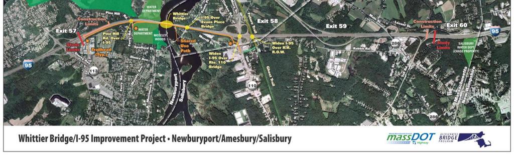
Whittier Bridge I-95 Improvement Project Newburyport/Amesbury/Salisbury
|
|
|
- Alaina Page
- 5 years ago
- Views:
Transcription
1 Whittier Bridge I-95 Improvement Project Newburyport/Amesbury/Salisbury EAE No Public Meeting

2 Whittier Bridge I-95 Improvement Project Newburyport/Amesbury/Salisbury EAE No Public Meeting
3 Project Description MassDOT Proposes to Replace the Current Structurally Deficient John Greenleaf Whittier Bridge and Improve I-95 from Exit 57 (Rte 113) thru Exit 59 (I-495) to Exit 60 The 1951 Whittier Bridge main span is a double-barreled, 3-span continuous riveted steel through truss. Structurally Deficient, Nearing End of Economic Life Highway Geometrically Deficient Substandard Acceleration/Deceleration Lanes and Geometry
4 Accelerated Bridge Program Whittier Bridge is a key component of the MassDOT Accelerated Bridge Program (ABP): $3B commitment over 8 years Goal to reduce the number of structurally deficient bridges: Repair or Remove Current Deficient Bridges, Prevent Additional Bridges from Becoming Classified Structurally Deficient
5 Preferred Bridge Crossing & Alignment Alternative The environmental process has resulted in a Preferred Alternative that has been fully documented and presented through the combined NEPA/MEPA process: Public review of EA/DEIR in process; comments due Dec 23, 2011 FEIR review March to April 2012 NEPA decision MEPA Certificate
6 Today s Agenda Presentation of the Whittier Bridge Project: Preferred Bridge Crossing Preferred Highway Alignment Summary of Combined Environmental Document NEPA Environmental Assessment (EA) MEPA Draft Environmental Impact Report (DEIR) Project Visualization
7 History and Background The Whittier Bridge 1951: Built as part of the 20 mile Rte 1 relocated project to meet NH Turnpike Created as a modern post WWII 4 lane Thruway 1956: Incorporated into Interstate as I : Interchange constructed with I-495, 8 lanes north of Exit s: I-95 widened to 8 lanes south of Bridge and reconfigured to 6 lanes on Bridge to Exit 59
8 Purpose and Need Safety: bridges and roadway geometry, accidents, poor structural rating of Whittier Bridge Purpose of the Project: Improve safety Provide for bridge crossing meeting current standards Improve traffic flow Improve air quality by reducing congestion on I-95 Support alternative (or non-motorized) modes of transportation

9 Project Summary
10 Bridges I-95 Bridge Replacement Whittier Evans Place I-95 Bridge Rehabilitation/Widening Rte 110 RR Bridges Pine Hill Bridge Replacement Over I-95
11 Whittier Bridge NW View East Bridge Alignment Option Phase II - Demolition Underway NB Open with NB & SB Traffic
12 Pine Hill Bridge Replacement

13 I-95 Inside Widening Take Advantage of 60 Wide Median Minimize Impacts to Route 110 Ramp Terminals Horizontal Curve Location Bridge Pier Constraints Reduced Environmental Impacts Widen Bridges RR RT 110
14 Inside Widening View Looking North
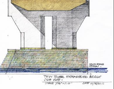
15 Whittier Bridge Types Studied Five River Bridge Types Investigated Conventional Steel Girder Boxes (Steel and Concrete) Network Tied Arch Single Tower Extradosed Single Tower Cable Stay

16 Existing Bridge View Perspectives Merrimack River Chain Bridge

17 Proposed Girder Merrimack River Chain Bridge

18 Proposed Cable Stay Merrimack River Chain Bridge

19 Proposed Single Extradosed Merrimack River Chain Bridge


20 Proposed Network Arch Merrimack River Chain Bridge


21 Whittier Bridge Crossing Existing Crossing Preferred Crossing


22 Historic Elements Portal Bracing

23 Whittier Bridge Northbound


24 Historic Elements Builders Plaque


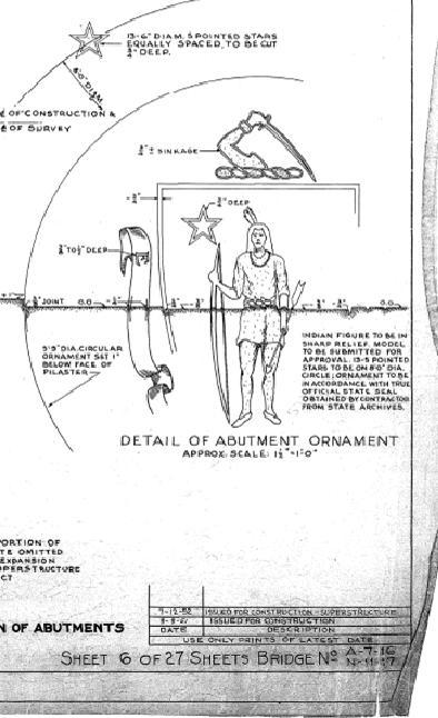
25 Historic Elements Wall Seal

26 Historic Elements Abutment Date & Seal

27 Bridge Piers 1951 Construction Proposed Pier
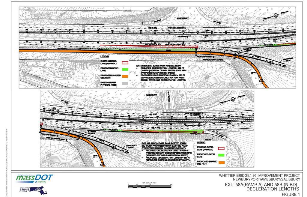
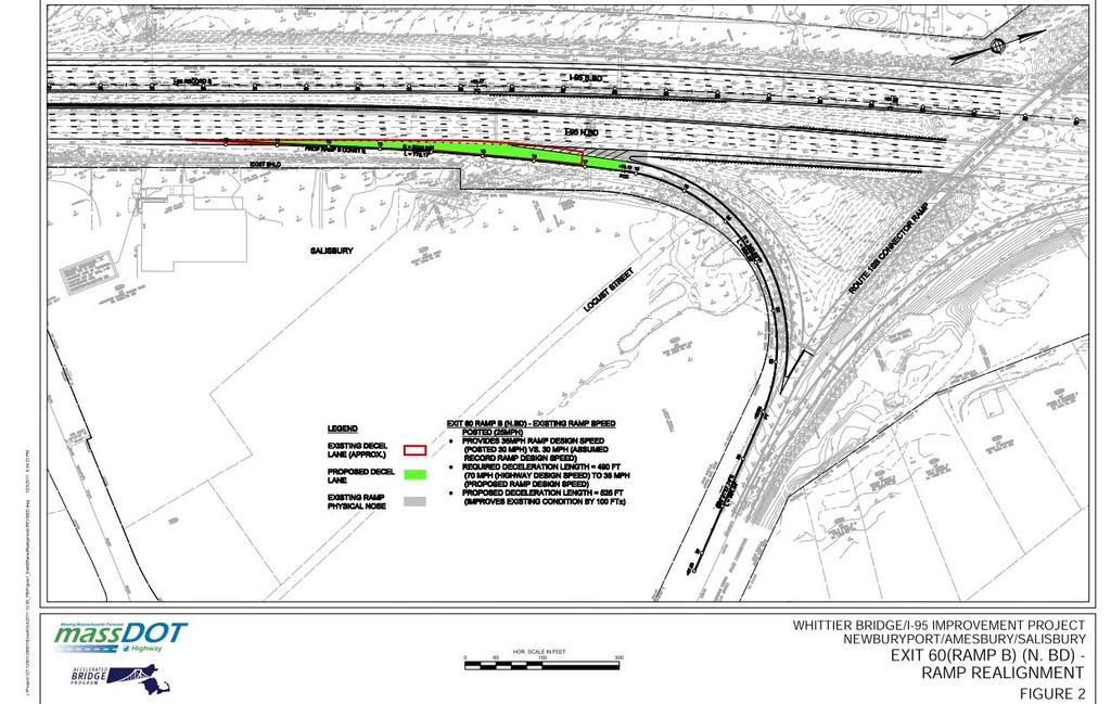
28 Ramp Safety Improvements Deceleration Lane Improvements to: Exit 58 I-95 NB to RT 110 E Design speed from 25 to 35 mph Exit 58 I-95 NB to RT 110 W Design speed from 20 to 25 mph Exit 60 I-95 NB to Toll Rd E Design speed from 25 to 35 mph
29
30
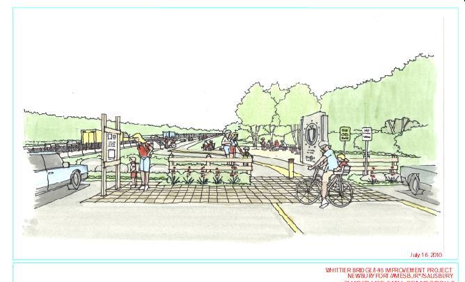
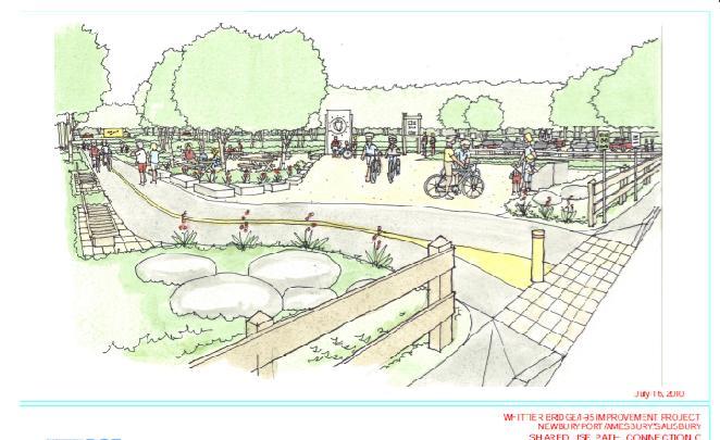
31 Alternative Transportation October 22, 2010 Port bridge first to get bike lane Path that will connect rail trails included in plan for Whittier The Whittier Bridge Project on Interstate 95 in Salisbury, Newburyport and Amesbury will include bicycle and pedestrian access. The agreement marks the first time in the history of the Commonwealth that a bicycle/pedestrian path has been located on an interstate highway bridge.
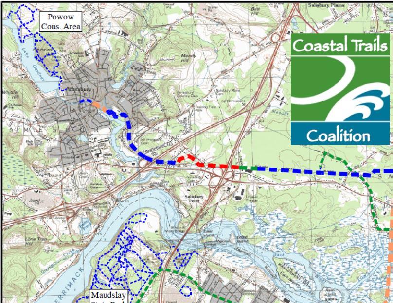
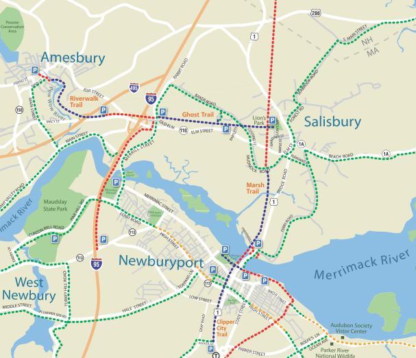


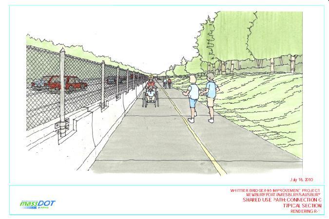
32 Shared-Use Trails Existing & Planned Trails Strong Existing Network Whittier Project Park & Ride to Rt110
33
34

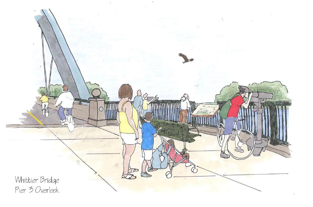
35 Proposed Overlook

36 Modeled Overlook
37
38 Alternatives Analysis NEPA and MEPA requirement to analyze project alternatives Screening for environmental and engineering criteria Includes both river crossing and highway widening alternatives including No Build alternative
39 Alternatives Analysis Results Preferred Alternative: 8-Lane Bridge River Crossing alternative with Inside Widening to Route 286 including the Shared-Use Path Best met the criteria of: Purpose and Need, Highway Configuration, Traffic, Bridge Configuration, Construction, ROW, Environmental

40 Affected Environment Description of existing environment in study area Baseline for potential impacts of Preferred Alternative
41 Affected Environment Topography, Geology and Soils Land Use and Visual Resources Open Space and Recreational Resources Traffic and Safety Air Quality Noise Water Resources Fisheries
42 Affected Environment Wildlife Wetlands Floodplains Historic and Archaeological Resources Oil and Hazardous Materials Utilities/Stormwater Economics Navigation
43 Environmental Consequences Assessment of Preferred Alternative compared to No Build 2030 is the design year for traffic Extent of permanent and temporary impacts Secondary and cumulative impacts Avoidance and minimization Identification of mitigation measures
44 Mitigation Visual Impacts: snow fence at Whittier Point Traffic Noise: noise barriers are not warranted per MassDOT policy Construction Noise: specifications to address noise impacts Water Quality: improved stormwater management system
45 Mitigation Fisheries: Construction specifications on inwater work Historic Resources: Section 106 Memorandum of Agreement, archival documentation, reuse decorative bridge elements Oil and/or Hazardous Materials: Construction specifications for handling/management of contaminated soils
46 Mitigation Navigation: Measures to maintain navigation channels Construction: staging of construction to minimize impacts, traffic management plan
47 Permit Compliance Address compliance and consistency with specific federal and state law, regulations and policies Permits: US Coast Guard Bridge Permit US Army Corps of Engineers Permit National Historic Preservation Act Section 106 Coastal Zone Management Consistency Determination Endangered Species Act Section 7 and Essential Fish Habitat clearance
48 Permit Compliance Mass Department of Environmental Protection (DEP) Water Quality Certification Mass DEP Chapter 91 Waterways License Wetlands Protection Act Orders of Conditions Mass Natural Heritage and Endangered Species
49 Comments and Coordination NEPA and MEPA encourage early and continuous public and agency involvement Response to comments on MEPA Environmental Notification Form and subsequent public comments Summarize public involvement activities Includes copies of relevant agency correspondence
50 Next Steps Submit comments on the EA/DEIR due December 23, 2011 Final EIR to be filed February 2012 with public comment March/April NEPA Decision MEPA FEIR Certificate
51 Ongoing Public Process Continue public involvement 25% Design Public Hearing Spring 2012
52 Project Schedule - Revised Started Environmental Study: November 2008 Data Acquisition; Field Studies, Survey, Research, Started Public Outreach: March 2009 Filed ENF: June 1, 2009 Public Review of EA/DEIR: Nov 23 - Dec 23, 2011 File FEIR: Feb 28, 2012 MEPA/NEPA Approvals by April 2012 Begin Design/Build Procurement Process: April 2012 Design Public Hearing: Spring, 2012 Construction Start: Spring 2013
53 Project Visualization Viewport Construction Staging Walkthru

54 Questions & Answers To be added to the project distribution database, please contact: Stephanie Boundy, Public Outreach Coordinator MassDOT, Accelerated Bridge Program or
55 The purpose of this meeting is to seek public comment on the Environmental Assessment/Draft Environmental Impact Report for the proposed Whittier Bridge/I-95 Improvement Project. The EA/DEIR document is available on the project website at and print copies and/or DVDs may be obtained by contacting James Cerbone at or Comments on this document are due by December 23, 2011 and should be sent to: Pamela S. Stephenson, Division Administrator Federal Highway Administration 55 Broadway, 10th Floor Cambridge, MA Attention: Damaris Santiago Or by Thomas F. Broderick, P.E., Acting Chief Engineer MassDOT Highway Division 10 Park Plaza Boston, MA Attention: James Cerbone Or by Richard K. Sullivan, Jr., Secretary Massachusetts Environmental Policy Act (MEPA) Office 100 Cambridge Street, 9th Floor Boston, MA Attention: Purvi Patel EAE No