INVESTIGATING WATERSHEDS
|
|
|
- Melina Lewis
- 5 years ago
- Views:
Transcription
 -salt flour dough (recipe included) -water -paper -waterproof")
 -teacher sheets (included) -transparency -overhead projector B A C K G R O U N D I N F O R M A T I O N The concept of watersheds is a useful way to divide areas of land according to")
1 INVESTIGATING WATERSHEDS Objectives: The student will be able to: Simulate runoff using a watershed model. Explain why rivers are necessary to drain water from watersheds. Suggested Grade Level: 6-8 Subjects: Science, Social Studies Time: 60 minutes Materials: -maps showing area - watershed (1 per -student) -salt flour dough (recipe included) -water -paper -waterproof paint -picture of a river and surrounding area -sprinkling can -9 x 13 (25 x 35 cm) pan at least 2 deep -drawing paper -measuring cup -world maps (1 per team) -U.S. maps (1 per team) -teacher sheets (included) -transparency -overhead projector B A C K G R O U N D I N F O R M A T I O N The concept of watersheds is a useful way to divide areas of land according to how the land and the water flowing over and through it interact. A particular watershed is an area or region which drains into a particular watercourse or body of water. Watersheds are important because scientists can study them in order to help determine how much surface water is available for people s needs. The topography, vegetation, soil, rock formations, and climate of a watershed also determine an area s lakes, streams, and rivers. Generally, two adjacent watersheds are separated by a high area of land called a divide. As an example the watershed of the Columbia River America s largest watershed, the watershed of the Mississippi River, are separated by the Great Divide in the Rockies. Large amounts of runoff from watersheds, occurring in short periods of time, can lead to severe flooding and destruction of land and property. Sometimes heavy rains can result in flooding even when a watershed s rivers are quite large. T E R M S basin: a low lying area where surface water flows, such as a river basin. runoff: water (originating as precipitation) that flows across surfaces rather than soaking in; eventually enters a water body; may pick up and carry a variety of pollutants. topography: the physical features of a place or region. watershed: land area from which water drains to a particular water body. A D V A N C E P R E P A R A T I O N A. Construct a generalized relief map of a watershed. Use salt dough in a pan at least 9 x 13 (25 x 35 cm) and 2 (5 cm) deep. B. Order or locate maps showing your local watershed area. Obtain one per student. (NOTE: Call the United States Geological Surveys Earth Science Information Center at USA-MAPS to request specific maps. For local maps, contact the local water department, state agricultural department, state geological survey, or perhaps the department of geology at the nearest college or university.) C. Obtain enough U.S. maps and world maps for there to be one for each team of four students. 1
2 D. If you invite a geologist to class, make sure he/she is informed as to what the objectives are and what to teach the students. I. Setting the stage P R O C E D U R E A. Show the students a picture of a river and the surrounding lands. 1. Ask the students where the water in the river came from. Write their responses on the board. 2. Explain to the students that most of the water in our rivers comes from water that has drained off the surrounding land. Remind the students that water runs downhill. If it is a rainy day, observe this at your school. What you can observe in your school s parking lot or yard also happens on a much larger scale over very large areas of land. 3. Discuss the words runoff and watershed. B. Show your class a transparency or photocopy of the teacher sheet, Watersheds. Note that it shows two watersheds. II. Activity A. Give each student a copy of a watershed map (or any map showing topography) of your local area. 1. Have the students trace some of the paths water takes to get from the various parts of the watershed to the streams, rivers, and lakes. 2. Ask the students to tell you where they think the river will eventually take the water collected from the watershed area. B. Present the model of the watershed area to the class. 1. Explain the concepts of valley, hill, mountain, and so forth, to your students by pointing them out on the model. 2. Using a sprinkling can, have it rain over the model. Ask the students to observe how water runs over the area and to note where it collects. (the rivers) 3. Explain to the students that areas where water has pooled become our bodies of water, such as lakes, ponds, streams, and rivers. C. Continue sprinkling the model until the pan begins to fill. 1. Explain to the students that if water has no way to be carried off, then flooding occurs. (Flooding also occurs when water cannot be carried off quickly enough.) 2. Asks the students what is needed to carry the water away from the watershed. (river) 2
3 III. Follow-Up A. Ask the students to write a paragraph telling you how a watershed and a river are interrelated. B. Pass out drawing paper to the students. Have the students draw a watershed and color it. C. Divide students into teams of four and give each team a map of the U.S. (New England, Southeast, etc.) and have them find and record the major rivers in that section of the country. 1. Ask the teams to list states that are not part of the Mississippi River watershed. 2. Tell teams to find two rivers that do not empty into another river, but empty directly into the ocean D. Pass out the world maps to the teams. 1. Have the teams trace and list a few rivers that flow into Africa s Congo River. Explain to the teams that the Congo is a major watershed river in Africa. 2. Ask the teams to trace and list some of the rivers that flow into South America s Amazon River. Explain to the teams that the Amazon River is a major river for South America. IV. Extensions Invite a geologist to class to explain how topographical maps are made. If possible, request they bring booklets that can be given to each student. R E S O U R C E S Douglas, L. S., et al., Experiences in Earth-Space Science, Laidlaw Brothers, Irvine, California, Thank you to the Environmental Protection Agency Water Sourcebook for this activity! 3

4 SALT DOUGH RELIEF MAP Salt Flour Dough (NOTE: Makes between 1-1/2 and 2 cups of dough. The recipe should be doubled in order to make enough for the relief map. You might make it in 2 batches to ensure success.) 1 cup (250 ml) flour 1/2 cup (125 ml) salt 1 cup (250 ml) water 1 tablespoon (15 ml) cooking oil 2 teaspoons (10 ml) cream of tartar Mix and heat ingredients until a ball forms. Add a touch of food coloring if desired. To make model: Try to create a relief map similar to what is depicted on the teacher sheet, Watersheds. On one end of the pan, let the two major valleys come together to form one larger one (like a Y ). Make a riverbed (depression) at the bottom of each major valley. Make sure that the end of the pan with the bottom of the Y is lower than the other end; i.e., the dough should be shallow at that end. Allow the model to dry. Have several students paint it with waterproof paint. Using waterproof paint protects the model so that it can be reused. 4
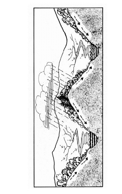
5 Watersheds 5